|
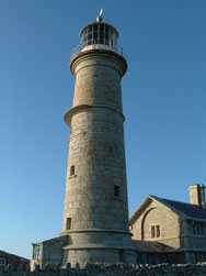
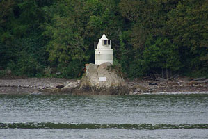
This page shows the Lighthouses of England. Note that Wales is a separate page. You can click on the photo of the light to go to it's specific (larger resolution) copy. Each lighthouse name is linked to (in our editorial opinion) the best reference site for that light. Please bear with me viewers as I renumber England.
|
|
EN 1
[EN0E] |
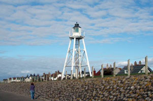
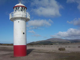
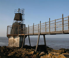
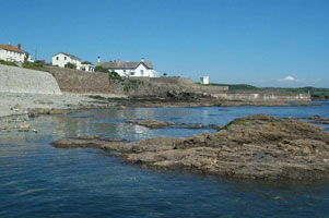
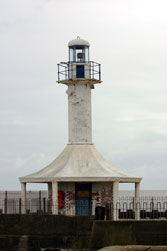
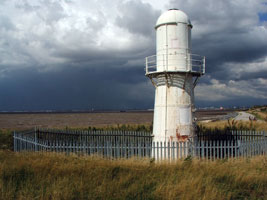
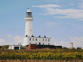
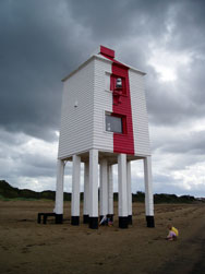
East Cote (Skinburness)
latitude 54° 52' 47.3" N longitude 3° 22' 50.9" W
Located on Skinburness Road about 1 km north of the harbor of Silloth, on the south side of Solway Firth. (A 4671) ARLHS # ENG-318
Photo courtesy Owlet2007 [Flickr] |
|
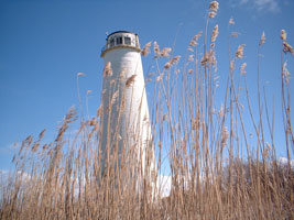
EN 2
[EN0L] |
| Lees Scar (Tommy Legs)
latitude 54° 51' 46.4" N longitude 3° 24' 47.3" W
Located about 800 m south of Silloth. Accessible only by boat. (A 4670) ARLHS # ENG-064
Photo courtesy Alex Trabas [liteslist] |
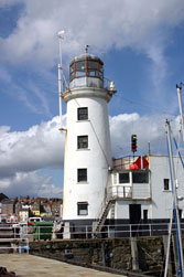
EN 3
[EN0M] |
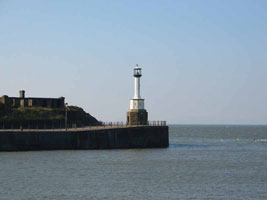
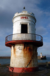
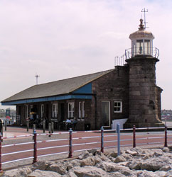
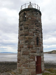
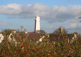
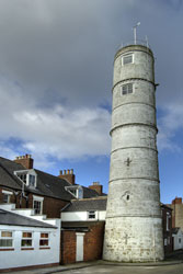
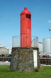
Maryport (1846)
latitude 54° 43' 1" N longitude 3° 30' 27.4" W
Located at the base of the west quay in Maryport. ARLHS # ENG-080 |
|
EN 4
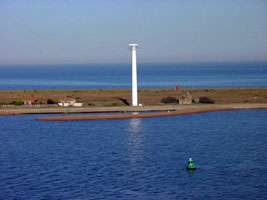
[EN1] |
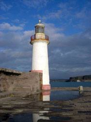
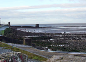
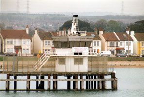
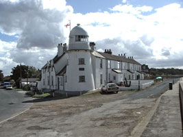
| Maryport (1996)
latitude 54° 43' 4.1" N longitude 3° 30' 38.5" W
It is believed a lighthouse was established here in 1796. It was converted to acetylene in 1946. This light is constructed of aluminium and was built in 1996. Located at the end of the south pier at Mayport. (A 4676)
Photo courtesy Alex Trabas [liteslist] |
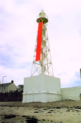
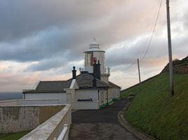
EN 5
[EN1E] |
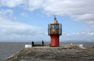
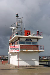
Whitehaven North Pier
latitude 54° 33' 10.1" N longitude 3° 35' 44.9" W
Located at the end of the northeast breakwater at Whitehaven. (You can see the west pier in the background). (A 4700) ARLHS # ENG-166
Photo courtesy Multum in Parvo [Flickr] |
|
EN 6
[EN1L] |
| Whitehaven West Pier
Located at the end of the west breakwater at Whitehaven. (A 4698) ARLHS # ENG-245
Photo courtesy Val and Chris [webshots] |
EN 7
[EN1M] |
Whitehaven Old New Quay (Old Outer Quay)
latitude 54° 32' 60" N longitude 3° 35' 33.7" W
The tower was undoubtedly a day beacon, but it isn't clear if it was ever lit as a lighthouse. Located on the 17th century Old New Quay, which now encloses the Inner Harbour of Whitehaven.
Photo courtesy marinas.com [marinas.com] |
|
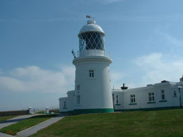
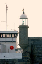
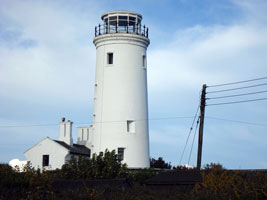
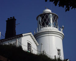
EN 8
[EN2] |
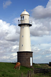
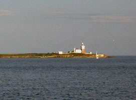
| St. Bees
latitude 54° 30' 49.2" N longitude 3° 38' 12.1" W
South of the harbours of Maryport, Workington and Whitehaven, sandy beaches and grassy foreshores give way to cliffs around St. Bees Head, a high promontory. (A 4710) ARLHS # ENG-142
Photo courtesy Jean Smith [Flickr] |
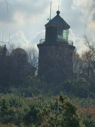
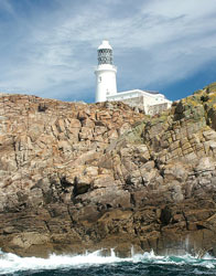
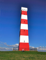
EN 9
[EN4] |
Hodbarrow Point (1905) (Haverigg)
latitude 54° 11' 25.2" N longitude 3° 16' 3.1" W
Located on the Duddon Estuary about 800m west of Hodbarrow Point and 1200 m southeast of Haverigg, accessible by walking the berm in either direction. (A 4805) ARLHS # ENG-054
Photo courtesy Bill Wakefield [Flickr] |
|
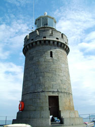
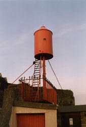
EN 10
[EN5] |
| Hodbarrow Point (1866) (Haverigg, Millom)
Located about 300 m northwest of Hodbarrow Point, a location that was on the coast before the iron mines were expanded in 1905. Accessible by hiking trail. ARLHS # ENG-193
Photo courtesy Bill Wakefield [Flickr] |
EN 11
[EN6] |
Walney
latitude 54° 3' 0.4" N longitude 3° 11' 12.8" W
Walney Island is a barrier island about 15 km long off the west end of the Furness peninsula. The island is accessible by bridge from Barrow-in-Furness on the A590 highway. (A 4820) ARLHS # ENG-161
Photo courtesy piddon [webshots] |
|
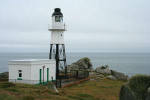
EN 12
[EN7] |
| Rampside (Walney Channel Middle Range Rear)
This tower is the only survivor of 13 range lights built on the approaches to Rampside and Barrow in the 1850-1870 period. Located on the shoreline at Rampside, just off the A5087 about 5 km southeast of Barrow-in-Furness. ARLHS # ENG-201
Photo courtesy Ned Trifle [Flickr] |
EN 13
[EN8] |
Morecambe (Stone Pier)
latitude 54° 4' 28.1" N longitude 2° 52' 42.6" W
This lighthouse formerly guided railroad ferries sailing between Morecambe and Ireland. Located at the end of the Stone Pier in Morecambe, a port on Morecambe Bay about 5 km northwest of Lancaster. (A 4850) ARLHS # ENG-190
Photo courtesy Ian [Flickr] |
|
EN 14
[EN9] |
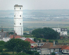
| Near Naze (1904)
latitude 54° 2' 18.1" N longitude 2° 54' 45" W
When Heysham Harbour was built in 1904, this (on the right) lighthouse was apparently built to warn small craft to avoid the adjacent rocky shoal called Near Naze. However, it must have been replaced within a few years by the next lighthouse listed. (A 4863)
Photo courtesy Peter S. Petralia [Flickr] |
EN 15
[EN10] |
Near Naze (1916) (Range Rear)
latitude 54° 2' 16.6" N longitude 2° 54' 42.6" W
This light is on the left above, both lights are located just off Shore Road near the Portway in Heysham. This is a better photo of the light on the left above.
Photo courtesy Eileen Skinner [Flickr] |
|
EN 16
[EN11] |
| Heysham South Pier
latitude 54° 1' 54.8" N longitude 2° 55' 26" W
Located at the end of the south pier; good views from ferries departing Heysham for Ireland and the Isle of Man. ARLHS # ENG 192
Photo courtesy xrichx [Flickr] |
EN 17
[EN12] |
Heysham South Breakwater
latitude 54° 1' 54.5" N longitude 2° 55' 43.7" W
Located at the end of the breakwater, good views from ferries departing Heysham for Ireland and the Isle of Man. (A 4860) ARLHS # ENG-191
Photo courtesy Alex Trabas [liteslist] |
|
EN 18
[EN13] |
| Plover Scar Range Front
latitude 53° 58' 53.4" N longitude 2° 52' 57.6" W
The rear range lighthouse was replaced in 1963 by a 15 m skeletal tower. Located about 400 m off shore at the southern entrance to the River Lune about 3 km southwest of Glasson. Accessible only by boat, but easily seen from shore. (A 4876) ARLHS # ENG-315
Photo courtesy Zak [Flickr] |
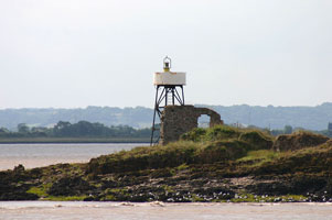
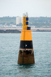
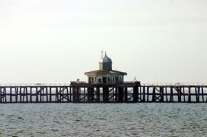
EN 20
[EN14] |
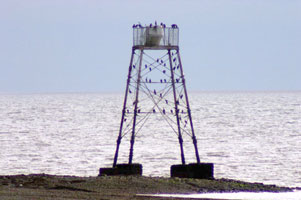
Wyre
This was the world's first successful screwpile lighthouse, so the site has great significance in lighthouse history. Located on the North Wharf Sandbank at the entrance to the narrow channel to Fleetwood, about 2.5 km north of the town. Accessible only by boat. ARLHS # ENG-171
Photo courtesy Karl Huelse [leuchturm] |

|
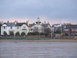
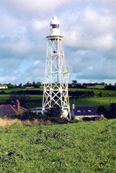
EN 21
[EN15] |
| Fleetwood Low
latitude 53° 55' 42.6" N longitude 3° 32.8" W
The building has a neoclassical design unusual for a lighthouse. Located on the esplanade at the west side of the mouth of the River Wyre in Fleetwood. (A 4892) ARLHS # ENG-195
Photo courtesy The Killer Biscuit [Flickr] |
EN 22
[EN16] |
Fleetwood High
latitude 53° 55' 35.4" N longitude 3° 27.4" W
These two fine lighthouses are among the town's best known architectural monuments. Located in the middle of a street 320 m south of the front light. (A 4892.1) ARLHS # ENG-043
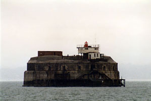
Photo courtesy John Burke [Flickr] |
|
EN 23
[EN17] |
| Blackpool Range Rear
latitude 53° 48' 26.3" N longitude 3° 3' 21.6" W
Located on the Promenade in downtown Blackpool, near Lytham and Rigby Roads. ARLHS # ENG 282
Photo courtesy The Killer Biscuit [Flickr] |
EN 24
[EN19F] |
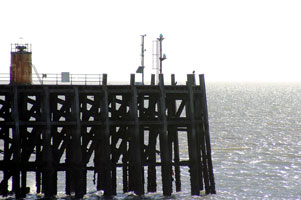
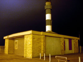
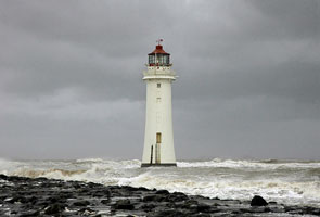
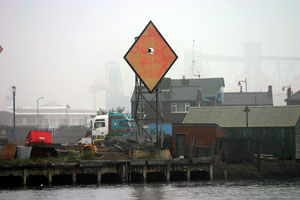
Perch Rock (New Brighton)
Located just offshore from the New Brighton Fort, also a privately owned attraction, at the west side of the entrance to the Mersey estuary at New Brighton. It is possible, with caution, to walk to the lighthouse at low tide. The name comes from the first light which was just a wooden perch on Black Rock. fort ARLHS # ENG-084
Photo courtesy MaddieDigital [Flickr] |
|
EN 26
[EN18] |
Hale Head
latitude 53° 19' 20.6" N longitude 2° 47' 39.5" W
Located on a promontory on the north bank of the Mersey about 4 km east of Liverpool John Lennon Airport. Accessible by an easy walk of about 1200 m from Hale Church. ARLHS # ENG-187
Photo courtesy rawmusic [Flickr] |
|
EN 27
[EN19] |
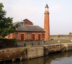
| Upper Mersey (Ellesmere Port)
Located on South Pier Road in Ellesmere Port, just off the south bank of the Mersey at the junction of the Shropshire Canal and the Manchester Ship Canal. ARLHS # ENG-278
Photo courtesy Steve F [geograph] |
EN 28
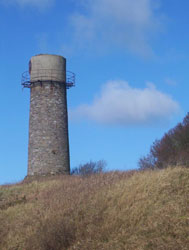
[EN19H] |
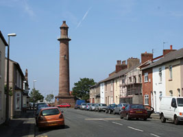
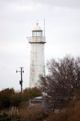
Bidston Hill
Bidston Hill is more than a mile from the sea, but as the highest hill in the Liverpool area it was the natural site for a landfall light for the Mersey. ARLHS # ENG-009
Photo courtesy markhsal [Flickr] |
|
EN 29
[EN19L] |
| Leasowe
latitude 53° 24' 47.2" N longitude 3° 7' 33" W
Located on Leasowe Common in Moreton, about 8 km west of Perch Rock Light, the station is included in the North Wirral Coastal Park. park ARLHS # ENG-063
Photo courtesy Harry Moon [Flickr] |
EN 30
[EN19K] |
Hoylake (High)
Located just off Market Street (A553) in Hoylake, at the east side of the entrance to the River Dee. Site and tower closed, but the lighthouse can be seen easily from the street. ARLHS # ENG-055
Photo courtesy Bob Gore [Flickr] |
|
EN 31
[EN19Q] |
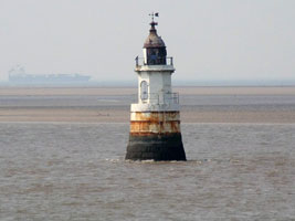
| Hilbre Island
latitude 53° 23' 0.4" N longitude 3° 13' 41.9" W
River Dee estuary. This light is fully automated and contains no keepers quarters. Thus it won't appear on all lists. (A 5115) ARLHS # ENG-223
Photo courtesy Alexander Trabas [ListOfLights] |
Southern England
EN 35
[EN20F] |
Berkeley Pill Range Rear
latitude 51° 41' 53.6" N longitude 2° 29' 25.6" W
ditto (A 5556.1)
Photo courtesy Alex Trabas [liteslist] |
|
EN 36
[EN20E] |
| Berkeley Pill Range Front
latitude 51° 41' 59" N longitude 2° 29' 24.4" W
Located on the south side of the Severn, on Berkeley Pill, a ridge in Hamfields, near Berkeley. Site appears closed, but the lighthouse can be seen from nearby. (A 5556)
Photo courtesy Alex Trabas [liteslist] |
EN 37
[EN20D] |
Sheperdine Range Rear
latitude 51° 40' 5.5" N longitude 2° 33' 9.5" W
Located on the south side of the Severn, off Nupdown Road in Sheperdine. (A 5549.1)
Photo courtesy Alex Trabas [liteslist] |
|
EN 38
[EN20C] |
| Slime Road Range Rear
latitude 51° 37' 11.4" N longitude 2° 39' 7" W
Located on a hill in Beachley. (A 5547)
Photo courtesy Alex Trabas [liteslist] |
EN 39
[EN20A] |
Chapel Rock
latitude 51° 36' 25.6" N longitude 2° 39' 12.3" W
Located on a rock on the north side of the Severn off Beachley, about 650 m downstream from the older Severn Bridge. Accessible only by boat. (A 5541)
Photo courtesy Alex Trabas [liteslist] |
|
EN 40
[EN20B] |
| Lyde Rock
latitude 51° 36' 52.9" N longitude 2° 38' 39.8" W
Clearly the light is now mounted low on the tower. Located on a rock on the north side of the Severn off Beachley, about 300 m upstream from the older Severn Bridge. Accessible only by boat. (A 5545)
Photo courtesy Alex Trabas [liteslist] |
EN 41
[EN20G] |
Avonmouth North Pier
latitude 51° 30' 29.2" N longitude 2° 43' 5.3" W
Located at the end of the pier on the northeast side of the mouth of the River Avon. Visible from many locations on the waterfront in Avonmouth. (A 5492) ARLHS # ENG-003
Photo courtesy Alex Trabas [liteslist] |
|
EN 42
[EN20H] |
| Avonmouth South Pier
latitude 51° 30' 22.2" N longitude 2° 43' 5.8" W
Located at the end of the pier on the southwest side of the mouth of the River Avon. (A 5492.21) ARLHS # ENG-202
Photo courtesy Alex Trabas [liteslist] |
EN 43
[EN20K] |
Portishead Point (Battery Point)
latitude 51° 29' 40.8" N longitude 2° 46' 25.2" W
Located on a promontory just off the Esplanade on the south shore of the Severn in Portishead, about 3 km west of the mouth of the Avon. (A 5484) ARLHS # ENG-106
Photo courtesy Canis Major Photography [Flickr] |
|
EN 46
[EN20N] |
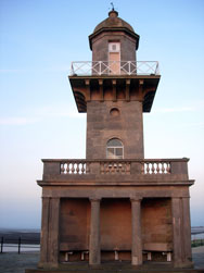
| Burnham-on-Sea High (1832) (Pillar Lighthouse)
latitude 51° 14' 56" N longitude 2° 59' 56.6" W
Located on Berrow Road just north of Stodden's Road, about 500 m east of the low light in Burnham-on-Sea. ARLHS # ENG-018
Photo courtesy Canis Major Photography [Flickr] |
EN 47
[EN20P] |
Burnham-on-Sea-1801 (Burnham Old, Round Tower)
latitude 51° 14' 23.7" N longitude 2° 59' 54.8" W |
Originally four stories tall, the tower was reduced in height so that it would not be confused with the Burnham High Light. Built privately by the local curate, the lighthouse has always been known locally as the Round Tower. Located on the oceanfront Esplanade in Burnham-on-Sea. ARLHS # ENG-323 |
EN 48
[EN20Q] |
Burnham-on-Sea Seafront Range Rear
The light is mounted on the tower of the Church of St. Andrew, a building that dates from 1316. The tower has a slight lean, centuries old, due to sinking foundations. Located near the waterfront in Burnham-on-Sea. church ARLHS # ENG-333
Photo courtesy Bryan Guy [webshots] |
|
EN 49
[EN20R] |
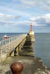
| Watchet Harbour
latitude 51° 11' 2.5" N longitude 3° 19' 43.1" W
Located at the the end of the breakwater on the west side of the harbor at Watchet. (A 5584) ARLHS # ENG-174
Photo courtesy Ian Chilton [Flickr] |
EN 50
[EN21] |
Lynmouth Foreland
latitude 51° 14' 43.5" N longitude 3° 47' 11.7" W
There is a cliff top walk to the foreland along the path leading from the old inn near Countisbury. ARLHS # ENG-044
Photo courtesy Rich Hill [Flickr] |
|
EN 51
[EN21L] |
| Ilfracombe (Lantern Hill)
Located atop Lantern Hill, a steep headland above Ilfracombe Harbour. (A 5594) ARLHS # ENG-059
Photo courtesy Alex Trabas [ListOfLights] |
EN 52
[EN22] |
Bull Point
latitude 51° 11' 56.8" N longitude 4° 12' 4.4" W
This light gives a guide to vessels navigating off the North Devon Coast with a red sector light marking the Rockham Shoal and the Morte Stone off Morte Point.
It's about a mile walk from the car park. (A 5600) ARLHS # ENG-017
Photo courtesy Dave Barfoot [Flickr] |
|
EN 53
[EN23] |
| North Lundy
latitude 51° 12' 6.3" N longitude 4° 40' 38.2" W
At the mouth of the Bristol Channel lies the Island of Lundy. (A 5616) ARLHS # ENG-074
Photo courtesy Adrian Clark [Flickr] |
EN 54
[EN24] |
South Lundy
latitude 51° 9' 43.8" N longitude 4° 39' 21" W
Located atop cliffs at the southern tip of the island, where it is more accessible to visitors than the north light. (A 5618) ARLHS # ENG-075
Photo courtesy Brian Dickson [PBase] |
|
EN 55
[EN24L] |
| Lundy Island (Old Light)
Located on Beacon Hill, the highest point of the island. Site open, keeper's houses open to paying guests, tower open for climbing. ARLHS # ENG-073 |
EN 56
[EN25] |
Braunton Sands Low (Crow Point)
These lights were demolished in 1957. Located on a sandy spit just inside the entrance to the River Taw opposite Instow. ARLHS # ENG-213
Photo courtesy Alex Trabas [liteslist] |
|
EN 57
[EN26F] |
| Instow Range Front
latitude 51° 3' 37.3" N longitude 4° 10' 39.8" W
The range guides ships through the narrow channel into the River Taw. (A 5610)
Photo courtesy Alex Trabas [liteslist] |
EN 58
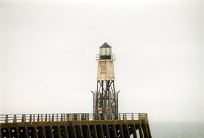
[EN26] |
Instow Range Rear
latitude 51° 3' 31.3" N longitude 4° 10' 21.2" W
The front range light is on a skeletal tower, the two lights guide ships through the narrow channel into the River Taw. Located just off Anstey Way on the north side of Instow. (A 5610.1)
Photo courtesy Alex Trabas [liteslist] |
|
EN 59
[EN27] |
| Hartland Point
latitude 51° 1' 18.9" N longitude 4° 31' 31.2" W
Hartland Point is a right-angled turn in the coastline at the extreme southwestern entrance to Bristol Channel. Located about 5 km northwest of Hartland. The road to the lighthouse is gated at a parking area for the Southwest Coast Path, good views of the light station are available by taking the path west and south. (A 5621) ARLHS # ENG-051
Photo courtesy Adrian Boliston [PBase] |
EN 60
[EN28] |
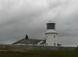
Trevose Head
latitude 50° 32' 57.5" N longitude 5° 2' 6.5" W
Trevose Head is a peninsula at the northwestern tip of Cornwall. The former low light was discontinued in 1882. Located about 8 km northwest of Padstow. (A 5638) ARLHS # ENG-157
Photo courtesy Hugo H. [Flickr] |
|
EN 61
[EN29] |
| Godrevy
latitude 50° 14' 32.9" N longitude 5° 24' 0.8" W
Godrevy Island is situated 3½ miles across St.Ives Bay. Located about 500 m off Godrevy Point near Gwithian at the northeastern entrance to St. Ive's Bay. There are excellent views from the Southwest Coast Path. (A 5655) ARLHS # ENG-047
Photo courtesy Ennor [Flickr] |
EN 62
[EN30] |
Pendeen
latitude 50° 9' 53.7" N longitude 5° 40' 17.9" W
Located on the promontory called Pendeen Watch, about 2 km north of the B3306 highway at Pendeen. (A 5670) ARLHS # ENG-101
Photo courtesy Simon Jones [Flickr] |
|
EN 63
[EN31] |
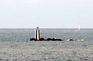
Lightship Seven Stones |
No longer crewed, the ship is operated automatically. Located on the Seven Stones Reef, northeast of the Isles of Scilly and northwest of Land's End. (A 0020) |
|
|
EN 64
[EN32] |
Round Island
latitude 49° 58' 44.7" N longitude 6° 19' 23.4" W
Located on the northernmost of the Isles of Scilly, a bare rocky island northeast of Tresco. The only access, apart from by helicopter, is by a flight of steps out into the solid rock. (A 0018) ARLHS # ENG-118
Photo courtesy Jo Parsons [Flickr] |
|
EN 65
[EN33] |
| Peninnis
latitude 49° 54' 16.6" N longitude 6° 18' 12.7" W
on St Mary’s Island in the Isles of Scilly (A 0006) ARLHS # ENG-102
Photo courtesy Roger Picton [Flickr] |
EN 66
[EN33S] |
St. Agnes
latitude 49° 53' 33.1" N longitude 6° 20' 43.3" W
The lighthouse was replaced by the Peninnis Head Light. Located at the highest point of St. Agnes, southwesternmost of the main Isles of Scilly. A friend of Jo's lives here now, and uses the lantern space as a greenhouse. ARLHS # ENG-140
Photo courtesy Jo Parsons [Flickr] |
|
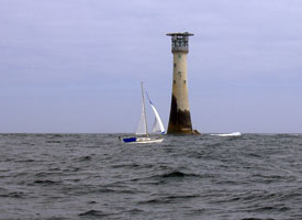
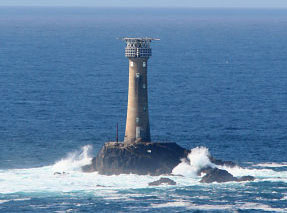
EN 67
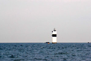
[EN34] |
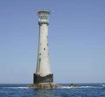
| Bishop Rock
on a rock ledge 46m long by 16m wide, 4 miles west of the Isles of Scilly. (A 0002) ARLHS # ENG-010
Photo courtesy Jeremy Pearson [Flickr] |
EN 68
[EN35] |
Wolf Rock
This light is four miles south west of Lands End and between the Isles of Scilly. (A 0030) ARLHS # ENG-170
Photo courtesy Phil Biggs [Flickr] |
|
EN 69
[EN36] |
| Longships
latitude 50° 4' 1" N longitude 5° 44' 48.8" W
Around the cliffs of Land's End, at the extreme south-west point of British mainland (A 0028) ARLHS # ENG-069
Photo courtesy Rich McD [PBase] |
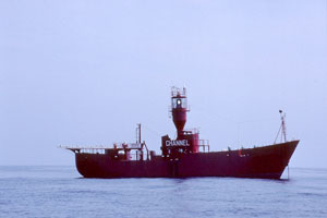
EN 74
[EN43] |
Channel lightship
Note that the name of the lightship is Channel. I had assumed this was a lazy name, but it is accurate. (A 1520)
Photo courtesy Kees Aalbersberg [ListOfLights] |
|
EN 76
[EN45] |
Alderney
This light is sited on Quénard Point, to the north-east of the Island. (A 1536) ARLHS # GUE-004
Photo courtesy Sylvia [Flickr] |
|
EN 77
[EN46] |
| Sark
Sark is a small island (5 km by 2 km) located east of Guernsey and accessible by passenger ferry from St. Peter Port, transportation on the island is by foot, bicycle, or horse-drawn carriage. Located on a cliff at the northeastern point of the island; accessible by a staircase of 165 steps down from the top of the cliff. ferry (A 1544) ARLHS # GUE-003
Photo courtesy Harmuth Schnörrle |
EN 78
[EN47] |
Tautenay
This appears to be an early nineteenth century daybeacon fitted with a modern light. Located about 5 km east of the northeastern point of the island. Accessible only by boat. (A 1548.5) ARLHS # GUE-001
Photo courtesy Klaus Potschien [ListOfLights] |
|
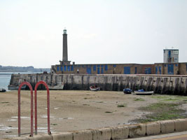
EN 79
[EN47B] |
| Platte Fougère
Located about 2 km off the northeastern point of the guernsey island. Accessible only by boat, but visible from land at Fort Doyle. (A 1548) ARLHS # GUE-006
Photo courtesy Kees Aalbersberg [ListOfLights] |
EN 80
[EN47D] |
Platte |
Located about 1 km off the northeastern shore of the island. Accessible only by boat. ARLHS # GUE-014 |
EN 84
[EN47K] |
Victoria Marina (Range Front) |
Located on the Victoria Pier in St. Peter Port. ARLHS # GUE-009 |
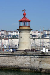
EN 85
[EN47J] |
White Rock Pier
latitude 49° 27' 22.8" N longitude 2° 31' 35.4" W
Located at the end of the pier in St. Peter Port. (A 1562) ARLHS # GUE-010
Photo courtesy Klaus Potschien [ListOfLights] |
|
EN 86
[EN47H] |
| Castle Breakwater (St. Peter Port New Harbour Range Front)
latitude 49° 27' 18" N longitude 2° 31' 27" W
This light is located at the end of the breakwater at St. Peter Port. ARLHS # GUE-005
Photo courtesy goynang [Flickr] |
EN 87
[EN47I] |
Belvedere (St. Peter Port New Harbour Range Rear)
latitude 49° 26' 54" N longitude 2° 31' 58.8" W
A short metal tower on the hill behind the town. (A 1560.1)
Photo courtesy Klaus Potschien [ListOfLights] |
|
EN 88
[EN47P] |
| Noirmont Point
latitude 49° 9' 54.7" N longitude 2° 10' 5.2" W
Located on a rocky point just offshore at the western end of St Aubin's Bay on the southwestern coast of Jersey. Accessible at low tide by wading. (A 1616) ARLHS # JER-007
Photo courtesy Thomas Philipp [ListOfLights] |
EN 89
[EN47R] |
Demie de Pas
Located on a rock off the harbor of St. Helier on the southeast coast of the island. Accessible only by boat. (A 1598) ARLHS # JER-002
Photo courtesy Heike + Friedrich Klatt [ListOfLights] |
|
EN 90
[EN47S] |
| Grève d'Azette (Range Front)
latitude 49° 10' 9.6" N longitude 2° 5' 5.8" W
Located on the coastal road (A4) about 2.5 km southeast of St. Helier on the south coast of Saint Aubin's Bay. (A 1594) ARLHS # JER-005
Photo courtesy Joan und Gary Trigwell [ListOfLights] |
EN 91
[EN47T] |
Mont Ube (Range Rear)
latitude 49° 10' 17.9" N longitude 2° 3' 36.2" W
Located 1.9 km east of Grève d'Azette; should be close to the A5 highway. (A 1594.1)
Photo courtesy Joan und Gary Trigwell [ListOfLights] |
|
EN 92
[EN47U] |
| Gorey Pier (Range Front)
latitude 49° 11' 48.6" N longitude 2° 1' 20.5" W
Located at the end of the pier in Gorey, on the east side of the island. ARLHS # JER-003
Photo courtesy Heike + Friedrich Klatt [ListOfLights] |
EN 93
[EN47V] |
Sorel Point
latitude 49° 15' 36.2" N longitude 2° 9' 32.7" W
Located atop the cliff on the northernmost point of Jersey. (A 1584) ARLHS # JER-008
Photo courtesy Dave Medcalf [Flickr] |
|
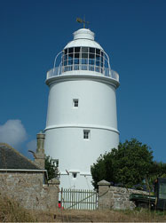
EN 94
[EN47A] |
![[La] Corbière](UK/England/Corbiere.jpg)
| [La] Corbière
latitude 49° 10' 47.5" N longitude 2° 15' 0.8" W
One of the most photographed buildings in Jersey is the lighthouse at La Corbiere- meaning 'gathering place of the crows' - on the south west coast of Jersey. The lighthouse is perched atop a rock just off the southwestern tip of Jersey. It is accessible by a causeway at low tide, but visitors must take care not to be stranded when the tide returns. (A 1620) ARLHS # JER-001
Photo courtesy Sylvia [Flickr] |
EN 95
[EN37] |
Tater-Du
latitude 50° 3' 8.7" N longitude 5° 34' 38.7" W
a headland on the south Cornwall coast to the west of Penzance (A 0032) ARLHS # ENG-152
Photo courtesy Stuart [Flickr] |
|
EN 96
[EN37H] |
| Newlyn Harbour South Pier
latitude 50° 6' 11" N longitude 5° 32' 33.8" W
Located at the end of the pier in Newlyn, on the south side of Penzance. (A 0038) ARLHS # ENG-236
Photo courtesy exmouth [webshots] |
EN 97
[EN37P] |
Penzance South Pier
latitude 50° 7' 3.7" N longitude 5° 31' 40.7" W
Located at the end of the south pier, also called the Lighthouse Pier, near the Scilly Isles ferry terminal. * (A 0046) ARLHS # ENG-240
Photo courtesy Richard and Gillian Long [Flickr] |
|
EN 98
[EN37R] |
| Marazion
latitude 50° 7' 21.6" N longitude 5° 28' 14.3" W
Located on the harbor wall at Marazion, on Mount's Bay opposite St. Michael's Mount, about 8 km east of Penzance. mount ARLHS # ENG-331
Photo courtesy © Simon Lewis [westcountryviews] |
EN 99
[EN38] |
Lizard Point
latitude 49° 57' 36" N longitude 5° 12' 9.2" W
the most southerly point of mainland Britain (A 0060) ARLHS # ENG-068
Photo courtesy Rich McD [PBase] |
|
EN 100
[EN39] |
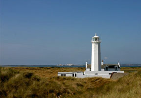
| St. Anthony's
latitude 50° 8' 27.6" N longitude 5° 57.5" W
at the eastern entrance to Falmouth Harbour (A 0062) ARLHS # ENG-141
Photo courtesy mizzledrizzle [Flickr] |
EN 101
[EN39B] |
Mevagissey (South Breakwater)
latitude 50° 16' 6.4" N longitude 4° 46' 57.8" W
Located at the end of the breakwater in Mevagissey, about 7 km south of St. Austell. (A 0078) ARLHS # ENG-234
Photo courtesy Crazy Eddie [Flickr] |
|
EN 102
[EN39G] |
| Gribben Head
latitude 50° 19' 0.8" N longitude 4° 40' 23.5" W
Located on the headland, about 75 m above the sea about 2 km southwest of Fowey. Accessible by walking the coastal trail. trail
Note that this is only a day mark as there is no light in the tower.
Photo courtesy Chris Last [Flickr] |
EN 103
[EN39P] |
Whitehouse Point
latitude 50° 19' 58.8" N longitude 4° 38' 16.7" W
Located on the west side of the harbor at Fowey. (A 0084) ARLHS # ENG-217
Photo courtesy Alex Trabas [liteslist] |
|
EN 104
[EN39S] |
| Spy House Point (Polperro)
latitude 50° 19' 48.3" N longitude 4° 30' 56.1" W
Located at the entrance to the harbor of Polperro, a small port about 10 km east of Fowey. (A 0090) ARLHS # ENG-243
Photo courtesy Alex Trabas [liteslist] |
EN 105
[EN40] |
St. Catherine's Point
June 5, 2005
Fowey (pronounced Foy) is a small town in Cornwall. It had a big enough harbor for our boat, but not a dock big enough, so we went ashore using the boat's tender. At the end of the day, on the way out, we saw this light. (A 0082) ARLHS # ENG-143 |
|
EN 106
[EN40A] |
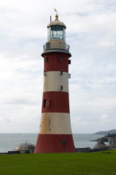
| Eddystone (1759) (Smeaton's Tower)
latitude 50° 21' 37.8" N longitude 4° 9' 47.2" W
When the current Eddystone lighthouse was built, the upper 2/3 of the 1759 tower was saved for reassembly in Plymouth. Smeaton's tower was the first successful stone waveswept tower and one of the great engineering marvels of the 18th century.
Located on Plymouth Hoe, a grassy hill overlooking the town and harbor. ARLHS # ENG-091
Photo courtesy Mike Caine [Flickr] |
EN 108
[EN41P] |
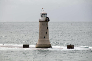
| Plymouth Breakwater
latitude 50° 21' 33.8" N longitude 4° 8' 7.2" W
The Plymouth Breakwater, a major engineering project of the early nineteenth century, was built in stages between 1812 and 1847. Located near the end of the breakwater at the southwestern entrance to Plymouth Harbour. (A 0114) ARLHS # ENG-105
Photo courtesy Mike Caine [Flickr] |
EN 110
[EN42] |
| Start Point
running sharply almost a mile into the sea on the South Side of Start Bay near Dartmouth. Not to be confused with the Start Point in the Orkneys. SC11 (A 0228)
Photo courtesy Mickal [Flickr] |
EN 111
[EN42D] |
Dartmouth Castle (Kingswear)
latitude 50° 20' 31" N longitude 3° 33' 56.9" W
The light was not very useful, since the navigable channel is on the other side of the river entrance. Located on the west side of the entrance to the River Dart southeast of Dartmouth. (A 0236) ARLHS # ENG-031
Photo courtesy Stephan Hix [ListOfLights] |
|
EN 112
[EN48] |
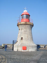
| Berry Head
latitude 50° 23' 58.5" N longitude 3° 29' 0.4" W
Celebrated as England's smallest lighthouse (it looks more like 3m in photos), this is nonetheless a major seacoast light. Located at the end of Gillard Road in Brixham. From Brixham, follow Berry Head Road East to the Light. (A 0244) ARLHS # ENG-007
Photo courtesy Gordon McKinlay [Flickr] |
EN 113
[EN48A] |
Brixham Pier
latitude 50° 24' 20" N longitude 3° 30' 46.5" W
At the end of Victoria Breakwater (a pier 1/2 mile long) (A 0246) ARLHS # ENG-016
Photo courtesy Gordon McKinlay [Flickr] |
|
EN 114
[EN48L] |
| Phillip Lucette Beacon
latitude 50° 32' 19.7" N longitude 3° 29' 55.4" W
Not a lighthouse, but obviously a venerable beacon. Located on the south side of the entrance to the Teign, off Marine Parade in Shaldon. (A 0263)
Photo courtesy Alexander Trabas [ListOfLights] |
EN 115
[EN48T] |
Teignmouth (The Den)
latitude 50° 32' 26.1" N longitude 3° 29' 59.4" W
The lighthouse also functions as the front light of a range; the rear light is mounted on a black post much like a streetlight. Located on the quay at Den Point on the Teignmouth waterfront. rear (A 0262) ARLHS # ENG-153
Photo courtesy Dorthy Dawson [pictures] |
|
EN 116
[EN49] |
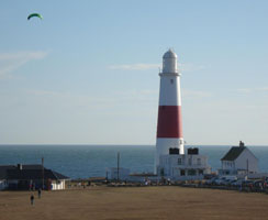
| Portland Bill
latitude 50° 19' 43" N longitude 2° 27' 18" W
The light station is accessible by buses from Weymouth. (A0294) ARLHS # ENG-274
Photo courtesy Simon Davies (all rights reserved) |
EN 119
[EN49P] |
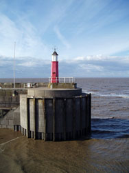
Portland Breakwater
latitude 50° 35' 47.5" N longitude 2° 26' 0.3" W |
it is the only active survivor in England of a type of prefabricated lighthouse that was once quite common. Located at the south end of the northeast breakwater of Portland Harbour, one of three breakwaters that encircle the harbor. ARLHS # ENG 344 |
EN 120
[EN50] |
Anvil Point
latitude 50° 35' 41.7" N longitude 1° 57' 7.5" W
Located atop a cliff in Durlston County Park, at the end of Lighthouse Road about 3 km south of Swanage. (A 0496) ARLHS # ENG-001
Photo courtesy Photo Paul [Flickr] |
|
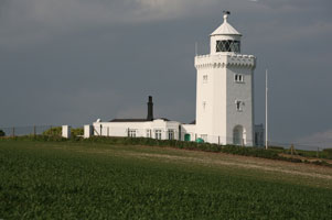
EN 121
[EN53] |
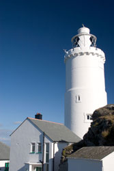
| St. Catherines
latitude 50° 34' 32.4" N longitude 1° 17' 52" W
is situated at Niton Undercliffe, 5 miles from Ventnor on the Isle of Wight. (A 0774)
Photo courtesy lostajy [Flickr] |
EN 122
[EN47Q] |
St. Catherine's Breakwater |
This lighthouse was originally on a breakwater near the northeastern tip of Jersey. It has been relocated for display outside the entrance to the Jersey Maritime Museum. Located on the North Quay at St. Helier. |
EN 123
[EN51] |
Needles
latitude 50° 39' 44.5" N longitude 1° 35' 28.8" W
Set in the western approaches to the Isle of Wight, the Needles form a narrow chalky peninsula which rises from jagged rocks to 120m cliffs. (cropped to emphasize the light) (A 0528) ARLHS # ENG-083
Photo courtesy John Linwood [Flickr] |
|
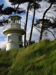
EN 124
[EN52] |
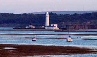
| Hurst Point High (1867)
Hurst Point Lighthouse guides vessels through the hazardous western approaches to the Solent, indicating the line of approach through the Needles Channel. (There are additional views in the same album as this photo.) (A 0538.1) ARLHS # ENG-057
Photo courtesy sparijs [webshots] |
|
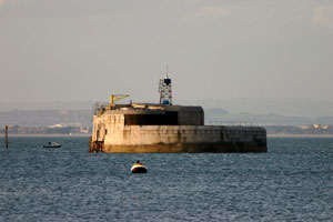
|
EN 125
[EN52C] |
Hurst Point Low (1866) (Hurst Castle) |
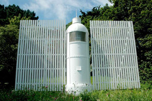
Circular granite tower built on the walls of Hurst Castle (1544). Located at the end of a narrow spit extending into the Solent south of Keyhaven. ARLHS # ENG-058 |
EN 127
[EN52G] |
Beaulieu River (Millennium Beacon)
latitude 50° 47' 7.2" N longitude 1° 21' 53.2" W
This lighthouse was built as a Millennium project by the town of Beaulieu. Located on the north side of the entrance to the Beaulieu River from the Solent, about 3 km southeast of Exbury. (A 0553.15) ARLHS # ENG-277
Photo courtesy day 7 [Flickr] |
|
EN 128
[EN54E] |
Egypt Point
latitude 50° 46' 2.3" N longitude 1° 18' 49.9" W |
Located at the northernmost point of the Isle of Wight, on the waterfront in Cowes. ARLHS # ENG-180 |
EN 129
[EN54F] |
St. Helen's Fort
Located about 1.5 km off St. Helens and 7 km south of Southsea. Accessible only by boat. (A 0760) ARLHS # ENG-181
Photo courtesy Alexander Trabas [ListOfLights] |
|
EN 131
[EN52N] |
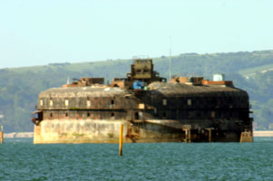
No Man's Land Fort |
Located on the left side of the Portsmouth entrance channel about 4 km south of Southsea. Accessible only by boat. (A 0752) ARLHS # ENG-237 |
EN 133
[EN54A] |
Southsea Castle
latitude 50° 46' 41.1" N longitude 1° 5' 20" W
East side of the entrance to Portsmouth Harbour. The light is mounted on the north corner of the castle. (A 0691) ARLHS # ENG-134
Photo courtesy Mallmus [Flickr] |
|
EN 134
[EN52T] |
| Spitbank Fort
latitude 50° 46' 13.9" N longitude 1° 5' 57" W
The fort is a privately owned tourist attraction. Located in the harbor entrance about 1 km off Southsea. (A 0688)
Photo courtesy Alex Trabas [liteslist] |
EN 135
[EN52S] |
Horse Sand Fort
Located on the right side of the Portsmouth entrance channel about 3.5 km south of Southsea. Accessible only by boat. (A 0750) ARLHS # ENG-225
Photo courtesy Alex Trabas [liteslist] |
|
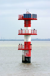
EN 136
[EN54] |
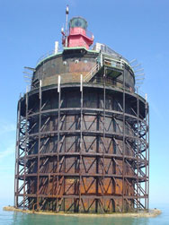
| Nab Tower
Located in the English Channel southeast of Bembridge, just off the eastern end of the Isle of Wight. (A 0780) ARLHS # ENG-082
Photo courtesy DJ Stoker [Flickr] |
EN 137
[EN54L] |
Littlehampton East Pier Range Rear
latitude 50° 48' 17.2" N longitude 32' 34.7" W
Located near the foot of the pier, at the end of Pier Road, on the Littlehampton waterfront. (A 0801.1) ARLHS # ENG-066
Photo courtesy supermoving [Flickr] |
|
EN 138
[EN54M] |
| Shoreham Middle Pier Range Front
latitude 50° 49' 44.9" N longitude 14' 52.6" W
Located at the end of the middle pier at Shoreham-by-Sea, about 8 km west of Brighton. (A 0814) ARLHS # ENG-313
Photo courtesy Alex Trabas [liteslist] |
EN 140
[EN54S] |
| Newhaven Breakwater
latitude 50° 46' 33.1" N longitude 3' 30.1" E
Located at the end of the long breakwater on the west side of the harbor of Newhaven. Accessible by walking the breakwater, which is popular for fishing and sightseeing. (A 0830) ARLHS # ENG 086
Photo courtesy Alexander Trabas [ListOfLights] |
EN 141
[EN54T] |
Newhaven East Pier
latitude 50° 46' 48.6" N longitude 3' 35.2" E
This little lighthouse was demolished in early 2006 and replaced by a modern post light. This light was located at the end of the east pier of Newhaven. Not to be confused with another Newhaven East Pier Light on the Firth of Forth in Edinburgh, Scotland. SC68C (A 0832) ARLHS # ENG-235
Photo courtesy Alex Trabas [ListOfLights] |
|
EN 142
[EN54V] |
Belle Tout
latitude 50° 44' 19.3" N longitude 13' 12.9" E |
Located off Beachy Head Road about 6 km southwest of Eastbourne. ARLHS # ENG-006 |
EN 143
[EN55] |
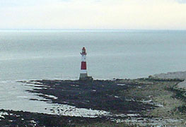
Beachy Head
latitude 50° 44' 1.5" N longitude 14' 29.2" E
Along the cliffs (known as Dover Cliffs in the US) 3 miles from Eastborne, Sussex.
From Eastbourne, follow King Edward's Parade and Upper Dukes Dr. SE until you get to Beachy Head Road. Follow that 1.6 miles to the point. (A 0840) ARLHS # ENG-005
Photo courtesy Simon Davies [Flickr] |
|
EN 145
[EN56H] |
Hastings Range Rear
latitude 50° 51' 29.5" N longitude 35' 23.3" E
Located on West Hill, off West Hill Road, on the west side of town. (A 0858.1) ARLHS # ENG-285
Photo courtesy Alex Trabas [liteslist] |
|
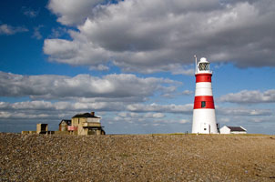
EN 146
[EN56O] |
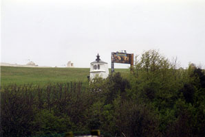
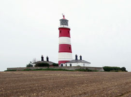
Dungeness (1792)
latitude 50° 54' 41.7" N longitude 58' 16.6" E |
Dungeness Point is the western entrance to the Strait of Dover; it is a broad wedge of land that continuously extends itself into the Channel, making it necessary from time to time to build new lighthouses closer to the end of the point. Located about 600 m west of the point. ARLHS # ENG-343 |
EN 147
[EN57] |
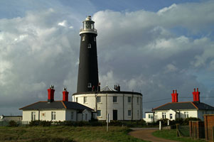
Dungeness (1904)
latitude 50° 54' 49.5" N longitude 58' 11" E
The southernmost point in Kent. Located about 450 m west of the point. Accessible by road and by railroad from Romney ARLHS # ENG-038
Photo courtesy Nick Garrod [Flickr] |
|
EN 148
[EN57A] |
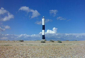
| Dungeness (1961)
latitude 50° 54' 48.4" N longitude 58' 33.4" E
The light above is now out of service. This is its replacement. (A 0876) ARLHS # ENG-085
Photo courtesy Dan Kell [Flickr] |
EN 149
[EN57C] |
Folkestone Pier
latitude 51° 4' 33.6" N longitude 1° 11' 41.7" E
Located at the end of the New Pier in Folkestone (pier is not open to the public). (A 0892) ARLHS # ENG-341
Photo courtesy Philip Moore [Flickr] |
|
EN 151
[EN57F] |
Admiralty Pier
latitude 51° 6' 40.8" N longitude 1° 19' 39.7" E
Located at the end of the pier, which extends 1220 m west to east enclosing the western side of Dover Harbour. (A 0900)
Photo courtesy doverpast [doverpast] |
|
EN 152
[EN57H] |
| Prince of Wales Pier
latitude 51° 6' 50.7" N longitude 1° 19' 22.4" E
Located at the end of the pier, which separates the outer and inner harbors at Dover. (A 0902) ARLHS # ENG-214
Photo courtesy doverpast [doverpast] |
EN 153
[EN57K] |
Dover Breakwater West End
latitude 51° 6' 47.2" N longitude 1° 19' 47.8" E
This lighthouse and the Admiralty Pier Light bracket the western entrance to Dover Harbour. (A 0924) ARLHS # ENG-294
Photo courtesy Mike Shepherd [Flickr] |
|
EN 154
[EN57D] |
Dubris Pharos |
An open fire was displayed from the top to guide ships into the harbor of Dubris, as Dover was called in Roman times. Since the twelfth century the tower has stood within the walls of Dover Castle. Located on the heights above Dover Harbour. * ARLHS # ENG 034 |
EN 156
[EN58A] |
South Foreland (High)
Up on the cliffs overlooking the English Channel. There is no access to lighthouse by car; visitors must walk from main car park (NT) situated at Langdon Cliffs (2ml) or from St Margaret’s village or bay (1ml, not NT). Alternatively park at White Cliffs property and walk around cliff tops to lighthouse, approx. 2m ARLHS # ENG-129
Photo courtesy John Linwood [Flickr] |
|
EN 157
[EN58] |
| North Foreland
latitude 51° 22' 29.4" N longitude 1° 26' 42" E
This historic lighthouse marks the beginning of the approach to the Thames estuary and the port of London. Located at the northeastern corner of Kent, 2 km north of Broadstairs. (A 0966) ARLHS # ENG-087
Photo courtesy Dr. Moore [Flickr] |
EN 158
[EN57Q] |
Ramsgate East Pier (Range Front)
The post light noted below. (A 0957) ARLHS # ENG-328
Photo courtesy Alexander Trabas [ListOfLights] |
|
EN 159
[EN57R] |
| Ramsgate West Pier (Range Rear)
latitude 51° 19' 39.6" N longitude 1° 25' 17.7" E
The front light of the range is a post light at the end of the east pier. Located at the end of the pier in Ramsgate. (A 0957.1) ARLHS # ENG-241
Photo courtesy Alexander Trabas [ListOfLights] |
EN 160
[EN58E] |
Margate Pier
latitude 51° 23' 27" N longitude 1° 22' 41.3" E
The original lighthouse was destroyed by a storm in 1953. Located at the end of the pier in Margate. (A 1972) ARLHS # ENG-079
Photo courtesy Kei Koyama [Flickr] |
|
EN 161
[EN58F] |
| Herne Bay
latitude 51° 22' 26.2" N longitude 1° 7' 15.4" E
This unusual structure is adjacent to a long pier at Herne Bay, 8 km north of Canterbury. (A 1976)
Photo courtesy Alex Trabas [liteslist] |
EN 163
[EN58H] |
| Shornmead (2004)
latitude 51° 26' 55.1" N longitude 26' 14.3" E
The light stands in the water, no longer connected to shore. Located on the south bank of the estuary near Cliffe, at the lower end of the Gravesend Reach. (A 2096) ARLHS # ENG-281
Photo courtesy Alex Trabas [liteslist] |
EN 165
[EN58K] |
Northfleet Lower |
This is the oldest of the River Thames light stations. Located on the India Arms Wharf in Northfleet, on the south side of the river. Apparently accessible by walking the wharf. ARLHS # ENG-089 |
EN 166
[EN58L] |
Blackwall (Trinity House Wharf)
Located on the Trinity Buoy Wharf in Blackwall at the entrance to Bow Creek, opposite the London Millennium Dome. It was built for lighting experiments and was never used as an aid to navigation. ARLHS # ENG-275
Photo courtesy Fin Fahey [Flickr] |
|
EN 168
[EN59E] |
Gunfleet |
Located 10 km off Frinton-on-Sea at the northern entrance to the Thames embayment. Accessible only boat. ARLHS # ENG 049 |
EN 169
[EN59F] |
Dovercourt Low
latitude 51° 56' 3.5" N longitude 1° 17' 51.2" E
Located just offshore at Dovercourt, a town on the south side of Harwich; easily visible from the promenade. ARLHS # ENG-037
Photo courtesy Mocosito [Flickr] |
|
EN 170
[EN59G] |
| Dovercourt High
latitude 51° 56' 14.5" N longitude 1° 17' 25.4" E
Located on the beach, near the seaside promenade at Dovercourt, on the south side of Harwich. ARLHS # ENG-215
Photo courtesy mole-volio [Flickr] |
EN 173
[EN60A] |
Harwich
It's likely this is a radar or weather tower as it's not listed as a light. ARLHS # ENG-053
Photo courtesy sparijs [webshots] |
|
EN 174
[EN60] |
| Orfordness
in Suffolk, is situated at the end of a 13 mile spit which runs parallel to the coast. The lighthouse is on an old military testing site which is now owned by the National Trust and you can find more info here
Located about 5 km southeast of Orford; accessible by passenger ferry and hiking trail. ARLHS # ENG-096
Photo courtesy Keith Marshall [Flickr] |
EN 175
[EN61] |
Southwold
latitude 52° 19' 38.3" N longitude 1° 40' 52.5" E
Situated near the centre of the seaside resort of Southwold, midway between Lowestoft and Orford. It is set a block or two back from the seafront in the middle of town! (A 2272) ARLHS # ENG -35
Photo courtesy Simon Davies (all rights reserved) |
|
EN 177
[EN61Q] |
Lowestoft South Pier
latitude 52° 28' 17.4" N longitude 1° 45' 21.6" E
Located on the end of the stone pier marking the narrow entrance to the harbor of Lowestoft (A 2284) ARLHS # ENG-264
Photo courtesy Alexander Trabas [ListOfLights] |
|
EN 180
[EN62G] |
| Gorleston South Pier
The present lighthouse was presumably built as a harbormaster's office, but it is now a Coastwatch station. Located at the end of the south pier in Gorleston, the seaport on the south side of Great Yarmouth. (A 2304) ARLHS # ENG-221
Photo courtesy Alexander Trabas [ListOfLights] |
EN 181
[EN62H] |
Gorleston (Range Rear)
The River Yare makes a right-angle bend to the east just before reaching the sea, and this lighthouse stands by the bend displaying its light through the river mouth. Located at the end of Pier Road in Gorleston. ARLHS # ENG-303
Photo courtesy Robin Knight [Flickr] |
|
EN 182
[EN62J] |
Winterton
latitude 52° 43' 3.4" N longitude 1° 41' 54.9" E |
The lighthouse and keeper's house are a private residence. Located in Winterton-on-Sea, a fishing town and seaside resort about 10 km north of Great Yarmouth. ARLHS # ENG-310 |
EN 183
[EN62K] |
Happisburgh (High)
latitude 52° 49' 13.8" N longitude 1° 32' 13" E
Located in Happisburgh, a seaside village on the shoulder of Norfolk, about 25 km northeast of Norwich. It is the only privately operated lighthouse in the UK. (A 2336) ARLHS # ENG -050
Photo courtesy smagdali [Flickr] |
|
EN 184
[EN63] |
| Cromer
latitude 52° 55' 28.7" N longitude 1° 18' 59.2" E
The light station is about 400 m from the cliffs overlooking the North Sea. These cliffs are subject to rapid beach erosion, and the original lighthouse was lost to erosion in 1866. Located on a high point above the cliffs east of Cromer, a town about 30 km north of Norwich. (A 2342) ARLHS # ENG-028
Photo courtesy icerunner [Flickr] |
EN 185
[EN64] |
Hunstanton
The light stands at the southern entrance to The Wash, the U-shaped bay between Norfolk and Lincolnshire. Located on Lighthouse Lane on the north side of Hunstanton, a town about 30 km north of King's Lynn. ARLHS # ENG-056
Photo courtesy stevec77 [Flickr] |
|
EN 187
[EN64Q] |
Spurn Point High
Spurn Point is a spit curving out into the northern side of the entrance to the Humber. Located near the end of the spit, accessible by an easy hike of several miles. ARLHS # ENG-138
Photo courtesy wsogmm [Flickr] |
|
EN 188
[EN64N] |
Spurn Point High (1767)
latitude 53° 34' 48" N longitude 6' 36" E |
ARLHS # ENG-137 |
EN 189
[EN64M] |
Spurn Point Low
Apparently this light was the front light of a downbound range. Located just offshore on the river side of the Spurn Point spit. It's now a water tower, that's why the top looks unusual. ARLHS # ENG-139
Photo courtesy Jason Gillyon [Flickr] |
|
EN 191
[EN64G] |
Killingholme North Low
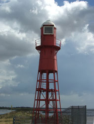
latitude 53° 38' 54.6" N longitude 12' 33.9" W |
Formerly in poor condition, this lighthouse was restored in 2003 as a private residence. Located on the south bank of the Humber at Killingholme. ARLHS # ENG-061 |
EN 193
[EN64K] |
| Thorngumbald Clough Low
latitude 53° 42' 31.7" N longitude 13' 36.8" W
These lights replaced the Paull Light after a shift in the river channel. Located on the north bank of the Humber a short distance below Paull. (A 2506) ARLHS # ENG-177
Photo courtesy Steve Roe [Flickr] |
EN 194
[EN64J] |
Paull
latitude 53° 43' 8.1" N longitude 14' 3.8" W
Located on the north bank of the Humber at Paull (corner of Town End Rd and Anson Villas), about 8 km below Hull. ARLHS # ENG-099
Photo courtesy Steve Roe [Flickr] |
|
EN 195
[EN64H] |
| Whitgift No 8
latitude 53° 41' 55.8" N longitude 45' 27" W
Located on the south bank of the Ouse about 10 km below Goole. (A 2571.9) ARLHS # ENG-309
Photo courtesy Alexander Trabas [ListOfLights] |
EN 196
[EN65A] |
Flamborough (1669)
This remarkably well preserved seventeenth century tower is unique in England. It was designed as a lighthouse, but there is no evidence it was ever lit, it served for more than a century as a daybeacon. ARLHS # ENG 247
Photo courtesy Karen Turner [Flickr] |
|
EN 197
[EN65] |
| Flamborough (1806)
latitude 54° 6' 59" N longitude 4' 57.3" W
The old lighthouse can just be seen on the right side of this photo.
Located on a rocky point jutting into the North Sea about 10 km northeast of Bridlington. (A 2582) ARLHS # ENG 042
Photo courtesy Photo Paul [Flickr] |
EN 198
[EN65S] |
Scarborough Pier
latitude 54° 16' 54.6" N longitude 23' 24" W
Located on a pier in the old harbor at Scarborough; the pier's original name is St. Vincent's Pier but it is usually called Lighthouse Pier. (A 2592) ARLHS # ENG-121
Photo courtesy Alex Trabas [ListOfLights] |
|
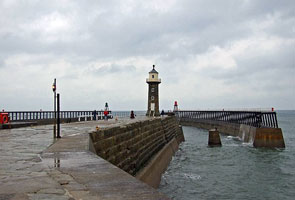
EN 200
[EN66] |
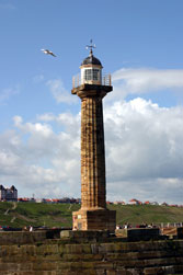
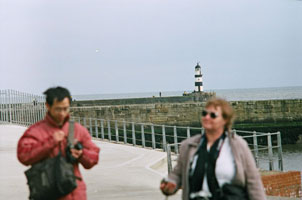
| Whitby High (Ling Hill)
latitude 54° 28' 45.7" N longitude 34' 14.7" W
On Ling Hill between Whitby and Robin Hood Bay. (A 2596) ARLHS # ENG-164
Photo courtesy Juan J. [Flickr] |
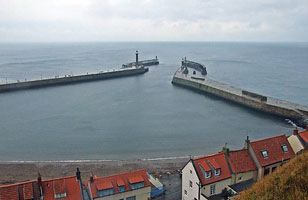
EN 203
[EN66A] |
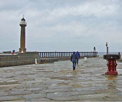
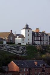
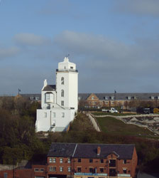
Whitby West Pier (1831)
latitude 54° 29' 34.2" N longitude 36' 46.5" W
On the Harbor wall at Whitby.
Photo courtesy Royston Vasey [Flickr] |
|
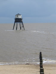
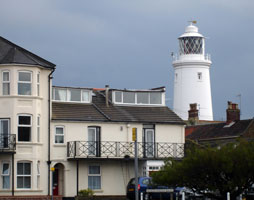
EN 205
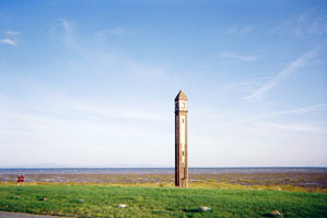
[EN66E] |
South Gare
latitude 54° 38' 50.6" N longitude 1° 8' 15" W
Located at the end of the stone pier at the entrance to the River Tees about 8 km west of Redcar. (A 2626) ARLHS # ENG-131
Photo courtesy David Roberts [Flickr] |
|
EN 206
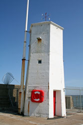
[EN66F] |
Seaton High (Seaton Tower)
latitude 54° 41' 29.6" N longitude 1° 12' 8" W |
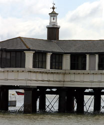
The lighthouse formerly stood at Seaton Carew southeast of Hartlepool. It was taken down and rebuilt as a war memorial during the redevelopment of the Hartlepool waterfront. Located at the end of the pier at the Hartlepool Marina in downtown Hartlepool. ARLHS # ENG-332 |
EN 207
[EN66G] |
Hartlepool Old Pier
latitude 54° 41' 36.2" N longitude 1° 11' 17.2" W
Located at the end of the pier on the south side of the entrance to the old harbor at Hartlepool. (A 2664) ARLHS # ENG-305
Photo courtesy Stuart Graham [Flickr] |
|
EN 208
[EN66H] |
| The Heugh (Hartlepool Headland)
latitude 54° 41' 35.9" N longitude 1° 11' 5.6" W
Located on the headland known as the Heugh, sheltering Hartlepool Harbour, on the north side of the city. (A 2663) ARLHS # ENG-154
Photo courtesy Tony Readman [Flickr] |
EN 210
[EN66K] |
| Roker Pier (Sunderland North Pier)
latitude 54° 55' 16.7" N longitude 1° 21' 9" W
Located at the end of the pier on the north side of the entrance to the River Wear in Sunderland. (Don't confuse with North Sunderland) EN225 (A 2681) ARLHS # ENG-116
Photo courtesy Rick Frame [Flickr] |
EN 211
[EN66L] |
Sunderland South Pier
latitude 54° 55' 52.4" N longitude 1° 21' 58.1" W
When the pier was shortened in 1983, the lighthouse was relocated to a site overlooking the sea in Roker Cliff Park. Located off Whitburn Road on the north side of Sunderland. (A 2682) ARLHS # ENG-244
Photo courtesy Mark Wood (UK) [Flickr] |
|
EN 212
[EN66M] |
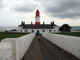
| Souter
latitude 54° 58' 13.8" N longitude 1° 21' 50.8" W
Located on Marsden Head off the coastal road about 5 km north of Sunderland. ARLHS # ENG-127
Photo courtesy Biepmiep [Flickr] |
EN 213
[EN66N] |
Tyne South Pier
latitude 55° 40.3" N longitude 1° 24' 4" W
Located at the end of the mile-long south pier at the entrance to the River Tyne in South Shields. (A 2702) ARLHS # ENG-158
Photo courtesy Riverman72 [Flickr] |
|
EN 214
[EN66P] |
| Herd Groyne
latitude 55° 28.8" N longitude 1° 25' 26.8" W
Located at the end of the groin on the south side of the Tyne in South Shields. Accessible in good weather by walking the groin. (A 2702.5) ARLHS # ENG-330
Photo courtesy Joke [mylights] |
EN 215
[EN66Q] |
Tynemouth (Tyne North Pier)
Located at the end of the north pier at the entrance to the River Tyne in North Shields. (A 2700) ARLHS # ENG-159
Photo courtesy Biepmiep [Flickr] |
|
EN 217
[EN66S] |
Fish Quay Low
latitude 55° 32.8" N longitude 1° 26' 3.9" W
Located on Fish Quay on the waterfront of North Shields. ARLHS # ENG-300
Photo courtesy Joke [mylights] |
|
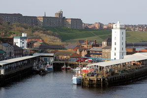
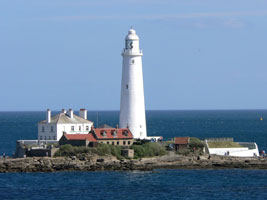
EN 219
[EN66U] |
St. Mary's
latitude 55° 4' 18.1" N longitude 1° 26' 58.2" W
Reached between the tides via a short causeway, St Mary’s Lighthouse has all the fascination of a miniature, part-time island. The Lighthouse, completed in 1898, on a hazardous coast for shipping, remained operational until 1984 when it was superseded by modern navigational techniques. You'll find it just east of Whitley Bay. (A 2043.31)
Photo courtesy MoeMac [Flickr] |
|
EN 220
[EN66V] |
Blyth East Pier (Blyth Harbour)
latitude 55° 6' 59.4" N longitude 1° 29' 12.1" W
Located on the pier head at Blyth, about 20 km northeast of Newcastle Upon Tyne. (A 2754) ARLHS # ENG-013
Photo courtesy Glen Bowman [Flickr] |
|
EN 222
[EN66Y] |
Blyth High
latitude 55° 7' 31.8" N longitude 1° 30' W
Located on Bath Terrace, just above the Quay in downtown Blyth. When it was built in 1788 it was only about ten meters from the shoreline. It was raised in height in 1888 and 1900. (A 2766.1) ARLHS # ENG-283
Photo courtesy MickDonnelly Photo [Flickr] |
|
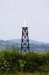
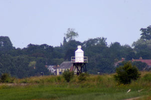
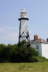
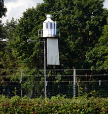
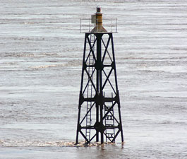
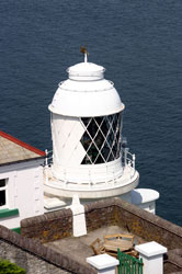
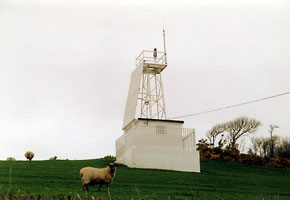
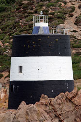
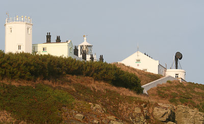
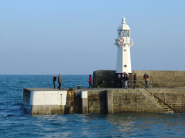
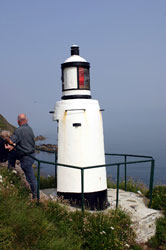
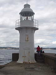
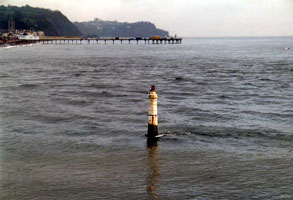
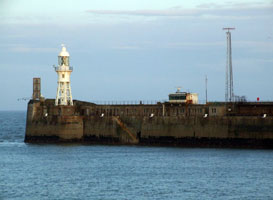
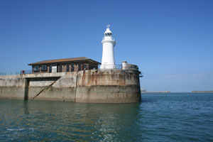
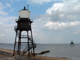
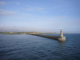
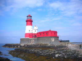
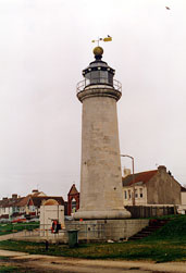
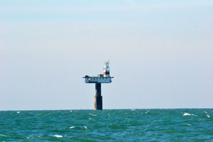
EN 223
[EN67] |
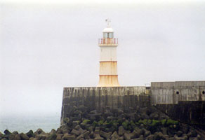
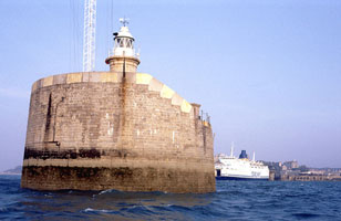
| Coquet
latitude 55° 20' 2.3" N longitude 1° 32' 21.9" W
Coquet Island is a small low tract of green pastureland lying close inshore off the Northumberland coast (A 2780) ARLHS # ENG-025
Photo courtesy Steve Wilde [Flickr] |
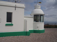
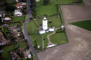
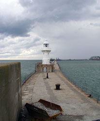
EN 224
[EN67P] |
Warkworth South Pier (Amble South Pier)
latitude 55° 20' 20.4" N longitude 1° 34' 14.9" W
The light marks the entrance to the River Coquet at Amble; Warkworth is a town about 2.5 km upstream. Located at the end of the south pier. (A 2784) ARLHS # ENG-179
Photo courtesy Flickr] |
|
EN 225
[EN67S] |
| North Sunderland (Seahouses)
latitude 55° 35' 1.7" N longitude 1° 38' 56.4" W
Located at the end of the pier on the west side of the entrance to Seahouses Harbour in North Sunderland. (Don't confuse with Roker Pier) EN210 (A 2804) ARLHS # ENG-258
Photo courtesy Roger Cave [Flickr] |
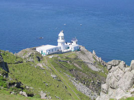
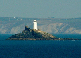
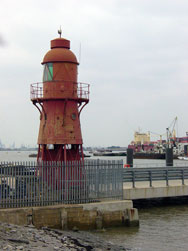
EN 226
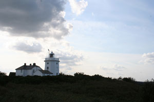
[EN68] |
Farne
latitude 55° 36' 55.3" N longitude 1° 39' 20.7" W
Off the coast of Northumberland lies a little archipelago of islands which takes it name from Farne, the largest and nearest to the land (A 2812) ARLHS # ENG-060
Photo courtesy © Martin Brewster [Flickr] |
|
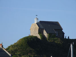
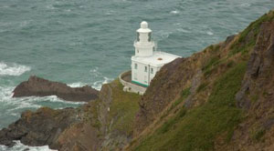
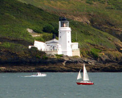
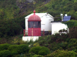
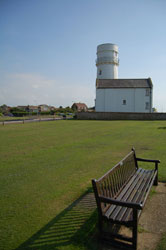
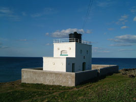
EN 227
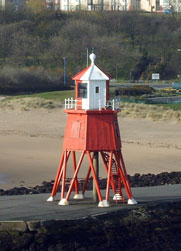
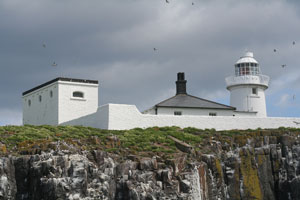
[EN69] |
| Longstone
latitude 55° 38' 37.7" N longitude 1° 36' 39.1" W
is situated on Longstone Rock, one of the Outer Staple Islands This is the light where Grace Darling performed her legendary rescue. rescue (A 2814) ARLHS # ENG-070
Photo courtesy MG Spiller [Flickr] |
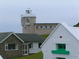
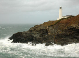
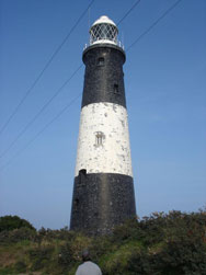
EN 228
[EN70] |
Bamburgh
latitude 55° 36' 59.6" N longitude 1° 43' 26.9" W
The original lighthouse, a round iron skeletal tower, was demolished in 1975 and the light moved to the roof of the original service building. Located on the rocky shore at Black Rock Point about 1.6 km east of Bamburgh. (A 2810) ARLHS # ENG-004
Photo courtesy Mark Dodds [Flickr] |
|
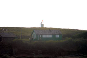
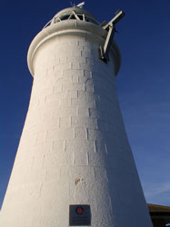
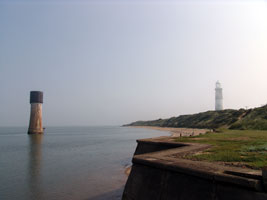
EN 230
[EN72] |
Guile Point East
latitude 55° 39' 28.8" N longitude 1° 47' 42" W
This obelisk and the nearby Guile Point West (a small framework tower) marks the southeastern entrance to the harbor of Holy Island, which is just off the mainland southeast of Berwick Upon Tweed.
Located on the mainland about 5 km northeast of Detchant. (A 2816) ARLHS # ENG-222
Photo courtesy Chris Barker [Flickr] |
|
EN 231
[EN72B] |
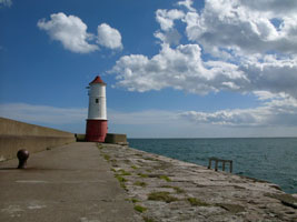
| Berwick Upon Tweed Breakwater
latitude 55° 45' 53.2" N longitude 1° 59' 3.1" W
Berwick Upon Tweed is the northernmost town in England, right on the border of Scotland. Located at the end of the breakwater at the northern entrance to the River Tweed. (A 2818) ARLHS # ENG-173
Photo courtesy Ian Dolphin [Flickr] |
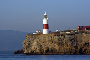
EN 232
[EN73] |
Europa Point
latitude 36° 6' 34.9" N longitude 5° 20' 41.6" W
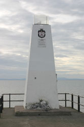
November 9, 2007
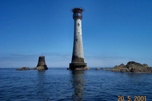
This is at the southern most point of Gibraltar. We arrived at 8:00 AM and captured this lovely picture from the deck of Le Diamant. (D 2438) ARLHS # GIB-001 |
|
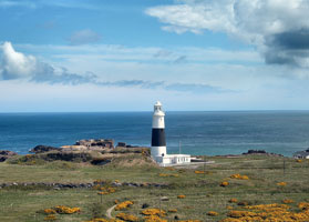
|
|
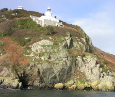
 Ireland
 Scotland
![[Les] Casquets](UK/England/LesCasquets.jpg)
