|
This page currently shows the Lighthouses of Wales. Some of the photos below are available on Webshots, some of the are on FLICKR, in any case, you can click on the light to go to it's specific (larger resolution) copy. Each lighthouse name is linked to (in our editorial opinion) the best reference site for that light. |
|
| WL 1 |
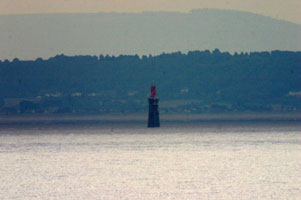
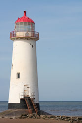
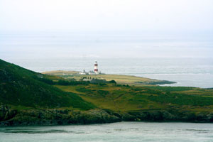
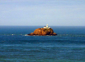
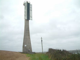
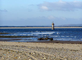
Point of Ayr (Talacre)
latitude 53° 21' 25.1" N longitude 3° 19' 20.2" W
Though long abandoned, this lighthouse has been maintained in fairly good condition. The lighthouse is surrounded by water at high tide, but it can be reached easily across a broad, flat beach when the tide is low. Located on the beach about 1 km west of Point of Ayre. Accessible by walking about 800 m from Talacre, a short distance off the A548 coastal highway. ARLHS # WAL-018
Photo courtesy Sally [Flickr] |
|
| WL 2 |
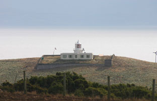
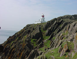
Great Orme (Llandudno)
latitude 53° 20' 32.3" N longitude 3° 52' 8.2" W |
This remarkable lighthouse is perched high on a vertical cliff at the northern end of the promontory.
Located on Marine Drive (a toll road) about 5 km northwest of Llandudno. MarineDrive ARLHS # WAL-008 |
| WL 3 |
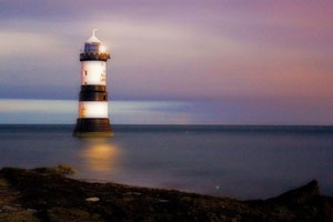
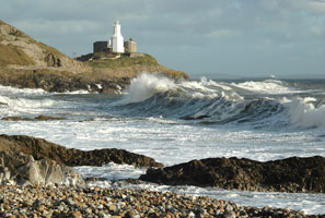
Trwyn Du
latitude 53° 18' 46.6" N longitude 4° 2' 26.5" W
The lighthouse stands at the northeastern corner of the Isle of Anglesey marking the northern entrance to Menai Strait, which separates the island from the Welsh mainland. Located just off the point of Trwyn Penmon about 3/4 mile northeast of Penmon. It is possible to walk to the lighthouse at low tide. (A 5140) ARLHS # WAL-031
Photo courtesy abstractEffects [Flickr] |
|
| WL 4 |
| Point Lynas
latitude 53° 24' 58.1" N longitude 4° 17' 21.9" W
The original lighthouse was 300 m to the south. Like Great Orme, the light station was built by the Mersey Docks and Harbour Board and transferred to Trinity House in 1973. Located on Point Lynas, about 1 km north of Llaneilian. (A 5160) ARLHS # WAL 019
Photo courtesy lostajy [Flickr] |
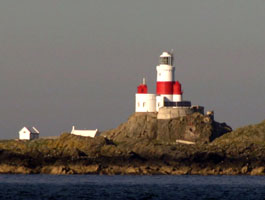
| WL 5 |
The Skerries
latitude 53° 25' 16.1" N longitude 4° 36' 30.5" W
June 8, 2005
At the end of a low tract of submerged land North-East of Holyhead (A 5168) ARLHS # WAL 030 |
|
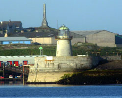
| WL 6 |
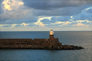
| Holyhead Breakwater
June 8, 2005
Our tour ship was in the harbor in an awkward position. So it literally backed up to this point, did a U-turn (we came down the left channel, used the right channel for a 3-point turn) right around this light. (A 5174) ARLHS # WAL-011 |
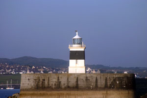
| WL 7 |
Holyhead Mail Pier
latitude 53° 18' 51.1" N longitude 4° 37' 14.2" W
June 8, 2005
Located at the end of the pier at Salt Island, marking the north side of the entrance to the Old Harbour in downtown Holyhead. |
|
| WL 8 |
| Amlwch Old Harbour
latitude 53° 24' 55.2" N longitude 4° 19' 59" W
Located at the end of the short pier enclosing the old harbor at Amlwch Port in northwestern Anglesey. (A 5164.4) ARLHS # WAL-055
Photo courtesy Alex Trabas [liteslist] |
| WL 8A |
Amlwch Inner Breakwater
latitude 53° 24' 58.4" N longitude 4° 19' 54.7" W (A 5164.5)
Photo courtesy Alex Trabas [listOfLights] |
|
| WL 9 |
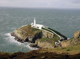
| South Stack
latitude 53° 18' 24.3" N longitude 4° 41' 58.2" W
Situated near the north west tip of Wales, the tiny islet known as South Stack Rock lies separated from Holyhead Island by 30 metres of turbulent sea. (A 5204) ARLHS # WAL 025
Photo courtesy John Jones [Flickr] |
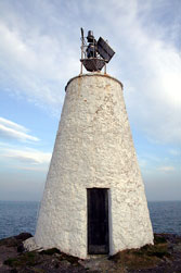
| WL 10 |
Llanddwyn Island (1800s) (Twr Bach)
latitude 53° 8' 3.4" N longitude 4° 24' 46.1" W
Llanddwyn Island is actually a peninsula except at the highest tides--is on the south shore of Anglesey about 5 km west of the southern entrance to Menai Strait. The island is accessible by popular hiking trails. Located at the southern tip of the peninsula. * (A 5210) ARLHS # WAL-046
Photo courtesy Ian Wright [listOfLights] |
|
|
|
| WL 11 |
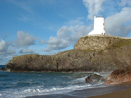
| Llanddwyn Island (1845) (Twr Mawr)
latitude 53° 8' 6.7" N longitude 4° 24' 55.7" W
In 2004 the light station appeared in the movie Half Light, starring Demi Moore; it appears the tower was repainted for the movie. Located at the southern tip of the peninsula, a short distance east of the active beacon. ARLHS # WAL 057
Photo courtesy Andrew N. Murgatroyd [Flickr] |
| WL 12 |
Bardsey
latitude 52° 44' 59.4" N longitude 4° 47' 59.8" W
The small island of Bardsey separated from the mainland by the Bardsey Sound.
(Looking out onto Bardsey Island from Braich Y Pwll in North Wales. (A 5234) ARLHS # WAL 001
Photo courtesy Sally [Flickr] |
|
| WL 13 |
| St. Tudwal's
latitude 52° 47' 54.1" N longitude 4° 28' 16.6" W
Located on St. Tudwal's Island West, at the western entrance to Tremadoc Bay about 5 km southeast of Abersoch. Accessible only by boat. (A 5238) ARLHS # WAL-028
Photo courtesy Alex Trabas [listOfLights] |
| WL 14 |
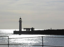
Fishguard North Breakwater
latitude 52° 45.9" N longitude 4° 58' 13.2" W
Located at the end of the breakwater in Goodwick, on the north side of Fishguard Harbour. Good views from ferries connecting Fishguard with Rosslare in southeastern Ireland. ferry (A 5262) ARLHS # WAL 039
Photo courtesy Liam O'Neill [Flickr] |
|
| WL 15 |
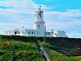
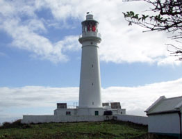
| Strumble Head
latitude 52° 1' 47.2" N longitude 5° 4' 25.9" W
stands imposingly on Ynysmeicl (St. Michael's Island), an islet to the west of Fishguard.
(heavily tweaked in Photoshop) (A 5274) ARLHS # WAL-029
Photo courtesy chalkie [Flickr] |
| WL 16 |
South Bishop
latitude 51° 51' 9.6" N longitude 5° 24' 43.3" W
Situated on a outcrop of rock in St George's Channel 4¾ miles south west of St David's Head, Pembrokeshire. (a 5276) ARLHS # WAL-024
Photo courtesy robc63 [webshots] |
|
| WL 17 |
Smalls
latitude 51° 43' 16.6" N longitude 5° 40' 11.3" W |
One of two tiny clusters of rocks lying close together in the Irish Sea, 21 miles off St. David's Head in Wales (photo) (A 5278) ARLHS # WAL 023 |
| WL 18 |
Skokholm
latitude 51° 41' 38" N longitude 5° 17' 13.1" W
The small island of Skokholm, just 1¼ miles long by ½ mile wide, lies just off the Pembrokeshire coast, and the lighthouse is situated on the South West point of the island. (A 5282) ARLHS # WAL 022
Photo courtesy dchallender [Flickr] |
|
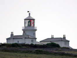
| WL 19 |
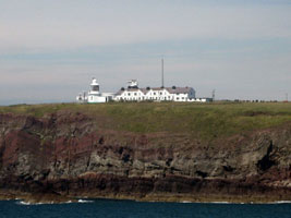
| St. Ann's Head
latitude 51° 40' 52.5" N longitude 5° 10' 25.2" W
Located at the point of St. Ann's Head in Pembrokeshire Coast National Park, marking the entrance to Milford Haven. Accessible by road. park
Note that there are two lights here. The left (front) one is the newer, the right (rear) one is the older. (A 5284) ARLHS # WAL 027
Photo courtesy Lawrence Hourahane [Flickr] |
|
|
| WL 20 |
Great Castle Head (Range Front)
Located on a promontory on the north side of Milford Haven, about 6 km west of the port of the same name. Accessible along the Pembrokeshire Coastal Path. (A 5287) ARLHS # WAL-007
Photo courtesy Alex Trabas [liteslist] |
|
| WL 21 |
Great Castle Head Rear (1870) |
The original rear light was on a 13 m stone tower. This tower was truncated to avoid confusion with the new rear light. It now seems to have been removed. ARLHS # WAL 060 |
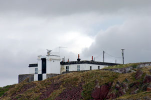
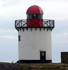
| WL 22 |
Little Castle Head (Great Castle Head Range Rear (new))
latitude 51° 43' 2" N longitude 5° 6' 35" W
Located on a promontory 890 m northeast of the front light and about 5 km west of Milford Haven. (A 5287.1) ARLHS # WAL 050
Photo courtesy Robin Lucas [geograph] |
|
| WL 23 |
| Caldey Island
latitude 51° 37' 53.6" N longitude 4° 41' 3.5" W
Caldey Island is located south of Tenby at the western entrance to Carmarthen Bay, was the site of a Benedictine monastery in medieval times and is home to a Cistercian monastery today. It is readily accessible by passenger ferries from Tenby. Located at the south point of the island. * (A 5238) ARLHS # WAL-004
Photo courtesy Sean Bolton [Flickr] |
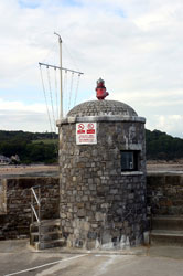
| WL 24 |
Saundersfoot South Pier
latitude 51° 42' 35.3" N longitude 4° 41' 44.8" W
Located on the pierhead in Saundersfoot. You will note that the light no longer shines through the window, but is mounted on top of the tower that was the original housing. (A 5342) ARLHS # WAL-048
Photo courtesy Alex Trabas [liteslist] |
|
| WL 25 |
| Burry Port
latitude 51° 40' 38.7" N longitude 4° 15' 4.2" W
Located on the breakwater at the harbor entrance at Burry Port on the north side of the Loughor Estuary. (A 5356) ARLHS # WAL-035
Photo courtesy Alex Trabas [liteslist] |
| WL 26 |
Whitford Point
latitude 51° 39' 9.2" N longitude 4° 15' 3.9" W
Located on Whitford Point, on the south side of the Loughor Estuary opposite Burry Port. Walking to this site requires a long hike across the Whitford Sands. ARLHS # WAL 033
Photo courtesy David Lewis [geograph] |
|
| WL 27 |
| Mumbles
latitude 51° 34' 0.5" N longitude 3° 58' 15.6" W
On the outer of two islands, known as Mumbles Head, lying about 500 yards to the E.S.E. of the mainland known as Mumbles, Swansea. (A 5358) ARLHS # WAL 016
Photo courtesy Jugoagogo [Flickr] |
| WL 28 |
Porthcawl Breakwater
latitude 51° 28' 23.2" N longitude 3° 41' 58.9" W
Long powered by gas, this little lighthouse was not converted to electric power until 1997. Located at the end of the breakwater on Porthcawl Point in Porthcawl, at the eastern entrance to Swansea Bay. (A 5402) ARLHS # WAL 036
Photo courtesy Nick Russill [Flickr] |
|
| WL 29 |
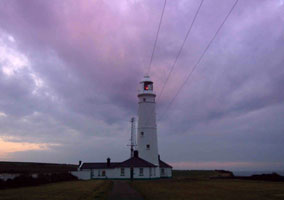
| Nash Point Low
latitude 51° 24' 3.2" N longitude 3° 33' 15.5" W
This Point marks the entrance to the narrower part of the Bristol Channel, leading to the major ports of Cardiff and Bristol. Located about 5 km west of Llanwit Major, near St. Donat's; accessible by road or by walking the coastal path from St. Donat's. ARLHS # WAL 037
Photo courtesy Steve Garrington [Flickr] |
| WL 30 |
Nash Point (High)
latitude 51° 24' 2.9" N longitude 3° 33' 7.9" W
This is between Barry and Porthcawl on the Glamorgan Coast. to mark the sandbanks off the point at the entrance to the Bristol Channel (A 5406) ARLHS # WAL-017
Photo courtesy Paul Bence [Flickr] |
|
| WL 31 |
| Barry Docks West Breakwater
latitude 51° 23' 28.3" N longitude 3° 15' 31" W
Located at the end of the breakwater at Barry, about 15 km southwest of Cardiff. ARLHS # WAL-034
Photo courtesy Dmitry Rostophshin [lightphotos] |
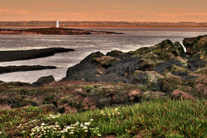
| WL 32 |
Flatholm
latitude 51° 22' 32.4" N longitude 3° 7' 7.3" W
The Island of Flatholm lies centrally in the busy shipping lanes where the Bristol Channel meets the Severn estuary. (A 5426) ARLHS # WAL-006
Photo courtesy Peter Evans [Flickr] |
|
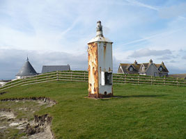
| WL 34 |
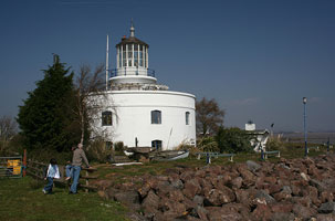
West Usk
latitude 51° 32' 26.5" N longitude 2° 59' 40.9" W
Located on the west side of the entrance to the River Usk off the B4239 about 6 km south of Newport. Site open, lighthouse open to paying guests. ARLHS # WAL 032
Photo courtesy roath_park_mark [Flickr] |
|
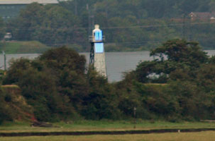
| WL 35 |
| East Usk
latitude 51° 32' 24" N longitude 2° 58' 1.2" W
Located on the east side of the entrance to the River Usk about 2 km southwest of Nash. This light is part of the Newport Westlands Reserve. (A 5454) ARLHS # WAL-005
Photo courtesy Andy South Wales [Flickr] |
| WL 36 |
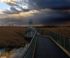
Gold Cliff
latitude 51° 31' 58.4" N longitude 2° 54' 28.1" W
An old and interesting minor aid to navigation. Located on a promontory about 2 km south of Whitson. ARLHS # WAL-056
Photo courtesy Robin Drayton [geograph] |
|
| WL 37 |
| Charston Rock (Black Rock)
latitude 51° 35' 21.1" N longitude 2° 41' 40.6" W
Located on a small island off the north shore of the Severn just east of Portskewett. Accessible only by boat, visible from a hiking trail along the river. (A 5535) ARLHS # WAL-044
Photo courtesy Terry Winter [Flickr] |
| WL 38 |
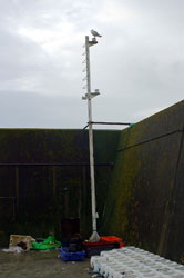
Redcliffe Range Front
latitude 51° 36' 39.4" N longitude 2° 40' 7.6" W
Originally this was the rear light of a range having the Charston Rock Light as the front light. The rear light of the modern range is on a pole 320 m north of the lighthouse. Located on the north bank of the Severn about 2.5 km southwest of Bulwark. (A 5536)
Photo courtesy Steve F [geograph] |
|
|
|

 Scotland
 Ireland