|
This page shows the documentation of the Lighthouses of Netherlands. Some of the photos below are available on webshots, some of the are on Flickr (and are reproduced with permission), and you can click on the light to go to it's specific (larger resolution) copy. Each lighthouse is linked to (in our editorial opinion) the best reference site for that light. I would like to include directions on how to get to these lights. If you know such data, could you eMail me and I'll post it here (with your choice of attribution.) mailme This page is based on the Lighthouse Directory prepared by Russ Rowlett (UNC). My thanks to him for providing this basis for understanding. lhDirectory |
|
Westerschelde South Shore
| NL 1 |
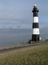
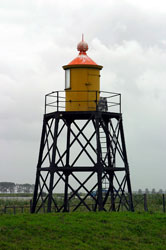
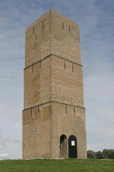
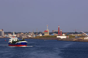
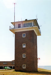
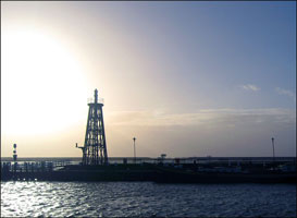
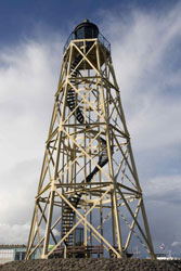
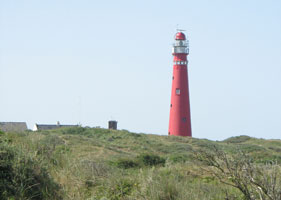
Nieuwe Sluis (Breskens) (Range Rear)
Located atop the dike at the end of the Panoramaweg in Nieuwe Sluis, west of Breskens, marking the southern entrance to the Westerschelde estuary.
Photo courtesy Nils A. Petersen [Flickr] |
|
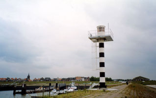
| NL 2 |
Nieuwe Sluis Range Front (Breskens) (relocated) |
The lighthouse is said to be on display in Breskens, probably at the Fishery Museum. If so, it is located on the waterfront in downtown Breskens. |
| NL 3 |
Terneuzen Veerhaven (West Harbor)
Located on the west jetty of the harbor west of Terneuzen. (B 0244)
Photo courtesy Alex Trabas [ListOfLights] |
|
Walcheren and Zuid Bevoland
| NL 4 |
Hansweert |
In 1993 it was rebuilt in what seems to be a city park; information on the site is needed. Located in Hansweert, a town on the north side of the Westerschelde about 15 km southeast of Goes. |
| NL 5 |
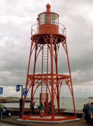
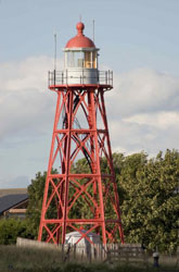
Vlissingen
latitude 51° 26' 22.4" N longitude 3° 34' 31.7" E
The pentagonal form of the base of this lighthouse is unusual; in addition, its light displays no less than 14 sectors, which might be a world record. Located on the west mole, marking the entrance to the commercial harbor (Koopmanshaven) of Vlissingen (Flushing). (B 0200)
Photo courtesy Alex Trabas [ListOfLights] |
|
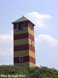
| NL 6 |
| Kaapduinen Range Front
latitude 51° 28' 29.7" N longitude 3° 30' 58.1" E
This is the front light of an upstream range for ships entering the Westerschelde. Located just off the beach on the north side of the Westerschelde, about 8 km northwest of Vlissingen. (B 0184)
Photo courtesy Christophe Boxus [Carceller] |
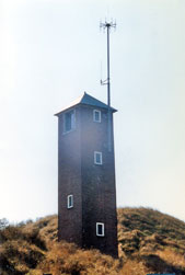
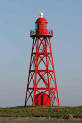
| NL 7 |
Kaapduinen Range Rear
latitude 51° 28' 23.8" N longitude 3° 31' 8.4" E
Located 220 m southeast of the front light, about 8 km northwest of Vlissingen. (B 0184.1)
Photo courtesy Christophe Boxus [Carceller] |
|
| NL 8 |
| Zoutelande (Range Front)
Located on the north shore of the Westerschelde in Zoutelande, about 8 km southwest of Westkapelle. (B 0174.1)
Photo courtesy Alex Trabas [ListOfLights] |
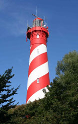
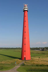
| NL 9 |
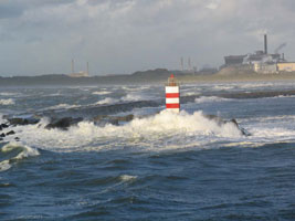
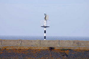
Westkapelle High (Walcheren) (Range Rear)
latitude 51° 31' 21.1" N longitude 3° 26' 27.4" E
The Noorderhooft and Zoutelande towers are placed so that they work with the high light as ranges. The church, except for the tower, burned in 1831, and since then the tower has served solely as a lighthouse. Located 1.3 km southeast of the low light in Westkapelle. (B 0174)
Photo courtesy Ellen [Flickr] |
|
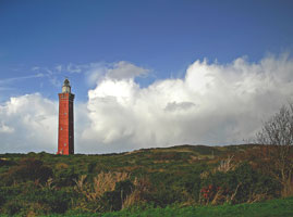
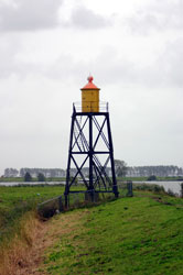
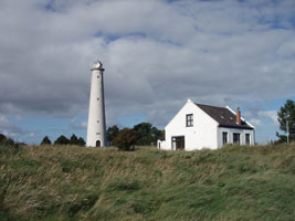
| NL 10 |
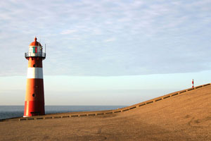
| Westkapelle Low (Noorderhoofd) (Range Front)
This light forms a range with the high light for ships at a distance approaching the Westerschelde; the red and green sectors warn nearby ships away from shoals to the south. Located just behind the sea dike at Westkapelle, at the western tip of Walcheren, marking the northern entrance to the Westerschelde.
Photo courtesy Bies [Flickr] |
| NL 11 |
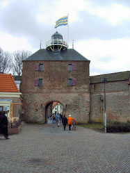
Veere |
The light guided ships on the Veerse Meer, the channel separating Walcheren from Noord Beveland. Located in Veere at the northern end of the Walcheren Kanal, which connects Vlissingin and Veere. This tower, the Campveerse Toren, was built in the late 14th century; it is now in use as an inn and restaurant and I'm looking for a photo of it. |
Schouwen, Goeree, Harlingvliet and Hollands Diep
| NL 12 |
West Schouwen (Haamstede, Westenschouwen)
latitude 51° 42' 31.8" N longitude 3° 41' 29.4" E
Schouwen is an island, separated from Walcheren by the Oosterschelde. Located behind the sea dike at Nieuw Haamstede at the westernmost point of Schouwen. Accessible by road. (B 0200)
Photo courtesy Marc de Kleijn [pBase] |
|
| NL 13 |
| Westhoofd (Ouddorp)
latitude 51° 48' 47.4" N longitude 3° 51' 50.4" E
Located near Ouddorp at the western end of Goeree-Overflakkee, an island formed when two smaller islands were joined by reclaimed land. Accessible by road. (B 0518)
Photo courtesy Ellen [Flickr] |
| NL 14 |
Goedereede
Established in 1552, inactive since 1924. Located near Ouddorp at the western end of Goeree-Overflakkee, an island formed when two smaller islands were joined by reclaimed land. Accessible by road.
Photo courtesy De Kijkdoos [Flickr] |
|
| NL 15 |
| Hellevoetsluis
latitude 51° 49' 10.9" N longitude 4° 7' 40" E
Located on the west side of the entrance to the commercial harbor of Hellevoetsluis, on the north side of the Haringvliet. (B 0536)
Photo courtesy Marc de Kleijn [pBase] |
| NL 16 |
Nieuwendijk Range Front
The Nieuwendijk range guides ships into the Vuile Gat channel north of the large island of Tiengemeten in the middle of the Haringvliet. (B 0560)
Photo courtesy Alex Trabas [ListOfLights] |
|
| NL 17 |
| Nieuwendijk Range Rear
latitude 51° 45' 11" N longitude 4° 19' 3.8" E (B 0560.1)
Photo courtesy Alex Trabas [ListOfLights] |
| NL 18 |
Willemstad
Located on the waterfront in Willemstad, overlooking the Hollands Diep, a segment of the lower Mass east of the junction of the Haringvliet and Brouwershaven, the estuaries north and south of Goeree-Overflakkee, Willemstad is off exit 23 of the A29 freeway south of Rotterdam.
Photo courtesy Marc de Kleijn [pBase] |
|
| NL 19 |
| Strijensas
This somewhat elusive lighthouse is located on the west side of the entrance to a canal, on the north side of Hollands Diep at Strijensas, about 16 km southwest of Dordrecht.
Photo courtesy Marc de Kleijn [pBase] |
Maasmond and Europoort
| NL 20 |
Brielle (Stenen Baken)
Stenen Baken simply means Brick Beacon. Located in Oostvoorne, a town west of Brielle and south of the Europoort development.
Photo courtesy Marc de Kleijn [pBase] |
|
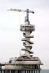
| NL 21 |
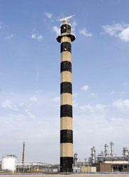
| Maasvlakte
Tallest Dutch lighthouse and one of the tallest concrete lighthouses in the world. Maasvlakte (literally, flat lands of the river Maas) is reclaimed land and the light is behind the sea dike protecting Europoort, the modern harbor constructed on the south side of the mouth of the Maas, west of Rotterdam.
Photo courtesy Marc de Kleijn [pBase] |
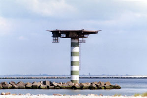
| NL 22 |
Maasmond Zuiderdam
This light and its companion (below) are popularly called paddestoelen (mushrooms), together they flank the entrance to the Rotterdamsche Waterweg, the commercial mouth of the Maas. Located at the end of the breakwater on the south side of the entrance. Accessible only by boat. NL 23 (B 0635)
Photo courtesy Alex Trabas [ListOfLights] |
|
|
|
| NL 24 |
Maasmond Low (Range Front)
latitude 51° 58' 53.2" N longitude 4° 4' 53.4" E
Located on the the Middle Pier, a long mole dividing the Rotterdamsche Waterweg from the Calandkanaal. Accessible only by boat, there are distant views from Hoek van Holland and from the end of the N15 highway in Europoort. (B 0637)
Photo courtesy Joke Reijnen [ListOfLights] |
|
| NL 25 |
| Maasmond High (Range Rear)
latitude 51° 58' 39.3" N longitude 4° 5' 48.4" E
Located on the south side of the Middle Pier. (B 0637.1)
Photo courtesy Heike + Friedrich Klatt [ListOfLights] |
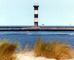
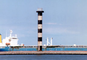
| NL 26 |
Calandkanaal Low (Europoort) (Range Front)
latitude 51° 57' 34.1" N longitude 4° 8' 42.4" E
Located near the end of a long peninsula between the Rotterdamsche Waterweg and the Calandkanaal. As you can see, accessible by car. (B 0642)
Photo courtesy Alex Trabas [ListOfLights] |
|
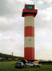
| NL 27 |
| Calandkanaal High (Europoort) (Range Rear)
latitude 51° 57' 26.5" N longitude 4° 9' 8.3" E
550 m east southeast of the low light. You can see this light in the distance above. (B 0642.1)
Photo courtesy Alex Trabas [ListOfLights] |
Hoek van Holland and Rotterdam
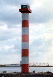
| NL 28 |
Hoek van Holland Range Front (1971)
latitude 51° 57' 54.1" N longitude 4° 8' 1" E
Located on the north side of the Rotterdamsche Waterweg, near the ferry terminal where Stena Line ferries arrive from England. Accessible by car. (B 0638)
Photo courtesy Alex Trabas [ListOfLights] |
|
| NL 29 |
Hoek van Holland Low (1899) |
In 1977 the lighthouse was cut in two and relocated to the Havenmuseum in Rotterdam. In 2005, residents of Hoek van Holland began a campaign to have the lighthouse returned to their town. Located outside the museum at Leuvehaven 1 in downtown Rotterdam.
(Range Front) (relocated) |
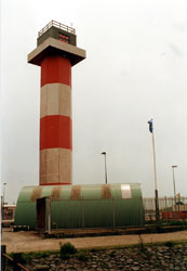
| NL 30 |
Hoek van Holland Range Rear (1974)
latitude 51° 58' 28.6" N longitude 4° 7' 55" E
Located next to the railway station in the harbour at "Hoek van Holland". It's directly on the opposite side of the entry to Rotterdam's Europort. That's 450 m (1/4 mi) east southeast of the low light. (B 0638.1)
Photo courtesy oxidser [Flickr] |
|
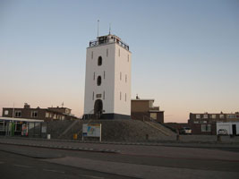
| NL 33 |
Kijkduin (Hooghe Lichtopstand replica)
latitude 52° 4' 10.5" N longitude 4° 13' 17.7" E
The municipality of The Hague decided to replace the above light with a copy made of materials that don't need so much maintenance. Located just off the waterfront in Kijkduin. (B 0858)
Photo courtesy Stephan de Prouw [Flickr] |
|
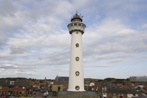
| NL 34 |
| Scheveningen
latitude 52° 6' 15" N longitude 4° 16' 5.4" E
Located at the harbor of Scheveningen, a historic port which is now the oceanfront neighborhood of The Hague, the capital of the Netherlands. (B 0750)
Photo courtesy Sculpture grrl [Flickr] |
| NL 35 |
Scheveningen Zuiderhoofd
latitude 52° 6' 13.8" N longitude 4° 15' 10.4" E
Located at the end of the south breakwater at Scheveningen (B 0751.4) |
|
| NL 36 |
Scheveningen Noorderhoofd
latitude 52° 6' 14.4" N longitude 4° 15' 22.8" E |
The entrance between the two moles is quite narrow. Located at the end of the north breakwater at Scheveningen; accessible by walking the breakwater. (B 0751.6)
Photo courtesy Marie LL [Flickr] |
| NL 37 |
Scheveningen Wandelpier (Promenade Pier)
latitude 52° 7' 4.2" N longitude 4° 16' 48.3" E
Located at the end of the pier, about 4 km north of the harbor lights. Viewers will note that this is not a lighthouse, just a interesting tower next to the water. (B 0755)
Photo courtesy Alex Trabas [ListOfLights] |
|
| NL 38 |
| Katwijk
latitude 52° 12' 1" N longitude 4° 23' 27.8" E
Located just off the seaside Zuidkant Boulevard at Secretaris Varkevissarstraat in Katwijk aan Zee.
Photo courtesy Tata Timbo [Flickr] |
| NL 39 |
Noordwijk aan Zee
Located on the Vuurtorenplein in Noordwijk aan Zee about 16 km northwest of Leiden.
Photo courtesy Hans Vink [Flickr] |
|
| NL 40 |
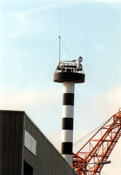
| IJmuiden Range Front
latitude 52° 27' 42.4" N longitude 4° 34' 28.6" E
Located off the Seinpostweg on the south side of the harbor entrance in IJmuiden.(A short note about syntax. The capital I, capital J means that this once was a single character. My Dutch friends indicated that the correct symbol would be a Y with an umlaut, and even my latest character set doesn't have that..) (B 0766)
Photo courtesy vunzie [Webshots] |
| NL 41 |
IJmuiden Range
latitude 52° 27' 39" N longitude 4° 34' 57.8" E
Located at the end of the Middenhavenstraat, between the two inner harbor basins of IJmuiden. (B 0766.1)
Photo courtesy François la Poutré [Flickr] |
|
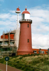
| NL 42 |

| IJmuiden Zuiderhoofd (South Breakwater)
latitude 52° 27' 43.9" N longitude 4° 33' 17.5" E
Located at the end of the south breakwater at IJmuiden. Accessible only by boat; there are good views from the foot of the breakwater. (B 0767)
Photo courtesy Conny Foto [Webshots] |
| NL 44 |
| IJmuiden Noorderhoofd (North Breakwater)
latitude 52° 28' 3.1" N longitude 4° 32' 33.3" E
Located at the end of the north breakwater at IJmuiden. (B 0768)
Photo courtesy sandra richters [Flickr] |
|
|
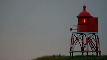
| NL 46 |
| Egmond aan Zee (van Speijk Memorial)
latitude 52° 37' 8.2" N longitude 4° 37' 18.2" E
The lighthouse was built as a memorial to Jan C. J. van Speijk (or van Speyk), who blew up his own ship to prevent it from falling into the hands of Belgian revolutionaries at Antwerp in 1831. Located on the seaside boulevard in Egmond aan Zee, about 20 km north of Ijmuiden. (B 0842)
Photo courtesy Marc de Kleijn [pBase] |
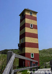
| NL 46E |
Oosterleek (Leekerhoek) |
In 2001 the old tower from 1939 was replaced with a new identical one. |
Den Helder and Den Oever Area
| NL 47 |
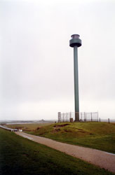
Zanddijk
Located on the dunes about 15 km southwest of Den Helder, marking the approach to the Zeegat van Texel, the historic entrance to the Zuider Zee.
Photo courtesy Marc de Kleijn [pBase] |
|
| NL 48 |
| Huisduinen
latitude 52° 57' 6.7" N longitude 4° 43' 17.7" E
Located in the village of Huisduinen, just west of Den Helder. (B 0856)
Photo courtesy Alex Trabas [ListOfLights] |
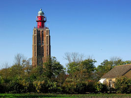
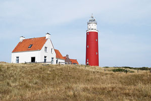
| NL 49 |
Kijkduin (Den Helder, Lange Jaap(Long John))
latitude 52° 57' 19.5" N longitude 4° 43' 35.4" E
One of the world's great lighthouses, and very possibly the tallest cast iron lighthouse in the world. (The Phare Amedée in New Caledonia, in the South Pacific, is about the same height.) Located in Huisduinen, just west of Den Helder. (B 0858)
Photo courtesy Marc de Kleijn [pBase] |
|
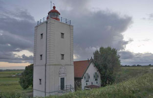
| NL 50 |
| Den Oever
latitude 52° 56' 6.8" N longitude 5° 2' 32.1" E
This lighthouse was originally built at the western end of the island of Wieringen, marking an entrance to the Zuiderzee. In 1930, when the great dike called the Afsluitdijk closed off the mouth of the Zuiderzee and created the IJsselmeer, the lighthouse was relocated to the east end of Wieringen, marking the approach to the lock that admits ocean-going ships to the IJsselmeer.
Photo courtesy Marc de Kleijn [pBase] |
Ijsselmeer West Side
| NL 51 |
De Ven
latitude 52° 44' 31.1" N longitude 5° 16' 56.4" E
Located at Oosterdijk about 6 km north of Enkhuizen.
Photo courtesy Marc de Kleijn [pBase] |
|
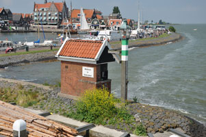
| NL 52 |
| Enkhuizen Range Rear
latitude 52° 41' 57.5" N longitude 5° 17' 34.9" E
This old lightbeacon is well known and often visited. Located at the entrance to the old harbor of Enkhuizen.
Photo courtesy Emil de Jong [Flickr] |
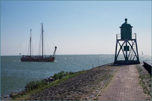
| NL 53 |
Volendam
Volendam is a port on the Markermeer, the southwestern arm of the IJsselmeer, about 32 km northeast of Amsterdam.
Photo courtesy J. Michael Bash [Flickr] |
|
| NL 54 |
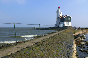
| Marken (Paard van Marken)
latitude 52° 27' 35.1" N longitude 5° 8' 20.4" E
The village Marken is a museum and "carfree", that means paying for parking, entry ... The best way to reach the light is walking along the bicycle path (half an hour) or cycling.
Photo courtesy Nielsvk [Flickr] |
| NL 55 |
Hoek van 't IJ
latitude 52° 22' 18.3" N longitude 5° 50.8" E
Located on a island off the point (the Hoek't IJ) at the northern entrance to the harbor, near Durgerdam. Accessible only by boat.
Photo courtesy Marc de Kleijn [pBase] |
|
Ijsselmeer East Side and Harlingen
| NL 56 |
| Harderwijk (De Vischpoort)
Located on the waterfront in Harderwijk, which was formerly on the south shore of the Zuiderzee and is now on the south shore of the Veluwemeer, the remnant channel between the Zuid Flevoland polder and the mainland of Gelderland. ARLHS # NET-162
Photo courtesy Joke [Flickr] |
| NL 57 |
Elburg (Elborgh)
The historic fortress town of Elborgh formerly stood at the southeastern corner of the Zuiderzee. Since the reclamation of the Oost Flevoland Polder, it has stood beside the Drontermeer, the narrow residual channel between the polder land and the original mainland.
Photo courtesy esdebe [Webshots] |
|
| NL 58 |
| Kraggenburg
The lighthouse now sits in the middle of a field in the Noordoost Polder about 3 km north of the Ketelmeer, the remnant arm of the former Zuiderzee between the Noordoost and Oost Flevoland polders. Private residence. Located about 8 km east of Ens.
Photo courtesy Marc de Kleijn [pBase] |
| NL 59 |
Urk
Lights were lit at Urk as early as 1617. At that time, Urk was an island in the Zuiderzee. Since the reclamation of the Noordoost Polder in the 1930s, Urk has been joined to the mainland, and the lighthouse now stands on the east shore of the IJsselmeer.
Photo courtesy Beta Karel [Flickr] |
|
| NL 60 |
Rotterdamse Hoek |
Located about 12 km north of Urk. There does not appear to be any road access to this location. |
| NL 61 |
Lemmer (replica)
1993 replica of 1887 lighthouse. Located in the town of Lemmer on the east side of the IJsselmeer north of the Noordoost Polder.
Photo courtesy Marc de Kleijn [pBase] |
|
| NL 62 |
| Stavoren High (Range Rear)
latitude 52° 53' 16.4" N longitude 5° 21' 27.3" E
According to the Vuurtorens in Nederland site, the front light (Netherlands 1994) is on a 6 m post. However, several sites claim that the south pierhead light is the front light. Probably there are ranges on both lines. Located just off the Zuiderweg near the waterfront in Stavoren. ARLHS # NET-159
Photo courtesy Marc de Kleijn [pBase] |
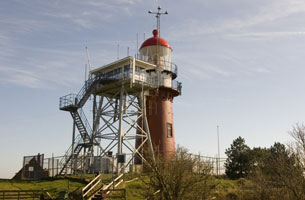
| NL 63 |
Stavoren South Pierhead
latitude 52° 53' 9.2" N longitude 5° 21' 13.8" E
Located on the south breakwater in Stavoren; accessible by walking the breakwater.
Photo courtesy Arjen Stilkik [Flickr] |
|
| NL 64 |
| Stavoren North Pierhead
latitude 52° 53' 10.7" N longitude 5° 21' 8.9" E
The tower has the red painting only since 1919, before it was green. It swapped the colors with the pier light south of course the commencement of international conventions with the reason to harmonize of navigation marks.
Photo courtesy Arjen Stilkik [Flickr] |
| NL 65 |
Workum |
The lighthouse is a private residence. Located by the dike at Hindeloopen, near the northeast corner of the IJsselmeer. |
| NL 66F |
Harlingen Front Range
stands at the head of the south pier. (B 0913.6)
Photo courtesy Alex Trabas [ListOfLights] |
|
| NL 66 |
| Harlingen Rear Range
stands not far away from the old light in the harbour. (B 0913.61)
Photo courtesy Alex Trabas [ListOfLights] |
Wadden Islands
| NL 67 |
Schilbolsnol (1977)
Located 2 km west northwest of 't Horntje. (B 0859)
Photo courtesy Alex Trabas [ListOfLights] |
|
| NL 68 |
| Schulpengat Range Rear (Den Hoorn)
The tower is believed to date from about 1450. Located in Den Hoorn op Texel on the north side of the Zeegat van Texel. The island of Texel is accessible by ferry from Den Helder. ferry (B 0852.1)
Photo courtesy Alex Trabas [ListOfLights] |
| NL 69 |
Eierland (Texel)
latitude 53° 10' 54.9" N longitude 4° 51' 18.7" E
The light station is endangered by beach erosion, which has been controlled by a sea wall. Located at the north end of the island of Texel, marking the Engelschmangat, the inlet between Texel and Vlieland. (B 0886)
Photo courtesy Edwinek [Flickr] |
|
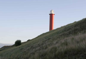
| NL 70 |
| Vuurboetsduin (Vuurduin, Vlieland)
latitude 53° 17' 45.3" N longitude 5° 3' 29.4" E
Located on the highest point of Vlieland, just west of the port town of Oost Vlieland. Vlieland is accessible by passenger ferry from Harlingen on the mainland; in the summer there is also ferry service from the northern end of Texel. ferry (B 0894)
Photo courtesy Marc de Kleijn [pBase] |
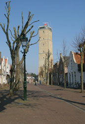
| NL 71 |
Terschelling (Brandaris)
latitude 53° 21' 36.6" N longitude 5° 12' 51.5" E
Oldest lighthouse of the Netherlands.
Located in the village of West Terschelling near the western end of the island of Terschelling (accessible by ferry from Harlingen). ferry (B 0904)
Photo courtesy Marc de Kleijn [pBase] |
|
| NL 72 |
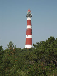
| Ameland (Bornrif)
latitude 53° 26' 57.4" N longitude 5° 37' 32.5" E
Located in Hollum at the western end of the island of Ameland; the island, a popular tourist destination, is accessible by ferry from Holwerd. ferry (B 0920)
Photo courtesy Aldo van Zeeland [Flickr] |
| NL 73 |
Schiermonnikoog
latitude 53° 29' 12.7" N longitude 6° 8' 47.3" E
Located near the west end of the island of Schiermonnikoog, west of the town of the same name. Island accessible by passenger ferry from Lauwersoog on the mainland; special permission is needed to bring cars to the island. ferry (B 0938)
Photo courtesy S. Bar [Flickr] |
|
| NL 74 |
| Schiermonnikoog South
Located in the village of Schiermonnikoog. (Known as the white lighthouse, opposed to the red shown above.) (B 0939.5)
Photo courtesy Heremiet [Flickr] |
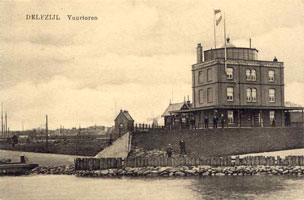
| NL 75 |
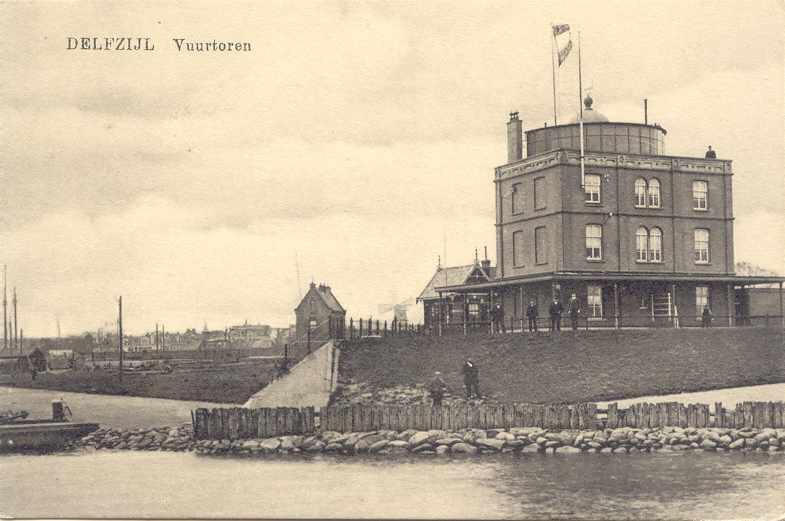
Delfzijl (1891)
This light was located on the waterfront in Delfzijl, the Dutch port on the Eems, about 50 km east of Groningen. It was built in 1889 but destroyed in 1940. ARLHS # NET-004
Photo courtesy Klause Huelse [LeuchtturmWelt] |
|
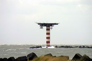
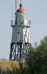
| NL 76 |
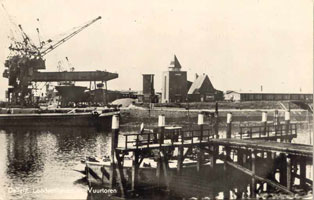
| Delfzijl (1942)
The new light was built in 1942, but removed in 1981 to make room for a larger harbor.
Photo courtesy Klause Huelse [LeuchtturmWelt] |
|
|
 Germany