|
This page shows the documentation of the Northwestern Lighthouses of Norway. You can always click on the photo of the light to go to a specific (larger resolution) copy. Each lighthouse name is linked to (in our editorial opinion) the best reference site for that light. A lighthouse is called a "fyr" in Norwegian. I would like to include directions on how to get to these lights. If you know such data, could you eMail me and I'll post it here (with your choice of attribution.) mailme There has been significant usage of the Lighthouse Directory prepared by Russ Rowlett (UNC). LHdirectory Lighthouse coordinates are via Norsk Fyr. My thanks to them for providing this basis for understanding. NorskFyr |
|
Smøla and Ertvågøy Area
Map is NW
| NO 953 |
Gjeslingskjær |
West of Gjernes. East side of Smøla (L 1156) [403800] |
| NO 954 |
Lyngvær
latitude 63° 16' 37.2" N longitude 7° 45' 56" E |
Southwest of Smøla (L 1318) [425400] |
| NO 955 |
Omsundholmen
latitude 63° 16' 58.2" N longitude 7° 47' 36.6" E |
Southwest of Smøla (L 1319) [425600] |
| NO 956 |
Skardholmen
latitude 63° 20' 43.8" N longitude 7° 46' 31.2" E |
Oddehølen, west of Smøla (L 1342) [429700] |
| NO 957 |
Orholmskjær Vestre
latitude 63° 21' 10.2" N longitude 7° 46' 41.4" E |
west of Smøla (L 1343) [429800] |
| NO 958 |
Orholmskjær Østre (east) |
west of Smøla (L 1343.1) [429900] |
| NO 959 |
Klakkavåg
latitude 63° 21' 24" N longitude 7° 50' 49.8" E |
west of Smøla (L 1344) [430000] |
| NO 960 |
Kalvøy
latitude 63° 21' 27.6" N longitude 7° 51' 33.6" E |
Rusboleia (L 1344.1) [430100] |
| NO 961 |
Litlflisa |
Rusboleia (L 1345) [431500] |
| NO 962 |
Dyrnes
latitude 63° 25' 39" N longitude 7° 50' 25.8" E |
Dyrnes (L 1347) [432500] |
| NO 963 |
Frisholmen
latitude 63° 26' 55.1" N longitude 7° 49' 6.9" E |
Northwest of Dyrnes (L 1351) [433900] |
| NO 963S |
Steinløysa
latitude 63° 27' 4.8" N longitude 7° 51' 40.2" E |
Northwest of Dyrnes (L 1347.6) |
| NO 964 |
Brattværet
latitude 63° 28' 30" N longitude 7° 50' 35.4" E |
North of Dyrnes (L 1350) [433500] |
| NO 965 |
Olaskjær
latitude 63° 27' 37.8" N longitude 7° 50' 15" E |
West Bratvær (L 1349) [433200] |
| NO 966 |
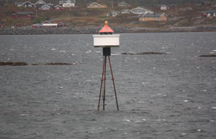
Skalmen
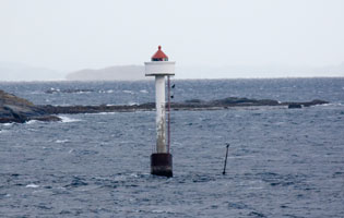
latitude 63° 28' 19.2" N longitude 7° 45' 25.8" E
Located on a skerry about 5 km northwest of Dyrnesvågen, off the northwestern tip of Smøla. (L 1348) [433000]
Photo courtesy marinas.com [Marinas.com] |
|
| NO 967 |
Singsundet |
Near Hvaldragskjær (L 1352) [434000] |
| NO 968 |
Innveien
latitude 63° 30' 36" N longitude 7° 58' 59.4" E |
Located on Sondre Leiskjaer, a skerry about 2 km east of Veiholmen. (L 1364) [435200] |
| NO 969 |
Haugøya
latitude 63° 29' 12.6" N longitude 7° 59' 54" E |
North of Hopen (L 1368) [436100] |
| NO 970 |
Suholmen Vestre (West)
latitude 63° 28' 54" N longitude 8° 1' 19.8" E |
Binningsvaet (L 1370) [436200] |
| NO 971 |
Reiråklakken |
Northeast of Smøla. (L 1376) [441000] |
| NO 972 |
Lyngværpynten |
Northwest of Smøla. (L 1374.8) [439700] |
| NO 973 |
Hestvikholmen |
Near East Smøla. (L 1374.6) [439600] |
| NO 974 |
Pintelen |
Located just off the eastern point of Smøla. (L 1374.4) [439500] |
| NO 975 |
Katholmen Nordre |
Smøla east side (L 1154) [403700] |
| NO 975T |
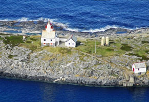
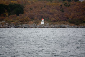
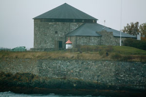
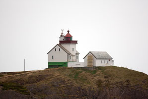
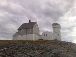
Tyrhaug (Kyrhaug)
latitude 63° 18' 37.2" N longitude 8° 13' 36.6" E
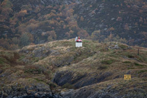
October 14, 2010
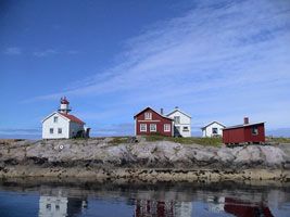
Located on Ringholmen, a small island off the east end of Edøy, which is an island off the southeast coast of Smøla. There should be a good view from Edøy. This picture was taken from the Hurtigruten southbound boat (1 day out of Bergen.) (L 1152) ARLHS # NOR-257 |
|
| NO 976 |
Terningen
latitude 63° 29' 37.8" N longitude 9° 2' 21" E |
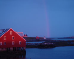
The light guides ships turning southward into the Hemnfjord. Located on a small island about 1 km south of the island of Hitra and 1.2 km southwest of Jøssenøya. The lighthouse is available for overnight accommodations. rooms. (L 1170) [407500] ARLHS # NOR-247 |
| NO 977 |
Ringskjæret
latitude 63° 16' 29.4" N longitude 7° 59' 34.8" E |
Arnøysund, Southwest of Smøla (L 1321) [426000] |
| NO 978 |
Gråskjæret |
Ertvågøy southwest side (L 1150) [403200] |
| NO 979 |
Araneset
latitude 63° 15' 45" N longitude 8° 19' 40.8" E |
Gjerdesvika (L 1108) [388800] |
| NO 980 |
Slyngesten
latitude 63° 16' 13.8" N longitude 8° 22' 33" E |
Gjerdesvika (L 1109) [388900] |
| NO 981 |
Ertvågøya (Stenholmen)
latitude 63° 17' 2.4" N longitude 8° 19' 39.6" E |
Located on a skerry off the northwestern corner of the island of Ertvågøy. (L 1107) [388700] |
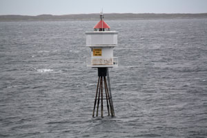
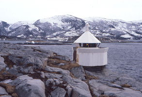
| NO 982 |
Sveholmen
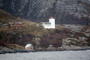
latitude 63° 31' 59.4" N longitude 7° 57' 45" E
Located on a waveswept skerry about 1 km north of Veiholmen on the north side of Smøla. The lighthouse is now open for day tours and available for overnight accommodations rooms (L 1362) [435000]
Photo courtesy Rahul Anantharaman [Flickr] |
|
| NO 983 |
Omfarskjæret
latitude 63° 12' 45.6" N longitude 7° 36' 26.4" E |
South of Grip fyr (L 1122) [389800] |
| NO 984 |
Glomstadhomen
latitude 63° 35' 46.2" N longitude 8° 37' 45" E |
Torsetsund (L 1012) [389200] |
| NO 985 |
Klakksbroren
latitude 63° 21' 12" N longitude 8° 24' 25" E |
Leias east side (L 1164) [405400] |
| NO 986 |
Espeneset
latitude 63° 20' 48" N longitude 8° 42' 5.4" E |
Located on a sharp point of land projecting into the Dromnessund about 12 km northeast of Aure. (L 1114) [389400] |
| NO 987 |
Rognannes
latitude 63° 22' 57" N longitude 8° 38' 50.4" E |
Dromnessund (L 1116) [389500] |
| NO 988 |
Kjørsvikbogen
latitude 63° 24' 51.6" N longitude 8° 43' 19.8" E |
At Kjørsvikbogen (L 1166) [405600] |
Frøya and Hitra Area
| NO 991 |
Værøyene
latitude 63° 24' 40.2" N longitude 8° 27' 18.6" E
October 14, 2010
Southeast Hitra. This picture is taken from a southbound Hurtigruten ferry just hours north of Bergen. (L 1162) [405200] |
|
| NO 992 |
Forsnes
latitude 63° 25' 35.4" N longitude 8° 23' 34.2" E |
Southeast Hitra. Probably visible on the west side of the Forsnes-Edøya ferry. (L 1160) [405000] |
| NO 993 |
Ramsøysund
latitude 63° 25' 48.6" N longitude 8° 20' 10.8" E |
South Hitra (L 1159) [404500] |
| NO 994 |
Kjeøysund |
Hitras southwest side. (L 1377) [441200] |
| NO 995 |
Hernesstraumen |
Hitra southwest side in Dolmsund. (L 1380) [442000] |
| NO 996 |
Sæbuodden |
Hitra southwest side in Ramsøyfjorden. (L 1378) [441400] |
| NO 997 |
Hundholmen
latitude 63° 31' 51.6" N longitude 8° 55' 16.4" E |
Inlet to Helsøysundet. (L 1382) [442300] |
| NO 998 |
Jektvikskjæra
latitude 63° 34' 22.8" N longitude 8° 28' 42" E |
West of Hitra. (L 1382.6) [442800] |
| NO 999 |
Bussøy
latitude 63° 34' 47" N longitude 8° 20' 32" E |
Southwest of Hitra (L 1386) [446000] |
| NO 1000 |
Værsøydraget
latitude 63° 36' 30" N longitude 8° 23' 22.2" E |
North of Burøys, Lomsøya southwest of Hitra (L 1388) [446500] |
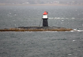
| NO 1001 |
Slettringen
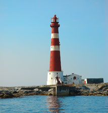
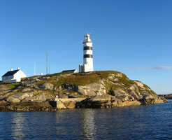
This is Norway's tallest lighthouse. Located on a small island about 1.5 km west of Titran, the village at the western tip of the island of Frøya. (L 1392) [446800] ARLHS # NOR-214
Photo courtesy courtesy Odd Einar Helmersen [wikipedia] |
|
| NO 1002 |
Dolmsund
latitude 63° 38' 45.6" N longitude 8° 52' 32.4" E |
Near Flesa. (L 1385.4) [445000] |
| NO 1003 |
Ilsøyklubben
latitude 63° 39' 34.5" N longitude 8° 53' 41" E |
A stone daybeacon stands near the light. Located on an island off the northeastern tip of Hitra. (L 1385.6) [445500] |
| NO 1004 |
Flesa
latitude 63° 38' 37.8" N longitude 9° 13' 36" E |
This light is an important guide for ships approaching Trondheim from the Norwegian Sea. Flesa is a small island northeast of the eastern tip of Hitra and about 2.5 km due east of the eastern tip of the island of Fjellvaerøy. Accessible only by boat. Don't confuse with the other Flesa below. NO 1127 (L 1192) [410600] |
| NO 1005 |
Børøyholmen (1874)
latitude 63° 34' 6" N longitude 9° 16' 31" E |
The lighthouse appears to be in use as a private residence. Accessible only by boat. |
| NO 1006 |
Børøyholmen (1970) (Rognan)
latitude 63° 34' 6" N longitude 9° 16' 28.8" E |
Rognenes west beach (L 1190) [410000] ARLHS # NOR-065 |
| NO 1007 |
Aunøy
latitude 63° 31' 0.6" N longitude 9° 6' 57" E |
Dybsund east side
The coordinates duplicate (L 1178) [408600] |
| NO 1008 |
Flisa
latitude 63° 25' 1.2" N longitude 9° 8' 16.4" E |
Hemnefjorden (L 1173) [407601] |
| NO 1009 |
Kyrksæterøra Nedre |
Hemnefjorden (the rear range is only a lamp on a post.) [407900] |
| NO 1010 |
Magerøy
latitude 63° 26' 56.8" N longitude 8° 59' 41" E |
Near Ringberget (L 1168) [407000] |
| NO 1011 |
Klakken
latitude 63° 26' 47.4" N longitude 9° 18' 6.6" E |
Astfjord (L 1176) [408200] |
Lower Trondheim and Uthaug Area
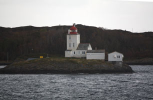
| NO 1013 |
Rognan
latitude 63° 34' 6.3" N longitude 9° 16' 28.9" E |
Located on a dangerous reef off the west end of Sørleksa, in the channel around the eastern tip of Hitra. photo (L 1190) |
| NO 1014 |
Sørleksa |
(As named, it is in) South Leksa on the southeast side (L 1194) [410800] |
| NO 1015 |
Kongsvoll |
Ringholmens north point (L 1196) [411000] |
| NO 1016 |
Tjuvholmen
latitude 63° 38' 33.3" N longitude 9° 28' 33.5" E
October 6, 2010
West of Garten. Don't confuse with NO 416 (L 1200) [411400] |
|
| NO 1017 |
Beian
latitude 63° 39' N longitude 9° 33' 57" E |
West beianhaug (L 1204) [411600] |
| NO 1018 |
Røysaneset
latitude 63° 37' 11.4" N longitude 9° 35' 49.2" E |
Across (south) from Beian (L 1205) [412100] |
Trondheim Area
| NO 1021 |
Hardbaknes
latitude 63° 45' 57.8" N longitude 10° 3' 54.5" E |
Northeast of Agdenes (L 1214) [413400] |
| NO 1022 |
Stikkelsteinan
latitude 63° 43' 25.2" N longitude 9° 59' 34.8" E |
Inlet to Sørfjorden (L 1212) [413000] |
| NO 1023 |
Flesagalten
latitude 63° 42' 10.6" N longitude 9° 51' 50" E |
Skjærets northwest side (L 1208) [412500] |
| NO 1024 |
Ringflua
latitude 63° 38' 51" N longitude 9° 45' 22.6" E
October 14, 2010
This light is located just offshore from the historic Agdenes Fyr and replaced it. Accessible only by boat. It looks like the relocation was done so the light is visible both as you approach and leave the channel (Agdenes is only visible from outside the channel.) (L 1219) [414800] ARLHS # NOR-418 |
|
| NO 1025 |
| Agdenes
latitude 63° 38' 44.6" N longitude 9° 44' 48.9" E
October 14, 2010
This is the oldest light station in the Trondheim area. Replaced in 1984 by the Ringflua Fyr offshore, it has been renovated and is available for overnight accommodations. Located at the west entrance to the Trondheimfjord in Agdenes Kommune. rooms ARLHS # NOR-415 |
| NO 1026 |
Hysnes
latitude 63° 37' 35.6" N longitude 9° 48' 22.1" E
October 6, 2010
Leaving Trondheim, Hysnes is located on the north side of the channel to the open water approximately 15 miles from Trondheim. (L 1222) [414200] |
|
| NO 1027 |
| Røberg (Rødbergsneset)
latitude 63° 28' 44.8" N longitude 9° 59' 56.4" E
October 14, 2010
Just west of Trondheim (and across the sound). It looks like it's on the end of the mole protecting this little harbor. (L 1224) |
| NO 1028 |
Lade Molja
latitude 63° 26' 47.4" N longitude 10° 24' 59.8" E
October 6, 2010
Located at the north end of the Lade (Goods) Mole, on the east side of the entrance to Trondheim's eastern harbor. (L 1238) [416500] ARLHS # NOR-417 |
|
| NO 1029 |
| Skansen
latitude 63° 26' 0.9" N longitude 10° 22' 34" E
October 6, 2010
Located at the west end of a detached breakwater, marking the west entrance to the commercial harbor on the west side of Trondheim. Accessible only by boat, but there are excellent views from shore. (L 1256) [418600] ARLHS # NOR-419 |
| NO 1030 |
Munkholmen
latitude 63° 27' 3.6" N longitude 10° 22' 57" E
October 14, 2010
Munkholmen is an island in the Trondheimfjord about 1.2 km northwest of the Trondheim waterfront. The fort, built in the late 17th century, served for many years as a prison. The light is located on the west side of the fort. fort (L 1232) [415900] ARLHS # NOR-167 |
|
| NO 1031 |
| Østmarktangen (Korsvika)
latitude 63° 27' 24.7" N longitude 10° 26' 42.1" E
This light marks the entrance to the Strindfjord from the Trondheimfjord. Located on a promontory about 3 km northeast of downtown Trondheim. (L 1260) [419300]
Photo courtesy Kim [Flickr] |
| NO 1032 |
Rota |
Hommelvik (L 1262) [419400] |
Trondhemisfjord and Beitstandfjord
| NO 1034 |
Beitstadsund
latitude 64° 1' 44.8" N longitude 11° 13' 38.9" E |
At holmen in Beitstadsundet (L 1310) [423500] |
| NO 1035 |
Eggebogtangen
latitude 64° 38.2" N longitude 11° 27' 51.3" E |
Tangens south point, east of Steinkjær photo (L 1312) [424000] |
| NO 1036 |
Stornesøra
latitude 64° 38.2" N longitude 11° 27' 51.3" E |
North near Inderøya. (L 1308) [423400] |
|
|
| NO 1037 |
Værrasundet |
Inlet to Verrasundet (L 1304) [423000] |
| NO 1038 |
Vennesodden
latitude 63° 52' 47.4" N longitude 11° 2' 58" E |
Skarnsundet (L 1300) [422800] |
| NO 1039 |
Høsholmene
Located at the tip of a rocky peninsula on the east side of the Trondheimsfjord, about 4 km south of Straumen. (L 1294) [422000]
Photo courtesy courtesy R. M. Tronstad [panoramio] |
|
| NO 1040 |
Saltvikhavn
latitude 63° 46' 37.5" N longitude 10° 59' 19.3" E |
Norviksundet (L 1296) [422400] |
| NO 1041 |
Levanger |
In the harbor of Levanger (L 1284) [421200] |
| NO 1042 |
Sandsøra
latitude 63° 44' 39.8" N longitude 11° 2' 13.1" E |
South side of Ytterøya photo (L 1280) [421000] |
| NO 1043 |
Fånes
latitude 63° 38' 11.4" N longitude 10° 46' 47.4" E |
North side of Frosta (L 1276) [420500] |
| NO 1044 |
Stjørdal Havn
latitude 63° 27' 53.7" N longitude 10° 52' 54.6" E |
At the end of the mole in Stjørdal harbor (L 1268) [420000] |
| NO 1045 |
Saltøy
latitude 63° 33' 6.6" N longitude 10° 52' 31.6" E |
Located on a rocky reef projecting into a branch of the Trondheimsfjord about 25 km east of Trondheim. (L 1271) [420200] |
| NO 1046 |
Kornesodden
latitude 63° 35' 2.1" N longitude 10° 49' 18.3" E |
Åsenfjorden (L 1270) [420100] |
| NO 1047 |
Tautra
latitude 63° 35' 0.9" N longitude 10° 36' 40.8" E
Tautra is an island in the entrance to the upper Trondheimsfjord, about 15 km northeast of Trondheim. Site of a 13th century monastery, Tautra is accessible by bridge. Located on a promontory on the north side of the island. (L 1274) [420300]
Photo courtesy marinas.com [Marinas.com] |
|
Åfjord Area
Map is NW2
| NO 1051 |
Strandaunskjæret
latitude 63° 57' 0.6" N longitude 10° 9' 31.7" E |
Northwest in Åfjord (L 1628) [480500] |
| NO 1052 |
Tårnes
latitude 63° 57' 17.5" N longitude 9° 59' 46" E |
Northwest in Skråfjorden (L 1632) [481100] |
| NO 1053 |
Sønstskjær
latitude 63° 58' 32.8" N longitude 9° 57' 56.2" E |
South of Linesøya (L 1636) [481500] |
| NO 1054 |
Bingsholmråsa
latitude 63° 56' 8.8" N longitude 9° 57' 56.2" E |
Near Lyngøybåen (L 1630) [481000] |
| NO 1055 |
Smørholmskjærene
latitude 63° 55' 27.3" N longitude 9° 53' 4.8" E |
North of Lysøysund (L 1616) [479400] |
| NO 1056 |
Åfjord
latitude 63° 53' 55.4" N longitude 9° 57' 46.3" E |
Strømsholmen north point (L 1624) [480000] |
| NO 1057 |
Store Flatholmen
latitude 63° 57' 32.8" N longitude 9° 32' 36" E |
Located on a small island at the western end of the Melstein reef, a cluster of rocks and skerries about 16 km north northwest of Været. (L 1576) [475000] |
| NO 1058 |
Asenvågsøya (Adsenvagøy)
latitude 63° 56' 30.7" N longitude 9° 46' 17.3" E
October 6, 2010
The lighthouse is available for vacation stays in the summer. Located atop a small island in the Norwegian Sea about 6 km northwest of Lysøysund. Accessible only by boat. stays (L 1608) [478600] ARLHS # NOR-190 |
|
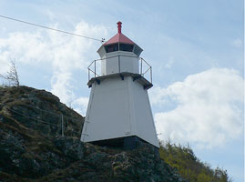
| NO 1059 |
| Oddtaren
latitude 63° 54' 37.8" N longitude 9° 46' 12.6" E
October 6, 2010
North of Asen (L 1604) [478200] |
| NO 1060 |
Treholmen
latitude 63° 54' 33.9" N longitude 9° 46' 23.2" E
October 6, 2010
West of Lysøysund (L 1602) [478100] |
|
| NO 1061 |
Lysøysundet
latitude 63° 53' 27.6" N longitude 9° 52' 26.4" E |
Lysøysund east point (L 1620) [479800] |
| NO 1061S |
Skelhomen
latitude 63° 54' 13.2" N longitude 9° 50' 55.2" E |
Northwest of Lysøysund (L 1614) [479200] |
| NO 1062 |
Skjørøy
latitude 63° 53' 18.5" N longitude 9° 48' 36" E |
Valsøyråsa east side (L 1612) [479000] |
| NO 1063 |
Rødgjæsingen
latitude 63° 53' 11" N longitude 9° 39' 57" E |
Near the west beach of Asenleia (L 1598) [477700] |
| NO 1064 |
Kvaløya
latitude 63° 52' 18.6" N longitude 9° 43' 9" E
October 6, 2010
West of Vallersund (L 1592) [476700] |
|
| NO 1065 |
Valsøyøra |
Valsøy North point (L 1594) [476900] |
| NO 1066 |
Fauskanskjæret
latitude 63° 51' 24" N longitude 9° 46' 4.2" E |
Fauskan (L 1597) [477500] |
| NO 1067 |
Kråktaren
latitude 63° 50' 46.4" N longitude 9° 38' 35.8" E
October 6, 2010
Southwest of Vallersund (L 1588) [476500] |
|
| NO 1068 |
Haldorhamn
latitude 63° 50' 59.8" N longitude 9° 41' 36.6" E |
South from Vallersund (L 1586) [476300] |
| NO 1069 |
Valsfjorden
latitude 63° 48' 49.2" N longitude 9° 39' 17.4" E |
Near Olsvikpynten (L 1580) [475100] |
| NO 1070 |
Valsholmflua
latitude 63° 48' 42" N longitude 9° 35' 16.1" E
October 6, 2010
Located on a shoal about 5 km north of Uthaug. (L 1585) [475800] |
|
| NO 1071 |
Kløvholmen |
Northeast of Husøya (L 1574) [474700] |
| NO 1072 |
Fårøy |
East side of Husøya (L 1572) [474500] |
| NO 1075 |
Bjugnskjæret
latitude 63° 45' 34.6" N longitude 9° 33' 1.7" E
October 6, 2010
Located at the west point of a dangerous reef about 4 km northwest of Uthaug. (L 1566) [473700] |
|
| NO 1076 |
Nervikhammeren |
Bjugnfjorden (L 1564) [473500] |
| NO 1077 |
Tørrskjæret
latitude 63° 45' 41.4" N longitude 9° 27' 27.6" E |
West of Bjugn (L 1568) [473900] ARLHS # NOR-422 |
| NO 1078 |
Kjeungskjær
latitude 63° 43' 36.1" N longitude 9° 31' 49.7" E
October 6, 2010
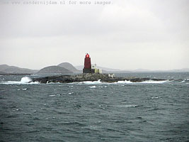
This integral design is very unusual for a Norwegian lighthouse. Located on a very small skerry about 3 km west of Uthaug. Accessible only by boat, but there should be an excellent view from the Breidablikkveien, the coastal road extending westward from Uthaug. (L 1560) [472900] ARLHS # NOR-137 |
|
| NO 1079 |
| Ribeflue
latitude 63° 42' 10.2" N longitude 9° 30' 55" E
October 6, 2010
West of Ørlandet (L 1558) [472700] |
| NO 1080 |
Kvisten
latitude 63° 42' 18.6" N longitude 8° 26' 32.4" E |
Frøya southwest side (L 1452) [458000] |
| NO 1081 |
Sandholmen
latitude 63° 42' 0.2" N longitude 9° 26' 57.4" E |
Located on a skerry about 5 km west of the Kjeungskjær lighthouse.
Be careful with simple name look-ups of Sandholmen. There are many of them in Norway. (L 1561) [473000] |
| NO 1082 |
Kvitingen |
West of Halten fyr (L 1554) [472200] |
| NO 1083 |
Halten
latitude 64° 10' 22.2" N longitude 9° 24' 21.6" E
This is one of the twin lighthouses built at Lista, near Vestbygda in Vest-Agder county. It was dismantled in 1874 and rebuilt here the following year. Located on an isolated island in the Norwegian Sea about 40 km northeast of Mausund. Accessible only by boat in heavy seas. (L 1550) [471800] ARLHS # NOR 106
Photo courtesy courtesy Per Sistens [Flickr] |
|
| NO 1084 |
Keilskjæret |
Southwest of Halten fyr (L 1544) [471400] |
| NO 1085 |
Gimsan |
South of Halten fyr (L 1548) [471600] |
| NO 1086 |
Kristianskjæra |
In the middle of Finnvær (L 1546) [471200] |
| NO 1087 |
Finnværet (1912) |
Located on a small island in the Norwegian Sea about 27 km northeast of Mausund. Accessible only by boat. [471000] ARLHS # NOR-080 |
| NO 1089 |
Nordbuan
latitude 64° 2' 46" N longitude 9° 11' 35" E |
Southeast of Finnvær (L 1539) [470100] |
| NO 1090 |
Kunna Nordøst Pynt (NE point) |
Southeast of Finnvær (L 1538) [470000] |
| NO 1091 |
Bleika |
South of Finnværet (L 1542) [470500] |
| NO 1092 |
Sauøy Vestre (west)
latitude 63° 59' 36" N longitude 9° 9' 42" E |
Skagets east Side (L 1536) [469500] |
| NO 1093 |
Sauøya Austre (east) |
Located on the east point of the island of Østre (East) Sauøy, about 25 km east northeast of Mausand. Accessible only by boat. (L 1534) [469400] |
| NO 1094 |
Flyndreskjæret
latitude 63° 58' 14" N longitude 9° 5' 17" E |
Sørburøy (L 1532) [469300] |
| NO 1095 |
Torvholmen
latitude 63° 57' 47" N longitude 9° 1' 12" E |
Hestvær (L 1530) [469000] |
| NO 1096 |
Gjæsingbogen
latitude 63° 55' 46.2" N longitude 8° 57' 18" E |
East of Purkholmen (L 1529) [468800] |
| NO 1097 |
Gjesingen (Gjæsingen)
latitude 63° 55' 40.2" N longitude 8° 54' 28.2" E |
Gjesingen is a populated island about 12 km east northeast of Mausand. Located at the southern tip of the island. Accessible only by boat. (L 1528) [468500] |
| NO 1098 |
Vingleia (1921)
latitude 63° 54' 58" N longitude 8° 40' 28" E
The lighthouse has been renovated and is available for overnight and vacation accommodations. Located on a small island in the Norwegian Sea about 4 km north of Mausund. Accessible only by boat. [467300] ARLHS # NOR-278 |
|
| NO 1099 |
Vingleia (1985)
latitude 63° 54' 57.5" N longitude 8° 40' 27" E |
Located adjacent to the historic lighthouse. (L 1520) [467300] ARLHS # NOR-423 |
| NO 1100 |
Skotskjær Østre (east)
latitude 63° 53' 39" N longitude 8° 45' 43.8" E |
Northeast of Mausundvær (L 1526) [468000] |
| NO 1101 |
Landbøtskjær
latitude 63° 52' 36.5" N longitude 8° 38' 51" E |
Mausundvær (L 1522) [467700] |
| NO 1102 |
Mauøy
latitude 63° 51' 31.2" N longitude 8° 39' 18" E |
Mauøya (L 1496) [463200] |
| NO 1103 |
Skogsøy
latitude 63° 50' 31.2" N longitude 8° 38' 24.2" E |
South of Mausundvær (L 1494) [463000] |
| NO 1104 |
Remmingsskjær |
Located on a skerry in open water about 5 km east of the eastern point of Smøla. Accessible only by boat. (L 1374) [439000] |
| NO 1105 |
Leiholmtaren
latitude 63° 51' 33" N longitude 8° 30' 23.4" E |
Northeast of Sula (L 1514) [465800] |
| NO 1106 |
Maltsækken
latitude 63° 51' 11.4" N longitude 8° 54' 43.6" E |
Gulskitleia (L 1510) [465600] |
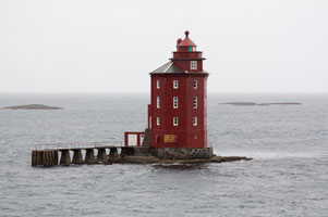
| NO 1107 |
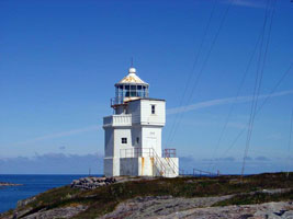
Sula
latitude 63° 50' 51" N longitude 8° 27' 10.8" E
This station is an important landfall light for the Trondheim area. The first lighthouse was replaced in 1804. Located on a small island in the Norwegian Sea about 8 km north of Frøya. (L 1504) [465000] ARLHS # NOR 043
Photo courtesy courtesy dristori [webshots] |
|
| NO 1108 |
Håskjær |
Southeast of Sula (L 1503) [464800] |
| NO 1109 |
Kya
latitude 63° 46' 24" N longitude 8° 18' 44" E
Confusingly, this light has the same name as another lighthouse described below. Located on a small island about 4 km north of the western tip of Frøya. NO 1179 (L 1472) [460200] ARLHS # NOR-147
Photo courtesy Roger Husvik [panoramio] |
|
| NO 1110 |
Lille Leiskjær
latitude 63° 46' 15" N longitude 8° 19' 8.4" E |
Kyahølen (L 1470) [460000] |
| NO 1111 |
Sydkya |
Kyahølen. Holmens southeast side. (L 1468) [459800] |
| NO 1112 |
Humlingsvær |
West of Frøya (L 1466) [459500] |
| NO 1113 |
Edøya
latitude 63° 39' 30" N longitude 8° 40' 34.2" E |
North of Dolmøya (L 1409) [448900] |
| NO 1114 |
Frøyfjorden
latitude 63° 39' 19.2" N longitude 8° 29' 26.4" E |
Near Flesa, south of Frøya. Well out in the fjord, you'll need a boat to see this one. (L 1407) [448500] |
| NO 1115 |
Håvika
latitude 63° 39' 49.8" N longitude 8° 21' 33" E |
East of Titran (L 1402) [447700] |
| NO 1116 |
Titran
latitude 63° 39' 45.2" N longitude 8° 17' 45.2" E |
Located on a skerry just off Titran, at the western tip of the island of Frøya. Accessible only by boat. (L 1394) [446900] |
| NO 1117 |
Sildholmen
latitude 63° 39' 52.2" N longitude 8° 17' 22.2" E |
(Literally "sild=herring, holmen=little island." Titran's west harbor (L 1398) [447500] |
| NO 1118 |
Gulholmen
latitude 63° 43' 13.8" N longitude 8° 33' 18.6" E |
Frøya southwest side (L 1454) [458100] |
|
|
| NO 1119 |
Hågsteinøya
latitude 63° 43' 51.6" N longitude 8° 35' 36.6" E |
Indrehølen (L 1458) [458400] |
| NO 1120 |
Urdsvikholmen
latitude 63° 44' 49.8" N longitude 8° 38' 49.8" E |
West side of Frøya (L 1462) [458800] |
Bjugn, Troan and Osen Area
| NO 1121 |
Håholmen
latitude 63° 46' 30.6" N longitude 8° 36' 57.5" E |
West side of Frøya (L 1480) [460800] |
| NO 1122 |
Lyngøyholmen
latitude 63° 48' 57.6" N longitude 8° 43' 31.8" E |
Northwest side of Frøya (L 1490) [461800] |
| NO 1123 |
Dolsøy
latitude 63° 48' 29.4" N longitude 8° 49' 11.4" E |
East of Dolsøy (L 1500) [463800] |
| NO 1124 |
Nordran
latitude 63° 48' 2.5" N longitude 8° 52' 27" E |
North of Uttian (L 1423.2) [452600] |
| NO 1125 |
Kamholmen
latitude 63° 45' 39" N longitude 8° 52' 39" E |
South of Uttian (L 1422.08) [452400] |
| NO 1126 |
Meholmen
latitude 63° 42' 42" N longitude 8° 52' 45" E |
West Indtian (L 1422) [451600] |
| NO 1127 |
Flesa
latitude 63° 40' 36.5" N longitude 8° 48' 55.2" E |
Between Frøya and North Dolmøy Don't confuse with the Flesa above. NO 1004 (L 1419) [451000] |
| NO 1128 |
Krabsundet
latitude 63° 38' 56.4" N longitude 9° 10.8" E |
Hitra northeast side (L 1426) [455900] |
| NO 1129 |
Filholmen
latitude 63° 36' 24" N longitude 8° 59' 21" E |
In Fillfjorden (L 1424) [455500] |
| NO 1130 |
Knarrlagsund Auster
latitude 63° 39' 28" N longitude 9° 8' 56" E |
Fjellværøya northeast side (L 1432) [457000] |
| NO 1131 |
Grønnholmen
latitude 63° 40' 45.6" N longitude 9° 9' 9.6" E |
West Herøy (L 1434) [457500] |
| NO 1132 |
Knarlagsund Vestre (west)
latitude 63° 39' 54.6" N longitude 9° 1' 11.4" E |
At Inlet to Mysingen (L 1430) [456600] |
| NO 1133 |
Husneset
latitude 63° 39' 28.2" N longitude 8° 46' 44.4" E |
North at Dolmøya (L 1411) [449100] |
| NO 1134 |
Torsøya
latitude 63° 36' 47.4" N longitude 8° 28' 49.2" E |
St. Torsøya east point (L 1408) [448700] |
Vikna and Leka Area
Map is NW3
| NO 1135 |
Sørøyan |
Surenøy south point (L 1866) [533000] |
| NO 1136 |
Kvitingen
latitude 64° 45' 15.7" N longitude 10° 46' 13.5" E |
Located on a small island about 1.6 km west of Heimvær. (L 1858) [532000] |
| NO 1137 |
Blikkøya Nord (north)
latitude 64° 45' 44.6" N longitude 10° 51' 2.6" E |
North of Gjeslingan (L 1862) [532500] |
| NO 1138 |
Heimværet (Heimvær)
latitude 64° 44' 23.1" N longitude 10° 46' 35" E |
Located at the harbor entrance of Heimvær, on a small island about 16 km southwest of Rørvik. (L 1854) [531500] |
| NO 1139 |
Tronflesa
latitude 64° 43' 38.9" N longitude 10° 43' 53.3" E |
West of Gjeslingan (L 1856) [531700] |
| NO 1140 |
Gjæslingan Søre (south)
latitude 64° 44' 1" N longitude 10° 49' 29.2" E |
Northwest of Gjeslingan Flickr (L 1852) [531000] |
| NO 1141 |
Gjeslingan (Gjæslingan)
latitude 64° 43' 38.1" N longitude 10° 51' 14.6" E
Located on a small skerry in the wide mouth of the Follafjord about 15 km north of Lauvsnes. Accessible only by boat. (L 1846) [530000] ARLHS # NOR-018
Photo courtesy Heine (Ken) [Flickr] |
|
| NO 1142 |
| Grinna
latitude 64° 45' 15.5" N longitude 10° 58' 29" E
Located on a small skerry about 6 km north northeast of the Gjeslingan lighthouse in the mouth of the Follafjord. Accessible only by boat. (L 1842) [529500] ARLHS # NOR-099
Photo courtesy Sander Nijdam [panoramio] |
| NO 1143 |
Ormtunga
latitude 64° 45' 12" N longitude 11° 10' 27" E |
North of Abelvær (L 1826) [525000] |
| NO 1144 |
Sandvikodden
latitude 64° 49' 31.2" N longitude 11° 13' 24" E |
East Nærøya (1834) [528000] |
| NO 1145 |
Oterholmsund
latitude 64° 44' 33.6" N longitude 11° 6' 37.8" E |
West of Abelvær (L 1824) [524100] |
| NO 1146 |
Abelvær
latitude 64° 43' 25.2" N longitude 11° 9' 52.8" E |
South of Abelvær (L 1822) [524000] |
| NO 1147 |
Tolandssundet
latitude 64° 46' 52.2" N longitude 11° 26' 47.4" E |
Foldenfjorden west side (L 1789) [516000] |
| NO 1148 |
Kjeøya
latitude 64° 48' 21.7" N longitude 11° 34' 58.1" E |
Foldenfjorden west side Flickr (L 1790) [516500] |
| NO 1149 |
Galtnesskjæret
latitude 64° 47' 27.6" N longitude 11° 44' 6.8" E |
Opløyfjorden (L 1791) [517000] |
| NO 1150 |
Kvalholmen
latitude 64° 45' 0.8" N longitude 11° 31' 22.1" E |
Smineset (L 1788) [515400] |
| NO 1151 |
Rypneset
latitude 64° 42' 42" N longitude 11° 24' 23" E |
North Gyltfjorden (L 1784) [515000] |
| NO 1152 |
Flotra (Flottra)
latitude 64° 40' 14.4" N longitude 11° 3' 26.1" E |
Located on a small island about 6.5 km northeast of Utvorda. Petter Hamnes has a distant photo. photo (L 1764) [510500] |
| NO 1153 |
Jevika
latitude 64° 37' 52" N longitude 11° 8' 41.5" E |
Northeast Otterøya (L 1782) [514000] |
| NO 1154 |
Løvøya
latitude 64° 33' 49.5" N longitude 11° 19' 27" E |
Lauvøyfjorden (L 1780) [513500] |
| NO 1155 |
Levra
latitude 64° 31' 33.6" N longitude 11° 28' 11.2" E |
Lokkaren (L 1778) [513000] |
| NO 1156 |
Knappholman
latitude 64° 36' 28.3" N longitude 11° 1' 26.1" E |
Ytre Namsen (L 1766) [511000] |
| NO 1157 |
Sørnamsen
latitude 64° 34' 7.1" N longitude 11° 5' 17.3" E |
Namsen (L 1768) [511500] |
| NO 1158 |
Bromesneset
latitude 64° 28' 51" N longitude 11° 18' 39" E |
Namsen (L 1772) [512000] |
| NO 1159 |
Lokkaren
latitude 64° 29' 7.2" N longitude 11° 25' 23.4" E |
Lokkarsundet (L 1776) [512500] |
| NO 1160 |
Digerneset
latitude 64° 26' 54" N longitude 11° 29' 52.5" E |
Tvers Namsos (L 1775) [512400] |
| NO 1161 |
Bangsund
latitude 64° 25' 0.2" N longitude 11° 20' 48.9" E |
Brandøy north point (L 1774) [512200] |
Flatanger Area
| NO 1163 |
Vordsundet
latitude 64° 36' 19.2" N longitude 10° 57' 14.9" E |
Near the lighthouse is an old stone beacon, painted white on one side and black with a white horizontal band on the other. This might be the 1898 light, but more likely it is an even older daybeacon. Located on a small island just off a promontory near Utvorda. Petter Hamnes has a photo. photo (L 1758) [509900] |
| NO 1164 |
Skjevillen
latitude 64° 35' 17.8" N longitude 10° 54' 5.2" E |
Flatanger off the north coast of Asholmen. (L 1756) [509700] |
| NO 1165 |
Rekkøyråsa
latitude 64° 36' 30" N longitude 10° 51' 36.6" E |
Flatanger (L 1754) [509500] |
| NO 1166 |
Jensøyholmen
latitude 64° 34' 58.5" N longitude 10° 49' 45.6" E |
Ellingråsa (L 1752) [509300] |
| NO 1167 |
Ellingråsa
latitude 64° 34' 27.9" N longitude 10° 48' 3.9" E |
Located on the north coast of Byørøy, marking the passage between that island and Ellingen, about 5 km northwest of Lauvsnes.
The new light is a square skeletal tower in front of the old house. (L 1750) [509100] ARLHS # NOR-071 |
| NO 1168 |
Feøya
latitude 64° 33' 19" N longitude 10° 53' 15.8" E |
Flatanger on the northwest point of Feøy. (L 1749) [509000] |
| NO 1169 |
Kvernøyråsa
latitude 64° 32' 9" N longitude 10° 48' 32.4" E |
Flatanger. Kvernøy east side (L 1748) [508500] |
| NO 1170 |
Villa
latitude 64° 32' 42.6" N longitude 10° 40' 53.8" E
This lighthouse was designed to burn coal, and did so until it was converted to oil in 1859. Located on an island off Flatanger. Accessible only by boat. ARLHS # NOR-276
Photo courtesy Lars Forseth [Flickr] |
|
| NO 1171 |
Einfika
latitude 64° 30' 36.6" N longitude 10° 49' 19.2" E |
Flatangerleia. Near Hestholmens north point. (L 1747) [508000] |
| NO 1172 |
Krokholmen
latitude 64° 29' 20.3" N longitude 10° 39' 50.5" E |
Flatangerleia (L 1737) [506200] |
| NO 1173 |
Selsvikodden
latitude 64° 27' 42" N longitude 10° 41' 24" E |
Flatangerleia (L 1734) [505500] |
| NO 1174 |
Trollsteinodden
latitude 64° 28' 3.6" N longitude 10° 39' 35.6" E |
Flatanger (L 1732) [505000] |
| NO 1176 |
Hasvågøya |
Flatanger (L 1728) [504000] |
| NO 1177 |
Leiskjæret |
Auksundsleia (L 1726) [501500] |
Nord-Trøndelag County
Map is NW3
| NO 1179 |
Kya |
Confusingly, this light has the same name as another lighthouse described above. This is one of the most exposed lighthouses of the Norwegian coast, and despite its sturdy stone base it has suffered repeated storm damage over the years. Located on a tiny islet in the Norwegian Sea about 16 km northwest of Sandviksberget. NO 1109
Accessible only by boat. photo (L 1722) [500000] ARLHS # NOR-147 |
| NO 1180 |
Saksa
latitude 64° 24' 8.5" N longitude 10° 25' 55.8" E
October 6, 2010
West of Sætervik. (L 1718) [489600] |
|
| NO 1181 |
| Buholmråsa
latitude 64° 24' 6.4" N longitude 10° 27' 11.9" E
October 6, 2010
The houses are available for overnight accommodations. Air raids during World War II damaged several of the buildings at this station, which marks the entrance to the Svefjord. Located on a small island off the end of a peninsula about 4 km north of Sandviksberget. Accessible only by boat. (L 1720) [489700] ARLHS # NOR-063 |
| NO 1182 |
Bjørsneset
latitude 64° 21' 6" N longitude 10° 26' 36" E
October 6, 2010
North of Vingsand (L 1706) [488300] |
|
| NO 1183 |
Raudøya Søre (front range)
latitude 64° 22' 9.5" N longitude 10° 24' 21.1" E |
Southwest of Buholmrasa. The rear range is a lantern mounted on a pole. (L 1716) [489100] |
| NO 1184 |
Sætervågen
latitude 64° 23' 43.1" N longitude 10° 28' 41.4" E |
At the end of the south Mole photo (L 1708) [488500] |
| NO 1185 |
Ramsøysundet
latitude 64° 19' 49.2" N longitude 10° 26' 55.2" E
October 6, 2010
Just north of the coast of Sandviksberget. It's at the entrance to a very narrow section of the channel. (L 1704) [487900] |
|
| NO 1186 |
Kvalhausen |
Northwest of Hepsøya (L 1698) [487700] |
| NO 1187 |
Hepsøya |
Bessaker - Folla on the west side of the island. (L 1696) [487500] |
| NO 1188 |
Bessaker |
Bessakerholmens west side (L 1690) [486500] |
| NO 1189 |
Terningen
latitude 64° 13' 23.3" N longitude 10° 14' 13.3" E
On the West most point in north Terningen island. The lighthouse is available for overnight accommodations. accomodations (L 1686) [486200]
Photo courtesy Morten Skogly [Flickr] |
|
| NO 1190 |
Kaura
latitude 64° 13' 48.3" N longitude 10° 8' 0.1" E |
This design is the closest thing in Norway to the "sparkplug" cast iron lighthouses of the U.S. Sibling of Kya Fyr. Located on a small skerry in the Norwegian Sea about 6 km northwest of Roan. Accessible only by boat. photo (L 1682) [485800] ARLHS # NOR-135 |
| NO 1191 |
Almenningsværet |
West Værøya (L 1678) [485600] |
| NO 1191F |
Farmannsøya |
Northwest of Brandsøya (L 1676) [485400] |
| NO 1192 |
Roan
On the point which is on the north side of the inlet to the Roan harbor. (L 1684) [486000]
Photo courtesy courtesy Kai Krog Halse [Flickr] |
|
| NO 1193 |
| Marflesa
latitude 64° 9' 50.9" N longitude 10° 7' 27.9" E
October 6, 2010
Southwest of Brandsøya (L 1674) [485200] |
| NO 1194 |
Skjørafjord
latitude 64° 5' 18" N longitude 10° 11' 14" E |
Near Håvikneset (L 1672) [485000] |
| NO 1195 |
Pålodden |
North of Stokksundet (L 1666) [484600] |
| NO 1196 |
Hosnaøyan
latitude 64° 6' 25" N longitude 9° 53' 45.3" E |
West of Stokksund (L 1670) [484800] |
| NO 1197 |
Skjaervikpynten
latitude 64° 3' 28.4" N longitude 10° 2' 33" E |
Located at the narrowest point of the Stokksund about 600 m northwest of the Stokkneset light. Accessible only by boat. (L 1664) [484400] ARLHS # NOR-420 |
| NO 1198 |
Høyholmen |
opposite the Stokkneset Light (see above) NO 327 (L 1659) [484000] |
| NO 1199 |
Stokkneset
latitude 64° 3' 3.9" N longitude 10° 3' 7.5" E |
Located on a small island off the eastern tip of the island of Stokkøya. Accessible only by boat. (L 1660) [484200] |
| NO 1200 |
Krokholmen
latitude 64° 2' 37" N longitude 10° 1' 16" E |
South of Stokksund (L 1656) [483600] ARLHS # NOR-421 |
| NO 1201 |
Stegleholmen
latitude 64° 2' 22.2" N longitude 10° 1' 24" E |
South of Stokksund (L 1654) [483400] |
| NO 1202 |
Lina
latitude 64° 2' 55.8" N longitude 9° 55' 22.8" E |
Northeast of Linesøya (L 1648) [483000] |
| NO 1203 |
Storskjær |
Northwest of Linesøya (L 1640) [482000] |
| NO 1204 |
Bruskjærbåen
latitude 64° 16.8" N longitude 9° 56' 56.7" E |
East of Linesøya (L 1642) [482400] |
| NO 1205 |
Slåttøy
latitude 63° 59' 34.3" N longitude 9° 51' 49.4" E |
South of Linesøya (L 1637) [481600] |
Rørvik Area
Map is NW4
| NO 1209 |
Sklinna
latitude 65° 12' 7.1" N longitude 10° 59' 43.5" E |
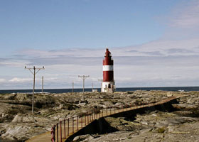
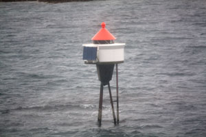
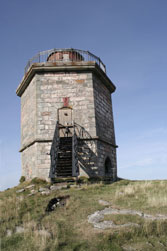
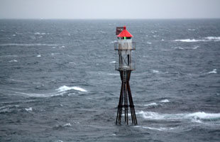
The original 2° Fresnel lens remains in use. Located at the highest point of the isolated island of Heimøya, about 15 km north of Vikna. Accessible only by boat. photo (L 1936) [560000] ARLHS # NOR-207 |
| NO 1210 |
Hårholmsflu |
Sklinna harbor (L 1938) [560100] |
| NO 1211 |
Bårdskjeret
latitude 65° 12' 34.4" N longitude 10° 58' 56.3" E |
Sklinna harbor (L 1940) [560200] |
| NO 1212 |
Jakobsflesa
latitude 65° 7' 35.8" N longitude 10° 58' 43.5" E |
Near skjærene north from Djupråsa (L 1934) [558000] |
| NO 1213 |
Emåriskjeret
latitude 65° 11' 56.2" N longitude 11° 28' 59.9" E |
West, in Hortensfjorden (L 1986) [567100] |
| NO 1214 |
Abrahamskjeret
latitude 65° 11' 31.4" N longitude 11° 27' 9.8" E |
West, in Hortensfjorden (L 1984) [567000] |
| NO 1215 |
Steinsflesa
latitude 65° 8' 37.3" N longitude 11° 31' 3.2" E |
In the middle of Hortensfjorden (L 1982) [566400] |
| NO 1216 |
Kjeldværøy |
North Leka (L 1976) [566200] |
| NO 1217 |
Leknesvika (Bryggeneset)
latitude 65° 6' 45.4" N longitude 11° 43' 11.9" E |
Located on a rock off the northwest coast of the island of Leka. (L 1974) [566000] |
| NO 1218 |
Gutvik Søre (south) |
Near Sæla. (L 1970) [565600] |
| NO 1219 |
Knerten
latitude 65° 4' 20.2" N longitude 11° 41' 35.7" E |
Southeast Leka Flickr (L 1968) [565400] |
| NO 1220 |
Frøviksundet |
Southeast Leka (L 1962) [565000] |
| NO 1221 |
Madsøygalten
latitude 65° 2' 29.1" N longitude 11° 40' 53.3" E |
Southeast from Madsøya (L 1960) [564500] |
| NO 1222 |
Sjøliodden
latitude 65° 12" N longitude 11° 44' 30" E |
Årsetfjorden (L 1958) [564000] |
| NO 1223 |
Store Kvitholmen
latitude 65° 59" N longitude 11° 35' 60" E |
West of Dolma (L 1954) [563500] |
| NO 1224 |
Dolmsundet |
Dolmsundet (L 1951) [562400] |
| NO 1225 |
Ivarholmen
latitude 64° 58' 43" N longitude 11° 33' 24" E |
Northeast from Gjerdingen (L 1948) [562200] |
| NO 1226 |
Rypån
latitude 64° 58' 56.2" N longitude 11° 35' 40.9" E |
South from Dolma (L 1949) [562300] |
| NO 1227 |
Gjerdinga Nedre (Front Range) |
Lamholmen's south point (L 1920) [553700] |
| NO 1228 |
Gjerdinga Øvre (Rear Range)
latitude 64° 56' 52.3" N longitude 11° 24' 14.4" E |
Gjerdingens west beach (L 1920.1) [553600] |
| NO 1229 |
Stongholmgalten |
Southeast from Gjerdingen (L 1940) [561100] |
| NO 1230 |
Svinstien
latitude 64° 55' 3" N longitude 11° 23' 49.7" E |
North from Rørvik (L 1916) [553100] |
| NO 1231 |
Hummulråsa
latitude 64° 54' 45.3" N longitude 11° 22' 3.3" E |
On Svinøy's southwest point (L 1918) [553500] |
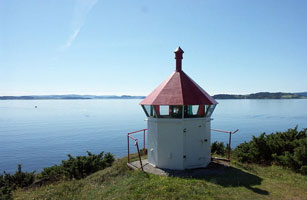
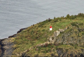
| NO 1232 |
Strømøyhodet
latitude 64° 52' 3" N longitude 11° 15' 35.4" E |
West Rørvik (L 1911) [552600] |
| NO 1233 |
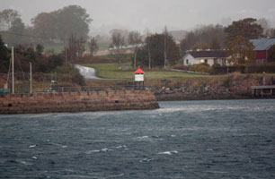
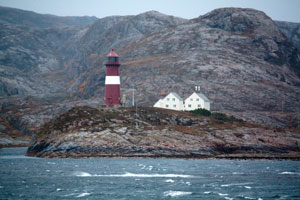
Rørvik
latitude 64° 51' 37.6" N longitude 11° 16' 11.3" E |
Ships on Norway's inside passage make a tight turn around this light, so it is often photographed. Located on Lille Lyngøy, a small island about 1.6 km east of the Rørvik waterfront. photo (L 1909) [552000] |
| NO 1234 |
Ravmnholmen
latitude 64° 56' 9" N longitude 11° 14' 14.6" E |
East side Indre-Vikna (L 1924) [554200] |
| NO 1235 |
Mantalbyen
latitude 64° 58' 30.5" N longitude 11° 9' 45.2" E |
Northeast of Ytre Vikna. (L 1895) [542000] |
| NO 1236 |
Ternholmen |
Måholmråsa (L 1929) [555000] |
| NO 1237 |
Fruflesa |
Northeast Valøya (L 1933) [557000] |
| NO 1238 |
Måholmen Nedre (Front Range)
latitude 65° 31.9" N longitude 10° 56' 54.1" E |
Måholmråsa (L 1930) [555400] |
| NO 1239 |
Måholmen Øvre (Rear Range) |
Måholmråsa (L 1930.1) [555300] |
| NO 1239L |
Litlbremøy |
Måholmråsa (L 1932) [556000] |
| NO 1240 |
Mefjordsholmen |
West of Ytre Vikna. [546000] |
| NO 1241 |
Masterskjæret
latitude 64° 56' 24" N longitude 10° 49' 14.4" E |
West side of Ytre Vikna. (L 1895.4) [544500] |
| NO 1242 |
Sædlingsholmen |
North of Nordøyan. (L 1882.35) |
| NO 1243 |
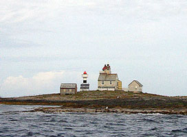
Veirskaftet
latitude 64° 48' 37.4" N longitude 10° 32' 35.6" E |
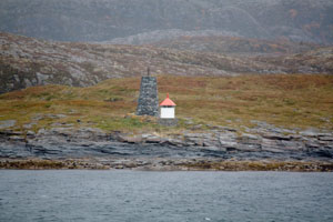
Nordøyan photo (L 1882) [535100] |
| NO 1244 |
Purkholmen
latitude 64° 48' 12" N longitude 10° 33' 7.4" E |
Nordøyan. Note the second light identified as Purkholmen below. NO 337J (L 1874) + [534500] |
| NO 1245 |
Gullfrøholmnakken |
West of Nordøyan. (L 1880) [534900] |
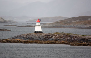
| NO 1246 |
Nordøyan
latitude 64° 47' 54.3" N longitude 10° 32' 51.9" E
The original 1° Fresnel lens remains in use. Located on a small island at the southwestern end of the Nordøyan (North Islands) about 10 km southwest of the principal island of Vikna. photo (L 1868) [533500] ARLHS # NOR-033
Photo courtesy Owen Morgan [panoramio] |
|
| NO 1247 |
Surnøya
latitude 64° 47' 50.4" N longitude 10° 32' 39.6" E |
South of Nordøyan (above). (L 1870) [534000] |
| NO 1248 |
Råholmen |
East of Nordøyan. (L 1833) [535300] |
| NO 1249 |
Håskjær |
Håskjær (L 1876) [534700] |
| NO 1250 |
Bendøyskjæret
latitude 64° 48' 42" N longitude 10° 38' 57.5" E |
Located on a skerry in the Nordøyan (North Islands) about 5.5 km northeast of the Nordøyan lighthouse. (L 1884) [535500] |
| NO 1251 |
Skarvskjæret
latitude 64° 47' 52.6" N longitude 10° 46' 1" E |
East of Nordøyan. (L 1888) [537500] |
| NO 1252 |
Purkholmen |
Nordøyan. Note the second light above identified as Purkholmen. NO 1244 (L 1887) [537000] |
| NO 1253 |
Karstenøysund
latitude 64° 50' 57.7" N longitude 10° 47' 7.2" E |
Northeast of Nordøyan (L 1890) [538500] |
| NO 1254 |
Hysskjæret Søre (south)
latitude 64° 49' 39.9" N longitude 10° 48' 51.5" E |
East of Nordøyan. (L 1889) [538000] |
| NO 1255 |
Sleipskjæret |
Southeast Mellomvikna. (L 1893) [540000] |
| NO 1256 |
Svinøya
latitude 64° 50' 47.4" N longitude 10° 49' 38.4" E |
Langsundets southeast side. (L 1892) [539500] |
| NO 1257 |
Langholmen |
Southwest Mellom-Vikna. (L 1894) [541000] |
| NO 1258 |
Husvedøya |
North of Grinna. (L 1898) [550000] |
| NO 1259 |
Stamnesskjærflua
latitude 64° 48' 57.6" N longitude 11° 4' 5.9" E |
Indre Viknas south end. (L 1899) [550100] |
| NO 1260 |
Risværet |
Northeast from Gjerdingen (L 1946) [562000] |
| NO 1261 |
Prestøygalten
latitude 64° 47' 19.1" N longitude 11° 5' 51.4" E |
Southwest of Rørvik. (L 1900) [551000] |
| NO 1262 |
Naerøysund (1841) |
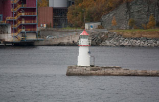
The lighthouse was originally built at Prestøy and was relocated to Naerøysund in 1904. Located on the north side of the Naerøysund, which separates the island of Vikna from the mainland, out 2 km southwest of Rørvik. photo [551500] ARLHS # NOR-175 |
| NO 1263 |
Nærøysund (1984)
latitude 64° 50' 34.2" N longitude 11° 11' 41.2" E |
Located at the shoreline near the historic lighthouse. photo (L 1904) [551500] |
| NO 1264 |
Pundsøya
latitude 64° 46' 50.4" N longitude 11° 17' 7.2" E |
South of Arnøya (L 1828) [525500] |
| NO 1265 |
Bertillen |
Arnøyfjorden (L 1828.2) [525600] |
| NO 1266 |
Arnøysteinskjæret |
Rossøystrømmen (L 1832) [526500] |
| NO 1267 |
Skaftenes
latitude 64° 56' 48" N longitude 12° 34.8" E |
Indre Folla (L 1803) [519400] |
| NO 1268 |
Bergsodden
latitude 64° 56' 39.6" N longitude 12° 11' 40.2" E |
East of Foldereid (L 1811) [520100] |
| NO 1269 |
Skjølstad Østre (east) |
Indre Folla (L 1805) [522500] |
|
|
 Northern Norway

