|
This page shows the documentation of the Lighthouses of Southern Norway. You can always click on the photo of the light to go to a specific (larger resolution) copy. Each lighthouse name is linked to (in our editorial opinion) the best reference site for that light. I would like to include directions on how to get to these lights. If you know such data, could you eMail me and I'll post it here (with your choice of attribution.) mailme There has been significant usage of the Lighthouse Directory prepared by Russ Rowlett (UNC). lhDirectory Lighthouse coordinates and orange reference numbers are via Norsk Fyr. My thanks to them for providing this basis for understanding. p6 |
|
Kragero Area
Map is S
NO 166
[NO 53T] |
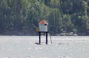
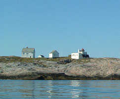
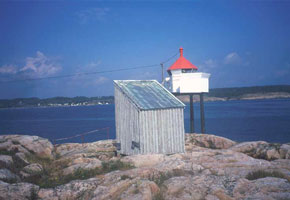
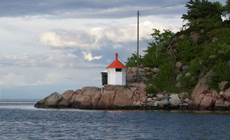
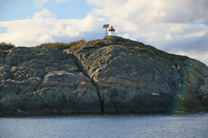
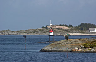
Mejulen
Øyas Tonerleia north west side (B 2674) [050600]
Photo courtesy Anders Nygaard [Flickr] |
|
NO 167
[NO 53V] |
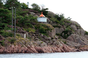
Vittenskjul |
Øyas Tonerleia north east side (B 2678) [050900] |
NO 168
[NO 53W] |
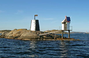
Store Fluer |
Øyas Tonerleia north point (B 2682) [051100] |
NO 169
[NO 53X] |
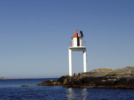
Risøy East Point |
On the east point at Risøy (B 2682.6) [051200] |
NO 170
[NO 53Y] |
Sundgårdsholmen |
at holmens on the north side (B 2686) [051900] |
NO 171
[NO 53Z] |
Skjensundet |
Blandkjernoddens southeast side. Should be visible from the Kragerø-Langøy ferry shortly after it leaves Langøy. (B 2692) [052100] |
NO 172
[NO 54] |
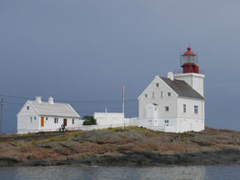
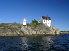
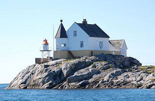
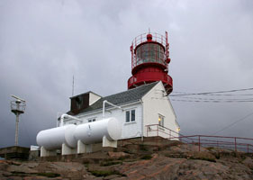
Jomfruland (1839) (Range Rear)
Jomfruland is a low island, a glacial moraine, lying parallel to the coast of the Skagerrak off the mouth of the Kragerøfjord. The old tower now houses a lighthouse museum, and the adjoining keeper's house is an art gallery. museum [052100] ARLHS # NOR-313 |
|
NO 173
[NO 55] |
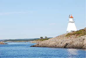
| Jomfruland (1938) (Range Rear)
The range guides ships approaching the Kragerøfjord and Kragerø; the continuous light also aids ships sailing toward Oslo. Located near the center of the island; transportation is available from Kragerø. (B 2698) [052500] ARLHS # NOR-025
Photo courtesy Ronald Wöhrn [ListOfLights] |
NO 174
[NO 56] |
Djupodden (Jomfruland Range Front) |
Located on the coast of Jomfruland about 3/4 mi southwest of the lighthouse. (B 2696) [052600] |
NO 175
[NO 61] |
Kragerø Havnefyr (Galeiodden)
Located on the eastern tip of the rocky islet of Galeiodden, in Kragerø harbor. Accessible only by boat, but there should be a good view from the ferry between Kragerø and Slatøy. (B 2714) [053800]
Photo courtesy Ronald Wöhrn [ListOfLights] |
|
NO 176
[NO 60] |
| Buttebåen
Located in the Kragerøfjorden off the western tip of the island of Slatøy. Accessible only by boat, although there is probably a good view from the island. (B 2710) [53300]
Photo courtesy Ronald Wöhrn [ListOfLights] |
NO 177
[NO 59] |
Stavseng (Strømtangen Range Rear)
Located on the south coast of Tåtøy, an island in the mouth of Kragerøfjorden. The island is accessible by ferry from Kragerø. (B 2708.1) [053200] ARLHS # NOR-226
Photo courtesy Ronald Wöhrn [ListOfLights] |
|
NO 178
[NO 58] |
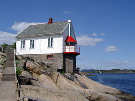
| Strømtangen (Range Front)
This is both a directional light and the front light of a range, with the Stavseng lighthouse being the rear light. Located on a point of land at the west entrance to the Kragerøfjorden. Don't confuse this with the lights in the SouthEast. NO 10 (B 2708) [053100]
Photo courtesy Alex Trabas [listOfLights] |
NO 179
[NO 57] |
Knubbehausen |
Located in the Skagerrak about 1.5 km southeast of the entrance to the Kragerøfjorden. Accessible only by boat. (B 2716) [053000] |
Aust/Agder County
NO 181
[NO 62] |
Grønholmskjær |
Located on a rocky islet about 6.5 km northeast of Risør. (B 2720) [054300] ARLHS # NOR-355 |
NO 184
[NO 63] |
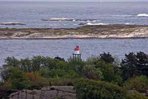
Stangholmen (1855)
The house is now a restaurant. Located on a small island about ¾ mi east of Risør. Accessible only by boat. [054300] ARLHS # NOR-223 |
|
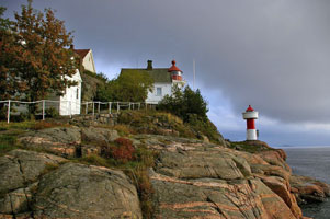
NO 185
[NO 64] |
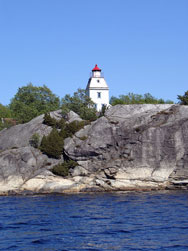
Stangholmen (1959) |
Located in front of the historic lighthouse in the photo above. (There are 4 lights called Stangholmen in Norway, so be careful when looking for this light.) (B 2722) [054500] ARLHS # NOR-318
Photo courtesy Roar Stavelin, Risør, Norway [Flickr] |
NO 186
[NO 64F] |
Store Furuøya |
Risør Øyas northeast point (B 2624) [054600] |
NO 187
[NO 65] |
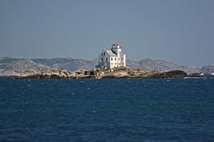
Lyngør
Located on a small islet at the entrance to Lyngørfjorden, about 8 km southwest of Risør. Accessible only by boat. (B 2740) [056600] ARLHS # NOR-292
Photo courtesy Carl Christensen [Flickr] |
|
NO 188
[NO 65B] |
Tøkersfjell (rear range) |
South of Hellersøya (B 2742.1) [056800] |
NO 190
[NO 69A] |
Sagesund |
North side of Tvedestrand, just off highway 411 west of the village. (B 2768) [058600] |
NO 193
[NO 67] |
Gråviktangen |
Located on a promontory on the east side of the Sandøyfjord, south of Apalen. (B 2767) [058500] ARLHS # NOR-354 |
NO 195
[NO 68] |
Tverrdalsøya |
Located on a promontory at the easternmost point of Tverdalsøy, about 1 mi east of Kilsund. (B 2760) [058200] ARLHS # NOR-356 |
NO 196
[NO 66] |
Ytre Møkkalasset
The tower remains in service as a daybeacon. Located on a skerry off the coast near the entrance to the Sandøyfjord, east of Kilsund. Accessible only by boat. [057300] ARLHS # NOR-284
Photo courtesy Geir Røsset [Flickr] |
|
NO 197
[NO 69] |
| Kilsund (Tverrdalsøya South Range Rear)
Located 834 m west southwest of the Holmesund front light. (B 2758) [058000] ARLHS # NOR-357
Photo courtesy Roald Hanssen [Arendal] |
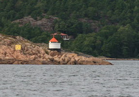
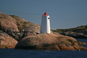
NO 198
[NO 70] |
Bonden |
A short rubblestone tower seen in front of this light is almost certainly an older light tower or daybeacon. Located on a rocky islet about 2.5 km east of the eastern end of the island of Tromøy. (B 2776) [060000] ARLHS # NOR-349 |
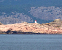
NO 199
[NO 71] |
Skinnfelltangen
Located on a promontory on the north side of the entrance to Tromøysund, opposite the Gitmertangen lights. The sound entrance is about 500 m wide. (B 2786) [060700] ARLHS # NOR-361
Photo courtesy Roald Hanssen [Arendal] |
|
NO 201
[NO 74] |
Gitmertangen North Range Rear
The front light, 234 m northeast, is probably similar; NGA describes both lights as "iron huts." Located near the eastern end of the island of Tromøy, northeast of Arendal. (B 2784) [060600] ARLHS # NOR-309
Photo courtesy Alex Trabas [ListOfLights] |
|
NO 202
[NO 73] |
Gitmertangen South Range Rear |
The Gitmertangen North and South Rear lights have a common front light and are only about 60 m apart. Located near the eastern end of the island of Tromøy, northeast of Arendal. (B 2780) [060400] ARLHS # NOR-352 |
|
|
NO 205
[NO 80] |
Sandvigodden (1844)
The building is now a private residence. Located on the west side of the entrance to the Galtesund, which leads to Arendal; this is at the southeast corner of the island of Hisøy. Accessible by road. [061600] ARLHS # NOR-317
Photo courtesy Geir Røsset [Flickr] |
|
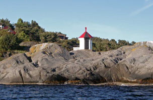
NO 203
[NO 75] |
| Frisøya
Located on the north (mainland) side of Tremøysund in Eydehamn, about 7 km northeast of Arendal. (B 2792) [061200] ARLHS # NOR-350
Photo courtesy Roald Hanssen [Arendal] |
NO 204
[NO 75T] |
Tromøysundet |
By Broneset. Very near the bridge where highway 409 connects to highway 410 north of Gjerstad. (B 2794) [061300] |
NO 207
[NO 79] |
Merdøy
Located near the west end of Merdøy, an island off the entrance to Arendal. A popular day-trip location, the island is accessible by passenger ferry from Arendal. (B 2802) [061600] ARLHS # NOR-359
Photo courtesy Ronald Wöhrn [ListOfLights] |
|
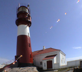
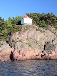
NO 208
[NO 77] |
| Lille Torungen (1844)
latitude 8° 24' 43.8" N longitude 8° 47' 29.2" E
The lighthouse can be leased for special events. Located to the east of the Store Torungen Fyr, near the eastern end of the island. [061400] ARLHS # NOR-157
Photo courtesy Jan Roger Wilkens [Flickr] |
NO 209
[NO 78] |
Lille Torungen (1914)
latitude 58° 24' 39.2" N longitude 8° 47' 37.3" E
This is the only active light on this island. It is located at the southeastern point of the island. (B 2800) [061500] ARLHS # NOR-314
Photo courtesy Jan Roger Wilkens [Flickr] |
|
NO 210
[NO 76] |
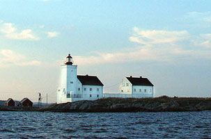
| Store Torungen
latitude 58° 23' 55.8" N longitude 8° 47' 24.6" E
The original tower was a twin of the Lille Torungen lighthouse. This (second) handsome lighthouse serves coastal navigation and also marks the entrance to Arendal. Located on a small island about 3 km southeast of the mainland and 5 km southwest of Tromøy. Accessible only by boat. (B 2798) [061400] ARLHS # NOR-040
Photo courtesy Dag Terje [Flickr] |
NO 217
[NO 84] |
Vessøyhouet (Range Rear)
Located on a promontory at the entrance to Grimstad harbor. (B 2844) [065400]
Photo courtesy Alex Trabas [ListOfLights] |
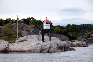
|
NO 220
[NO 83F] |
Tvillingholmen East (Vessøyhauet Range Front) |
Front range for the light below. (B 2846) [065300] |
NO 221
[NO 82] |
Rivingen (1886) (Grimstad)
The old light is now a private summer residence. Located on a small island on the approach to Grimstad, about 2.5 km south of the town and 1 km off the coast of the mainland. [65000] ARLHS # NOR-186
Photo courtesy Ronald Wöhrn [ListOfLights] |
|
NO 223
[NO 81X] |
Stangholmen |
Near Grimstad on Holmens south point. Not to be confused with the light near Risør NO 184 (B 2840) [065000] |
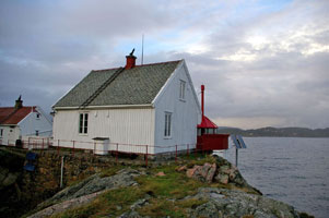
NO 224H
[NO 85] |
| Havnespynten
Located at the end of the peninsula sheltering the east side of the harbor of Jortveit. (B 2860) [066600] ARLHS # NOR-311
Photo courtesy Geir Røsset [Flickr] |
NO 225
[NO 86] |
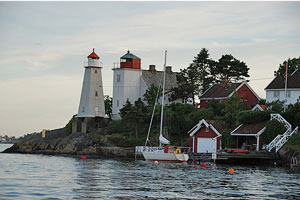
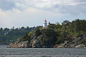
Homborsund
Sibling of the Lyngør lighthouse and built in the same year. Located on Store Gronningen, a small island about 1.5 km southeast of Jortveit. NO 187 (B 2860) [066500] ARLHS # NOR-124
Photo courtesy Mnemonic [Flickr] |
|
NO 230
[NO 86S] |
Gåsa
East of Lillisand. (This doesn't look to me like it qualifies as a lighthouse, but it is so listed.) (B 2874) [067400]
Photo courtesy Ronald Wöhrn [ListOfLights] |
|
NO 231
[NO 87] |
| Saltholmen (1882)
The building is a private summer residence. Located on a small island the entrance to Lillesand, about 2 km southeast of the town. Accessible only by boat. [007400] ARLHS # NOR-198
Photo courtesy Geir Røsset [Flickr] |
NO 235
[NO89G] |
Ågerøya
latitude 58° 10' 41.1" N longitude 8° 18' 58.3" E |
By Rabodden (B 2892) [068800] |
NO 236
[NO90] |
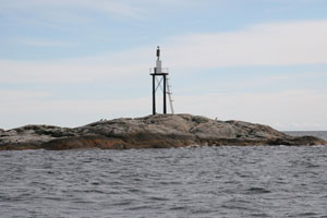
Kvalsholmen (Range Front)
latitude 58° 8' 40.2" N longitude 8° 16' 59.4" E |
Located on a tiny island about 600 m south of Ramsøy. Accessible only by boat. photo (B 2899.9) [069300] ARLHS # NOR-395 |
NO 237
[NO91] |
Natvigtangen (Range Rear)
latitude 58° 8' 2.4" N longitude 8° 15' 19.8" E |
Located on a promontory at the southern entrance to the Isefjaerfjorden. (B 2900) [069700] |
|
|
NO 238
[NO91S] |
Svervikodden
latitude 58° 7' 49.2" N longitude 8° 15' 5.9" E |
Sundets west side (B 2900.1) [069800] |
NO 239
[NO 92] |
Spaknesskjærane
latitude 58° 7' 55.8" N longitude 8° 15' 35.7" E |
Located on a rock on the south side of the Ramsøysund east of Nattvik. [069900] ARLHS # NOR-362 |
Kristiansand Area
Map is S1
NO 243
[NO 92B] |
Torsøy
latitude 58° 6' 2.8" N longitude 8° 8' 34" E |
Randøysund Øyas east side (B 2908) [070800] |
NO 244
[NO 92G] |
Mannevikodden
latitude 58° 6' 34.2" N longitude 8° 6' 51.7" E |
Sundets north side (B 2914) [070900] |
NO 245
[NO 92K] |
Stokken
latitude 58° 6' 53.6" N longitude 8° 6' 8.9" E |
Randøysund Øyas northwest point (B 2918) [071100] |
NO 246
[NO 92L] |
Ledholmen
latitude 58° 6' 33.3" N longitude 8° 5' 16.3" E |
Holmens north point (B 2920) [071500] |
NO 247
[NO 95] |
Odderøya (1874)
latitude 58° 7' 51.6" N longitude 8° 32.9" E
Located at the end of the Odderøya peninsula, which projects into Kristiansandsfjorden and protects the harbor of the city. [071800] |
|
NO 249
[NO 96G] |
Gleodden
latitude 58° 8' 49.7" N longitude 8° 2' 17.2" E |
East of Kristiansand Center (B 2940) [072600] |
NO 251
[NO 93] |
Grønningen
latitude 58° 4' 53.3" N longitude 8° 5' 17.6" E
This lighthouse marks the start of the channel into Kristiansand. During the summer the house is operated as a hostel for overnight stays, first come first served, no private accommodations. Located on a small skerry in the entrance to Kristiansandsfjorden, about 3 km south of Fidje. hostel (B 2922) [071600]
Photo courtesy Alex Trabas [ListOfLights] |
|
NO 254
[NO 94] |
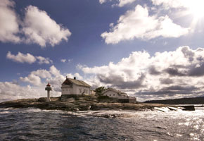
| Oksøy
latitude 58° 4' 20.2" N longitude 8° 3' 11.1" E
This historic station, the landfall light for Kristiansand, was staffed until 2004. The Oksøy and Grønningen lights bracket the entrance to the fjord. Located on a small skerry in the entrance to Kristiansandsfjorden, about 3 km east of Skålevik and the same distance west southwest of Grønningen Fyr. (B 2926) [071700] ARLHS # NOR-036
Photo courtesy Geir Røsset [Flickr] |
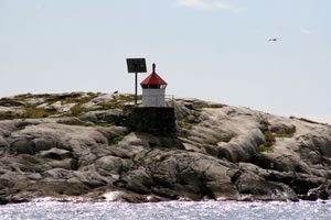
NO 261
[NO 101] |
Songvår (1888)
Long abandoned, this light station has recently been restored by the town of Søgne and is now available for overnight stays. Located on a small island about 5 km south of Søgne. [073900] ARLHS # NOR-219
Photo courtesy license via [Wikipedia] |
|
NO 263
[NO 102D] |
Nordre Vassøy |
Songvårfjorden Øyas east side (B 2966) [074300] |
NO 266
[NO 102L] |
Langøy |
Tregde - Mandal north side. Don't confuse this with Langøy in the Farsund fjord. NO 291 (B 2976) [076400] |
NO 269
[NO 103] |
Ryvingen
The first Norwegian lighthouse to be converted to electricity (1890s). The station was staffed until 2002; then it was transferred to the town of Mandal, which has restored the buildings and made them available for overnight accommodations. Located on an island about 5 km southeast of Mandal. Transportation including day trips can be arranged in Mandal. [079000] ARLHS # NOR-191
Photo courtesy Marco Ruffatti [Flickr] |
|
Lindesnes Area
NO 270
[NO 104] |
| Hatholmen
Located on an island in Mannefjorden about 1.5 km south of Mandal. The buildings are open to paying guests. courtesy François la Poutré photo [079100] ARLHS # NOR-108 |
NO 271
[NO 105] |
Sjøsanden
Sjøsanden, on the west side of the entrance to the harbor of Mandal, is Norway's only sand beach. Located behind the beach. (B 3020) [079200]
Photo courtesy kanelstrand [Flickr] |
|
NO 272
[NO 105D] |
Indre Mannevær |
In the Hillesund fjord, on the west point (B 3034) [080500] |
NO 275
[NO 105G] |
Gjallaråsholmen (front range) |
West innlop to Hillesund (B 3040) [080700] |
NO 275R
[NO 105J] |
Gjallaråsen (rear range) |
West innlop to Hillesund (B 3040.1) [080800] |
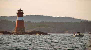
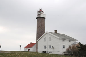
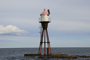
NO 280
[NO 107] |
| Lindesnes (Range Rear)
latitude 57° 58' 57.2" N longitude 7° 2' 48.3" E
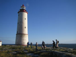
This is one of Norway's best known and most historic lighthouses, marking the southernmost point of the Norwegian mainland and the entrance to the Skaggerak and the Baltic Sea from the North Sea. Located at the end of a peninsula (the Naze) about 12 km southwest of Høllen. Accessible by paved road (highway 460). [082200] ARLHS # NOR-028
Photo courtesy François la Poutré [World Lighthouse Society] |
NO 281
[NO 107L] |
Lypskjer
latitude 58° 19.4" N longitude 7° 37.3" E |
East of Klevholmen (B 3060) [082300] |
NO 283
[NO 109] |
Revøysundet
latitude 58° 1' 42" N longitude 7° 12.4" E |
Located on an island marking a western entrance to the Grønsfjord about 8 km south southwest of Skomrak. There is a bridge to the island, but the light appears to be accessible only by boat. (B 3063) [082800] ARLHS # NOR-339 |
NO 284
[NO 110] |
Hausvigodden |
Located on the east side of the entrance to the Rosfjord about 8 km southwest of Skomrak. It is not clear if there is land access to the lighthouse. (B 3068) [083200] ARLHS # NOR-330 |
NO 285
[NO 108] |
Markøy |
Located on an island in the mouth of the Grønsfjord, about 3.5 km west northwest of Lindesnes Fyr. The island is a bird sanctuary. [082400] ARLHS # NOR-164 |
NO 286
[NO 110D] |
Syrhovud
latitude 58° 5' 55" N longitude 7° 1' 25" E |
At neset Syrhovud (B 3070) [083300] |
Farsund Area
NO 291
[NO 110S] |
Langøy |
Farsund Øyas west side. Don't confuse this with Langøy near Tregde NO 266 (B 3078) [083900] |
NO 293
[NO 111] |
Søndre Katland
Unoccupied since 1947, the lighthouse appears to be in need of restoration. Located on an island in the mouth of the Lyngdfjorden about 4.5 km southeast of Farsund. (B 3080) [084100] ARLHS # NOR-240
Photo courtesy Alex Trabas [ListOfLights] |
|
NO 294
[NO 111S] |
Sandøy
latitude 58° 3' 30.8" N longitude 6° 49' 7" E |
Sandøy south point (B 3081) [084300] |
NO 295
[NO 112] |
Eivåg (Lille Eigerøy)
latitude 58° 4' 0.8" N longitude 6° 49' 27.8" E |
Lille Eigerøy is a 10 acre island at the western entrance to Farsund. The island is privately owned and was for sale in 2006. Located at the south point of the island. (B 3086) [084500] |
NO 296
[NO 113] |
Listerrauna
latitude 58° 3' 34.2" N longitude 6° 40' 13" E |
Located on an island about 2.5 km southeast of Vestbygda. (B 3102) [085900] ARLHS # NOR-335 |
NO 297
[NO 114] |
Brekneholmen (Borhaug)
latitude 58° 5' 39.9" N longitude 6° 35' 3.4" E
Brekneholmen is actually a rocky ridge that provides a natural breakwater for the harbor of Vestbygda. Located at the south end of the island, just off Vestbygda; accessible by a causeway connecting the island to the town. (B 3106) [086000] ARLHS # NOR-327
Photo courtesy Alex Trabas [ListOfLights] |
|
NO 298
[NO 115 ] |
| Lista
latitude 58° 6' 33.4" N longitude 6° 34' 1.2" E
This light station marks a prominent and dangerous cape on the south side of the entrance to the Listafjord; from a mariner's point of view this is the extreme southwestern tip of Norway. Located just off highway 43 about ½ mi west of Vestbygda. (B 3112) [086500] ARLHS # NOR-029
Photo courtesy Mats Haugan [Flickr] |
NO 299
[NO 116] |
Varnes |
This little light, a companion to the Lista Fyr, marks the south side of the entrance to the sheltered waters of the Listafjord. Located off highway 654 about 10 km north of Lista Fyr; accessible by a narrow and twisting road. (B 3118) [087300] ARLHS # NOR-269 |
NO 300
[NO 116D] |
Skarvehellaren |
Innseiling til Fedafjorden (B 3120) [087400] |
NO 301
[NO 116E] |
Fedefjord |
East of Feda just off E39 as it crosses the Fjord. (B 3122) [087600] |
NO 302
[NO 116J] |
Risholmsund |
Probably visible from the Sbelsnes to Andabeløy ferry. (B 3125) [087900] |
NO 304
[NO 116S] |
Bolshus |
West of Bjørnøyane in Stolsfjorden (B 3127) [088000] |
NO 308
[NO 117] |
Kirkehavn |
Kirkehavn is a village on the Hidrasundet on the west end of the island of Hidra. Located on the north side of the harbor entrance of Kirkehavn, near the church. (B 3140) [089900] |
|
|
 Southwest Norway
 Southeast Norway
