|
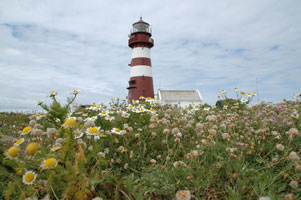
This page shows the documentation of the Lighthouses of Southwest Norway. You can always click on the photo of the light to go to a specific (larger resolution) copy. Each lighthouse name is linked to (in our editorial opinion) the best reference site for that light. I would like to include directions on how to get to these lights. If you know such data, could you eMail me and I'll post it here (with your choice of attribution.) mailme There has been significant usage of the Lighthouse Directory prepared by Russ Rowlett (UNC). lhDirectory. Lighthouse coord Lighthouse coordinates and orange reference numbers are via Norsk Fyr. My thanks to them for providing this basis for understanding. p6 |
|
Utsira, Feøy and Røvaer
NO 313
[NO 173] |
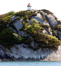
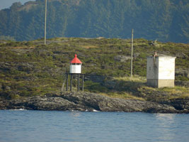
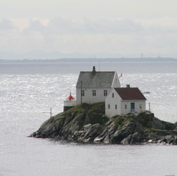
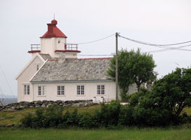
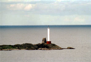
Røværsholmen |
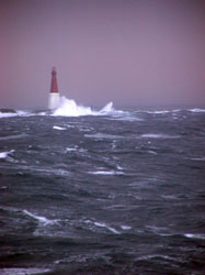
The lighthouse is built as a wave swept tower, since winter storms often wash over the islet on which it is built. Located on a small skerry about 800 m northwest of the larger island of Røvaer and about 12 km west northwest of Haugesund. Accessible only by boat in heavy seas; there is a distant view from Røvaer, which is accessible by passenger ferry from Haugesund. (B 3570) [132900] ARLHS # NOR-373 |
NO 314
[NO 172T] |
Torgersnes
latitude 59° 26' 5.6" N longitude 5° 5' 37.4" E |
Røværs east side (B 3568) [132500] |
NO 315
[NO 172R] |
Gloppene
latitude 59° 25' 44.5" N longitude 5° 7' 38.3" E |
At Gloppene, southeast of Røvær (B 3566) [132400] |
NO 316
[NO 172P] |
Glette
latitude 59° 25' 28.1" N longitude 5° 7' 31.5" E |
At Glette, southeast of Røvær (B 3564) [132300] |
NO 317
[NO172H] |
Kvaløytåi
latitude 59° 24' 11.9" N longitude 5° 9' 27.4" E |
Kvaløy north point (B 3556) [131600] |
NO 318
[NO172G] |
Middagsnes
latitude 59° 22' 35.9" N longitude 5° 8' 53.5" E |
Feøy southwest side (B 3554) [131300] |
NO 319
[NO172F] |
Flatmøy
latitude 59° 22' 27" N longitude 5° 11' 58.3" E |
On a rock in Føynfjorden. Accessible only by boat. (B 3548) [131100] |
NO 320
[NO172] |
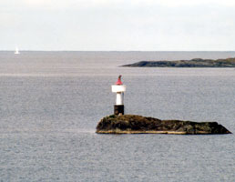
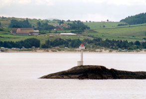
Feøy |
Feøy is an island about 5 km northwest of Visnes, Karmøy. The island has a population of about 60 and is accessible by passenger ferry from Haugesund. Located on the southeastern point of the island. (B 3546) [131000] ARLHS # NOR 077 |
NO 321
[NO 171] |
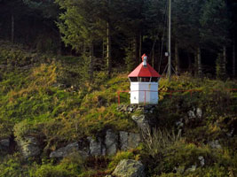
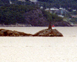
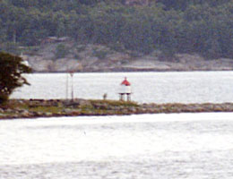
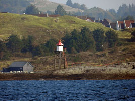
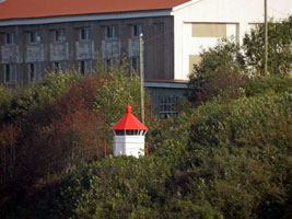
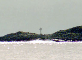
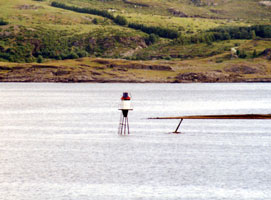
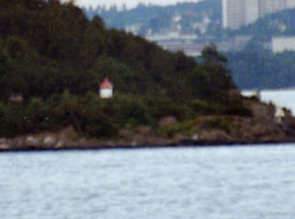
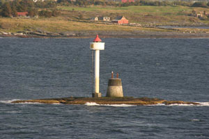
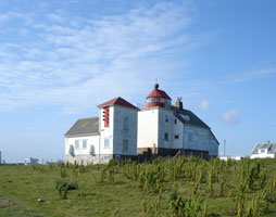
Beiningskalven
Located atop Beiningskalven, an islet off the east coast of Beiningen, an inhabited island about 600 m south of Utsira's main waterfront on the south coast of the island. Accessible only by boat. (B 3544) [129900]
Photo courtesy Alex Trabas [liteslist] |
|
NO 322
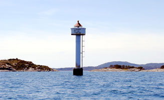
[NO 168] |
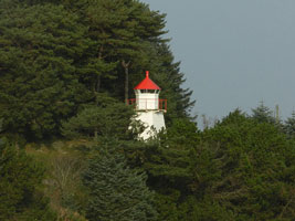
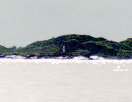
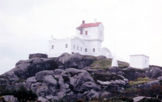
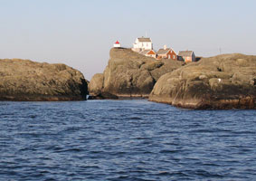
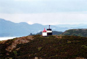
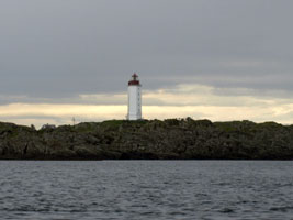
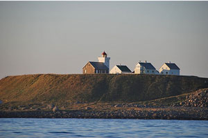
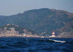
| Utsira north tower
According to the Lighthouse Association, this is a staffed station with several 1-story keeper's houses. The lighthouses are located at the east end of the island. [124600] ARLHS # NOR-262
Photo courtesy Eirik Newth [Flickr] |
NO 323
[NO 167] |
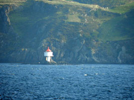
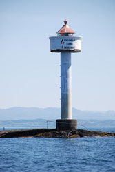
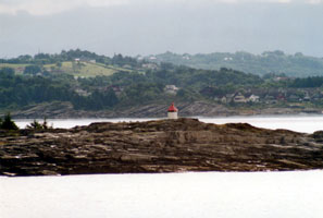
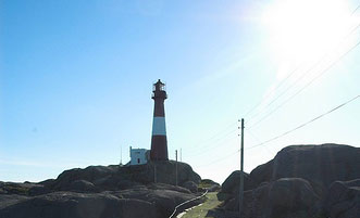
Utsira (south tower)
Utsira is an island about 2.5 km long and 1.2 km wide, located in the North Sea 18 km west southwest of Haugesund. The island is accessible by passenger ferries from Haugesund. This tower is located about 100 m south of the north tower (next entry). (B 3540) [124600] ARLHS # NOR 344
Photo courtesy Eirik Newth [Flickr] |
|
Karmøy and Haugesund Area
NO 325
[NO 166] |
| Kvalen
latitude 59° 25' 58.9" N longitude 5° 14' 20" E
Located on a headland at the north side of the entrance to the Karmsund about 1.5 km northwest of Haugesund harbor. Not to be confused with several other lights like Kvalen light in Northern Hordaland. NO 590
or NO 449 (B 3490) [124600]
Photo courtesy Mike Boucher [ListOfLights] |
NO 326
[NO 164] |
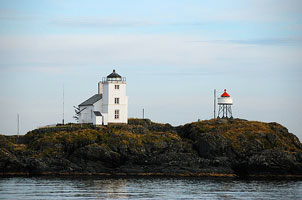
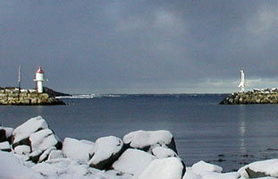
Sørhaugøy (1846) (Tonjer)
The lighthouse is vacant but has been restored by the Culture Ministry. Located on a small island in the north entrance to the Karmsund, about 400 m offshore northwest of Haugesund. Accessible only by boat. [124500] ARLHS # NOR-243
Photo courtesy Geir Røsset [Flickr] |
|
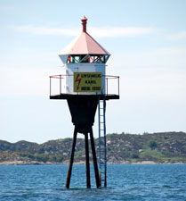
NO 327
[NO 165] |
Sørhaugøy (1952) (Tonjer)
latitude 59° 25' 25.8" N longitude 5° 14' 24.2" E |
As can be seen in the picture above, located immediately in front of the historic lighthouse. (B 3488) [124500] ARLHS # NOR-340
Photo courtesy Geir Røsset [Flickr] |
NO 328
[NO172K] |
Kråkene
latitude 59° 25' 13.7" N longitude 5° 12' 34.8" E
At Kråkene, north of Karmøy (B 3558)
Photo courtesy Mike Boucher [ListOfLights] |
|
NO 329
[NO 163V] |
| Vestre Karmsund
latitude 59° 24' 57.6" N longitude 5° 13' 59" E
Steinskjæret northwest of Haugesund (B 3486) [124300]
Photo courtesy Mike Boucher [ListOfLights] |
NO 332
[NO 163N] |
Rossebønakken
latitude 59° 23' 35.5" N longitude 5° 17' 5.7" E
Haugesund south (B 3448) [121600]
Photo courtesy Mike Boucher [ListOfLights] |
|
NO 333
[NO 163H] |
| Salhus
latitude 59° 22' 30.3" N longitude 5° 17' 39.2" E
Just north of the Highway 47 bridge in Salhus. (B 3442) [121400]
Photo courtesy Mike Boucher [ListOfLights] |
NO 335
[NO 163A] |
| Snikspynten
latitude 59° 20' 56.8" N longitude 5° 18' 57.4" E
South of Vormedal in Karmsundet (B 3438) [121200]
Photo courtesy Mike Boucher [ListOfLights] |
NO 336
[NO 163] |
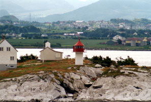
Høyevarde (Høgevarde)
latitude 59° 20' 1.4" N longitude 5° 18' 55.8" E
Located on a promontory at Avaldsnes on the east side of Karmøy (and the west side of the Karmsund, which separates Karmøy from the mainland). (B 3436) [120900] ARLHS # NOR-127
Photo courtesy Ane Steingildra Alvestad [Flickr] |
|
NO 337
[NO 170] |
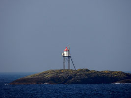
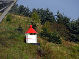
| Vindballen
Located on a rocky islet off the south coast of Utsira. Accessible only by boat. (B 3541.4) [129800] ARLHS # NOR-277
Photo courtesy Alex Trabas [listOfLights] |
NO 338
[NO 169] |
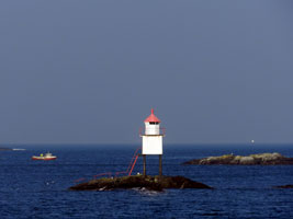
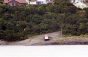
Nordvikvågen Breakwater (Nordevågen)
Located at the end of the breakwater for the Nordvikvågen harbor on Utsira's north coast. (B 3541) [129600]
Photo courtesy Atle Grimsby [Flickr] |
|
NO 339
[NO 150] |
| Kallstø
latitude 59° 20' 18.4" N longitude 5° 11' 20.6" E
Located on the west side of Karmøy about 5 km southwest of Visnes. (B 3536) [129200] ARLHS # NOR 447
Photo courtesy Thor Hakonsen [Flickr] |
NO 340
[NO 151] |
Veavågen
latitude 59° 18' 25.3" N longitude 5° 12' 56.9" E |
Located on the north side of the entrance to the narrow fjord leading to Vedavågen, about 5 km northwst of the town. (B 3534) [129100] |
NO 341
[NO 152] |
Marøy
latitude 59° 16' 36.1" N longitude 5° 10' 46.6" E |
Located on a promontory about 1.5 km north of Åkrehamn, on the west coast of Karmøy. (B 3532) [129000] ARLHS # NOR-164 |
NO 342
[NO 153] |
Åkrehamn
latitude 59° 15' 25.6" N longitude 5° 10' 39.5" E |
In Åkrehamn harbor, this is a common rear and front range (B 3527) [127800] |
NO 343
[NO 154] |
Åkrehamn Nedre (rear range)
latitude 59° 41' 18.7" N longitude 5° 10' 58.2" E |
Located on the waterfront of Åkrehamn. (B 3527.1) [128100] |
NO 344
[NO 155] |
Ferkingstad Molja |
Located at the end of the breakwater mole in Ferkingstad, on the west coast of Karmøy. (B 3524) [127521] |
NO 345
[NO 156] |
Ferkingstadneset |
Located on a promontory about 1 km southwest of Ferkinstad harbor. (B 3523) [127500] |
NO 347
[NO 156J] |
Jarsteinen |
Karmøy south or southwest side, Øyas NE side. (B 3520) [126800] |
|
|
NO 348
[NO 157] |
Syrevågen |
Located at the end of the mole at Syrevågen, about 2 km west of Skudeneshavn. (B 3516) [126600] |
NO 350
[NO 158] |
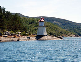
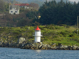
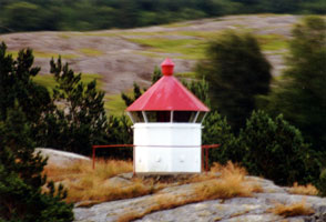
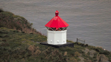
Geitungen
This lighthouse was built in response to complaints that the Kvistøy lighthouse was too far east to provide an effective landfall light for Stavanger. It is located at the end of the mole at Syrevågen, about 2 km west of Skudeneshavn. (B 3514) [126500] ARLHS # NOR-016
Photo courtesy Alex Trabas [listOfLights] |
|
NO 351
[NO 159] |
| Vikaholmen (1875)
Originally the station had a small light tended as needed by local fishermen. It is now available for overnight rental. Located on a small island about 800 m south of the harbor of Skudenshavn. [126500] ARLHS # NOR-347 |
NO 353
[NO 161] |
Skudenes
These buildings are privately owned. Located on a promontory on the southeastern point of Karmøy and the on the east side of the harbor of Skudeneshavn. (B 3503) [125400] ARLHS # NOR-212
Photo courtesy Ane Steingildra Alvestad [Flickr] |
|
NO 354
[NO 147Z] |
Smørstakk |
East side of sundet, northwest of Vestre Bokn (B 3428) [120400] |
NO 355
[NO 162] |
Kopervik (Kobbernaglen)
Located on a rocky reef in the entrance to the harbor of Karmøy. Accessible only by boat. (B 3430) [120500] ARLHS # NOR-140
Photo courtesy Mike Boucher [ListOfLights] |
|
NO 363
[NO 147W] |
Drivsund |
South of Vestre Bokn, Krabbeskjer. (B 3420) [119700] |
NO 364
[NO 147X] |
Klepp |
South of Vestre Bokn, Kjølevikneset (B 3422) [119900] |
NO 370
[NO 146T] |
Toftøy
latitude 59° 15' 45.2" N longitude 5° 40' 8.6" E |
By Toftøyas south point (B 3358) [114500] |
NO 372
[NO 146V] |
Nedstrand |
Tanganeset south of Nedstrand. May be visible from the Jelsa to Judaberg ferry just before you arrive in Nedstrand. (B 3368) [115000] |
NO 377
[NO 147] |
Hamborneset (Hamborgneset) |
Located at a bend in the Sandfjord, on the south side of the fjord, about 8 km southwest of Sand. (B 3384) [115800] |
NO 378
[NO 146Z] |
Ottøya |
Off the northwest point of Sandsfjord. (B 3376) [115300] |
NO 379
[NO 146Y] |
Kviteholmen |
South of Skorpene in Sandsfjord (B 3372) [115200] |
|
|
Klepp Area
NO 387
[NO 146K] |
Jøsneset |
Should be visible on the south side of route 13 east of Nesvik. (B 3338) [112900] |
NO 389
[NO 146Q] |
Ombo |
Near Ombos on the west side at Ryfylkefjordane (B 3350) [113900] |
NO 393
[NO 146P] |
Øksnes |
May be visible from the Jelsa to Judaberg ferry. (B 3346) [113800] |
NO 395
[NO 146A] |
Langholmen |
On Point near Nordskor in Årdalsfjord. This is another common name, don't confuse with NO 1617
or NO 1257 (B 3332) [112500] |
NO 396
[NO 146] |
Talgje SE Point |
On the west side of Nedstrandfjord. There is another light on the E point as well (B 3354). (B 3322) [115100] |
NO 400
[NO 139] |
Fjøløy
latitude 59° 5' 20.2" N longitude 5° 34' 7.6" E
The original lighthouse was demolished. Located on the southwest side of Fjøløy, an island directly across the Kvitsøyfjord from the Tungenes lighthouse. The island is accessible from Stavanger by the Byfjord Tunnel and a series of bridges. (B 3258) [104800] ARLHS # NOR-081
Photo courtesy Roar Johansen [Wikipedia] |
|
NO 401
[NO 145V] |
Linesund |
On a skerry in Lineundets east side. (B 3311) [111000] |
NO 402
[NO 137] |
Gryda
latitude 59° 2' 56.3" N longitude 5° 36' 30" E
Located in the Kvitsøyfjord about 1.5 km northeast of the Tungenes lighthouse. Accessible only by boat. (B 3264) [105600] ARLHS # NOR-329
Photo courtesy Alex Trabas [listOfLights] |
|
NO 406
[NO 145A] |
Lysefjorden |
On the north side of the fjord (B 3296) [108800] |
NO 407
[NO 145] |
Bergsholmen
Located on an island in the Lysefjord, the northern branch of the Høgsfjord, about 5 km north of Forsand. (B 3292) [108500] ARLHS # NOR-326
Photo courtesy Alex Trabas [listOfLights] |
|
NO 408
[NO 144] |
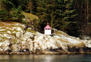
| Aspøy
Located on an island in the Høgsfjord about 4 km north of Høle. (B 3290) [108300] ARLHS # NOR-325
Photo courtesy Alex Trabas [listOfLights] |
NO 409
[NO 143] |
Tingholmen
Located on the south side of the entrance to the Høgsfjord about 5 km northeast of Hommersåk and 8 km by sea east of Stavanger. There does not appear to be land access to this location. (B 3288) [108200] ARLHS # NOR-343
Photo courtesy Alex Trabas [ListOfLights] |
|
NO 410
[NO 145L] |
| Lindøysund
Located on the north point of the island of Lindøy, in the Hillefjord about 6 km northeast of Stavanger. Accessible only by boat; the light can be seen from ferries between Stavanger and Strand. (B 3302) [109500] ARLHS # NOR-334
Photo courtesy Alex Trabas [listOfLights] |
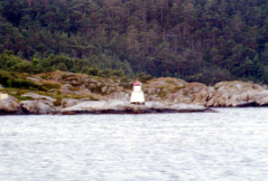
NO 412
[NO 145T] |
| Klovningen
Located on a small island southeast of Åmøy, about 5 km north northeast of Stavanger, marking the junction of the Åmøyfjord and the Hillefjord. (B 3308) [110000] ARLHS # NOR-332
Photo courtesy Alex Trabas [listOfLights] |
Stavenger Area
NO 415
[NO 140G] |
Grasholmen |
On an island underneath the Bybrua bridge from Stavanger north towards Hundvåg. Probably also visible from ferries from the east into tavanger. Flickr (B 3277.301) [107650] |
NO 416
[NO 140] |
Tjuvholmen
Located at the northwest point of a small island about 800 m northwest of the Stavanger waterfront. Accessible only by boat. (Note carefully that Norway has 3 lights named Tjuvholmen.) NO 1016 (B 3272) [106700]
Photo courtesy Rainer Arndt [ListOfLights] |
|
NO 417
[NO 138] |
| Dusaviga (Vardeneset)
Located off the Dusavikveien in Stavanger, marking the entrance to the Åmøfjord, which forms the city's inner harbor. (B 3266) [105900] ARLHS # NOR-328
Photo courtesy Alex Trabas [listOfLights] |
NO 418
[NO 135] |
Tungenes
latitude 59° 2' 8.3" N longitude 5° 34' 52.5" E
The lighthouse marked the cape at the south side of the entrance to Stavanger harbor. Located at the end of the Tungenesveien on the west side of Randaberg. [103800] ARLHS # NOR-048
Photo courtesy Therese Jåtten [Flickr] |
|
NO 419
[NO 136] |
| Bragen
latitude 59° 2' 27.8" N longitude 5° 34' 18.7" E
This light replaced the historic Tungenes lighthouse; it is located on a tiny island about 800 m northwest. Accessible only by boat. (B 3262) [105500] ARLHS # NOR-297
Photo courtesy Alex Trabas [listOfLights] |
NO 420
[NO 135B] |
Sandholmen
latitude 59° 2' 28.3" N longitude 5° 25' 18.4" E |
Kvitsøy, on the south side at holmen. (B 3253) [104300] |
NO 421
[NO 134G] |
Gjerdholmen
latitude 59° 2' 46.2" N longitude 5° 27' 11.3" E |
Located on a small island off the southeast coast of Kvitsøy. (B 3252) [103800] ARLHS # NOR-353 |
NO 422
[NO 135K] |
Kalveneset
latitude 59° 4' 30.2" N longitude 5° 23' 49.2" E |
On rocks at the northwest corner of Kvitsøy (B 3255) [104500] |
NO 423
[NO 135G] |
Piggskjeret
latitude 59° 2' 48" N longitude 5° 24' 26.4" E |
Piggskjeret, Kvitsøy (B 3254) [104400] |
NO 424
[NO 134B] |
Ystebø
latitude 59° 3' 14.1" N longitude 5° 23' 55.6" E |
North point of N. Bladøy (B 3247) [102100] |
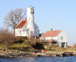
NO 425
[NO 134A] |
Kvitsøy
latitude 59° 3' 43.3" N longitude 5° 24' 0.5" E
Kvitsøy is an island about 2.5 km long and about 8 km west of the entrance to Stavanger's harbor. There is a town (Ydstebøhavn) on the island, and ferry service is available daily from Stavanger. The lighthouse is located near the west end of the island. (B 3246) [102000] ARLHS # NOR-146
Photo courtesy evensbu [Flickr] |
|
NO 426
[NO 134] |
| Vistnestangen
latitude 58° 58' 51.7" N longitude 5° 33' 56.5" E
Located at the end of the Vistnesveien on the north side of the entrance to the harbor of Kvernevik, just west of Stavanger. (B 3242) [101500] ARLHS # NOR-348
Photo courtesy Alex Trabas [listOfLights] |
NO 427
[NO 133] |
Oksafodskjer
latitude 58° 56' 49" N longitude 5° 31' 48.9" E
Located on an island about 1.5 km off the coast northwest of Tananger. (B 3241.5) [100900]
Photo courtesy Alex Trabas [listOfLights] |
|
NO 428
[NO 132] |
| Tananger
Located off the Havneveien on the north side of the entrance to the harbor of Tananger, close to the pilot station. (B 3237) [100600] ARLHS # NOR 342
Photo courtesy Tom Jervis [Flickr] |
NO 429
[NO 131] |
Flatholmen
latitude 58° 55' 20.9" N longitude 5° 33' 19.8" E
Located on an island about 1 km off the coast at Tananger. Accessible only by boat; transportaion to the island can be arranged in Tananger. (There are 6 lights in Norway called Flatholmen, so be careful when searching.) (B 3236) [100500] ARLHS # NOR-083
Photo courtesy Alex Trabas [listOfLights] |
|
NO 430
[NO 130] |
| Kolnesholmane
latitude 58° 53' 24.7" N longitude 5° 32' 38.9" E
Located on an island about 1.5 km off the coast near Sola. Accessible only by boat. (B 3232) [100200] ARLHS # NOR-331
Photo courtesy Alex Trabas [listOfLights] |
NO 431
[NO 129S] |
Sørskot
There's not a lot of definition about this light available on the web. It's near Jæren. (B 3231) [100100]
Photo courtesy Alex Trabas [listOfLights] |
|
NO 432
[NO 129] |
| Feistein
latitude 58° 49' 34.6" N longitude 5° 30' 17.6" E
Located on an island about 2 km off the coast near Verdalen. (B 3228) [100000] ARLHS # NOR-013
Photo courtesy Jarle Aabakke Tollaksen [Flickr] |
NO 433
[NO 128] |
Håtangen (Obrestad Range Front)
Located at the small harbor of Obrestad about 5 km west of Naerbø and 1 km southeast of the Obrestad lighthouse. (B 3220) [099400]
Photo courtesy Pål Berge [Flickr] |
|
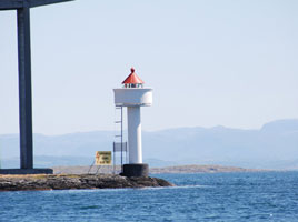
NO 434
[NO 127] |
| Obrestad (rear range)
Located on a promontory about 5 km west of Naerbø. (B 3220.1) [099000]
Photo courtesy Geir Røsset [Flickr] |
NO 435
[NO 126] |
Obrestad Havn |
Located at the small harbor of Obrestad about 5 km west of Naerbø and 1 km southeast of the Obrestad lighthouse. (B 3222) [099100] ARLHS # NOR 336 |
Eigersand Area
NO 437
[NO 124] |
Kvassheim (1912)
latitude 58° 32' 38.7" N longitude 5° 40' 54.4" E
Located on a promontory about 2.5 km south of Vigrestad. [094500] ARLHS # NOR-026 |
|
NO 438
[NO125] |
Kvassheim (1990)
latitude 58° 32' 40" N longitude 5° 40' 49.4" E |
Located a short distance north and west of the historic lighthouse. (B 3217) [098600] ARLHS # NOR-333 |
NO 441
[NO 123] |
Eigerøy
latitude 58° 25' 51.1" N longitude 5° 52' 3" E
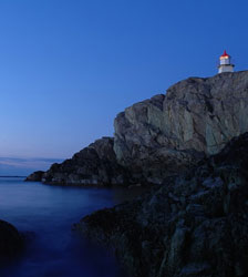
This was Norway's first cast iron lighthouse, and its success encouraged the building of many more on the Norwegian coastline. Located on the southwestern tip of Eigerøy, about 12 km west of Eigersund. Accessible by road and a strenuous walk. (B 3184) [094500] ARLHS # NOR-010
Photo courtesy Jone Fredriksen [Flickr] |
|
NO 446
[NO 119] |
Alterodden |
Located on a promontory on the east side of the Rekefjord near the end of highway 40 about 8 km southwest of Hauge. The site may not be not accessible by land but there seem to be good views from nearby. Anke and Jens photo. (B 3160) [092100] ARLHS # NOR-324 |
NO 447
[NO 120] |
Lille Prestskjær
Located on the west side of the entrance to the Rekefjord about 5 km southwest of Hauge. (B 3156) [092000] ARLHS # NOR-156
Photo courtesy Geir Røsset [Flickr] |
|
NO 448
[NO 118K] |
Kvalen Østre (east) |
Skarvøyas south point (B 3152) [093100] |
NO 449
[NO 118] |
Kvalen Vestre (Jøssingfjord) |
Perched on a cliff on the Jøssingfjord about 5 km southeast of Hauge. The site appears quite inaccessible. Not to be confused with the similar named light above. NO 325 (B 3150) [091300] ARLHS # NOR-406 |
|
|
 West (South) Norway