|
This page shows the documentation of the Central Lighthouses of West Norway. You can always click on the photo of the light to go to a specific (larger resolution) copy. Each lighthouse name is linked to (in our editorial opinion) the best reference site for that light.I would like to include directions on how to get to these lights. If you know such data, could you eMail me and I'll post it here (with your choice of attribution.) mailme I will be renumbering these lights. I apologize for any inconvenience I create while doing so.
There has been significant usage of the Lighthouse Directory prepared by Russ Rowlett (UNC). LH Directory Lighthouse coordinates are via Norsk Fyr. My thanks to them for providing this basis for understanding. p6 |
|
Kristiansund Area
Map is W2
| NO 774 |
Mevikholmen
latitude 63° 12' 41.4" N longitude 8° 9' 25.8" E |
Mevikholmen in Solemsundet (L 1144) [402600] |
| NO 775 |
Steintangskjærflua
latitude 63° 14' 0.6" N longitude 8° 8' 33.6" E |
East of Tustna (L 1142) [402500] |
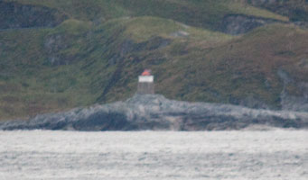
| NO 776 |
Sæterfløa
latitude 63° 10' 21" N longitude 8° 10' 45" E |
Located near the southern end of the Saeterflua, the narrow channel separating the islands of Tustna and Stabben. photo (L 1145) [402700] |
| NO 777 |
Hammarsundet
latitude 63° 12' 21" N longitude 7° 57' 41" E |
West of Tustna (L 1140) [401700] |
| NO 778 |
Stangdragsøy
latitude 63° 12' N longitude 7° 57' 6.6" E |
Located on an island off the north coast of Tustna, 3 km north of Tømmervåg. Accessible only by boat. (L 1138) [401600] |
| NO 779 |
Lindvågodden
latitude 63° 10' 44.4" N longitude 7° 54' 52.8" E |
West of Tustna (L 1134) [401000] |
| NO 780 |
Storramsøy
latitude 63° 10' 11.4" N longitude 7° 51' 32.4" E |
Tustna Southwest side (L 1130) [400500] |
| NO 782 |
Flathårskollen (Range Front) |
The range guides northbound vessels departing Kristiansund. Located about 500 m south of the Grip Fyr. Accessible only by boat. (L 1126) [389910] |
| NO 782R |
Grip (Flatharskallen Range Rear)
latitude 63° 14' 1.8" N longitude 7° 36' 33" E
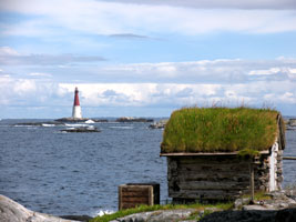
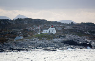
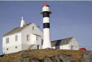
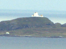
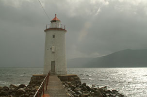
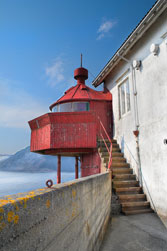
Until it was automated in 1977, this must have been one of the most difficult Norwegian stations for keepers. Located on a bare skerry, swept by the waves in every storm, about 6.5 km north of Kristiansund. Accessible only by boat in dangerous seas. (L 1126.1) [400000] ARLHS # NOR-100
Photo courtesy Erling Silversten [Flickr] |
|
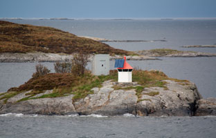
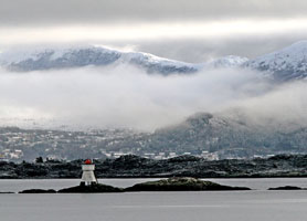
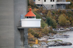
| NO 783 |
| Kvitneset
latitude 63° 7' 56.1" N longitude 7° 48' 16.4" E
October 14, 2010
Located on a promontory on the east side of a northeastern entrance to Kristiansund, about 5 km northeast of the city. (L 1046) [380100] |
| NO 784 |
Bjørnehaugen |
Sundets south side (L 1042) [379700] |
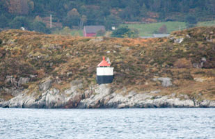
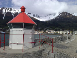
| NO 785 |
Moloen
latitude 63° 6' 20.4" N longitude 7° 43' 28.9" E
October 14, 2010
Near Moloen under Sørsundbrua (L 1038) [379000] |
|
| NO 786 |
Nordholmen
latitude 63° 6' 54.4" N longitude 7° 45' 2.1" E |
Holmens south point (L 1041) [379400] |
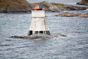
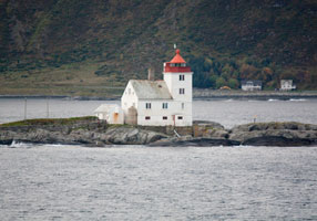
| NO 787 |
Baltserneset (Kristiansund)
latitude 63° 6' 6" N longitude 7° 43' 2.4" E
October 14, 2010
This light marks the entrance to the inner harbor of Kristiansund. Located at the west end of Innlandet south of the Kristiansund waterfront. The island is accessible by bridge and the lighthouse is accessible by road. (L 1030) [378100] |
|
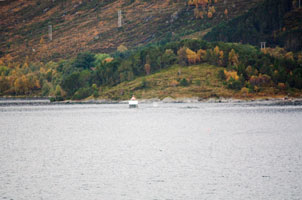
| NO 788 |
Vikaholmen
latitude 63° 6' 14" N longitude 7° 46' 1.9" E |
On the inland route, this is just before the entrance to Kristiansund (on the north side). (L 1032) [378500] |
| NO 789 |
Omsundet
latitude 63° 6' 25.4" N longitude 7° 50' 55.4" E |
Omsbrødrenes southwest side (L 1048) [381000] |
| NO 790 |
Flåøy
latitude 62° 44' 54.6" N longitude 8° 26' 43.8" E |
Located on a skerry just off the north side of the upper Tingvollfjord, about 8 km northwest of the head of the fjord at Sunndal. Accessible only by boat. (L 1068) [383600] |
| NO 791 |
Meløy |
Located atop a small island in the Tingvollfjord about 9 km southeast of Rausand. Accessible only by boat. (L 1166) [383400] |
| NO 792 |
Sognskjæret |
Tingvollfjord (L 1064) [383200] |
| NO 793 |
Kvalvågholmen
latitude 62° 58' 31.7" N longitude 7° 59' 45" E |
Bergsøyfjord (L 1062) [383000] |
| NO 794 |
Gjemnessundet |
Gjemnessundet in Nordmørefjordene (L 1059) [382100] |
| NO 795 |
Freines
latitude 63° 1' 24.9" N longitude 7° 48' 49" E |
Freifjorden (L 1054) [381700] |
| NO 796 |
Strandanes
latitude 62° 59' 9.6" N longitude 7° 41' 23.4" E |
Kvemesfjord (L 1056) [382000] |
| NO 797 |
Leitnes
latitude 63° 1' 43.1" N longitude 7° 40' 43.9" E |
Bremsnesfjord (L 1052) [381500] |
| NO 798 |
Raudsandneset
latitude 63° 4' 9.6" N longitude 7° 40' 42" E |
Bremsnesfjord (L 1050) [381400] |
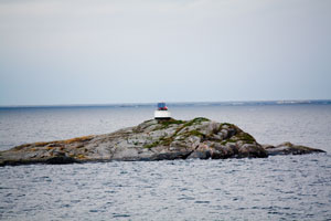
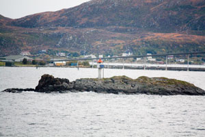
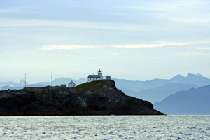
| NO 799 |
Stavenes
latitude 63° 6' 52.1" N longitude 7° 39' 46.9" E
October 14, 2010
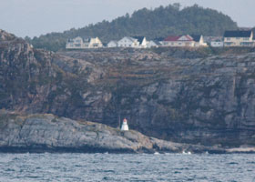
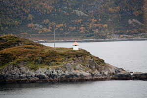
This light marks the entrance to the Sørsundet and the harbor of Kristiansund. Located at the northeastern tip of Averøya about 3 km north of Bremsnes. (There are 3 lights with this name in Norway, search carefully.) (L 1028) [378000] ARLHS # NOR-224 |
|
| NO 800 |
Sveggesundet
latitude 63° 6' 45" N longitude 7° 35' 40.8" E |
Engelens northeast point (L 1026) [376800] |
| NO 801 |
Galten
latitude 63° 5' 31.2" N longitude 7° 35' 31.2" E |
Sveggevicken, Northwest side of Averøy (L 1024) [376400] |
| NO 802 |
Hestskjaer (new)
latitude 63° 5' 4.2" N longitude 7° 29' 33" E |
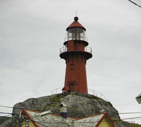
Located adjacent to the historic lighthouse. (L 1022) [375500] ARLHS # NOR-401 |
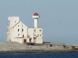
| NO 803 |
Hestskjaer (1879)
latitude 63° 5' 48" N longitude 7° 30' E
Located on a skerry about 1.4 km north of Langøy and 8 km northeast of Averøy. Accessible only by boat. ARLHS # NOR-119
Photo courtesy Aldebaran [wikipedia] |
|
| NO 804 |
Fårøyskjæret
latitude 63° 3' 55.8" N longitude 7° 31' 15.6" E |
Langøysundet, North side of Averøy (L 1021.5) [375700] |
| NO 805 |
Legrimen |
Reksundet (L 1021) [375100] |
| NO 806 |
Langbaken
latitude 63° 4' 3" N longitude 7° 28' 36" E |
West side of Averøy (L 1020) [375000] |
| NO 807 |
Gullhatten
latitude 63° 3' 5.4" N longitude 7° 24' 7.2" E |
West side of Averøy (L 1018) [373600] |
| NO 808 |
Lille Sandøy
latitude 63° 2' 57" N longitude 7° 23' 25.8" E |
West side of Averøy (L 1017) [373500] |
| NO 809 |
Flatskjaeret |
Located on a skerry marking the entrance to a sound west of Averøy. Accessible only by boat, but there must be a good view from highway 64, which crosses the sound on a series of bridges nearby. (L 1015) [372500] |
| NO 810 |
Tevikholment |
Kornstadfjorden (L 1012) [372000] |
| NO 811 |
Kongshaug |
Kornstadfjorden (L 1014) [372200] |
| NO 812 |
Kråka
latitude 63° 54" N longitude 7° 17' 48" E |
Located in the harbor of Vevang, about 6 km west of Averøy. photo (L 1006) [371000] |
| NO 813 |
Kvitholmen (1842) (Legrimen)
latitude 63° 1' 19.1" N longitude 7° 14' 10.3" E |
Located on a small island about 1.5 km offshore and about 8 km west of Averøy. The island is protected as a bird sanctuary. (L 1021) [375100] |
| NO 815 |
Kusundet |
East of Store Moldvarden (L 1000) [369700] |
| NO 816 |
Askvågen (Haugeneset) |
Located on the ocean shore about 5 km northeast of Bud. (L 0997) [369100] |
| NO 817 |
Vikan |
North of Bud (L 0274) [368200] |
| NO 818 |
Romsdalsholmen |
North of Bud. (L 0991) [368000] |
| NO 819 |
Harøyodden |
West Point Indre Harøya (L 0929) [356800] |
|
|
| NO 820 |
Hogsnes |
Gossa east side. (L 0930) [357500] |
| NO 821 |
Orholmskjæret Søre (south) |
Southwest of Bjørnsund (L 0922) [355500] |
| NO 822 |
Hammarøyskjæret |
Near South Bjørnsund (L 0920) [355100] |
| NO 823 |
Moøy (Bjørnsund) |
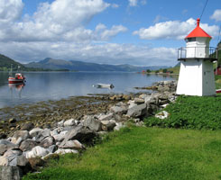
Located on an island about 4 km west of Bud; accessible by passenger ferry from Bud. (L 0918) [355000] ARLHS # NOR-057 |
| NO 824 |
Hjertøytangen
latitude 62° 42' 38.4" N longitude 7° 6' 39" E |
This light is West, and somewhat south of Molde, at the intersection of the north-south and east-west shipping routes.
West of Hjertøya (L 0950) [359700] |
| NO 825 |
Molde Havnelykt (Reknes)
latitude 62° 43' 57.3" N longitude 7° 9' 4.3" E
October 5, 2010
At the end of the west pier in Molde (L 0952) [359900] |
|
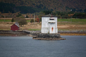
| NO 826 |
| Molde Faux Light
latitude 62° 43' 59.7" N longitude 7° 9' 1.7" E
October 5, 2010
Located at the base of the west mole of the ferry terminal at Molde, on the north side of the Moldefjord. |
| NO 827 |
Årø
latitude 62° 44' 37.2" N longitude 7° 16' E |
Årø flyplass, tårnet. (L 0956) [362000] |
| NO 828 |
Dvergsnes
latitude 62° 44' 15" N longitude 7° 21' 42" E |
Fannefjorden (L 0958) [362500] |
| NO 829 |
Herjeskjæret
latitude 62° 40' 13.2" N longitude 7° 30' 18.6" E |
North of Åfarnes. (L 0978) [365300] |
| NO 830 |
Sølsnesholmene
latitude 62° 40' 40.2" N longitude 7° 26' 53.4" E |
East of Vedøy (L 0976) [365000] |
| NO 831 |
Eresfjorden
latitude 62° 43' 1.8" N longitude 8° 7' 15.4" E |
West of Breivik (L 0982) [366000] |
| NO 832 |
Hovdenes
latitude 62° 32' 31.2" N longitude 7° 31' 4.8" E |
Innfjordens exit (L 0972) [364800] |
| NO 833 |
Helgestønes |
Vågstranda (L 0970) [364500] |
| NO 834 |
Daugstad
latitude 62° 33' 23.4" N longitude 7° 8' 48.6" E |
Tresfjorden (L 0966) [364000] |
| NO 835 |
Tresjforden
latitude 62° 38' 2.3" N longitude 7° 6' 30" E |
Feøy east point. (L 0964) [363500] |
| NO 836 |
Bårsnes
latitude 62° 35' 57.6" N longitude 6° 54' 58.8" E |
Tomrefjorden (L 0962) [363000] |
| NO 837 |
Kjølingen |
South ledge holmes west point (L 0908) [352300] |
| NO 838 |
Kvitskjær |
Matlausdjupet (L 0907.8) [352200] |
| NO 839 |
Midtfjordskjæra |
North of Otterøya (L 0907) [351000] |
| NO 840 |
Flatflesa
latitude 62° 50' 18" N longitude 6° 41' 21" E
Located on a small island about 4 km west of the island of Gossa. You can book rooms in this inn. inn (L 0910) [352500]
Photo courtesy Classic Norway |
|
| NO 841 |
Husøy
latitude 62° 51' 31.8" N longitude 6° 32' 14" E |
Located on a hill south of the village of Ona. Accessible by a short hike from Andersgarden St. (L 0916) [354000] |
| NO 842 |
Tvinitla |
Ona, Onas north point (L 0915.1) [353600] |
| NO 843 |
Ona
latitude 62° 51' 48.6" N longitude 6° 32' 37.2" E
Scarcely changed in 140 years, this little lighthouse crowns a hill in the center of a remote fishing village. Follow road 659 to Brattvåg. Ferry to Myklebust on the island Harøya. Then drive north 15 km to Finnøy and take the ferry to Ona on the island of Husøya. You will need to walk to the light, but in 15 minutes you can cover the entire island. (L 0914) [353500] ARLHS # NOR-037
Photo courtesy Camilla Hoel [Flickr] |
|
| NO 844 |
Rugskjæret |
South of Ona (L 0913) [353100] |
| NO 845 |
Ærsteinen
latitude 62° 48' 22.2" N longitude 6° 35' 39" E |
South of Sandøya (L 0900) [350000] |
| NO 846 |
Slantreskjæret |
Towards Sandøy's west side (L 0898) [349700] |
| NO 847 |
Kvaløyklubben
latitude 62° 48' 56.4" N longitude 6° 30' 37.8" E |
West of Sæterøya (L 0890) [348500] |
| NO 848 |
Straumsundhaugen |
Sandøy north west side (L 0896) [349500] |
| NO 849 |
Gåsøy
latitude 62° 47' 57.6" N longitude 6° 31' 31.8" E |
At Gåsøyskjæret (L 0892) [349000] |
| NO 850 |
Steinshamn
latitude 62° 47' 16.2" N longitude 6° 28' 37.3" E |
St. Støholmen south side (L 0887) [348000] |
| NO 851 |
Ulla |
West of Uksnøya. (L 0883) [346200] ARLHS # NOR-259 |
| NO 852 |
Klepskjær |
Rakvåg (L 0906) [350500] |
| NO 853 |
Midsund
latitude 62° 42' 30.6" N longitude 6° 39' 13.2" E |
Kvaløy west point (L 0943) [359000] |
| NO 854 |
Årnesklubben
latitude 62° 39' 38.4" N longitude 6° 40' 47.4" E |
Otterøyas southwest point (L 0946) [359500] |
| NO 855 |
Drønesundvågen
latitude 62° 39' 43.7" N longitude 6° 34' 14.6" E |
Midøy (L 0942.4) [358800] |
| NO 856 |
Drønenholmen
latitude 62° 38' 14.4" N longitude 6° 31' 7.2" E |
Storholmens east beach (L 0942) [358600] |
| NO 857 |
Boltholmen
latitude 62° 36' 38.4" N longitude 6° 26' 58.8" E |
In the inlet to Samfjorden (L 0940) [358500] |
Southern Møre og Romsdal
Map is W
| NO 860 |
Brunklegg
latitude 62° 44' 25.5" N longitude 6° 19' 32" E |
West of Uksnøya. (L 0882) [346100] |
| NO 861 |
Vågholmen Østre
latitude 62° 42' 45.6" N longitude 6° 25' 28.8" E |
Vågholmen northeast by Fjørtoft (L 0881) [346000] |
| NO 862 |
Kjeholmen
latitude 62° 41' 34.6" N longitude 6° 15' 1" E |
Located at the western tip of the island of Fjørtofta. (L 0876) [345500] |
| NO 863 |
Fjørtoftneset
latitude 62° 42' 15.8" N longitude 6° 19' 3.9" E |
Located on the south coast of Fjørtofta about 3.5 km east of the Kjeholmen lighthouse. (L 0880) [345600] |
| NO 864 |
Naustskjæret |
At Broen (L 0870) [344900] |
|
|
| NO 865 |
Haramsneset |
Haramsøyas west side (L 0865) [344200] |
| NO 866 |
Haugnes
latitude 62° 36' 47.4" N longitude 6° 20' 1.8" E |
Hildre (L 0824) [338000] |
| NO 867 |
Kverna Søre
latitude 62° 35' 22.2" N longitude 6° 14' 40.8" E |
Lepsøyrevet (L 0818) [337400] |
| NO 868 |
Lepsøyrevet
latitude 62° 35' 21.5" N longitude 6° 15' 49" E
October 5, 2010
Note that the light is mounted on the front of a large concrete cylinder. This is assumed to be the "old" light, but the "new" light is basically invisible from the land. (L 0820) [337600] ARLHS # NOR-154 |
|
Central Møre og Ramsdal
| NO 870 |
Håstein
latitude 62° 32' 43.8" N longitude 6° 15' 2.4" E |
Gamlem (L 0814) [337000] |
| NO 871 |
Kjepinen |
At skjerets north side (L 0812) [336800] |
| NO 872 |
Storholmen
latitude 62° 38' 34.8" N longitude 5° 55' 25.8" E |
Located on a tiny skerry in the Norwegian Sea about 6 km due north of Erkna and 8 km northwest of the populated island of Vigra. Probably this remote lighthouse is only accessible safely by helicopter, there may be a distant view from Vigra. photos (L 0854) [342000] |
| NO 873 |
Rossholmen |
Located on a skerry about 2 km northwest of Vigra. Accessible only by boat in heavy seas; there is a distant view from Vigra. (L 0856) [342500] |
| NO 874 |
Molneset
latitude 62° 34' 57.6" N longitude 6° 4' 17.4" E
Located at the northwestern tip of Vigra island about 2.5 km northwest of Roald. The island is accessible by ferry and now there is an undersea tunnel as well. (L 0850) [341100] ARLHS # NOR-409
Photo courtesy Javi D [Flickr] |
|
Ålesund Area
| NO 876 |
Blindheim |
Located on the northwestern coast of the island of Vigra, about 3 km west of Roald. Accessible by road. [341000] |
| NO 877 |
Synes
latitude 62° 32' 10.2" N longitude 6° 58.8" E |
Located at the tip of a promontory at Synes, in the southwestern corner of the island of Vigra. (L 0842) [340000] |
| NO 878 |
Erkna
latitude 62° 33' 0.6" N longitude 5° 56' 24" E
Erkna is an island about 5 km northwest of Alnes Fyr. Located atop a bluff on the northwestern coast of the island. Accessible only by boat in heavy seas; there may be a distant view from Alnes Fyr. (L 0852) [340500] |
|
| NO 879 |
Syltevik |
Geirangerfjord (L 0644) [307600] |
| NO 880 |
Haugsbukt |
Norddalsfjord (L 0636) [307000] |
| NO 881 |
Uksneset |
Norddalsfjord (L 0634) [306800] |
| NO 882 |
Stordalshomen
latitude 62° 22' 27.5" N longitude 6° 56' 4.5" E |
Storfjord (L 0256) [306400] |
| NO 883 |
Valleskjær |
Storfjord. Just south of route 656 south of Valle. (L 0588) [306300] |
| NO 884 |
Leknes |
Hjørundfjord. While significantly removed from Lekneset, it is probably visible from the ferries coming into there. (L 0592) [305900] |
| NO 885 |
Stokke |
Sunnelvfjord (L 0638) [307200] |
| NO 886 |
Oksebåsen
latitude 62° 30' 3.6" N longitude 6° 9' E
October 5, 2010
On the Southwest point of Havnøy (L 0806) [336400] |
|
| NO 887 |
Gildrenes
latitude 62° 29' 58.8" N longitude 6° 10' 51.6" E |
Kverve northwest point (L 0804) [336200] |
| NO 888 |
Kalvøysund
latitude 62° 31' 22.6" N longitude 6° 11' 2.4" E |
Kalvøy southwest point (L 0808) [336600] |
| NO 889 |
Dyrøy Northwest Point
latitude 62° 30' 18.4" N longitude 6° 26' 27.9" E |
Ellingsøy-fjorden (L 0799.6) [335200] |
| NO 890 |
Årsetholmen
latitude 62° 29' 36" N longitude 6° 23' 3" E |
East point of south holme (L 0799.3) [335000] |
| NO 891 |
Kalvøyskjæret
latitude 62° 29' 8.8" N longitude 6° 18' 49.2" E |
Northeast of Kalvøy (L 0799) [334900] |
| NO 892 |
Ålesund
latitude 62° 28' 28.2" N longitude 6° 9' 1.2" E
October 5, 2010
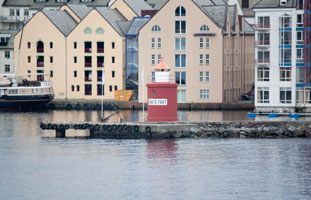
Located on the waterfront of Ålesund. Pretty much invisible in this photo is the fixed green light at the left end of the mole. It is listed separately in many indexes. (L 0761) [329500] ARLHS # NOR-289 |
|
| NO 893 |
Havstein
latitude 62° 29' 18.6" N longitude 6° 3' 47.4" E |
Breisundet og Ålesund Øyas north beach (L 0758) [328700] |
| NO 894 |
Alnes
latitude 62° 29' 23.4" N longitude 5° 58' 3" E
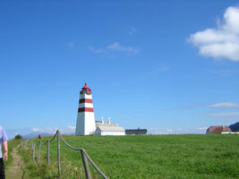
Readily accessible from Ålesund, this unusual and historic tower is one of Norway's most visited lighthouses. Automated in 1982, it is now managed by Giske Kommune. The station is operated as a cultural center and historic museum, with an exhibition hall and a café. Located at the northwestern point of Godøya. (L 0832) [338700] ARLHS # NOR-299
Photo courtesy Becky [webshots] |
|
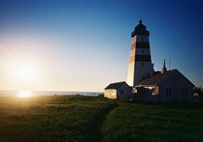
| NO 895 |
| Hogsteinen
latitude 62° 27' 47.4" N longitude 6° 1' 52.8" E
Built at the end of a stone mole, the light marks the southernmost point of the island of Godøya. The island is connected to Ålesund by a series of bridges and tunnels. (L 0756) [328500] ARLHS # NOR 121 |
| NO 896 |
Steinvåg
latitude 62° 27' 49.2" N longitude 6° 7' 22.2" E |
At Vikanesflu. (L 0765) [330000] |
| NO 898 |
Hellevik |
Located at Hellevik on the north side of the island of Lovsøya, which is 2.5 km northeast of Vigra. (L 0864) [344100] |
| NO 899 |
Innholmen |
West of Lepsøya (L 0860) [343500] |
| NO 900 |
Kveitskjer
latitude 62° 27' 7.2" N longitude 6° 10' 35.4" E |
Hessefjord (L 0768) [331000] |
| NO 901 |
Svinholmen
latitude 62° 26' 58.7" N longitude 6° 11' 22.2" E |
Inlet to Langevåg (L 0770) [331200] |
| NO 902 |
Fransholmen
latitude 62° 27' 1.8" N longitude 6° 14' 3" E |
Åsefjord (L 0774) [331400] |
| NO 903 |
Flisneset
latitude 62° 25' 6" N longitude 6° 23' 9.6" E |
Located on a point of land projecting into the Storfjord, about 3 km southeast of Vegsundet. photo (L 0576) [305700] |
| NO 904 |
Hjørungneset
latitude 62° 21' 13.2" N longitude 6° 6' 43.8" E |
Storfjorden near Sunnmørefjordene (L 0572) [305500] |
| NO 905 |
Flørauden
latitude 62° 25' 39" N longitude 5° 50' 4.8" E
October 5, 2010
Located on a small island about 4 km east of the Grasøyane lighthouse. (L 0710) [321500] |
|
| NO 906 |
| Grasøyane (Ulstein)
latitude 62° 25' 50.6" N longitude 5° 45' 32.6" E
October 5, 2010
Standing off the Hareidlandet peninsula, the light marks the beginning of the approaches to Ulstein to the south and Ålesund to the west. Located on a small island about 15 km northwest of Ulstein and 5 km off the northwestern coast of the Hareidlandet. (L 0712) [327600] |
| NO 907 |
Flø
latitude 62° 24' N longitude 5° 51' 3" E |
Hareidøy northwest side (L 0708) [321000] |
| NO 908 |
Langenes
latitude 62° 24' 22.7" N longitude 5° 39' 32" E |
Runde's northeast point |
| NO 909 |
Runde (Rundøy)
latitude 62° 24' 46.9" N longitude 5° 35' 9.5" E
The northernmost of a group of picturesque islands, Runde (Rundøy) is accessible from the mainland by a series of bridges. Located on the northwestern tip of the island, accessible by a hiking trail. (L 0722) [327000] ARLHS # NOR 306
Photo courtesy Ingvill K [Flickr] |
|
| NO 910 |
Rundesund (Saeviksten)
latitude 62° 22' 39.6" N longitude 5° 37' 41.4" E |
Located at the northern tip of the island of Remøya, beside the south end of the Rundebrua, the bridge from Remøya to Runde. photo (L 0726) [326200] ARLHS # NOR-412 |
| NO 911 |
Vattøy
latitude 62° 22' 24" N longitude 5° 47' 31.2" E
October 5, 2010
At Hamneskjær (L 0706) [320600] |
|
| NO 912 |
| Vattøyskjæret
latitude 62° 22' 3" N longitude 5° 46' 19.2" E
October 5, 2010
Vattøyas south side (L 0705) [320500] |
| NO 913 |
Boholmen
latitude 62° 20' 23.3" N longitude 5° 48' 32.2" E |
On a small peninsula just west of Osnes (L 0696) [315600] |
| NO 914 |
Torvikholmen
latitude 62° 20' 11.4" N longitude 5° 44' 40.2" E
October 5, 2010
Just off shore east of the village of Torvik. Our ferry had to make a hard left turn before this light to get into the dock. (L 0692) [315400] |
|
| NO 915 |
| Teigesund
latitude 62° 19' 25.2" N longitude 5° 45' 55.2" E
October 5, 2010
Dimnanes north west point (L 0688) [315200] |
| NO 916 |
Ulsteinvik Havn Vest |
Probably similar in appearance to the light below. (L 0703) [327400] |
| NO 917 |
Ulsteinvik Havn Øst (east)
latitude 62° 20' 29.1" N longitude 5° 50' 38.6" E
Located on a skerry marking the east side of the entrance to the harbor of Ulstein, a fairly large town on the west side of the island of Hareidlandet. Accessible only by boat. (L 0703.5)
Photo courtesy Public Domain photo [Wikipedia] |
|
| NO 918 |
Gallanes |
Located at the northeastern corner of Nerlandsøy, about 800 m north of Kvalsvik. (L 0730) [326000] ARLHS # NOR-399 |
| NO 919 |
Grønnholmen
latitude 62° 21' 29.4" N longitude 5° 36' 53.4" E |
Teigebogen (L 0740) [324200] |
| NO 920 |
Fosnavåg
latitude 62° 20' 40.2" N longitude 5° 38' 2.4" E |
Vågsøy north point (L 0747) [323200] |
| NO 921 |
Kyrkjeholmen
latitude 62° 19' 43.2" N longitude 5° 35' 31.8" E
October 5, 2010
Bergsøy west side [322000] |
|
| NO 922 |
| Flåvaer
latitude 62° 18' 55.6" N longitude 5° 34' 53.9" E
October 5, 2010
Located on a small island about 2 km south of Kvalsund. Accessible only by boat. (L 0674) [312500] |
| NO 923 |
Kvaleklubben (Klubben)
latitude 62° 18' 35.2" N longitude 5° 36' 35.1" E
October 5, 2010
Located on a skerry in the Herøyfjord about 1200 m west of the Flåvaer lighthouse. Accessible only by boat. (L 0676) [312800] |
|
| NO 924 |
Bakarskjær |
In Eiksund (L 0616) [319000] |
| NO 925 |
Aursnes
latitude 62° 14' 59.9" N longitude 5° 49' 30.4" E |
Aursnes south side (L 0612) [318600] |
| NO 926 |
Lille Hestholmflu |
East of St. Hestholm (L 0606) [318200] |
| NO 927 |
Dimna sørpynt
latitude 62° 17' 44.9" N longitude 5° 47' 26.7" E |
South of Dimna (as implied by the title of the light.) (L 0626) [316400] |
| NO 928 |
Bymannen
latitude 62° 17' 55.8" N longitude 5° 45' E |
East of Rafteset (L 0622) [316000] |
| NO 929 |
Røyresund
latitude 62° 19' 13.8" N longitude 5° 43' 12.7" E
October 5, 2010
Under the bridge (highway 654) south of Leinøy [314800] |
|
| NO 930 |
Steinsholmskjeret
latitude 62° 18' 15.3" N longitude 5° 39' 15" E |
Herøyfjorden (L 0684) [313000] |
| NO 931 |
Hidsneset |
Located on a rocky point near the northwestern corner of Gurskøy, about 5 km southwest of Kvalsund. Accessible only by boat in heavy seas. (L 0670) [312000] |
| NO 932 |
Svinøy
latitude 62° 19' 39.6" N longitude 5° 16' 3.6" E
This isolated lighthouse was automated in 2005, on the 100th anniversary of its establishment. Located on a small island in the Norwegian Sea about 20 km northwest of Larsnes. Accessible only by boat in heavy seas. (L 0650) [300000] ARLHS # NOR-042
Photo courtesy S/Y Runddans [Flickr] |
|
| NO 933 |
Sandshamn
latitude 62° 15' 40.8" N longitude 5° 33' 47" E |
Located at the harbor entrance in Ørsta, at the head of the Ørstafjord. (L 0668) [311200]
Photo courtesy Erling Sivertsen [Flickr] |
| NO 934 |
Gjerdesvika molo |
At moloen (L 0666) [311000] |
| NO 935 |
Langedrognes
latitude 62° 15' 60" N longitude 5° 28' 24.6" E
October 5, 2010
Sandsøy northeast side (L 0658) [309200] |
|
| NO 936 |
Saudeholmen
latitude 62° 11' 1.1" N longitude 5° 36' 17.6" E |
Rovdefjord (L 0548) [303000] |
| NO 937 |
Raudøy
latitude 62° 14' 28.2" N longitude 5° 58' 46.2" E |
Raudøyholmens north point (L 0568) [304600] |
| NO 938 |
Ørsta (Lianesholmen)
Located at the harbor entrance in Ørsta, at the head of the Ørstafjord. (L 0566) [304802]
Photo courtesy Erling Sivertsen [Flickr] |
|
| NO 939 |
Yksnøy
latitude 62° 13' 26.4" N longitude 5° 53' 27" E |
Off the south point of Voldafjord (L 0556) [303600] |
| NO 940 |
Furnes
latitude 62° 5' 40.2" N longitude 6° 8' 30.2" E |
Located on the north side of the Voldafjord about 5 km southeast of Volda. Apparently accessible only by boat. photo (L 0560) [304000] |
| NO 941 |
Årsetøy
latitude 62° 4' 36.6" N longitude 6° 15' 21" E |
Located on the north side of the Austefjord (an eastern extension of the Voldafjord) about 12 km southeast of Volda. photo (L 0562) [304200] |
| NO 942 |
Leitet |
Austfjorden near Sunnmørefjordene (L 0564) [304400] |
| NO 943 |
Syvdsfjorden
latitude 62° 7' 19.8" N longitude 5° 41' 35.4" E |
At Skåraneset (L 0552) [303200] |
| NO 944 |
Stabbane |
Åramsund (L 0544) [302400] |
| NO 945 |
Åramsund (Bleka)
latitude 62° 12' 10.2" N longitude 5° 29' 3" E |
Located on a skerry off the ferry terminal at Aram, ferries link this point to Larnes, on the other side of the Aramsund, and to the island of Voksa. (L 0542) [302200] |
| NO 946 |
Agnskjæret
latitude 62° 12' 2.4" N longitude 5° 21' 46.2" E |
Vanylvsgapet (L 0531) [300900] |
| NO 947 |
Terneskjeflu
latitude 62° 10' 44.4" N longitude 5° 24' 1.8" E |
Storesunds south side (L 0532) [301100] |
| NO 948 |
Haugsholmen
latitude 62° 10' 39.8" N longitude 5° 22' 11.2" E
Located at the western tip of Frekøy, an island in the Vanylvsfjord about 10 km west of Larsnes. Accessible only by boat. (L 0530) [301000] ARLHS # NOR-111
Photo courtesy Jens [Flickr] |
|
| NO 949 |
Fiskåholmen
latitude 62° 5' 42" N longitude 5° 32' 47.4" E |
Syltefjord, South point of Holmens (L 0538) [301600] |
| NO 950 |
Syltefjord (Strand)
latitude 62° 4' 54" N longitude 5° 36' 11.4" E
Located at Sylte, on the north side of the Syltefjord about 2.5 km east of Fiskåbygd. Readily accessible from highway 61, which follows the fjord. (L 0540) [301800]
Photo courtesy YIP2 [Flickr] |
|
| NO 951 |
Åheim
latitude 62° 2' 50.5" N longitude 5° 31' 4" E |
At Torvholmen (L 0536) [301500] |
|
|
 Northwest Norway
