|
The lights of Turkey bordering on the Black Sea. Lights are numbered West to East. You can almost always click on the light to go to it's specific (larger resolution) copy. Each lighthouse is linked to (in our editorial opinion) the best reference site for that light. I would like to include directions on how to get to these lights. If you know such data, could you eMail me and I'll post it here (with your choice of attribution.) mailme |
|
| TR 121 |
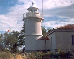
Patara
latitude 44° 16' 36" N longitude 15° 17' 34.7" E |
Ruins of a Roman lighthouse built during the reign of Nero (54-68 AD). The surviving portion of the tower stands about 17 ft high. It was unearthed about 2005 by archaeologists studying the Roman port of Patara, an ancient Greek city annexed to the Empire in 43 AD. The ancient harbor eventually filled in completely and became a swamp; the lighthouse was apparently excavated from this sediment. The site is near the village of Gelemis, about 10 km west of Kalkan in westernmost Antalya province.
|
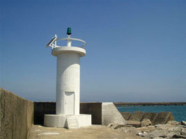
| TR 122 |
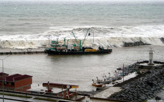
Iğneada East Breakwater
latitude 41° 53' 12.1" N longitude 28° 1' 14.5" E |
Located at the end of the east (main) breakwater of Iğneada.
photo |
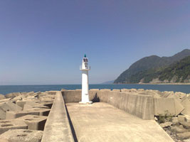
| TR 123 |
Iğneada West Breakwater
latitude 41° 53' 17" N longitude 28° 1' 21.5" E |
Located at the end of the west breakwater of Iğneada.
photo |
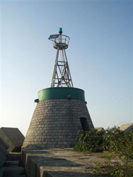
| TR 124 |
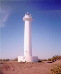
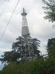
Iğneada Burnu
latitude 41° 53' 5.2" N longitude 28° 3' 22.4" E
The original lighthouse was destroyed in 1903 and replaced by a temporary light. Located near Limanköy at the tip of the cape, which projects into the Black Sea about 8 km south of the Bulgarian border.
Photo courtesy Izzet Kirbas [Panoramio] |
|
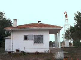
| TR 125 |
Koru (Igneada) |
ARLHS # TUR-040 |
| TR 126 |
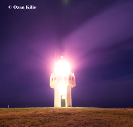
Karaburun (Black Sea)
latitude 41° 20' 51.1" N longitude 28° 41' 0.8" E
The original lighthouse was much higher, with a focal plane of 302 ft; we don't know if that lighthouse survives. Located on a short, sharp promontory at Karaburun, about 40 km northwest of Istanbul.
ARLHS # TUR-036
Photo courtesy Ozan Kilic [Flickr] |
|
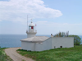
| TR 127 |
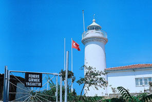
| Rumeli (Türkeli Feneri)
latitude 41° 14' 3.4" N longitude 29° 6' 43.7" E
This is Turkey's tallest lighthouse. Rumeli (or Rumelia) is an old name for the Turkish possessions in Europe, and this lighthouse stands on the west side of the entrance to the Bosporus from the Black Sea. During early phases of construction, the French builders discovered that the chosen site is on top of an ancient mausoleum. They revised their plans to allow access to the mausoleum, which remains open today. Located on a hillside above the village of Rumelifeneri.
(E 4956) ARLHS # TUR-053
Photo courtesy Captain Peter Mosselberger [ListOfLights] |
| TR 128 |
Rumeli Burnu |
ARLHS # TUR-060 |
| TR 129 |
Anadolu Feneri
latitude 41° 13' 2.3" N longitude 29° 9' 7.6" E
Anadolu is the Turkish name for Anatolia, and the lighthouse stands on the east (Anatolian) side of the entrance to the Bosporus from the Black Sea. Located on a high promontory above the village of Anadolufeneri.
ARLHS # TUR-014
Photo courtesy Alara Orhon [Flickr] |
|
| TR 130 |
| Sile
Built by French engineers under contract to the Ottoman Empire, the lighthouse is one of Turkey's best known and most beautiful. Located on the point of the cape about 1 km northeast of the town of Şile.
ARLHS # TUR-046
Photo courtesy Kelty McKinnon [Flickr] |
| TR 131 |
Kefkenada (Kefken Island)
latitude 41° 12' 58.2" N longitude 30° 15' 29" E |
One of the few islands on Turkey-s Black Sea coast, Kefken is located off Kefken Burnu, a prominent cape about 50 km east of Şile. Boat transportation to the island is available. Located near the west end of the island, overlooking the island's harbor
photo ARLHS # TUR-058 |
| TR 132 |
Ölüce
latitude 41° 18' 48.8" N longitude 31° 23' 57.2" E
Located on Mount Kestaneci, a prominent cape about 3 km north of Ereğli.
ARLHS # TUR-044
Photo courtesy Coastal Safety Commission [Kiyi Emniyeti] |
|
| TR 133 |
Ereğli Outer Breakwater
latitude 41° 16' 23.8" N longitude 31° 24' 11.8" E |
Located at the end of the new south outer breakwater of Ereğli.
|
| TR 134 |
Eregli/Liman BR. |
ARLHS # TUR-020 |
|
|
| TR 137 |
| Zonguldak
latitude 41° 27' 52.5" N longitude 31° 47' 15.4" E
The light station is adjacent to a city park. Located on a high promontory at the northeast entrance to Zonguldak harbor.
ARLHS # TUR-057
Photo courtesy lokman önsoy [Flickr] |
| TR 140 |
| Demirli Burnu
latitude 41° 40' 49.3" N longitude 32° 13' 31.4" E
Located on a promontory on the south side of Bartin harbor, 12 km northwest of the city.
Photo courtesy Coastal Safety Commission [Kiyi Emniyeti] |
| TR 141 |
Amasra
latitude 41° 45' 10.5" N longitude 32° 22' 59.1" E
Amasra is a small port about 15 km northeast of the city of Bartin. This light is a sibling of the Sinop lighthouse. Located atop a cliff on the north side of a steep-sided island northwest of Amasra harbor.
Photo courtesy Nosferatü [wikipedia] |
|
| TR 142 |
| Amasra South Breakwater
latitude 41° 44' 43" N longitude 32° 23' 44.2" E
Located at the end of the south (really the east) breakwater.
Photo courtesy Dominic Marra [Flickr] |
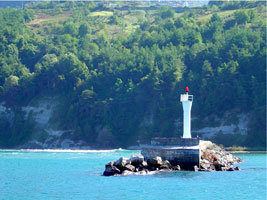
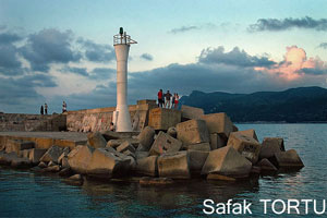
| TR 143 |
Amasra North Breakwater
latitude 41° 44' 51.1" N longitude 32° 23' 53" E
Located at the end of the north breakwater.
Photo courtesy Safak TORTU [Flickr] |
|
| TR 144 |
Kurucaşile |
Located on a promontory just west of the harbor of Kurucaşile.
|
| TR 145 |
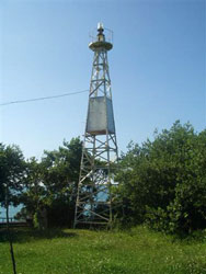
Kerempe
latitude 42° 37.7" N longitude 33° 19' 56.6" E |
This lighthouse is on a mountainous cape, at the top of a cliff about 800 m from the shore. Located about 8 km west of Doğanyurt. It is however accessible by road.
photo ARLHS # TUR-007 |
| TR 146 |
Inebolu
latitude 41° 58' 46" N longitude 33° 45' 49.9" E
Located on a promontory overlooking the harbor of Inebolu.
Photo courtesy Coastal Safety Commission [Kiyi Emniyeti] |
|
| TR 147 |
| Inebolu North Breakwater
latitude 41° 58' 50.7" N longitude 33° 46' 24.5" E
Located at the end of the north (outer) breakwater of Inebolu.
Photo courtesy Coastal Safety Commission [Kiyi Emniyeti] |
| TR 148 |
Usta Burnu (Ayancik)
latitude 41° 58' 34.1" N longitude 34° 29' 22.9" E |
Located on a prominent cape at Çaylıoğlu, about 8 km west of Ayancik.
|
| TR 149 |
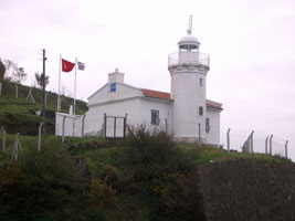
Ince Burnu (Black Sea) (Sinop)
This lighthouse stands on the northernmost point of Turkey. Note: Turkey has several other Ince Buruns. Located on the point of the cape, about 25 km west northwest of Sinop.
ARLHS # TUR-005
Photo courtesy Kerim Arli [Flickr] |
|
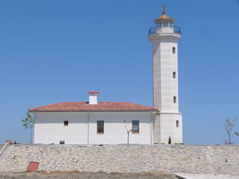
| TR 150 |
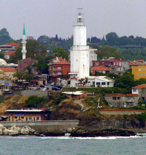
| Sinop (Boztepe Burnu)
latitude 42° 1' 9.8" N longitude 35° 12' 29.3" E
This might be the original lighthouse covered by stucco. Boztepe Burnu is a promontory, shaped rather like a turkey's head, that protects the harbor of Sinop, one of the oldest ports of Turkey's Black Sea coast. Located at the tip of the promontory.
Photo courtesy Coastal Safety Commission [Kiyi Emniyeti] |
| TR 151 |
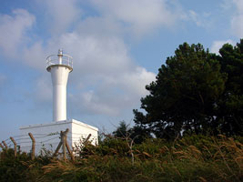
Gerze (Kosk Burnu)
latitude 41° 47' 59.3" N longitude 35° 10' 23.3" E |
Located on a sharp promontory that shelters the harbor of Gerze, about 25 km south of Sinop
photo |
|
|
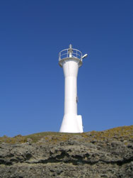
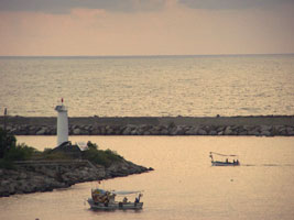
| TR 152 |
Gerze North Mole
latitude 41° 47' 53.6" N longitude 35° 12' 13.7" E |
Located at the end of the north breakwater mole of Gerze.
photo |
| TR 153 |
Bafra Burnu
latitude 41° 43' 48.8" N longitude 35° 56' 46.7" E |
Bafra Burnu is the cape formed by the delta of the Kizilirmak (Irmak or Halys River). Turkey's longest river, the Kizilirmak drains a large part of central Anatolia. Located about 1 km southwest of the river's mouth near Sahilkent, about 20 km north of Bafra.
photo |
| TR 154 |
Plaj Feneri (Samsun)
latitude 41° 18' 52.3" N longitude 36° 20' 18.3" E
The lighthouse is part of an extensive beach redevelopment project being undertaken by the city of Samsun. The lighthouse resembles the original lighthouse. That lighthouse disappeared sometime in the 1930s or 1940s. Located near the base of the Samsun North Mole.
Photo courtesy Muammer Ay [panoramio] |
|
| TR 155 |
| Samsun East Mole
latitude 41° 18' 28.3" N longitude 36° 21' 3.1" E
Located at the end of the east mole of Samsun harbor.
Photo courtesy Faik Alkan Tetic |
| TR 157 |
Çiva Burnu
latitude 41° 22' 2.6" N longitude 36° 40' 42" E
Çiva Burnu (Cape Civa or Cape Mercury) is the wedge-shaped delta of the Yeşilirmak (Iris) River. Presently the river flows into the sea at the point of the cape. The lighthouse is 2.5 km southeast of the river mouth and about 30 km northeast of the city of Samsun.
ARLHS # TUR-002
Photo courtesy Coastal Safety Commission [Kiyi Emniyeti] |
|
| TR 158 |
| Çalti Burnu
latitude 41° 15' 45.4" N longitude 37° 1' 10.5" E
Located on a cape about 7 km northeast of Terme.
Photo courtesy Coastal Safety Commission [Kiyi Emniyeti] |
| TR 159 |
Ünye
latitude 41° 8' 39.7" N longitude 37° 17' 32.1" E
Located on a promontory sheletering the harbor of Ünye.
Photo courtesy yasin aydın [panoramio] |
|
| TR 161 |
Yasun Burnu Deniz Feneri
latitude 41° 8' 9.9" N longitude 37° 40' 55.9" E
Located at the tip of a very sharp promontory about 8 km west of Çam Burnu.
Photo courtesy Zafer Üstün [Panoramio] |
|
| TR 161C |
Vonakasabann (old)
latitude 41° 6' 57" N longitude 37° 47' 9.9" E |
Çam Burnu (Pine Point) is a common geographical name in Turkey. Located on a prominent cape 5 km north of Perşembe and 25 km northwest of Ordu.
photo ARLHS # TUR-067 |
| TR 162 |
Ordu (Piramet)
latitude 41° 1' 11.4" N longitude 37° 51' 23.2" E |
Located at the end of the north (outer) breakwater at Kumbaşi, about 4 km northwest of Ordu.
photo |
| TR 163 |
Giresun
latitude 40° 55' 18.2" N longitude 38° 23' 21.3" E
Located on a steep hillside overlooking the base of the breakwater of Giresun.
ARLHS # TUR-070
Photo courtesy Coastal Safety Commission [Kiyi Emniyeti] |
|
| TR 164 |
Çamburnu (Zefre) (Hisarustu-Giresun) |
ARLHS # TUR-068 |
| TR 165 |
Eynesil (Eynesil-Giresun)
latitude 41° 4' 43.3" N longitude 39° 9' 48.8" E |
Located on a prominent cape about 3 km northeast of the town of Eynesil, built within the walls of the fortress.
photo ARLHS # TUR-069 |
| TR 166 |
Yoroz Burnu Fenerý (Trabzon)
latitude 41° 6' 23.9" N longitude 39° 25' 8.2" E
Located on Yoroz Burnu (Cape Yoroz), a very prominent headland about 13 km northeast of Vakfikevir and about 35 km west of the city of Trabzon.
ARLHS # TUR-010
Photo courtesy Alper Gürdal [Panoramio] |
|
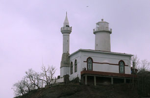
| TR 167 |
Trabzon Güzelhisar
latitude 41° 30" N longitude 39° 44' 5.8" E |
The light stands in front of the historic citadel (güzelhisar) of Trabzond. Located on a promontory a short distance west of Trabzond harbor.
photo
The original lighthouse was a short masonry tower attached to a keeper's house, very similar to the surviving Sinop lighthouse (see photo above). TR150 |
| TR 168 |
Arakli Burnu
latitude 40° 57' 24" N longitude 40° 2' 32.6" E
Located on a prominent cape about 3 km northwest of Arakli. This is just off the coastal highway.
Photo courtesy Coastal Safety Commission [Kiyi Emniyeti] |
|
| TR 169N |
Arakli North Breakwater
latitude 40° 56' 43.7" N longitude 40° 3' 20.5" E |
Located at the end of the north (outer) breakwater at Arakli. This pier may not be walkable.
photo |
| TR 169 |
Arakli South Breakwater
latitude 40° 56' 42.4" N longitude 40° 3' 13.6" E
Located at the end of the south (inner) breakwater at Arakli.
Photo courtesy M.Yilmaz [panoramio] |
|
| TR 170 |
| Pazar South Breakwater
latitude 41° 10' 55.4" N longitude 40° 52' 45.6" E
Located at the end of the south (inner) breakwater at Pazar.
Photo courtesy Coskun Oguz Namli [panoramio] |
| TR 171 |
Pazar North Breakwater
latitude 41° 10' 59.9" N longitude 40° 52' 49.4" E
Located at the end of the north (outer) breakwater at Pazar.
Photo courtesy Coskun Oguz Namli [panoramio] |

|
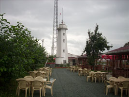
| TR 172 |
Rize (Piryos Burnu) |
Located on a bluff overlooking the harbor of Rize. Since the tower is close to the coastal road it should be easy to spot.
|
| TR 173 |
Hopa (Çamh Burnu)
latitude 41° 22' 39.3" N longitude 41° 22' 7.5" E
Located beside the coastal highway, on a headland about 4 km northeast of Arhavi and 12 km southwest of the town of Hopa. ARLHS # TUR-016
Photo courtesy tutasteperde [Panoramio] |
|
| TR 174 |
Hopa-Sarp (Sarp Range Front)
latitude 41° 22' 39.3" N longitude 41° 22' 7.5" E |
These range lights were built following an agreement between Turkey and the Soviet Union establishing the boundary between the two countries- 12-mile territorial waters; the range line lies along this sea boundary. Sarp is a town on the border. Located just south of the Georgian border near the waterfront.
photo
The rear light is just on the Georgian side of the border and is listed under Georgia. GE1 ARLHS # TUR-071 |
| TR 176 |
| Hopa Inner Breakwater
latitude 41° 24' 55" N longitude 41° 25' 49" E
Located at the end of the inner (east) breakwater of Hopa, Turkey's easternmost Black Sea port.
Photo courtesy Xopuri08 [p] |
| TR 177 |
Delik Adasi |
ARLHS # TUR-018 |
| TR 178 |
Ilyasdagi |
ARLHS # TUR-004 |
|
|
 Bulgaria