|
The lights of Bulgaria are all located on the Black Sea and cover much of the west edge of that Sea. Lights are numbered from the South to the North. |
|
| BG 1 |
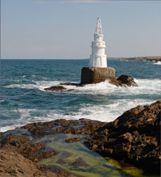
Akhtopol
latitude 42° 6' 2.3" N longitude 27° 56' 57" E
Located on a rock just off the coast at Ahtopol, about 12 km southeast of Tsarevo. It appears that the lighthouse can be approached at low water. ARLHS # BUL-001
Photo courtesy s vatev [Flickr] |
|
| BG 2 |
Michurin Breakwater (Tazarevo Breakwater Head) |
ARLHS # BUL-011 |
| BG 3 |
Michurin Main (Tazarevo Main) |
A likely location is atop the new Bay View condominium building, which is on the promontory on the north side of Tsarevo harbor. ARLHS # BUL-012 |
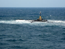
| BG 4 |
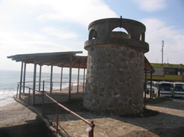
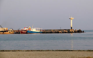
Michurin On The Rock (Tzarevo On The Rock)
latitude 42° 10' 0.8" N longitude 27° 52' 5" E
Located on a rock off the harbor of Tsarevo. Accessible only by boat. ARLHS # BUL-031
Photo courtesy Mihaela Ivanova [panoramio] |
|
| BG 5 |
Kiten Pier Head |
ARLHS # BUL-009 |
| BG 6 |
Primorsko Pier
latitude 42° 15' 48.2" N longitude 27° 45' 32.8" E
Located at the end of the breakwater pier in Primorsko. Accessible by walking the pier (caution: no railings). ARLHS # BUL-019
Photo courtesy mayanedeva [webshots] |
|
| BG 7 |
| Maslen Nos (Cape Zeitin (Black Sea))
latitude 42° 18' 25" N longitude 27° 47' 33.1" E
Located on a rocky promontory about 7 km northeast of Primorsko. ARLHS # BUL-010
Photo courtesy Svilen Sirmanov [panoramio] |
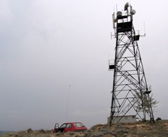
| BG 8 |
Nos Balchik ARLHS # BUL-029
Photo courtesy Christo Ignatov [panoramio] |
|
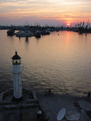
| BG 9 |
Sozopol |
Located at an elbow of the North Pier at Sozopol. ARLHS # BUL-034 |
| BG 10 |
Sozopol West (Agios Petros South Pier ) |
Located at the end of the west quay at Sozopol harbor. photo ARLHS # BUL-036 |
| BG 11 |
Sozopol East (Agios Petros North Pier)
latitude 42° 25' 17.4" N longitude 27° 41' 7.3" E |
The pier is connected to a peninsula that was formerly the site of a naval college but is now designated as the site of a hotel. Located at the end of the north (breakwater) mole protecting the harbor at Sozopol. photo ARLHS # BUL-035 |
| BG 12 |
Chu Kalya (Sukala Point) |
ARLHS # BUL-020 |
|
|
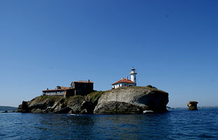
| BG 13 |
Sveta Anastasiya (Ostrov Bolshevik)
latitude 42° 28' 5.8" N longitude 27° 33' 10.7" E
This lighthouse appears to be a sibling of the Sv. Ivan Light. Sveta Anasastiya is a small island in Burgas Bay about 6 km east southeast of the Burgas waterfront. It is accessible by passenger ferry from Burgas. ARLHS # BUL-021
Photo courtesy Christo Ignatov [eMail] |
|
| BG 14 |
Sveti Ivan (Megalo Nisi) |
ARLHS # BUL-022 |
| BG 15 |
Burgas North Head Of Jetty |
ARLHS # BUL-028 |
| BG 16 |
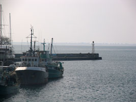
Burgas East Breakwater Head
latitude 42° 28' 53.1" N longitude 27° 29' 0.4" E
This lighthouse appears to be a prefabricated French cast iron tourelle. Located at the end of a breakwater mole on the north side of the entrance to Burgas harbor. There is a road on the mole. ARLHS # BUL-002
Photo courtesy Paul [panoramio] |
|
| BG 17 |
Burgas South Head Of Jetty |
ARLHS # BUL-003 |
| BG 18 |
Burgas West Breakwater |
ARLHS # BUL-041 |
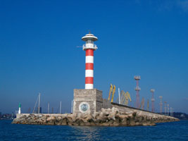
| BG 19 |
Burgas East Breakwater West Arm (Black Sea)
latitude 42° 29' 0.7" N longitude 27° 28' 55.9" E |
Located at the end of the inner breakwater on the east side of the entrance to the inner harbor of Burgas. photo ARLHS # BUL-026 |
| BG 20 |
Burgas West Breakwater East Arm
latitude 42° 29' 0.7" N longitude 27° 28' 46.2" E |
Located at the end of the inner breakwater on the west side of the entrance to the inner harbor of Burgas. photo ARLHS # BUL-027 |
| BG 21 |
Pomorie Reef
latitude 42° 33' 2.4" N longitude 27° 39' 41.8" E
Pomorie is a beach town at the end of a narrow spit about 15 km east northeast of Burgas; the light marks the north side of the entrance to Burgas Bay. Located on a rock southeast of the beach at Pomorie. ARLHS # BUL-018
Photo courtesy Bartek Dušan [panoramio] |
|
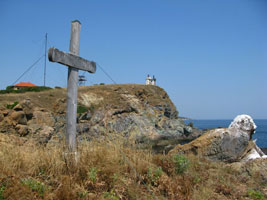
| BG 22 |
| Nesebur (Old)
latitude 42° 39' 40.7" N longitude 27° 44' 16.4" E
Nesebar is a beach resort town about 25 km northeast of Burgas. The lighthouse is on an island just offshore and connected to the town by a causeway. Located on the northern tip of the island. ARLHS # BUL-033
Photo courtesy Christo Ignatov [eMail] |
|
|
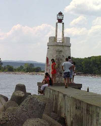
| BG 23 |
Nesebur
The active light is at the end of a breakwater attached to the southwestern tip of the island. ARLHS # BUL-013
Photo courtesy Christo Ignatov [eMail] |
|
| BG 24 |
| Nos Emine (Cape Emine (Burgas Bay))
latitude 42° 42' 5.1" N longitude 27° 53' 59.8" E
Cape Emine is a prominent cape projecting into the Black Sea about 20 km northeast of Nessebur. ARLHS # BUL-014
Photo courtesy Evgeni Dine [wikipedia] |
| BG 25 |
Cape Sveti Atanas |
ARLHS # BUL-004 |
| BG 26 |
Sveti Atanas (Nos Sveti Atanas, Byala)
latitude 42° 51' 16.4" N longitude 27° 54' 7.3" E |
Located on a hillside above a promontory at Byala (Bjala). photo ARLHS # BUL-039 |
| BG 27 |
Kamchiya
latitude 43° 1' 26" N longitude 27° 53' 15.1" E |
Located in a small hilltop village on the north side of the mouth of the Kamchiya River about 5 km southeast of Bliznatsi. ARLHS # BUL-007 |
| BG 28 |
Cape Galata (1863)
It appears that this light is at the far left of the photo below. ARLHS # BUL-038 |
|
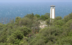
| BG 29 |
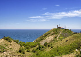
| Cape Galata (1913)
latitude 43° 10' 15.2" N longitude 27° 56' 43.7" E
The light station was damaged by shelling from the Russian cruiser Empress Maria in 1915, during World War I, but it was repaired after the war. Nos Galata is a prominent cape at the south side of the entrance to Varna Bay. ARLHS # BUL-030
Photo courtesy Svilen Enev [wikipedia] |
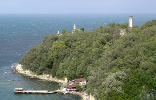
| BG 30 |
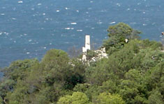
Cape Galata (1987)
latitude 43° 10' 12.4" N longitude 27° 56' 42" E
Nos Galata is a prominent cape at the south side of the entrance to Varna Bay, about 5 km southeast of the city, and this light serves as the city's landfall light. You can see this light at the right of the photo above. photo ARLHS # BUL-015 |
|
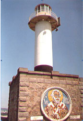
| BG 31 |
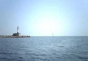
| Varna East Breakwater (Varnenski, St. Nicholas)
latitude 43° 11' 14.1" N longitude 27° 55' 19" E
This lighthouse is a replica of the original, which was moved to a museum setting. Located at the end of the main breakwater of Varna harbor. ARLHS # BUL-025
Photo courtesy Ivan D [Flickr] |
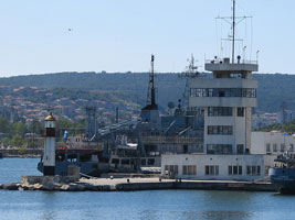
| BG 32 |
Varna South Pier
latitude 43° 11' 28.3" N longitude 27° 55' 5.4" E
This lighthouse is a typical prefabricated French tourelle. Located at the end of a short pier on the west (mainland) side of Varna's inner harbor. ARLHS # BUL-024
Photo courtesy Dmitry Rostopshin [lightphotos] |
|
| BG 33 |
| Varna East Breakwater Spur
latitude 43° 11' 28.4" N longitude 27° 55' 14.8" E
This lighthouse is a typical prefabricated French tourelle, identical to the South Breakwater Light. Located on a short westward spur off the east (main) breakwater at Varna, marking (with the South Breakwater Light) the entrance to Varna's inner harbor. ARLHS # BUL-023
Photo courtesy Dmitry Rostopshin [lightphotos] |
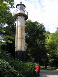
| BG 34 |
Varnensko Ezero |
ARLHS # BUL-040 |
| BG 35 |
Georgi Dimitrov (Varna Museum) ARLHS # BUL-032
Photo courtesy Christo Ignatov [panoramio] |
|
| BG 36 |
| Varna Outer Breakwater ARLHS # BUL-037
Photo courtesy Christo Ignatov [eMail] |
| BG 37 |
Evxinograd Pierhead (Yevksinogradskiy)
latitude 43° 13' 0.2" N longitude 27° 59' 13.7" E
Located on the north side of Varna Bay about 5 km east northeast of the city's harbor. photo ARLHS # BUL-006
Photo courtesy Christo Ignatov [panoramio] |
|
| BG 38 |
Ekrene |
Located on a bluff about 20 km northeast of Varna. photo ARLHS # BUL-005 |
| BG 39 |
Kavarna Pierhead
latitude 43° 24' 40.6" N longitude 28° 21' 21.6" E
Located at the end of the east pier at Kavarna.
Photo courtesy Christo Ignatov [panoramio] |
|
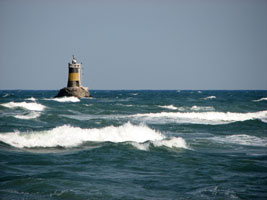
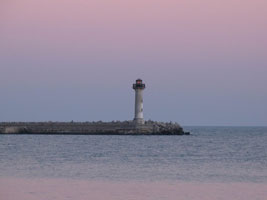
| BG 40 |
Nos Kaliakra (Cape Kaliakra (Black Sea))
latitude 43° 21' 43.4" N longitude 28° 27' 55.8" E |
The cape is a popular tourist attraction, but there is a curious lack of photos of the lighthouse. Located about 20 km south of Shabla and 12 km southeast of Kavarna. photo ARLHS # BUL-016 |
| BG 41 |
Kamen Bryag
latitude 43° 27' 42.1" N longitude 28° 33' 42.2" E
Located about 20 km south of Shabla and 12 km southeast of Kavarna. ARLHS # BUL-008
Photo courtesy Svilen Sotirov [panoramio] |
|
| BG 42 |
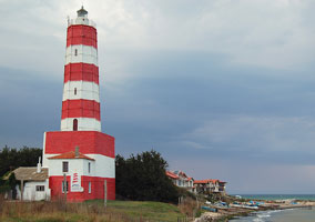
| Shabla
latitude 43° 32' 25.3" N longitude 28° 36' 25.1" E
This is Bulgaria's oldest, tallest, and best known lighthouse. Built by the Ottoman Empire, it stands on the easternmost point of the country. Located about 5 km east of the town of Shabla in the northeastern corner of Bulgaria. ARLHS # BUL-017
Photo courtesy Manatari [Flickr] |
| BG 43 |
Krapets (Kartolia) |
A twin of the Kamen Bryag lighthouse. Located on a promontory on the north side of Krapets, about 10 km south of the Romanian border. photo |
|
|

 Russia

