|
This page shows the lighthouses in the Republic of Georgia (known by the locals as Sakartvelo. I've kept the internationally recognized name for now.) Some of this territory is arguably independent, but not universally recognized, so was included in this index. Lights are numbered from South to the North. |
|
| GE 1 |
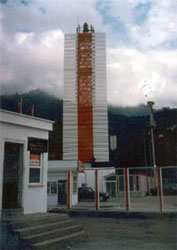
Sarp Range Rear (Hopa-Sarp)
latitude 41° 31' 30.7" N longitude 41° 33' 21.8" E
These range lights were built following an agreement between Turkey and the Soviet Union establishing the boundary between the two countries- 12-mile territorial waters; the range line lies along this sea boundary, which is not on exactly the same line as the land boundary. The front light is built just on the Turkish side of the border and is listed under Northern Turkey. Sarp is a town on the border. Located just north of the Turkish border and about 300 m inland. TR 174
Photo courtesy Coastal Safety Commission [Kiri Emniyetie] |
|
| GE 2 |
| Batumi Approach Range Rear
latitude 41° 38' 48.8" N longitude 41° 39' 6" E
Located across the harbor basin from the front light. It is assumed the light is the tower next to the palm tree as the brown tower in the middle is clearly lights for the harbor area.
Photo courtesy Stefan Riedel [Panoramio] |
| GE 3 |
Batumi Approach Range Front
latitude 41° 38' 59.7" N longitude 41° 39' 0.7" E
Located about 150 m east of the Petroleum Harbor lighthouse on the main pier at Batumi.
Photo courtesy Odin Palme [Panoramio] |
|
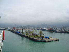
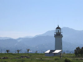
| GE 4 |
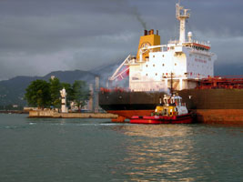
| Bukhta Batumiyskaya (Batumi Harbour)
latitude 41° 38' 58.3" N longitude 41° 38' 55" E
The harbor of Batumi has been an important oil terminal since 1883, with oil arriving here by pipeline from Baku, Azerbaijan. The rear light is on a small structure 1.3 km to the south. Located at the western end of the main pier at Batumi. ARLHS # GEO-001
Photo courtesy Jeremy Teigen [Flickr] |
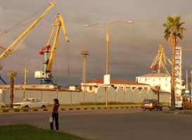
| GE 5 |
Batumi Entrance (Range Front?)
latitude 41° 39' 9.9" N longitude 41° 38' 38.7" E |
Located on the west side of the harbor entrance. The rear light is said to be 260 m west on a similar tower, but it cannot be seen in Google satellite images. photo |
| GE 6 |
Kobuleti |
Located about 25 km north of Batumi. |
|
|
| GE 6B |
Batumi (Batum, Mys Burun Tabiya)
latitude 41° 39' 20.7" N longitude 41° 38' 28.4" E
Russia built a lighthouse here in 1883, replacing a smaller Turkish light. Located on the point of Mys (Cape) Burun Tabiya, which partly shelters the harbor of Batumi, about 1 km northwest of the harbor light.
Photo courtesy Gilad Rom [Flickr] |
|
| GE 7 |
Souksu (Bambora) |
This light marks Mys (Cape) Souksu, about 3 km west of Gudauta. This is also a beach resort area. |
| GE 8 |
Poti Rear Range
latitude 42° 7' 59.7" N longitude 41° 39' 40" E
Built by British engineers for the Russian empire, this is one of the oldest lighthouses of the eastern Black Sea. Ships approach Poti harbor from the north, parallel to the coast, so the lighthouse is located 1930 m south southeast of the front light, close to the beach and beside one of the branches of the Rioni River delta. ARLHS # GEO-004
Photo courtesy Jano Zhvania [Flickr] |
|
| GE 9 |
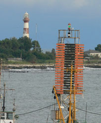
| Poti Inner Range Front
latitude 42° 8' 57.9" N longitude 41° 39' 10" E
Located on the south mole of Poti harbor.
Photo courtesy Dosyu Donchev [Panoramio] |
|
|
| GE 10 |
Kulevi (Redut-Kale)
latitude 42° 16' 4" N longitude 41° 38' 19.5" E |
Kulevi is the site of a new oil terminal. Located about 1 km south of the terminal-s entrance and about 12 km north of Poti. |
| GE 11 |
Mys Kodori |
Located on a headland near Gulripsh, about 20 km southeast of Sukhumi. |
Abkhazia
Abkhazia is an independent country under Russian support.
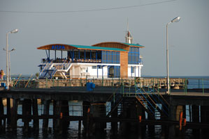
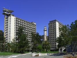
| GE 12 |
Sukhumi Passenger Pier Range Front
latitude 42° 59' 44.1" N longitude 41° 1' 24" E
The building appears to include a restaurant. Located at the end of the middle pier in downtown Sukhumi.
Photo courtesy user Vosk [Panoramio] |
|
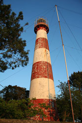
| GE 14 |
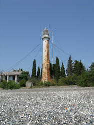
| Sukhumi (Mys Suchumskij)
latitude 42° 58' 54.6" N longitude 40° 58' 18.4" E
This lighthouse was prefeabricated in France by the firm of Ernest Couin. The Russian article says the lighthouse has resumed operation, apparently with a small light mounted in front of the historic lantern. Located on the point of Mys (Cape) Sukhumi, about 4 km southwest of the center of the city. ARLHS # GEO-003
Photo courtesy wikipedia [wikipedia] |
| GE 15 |
Psyrtskha (Novy Afon) |
Novy Afon (New Athos) is a historic Orthodox monastery, now a branch of the Abkhazian state museum. Located in Psyrtskha, about 22 km west of Sukhumi. |
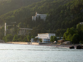
| GE 17 |
Pitsunda (1902) (Mys Pitsunda)
latitude 43° 8' 51.2" N longitude 40° 20' 32.5" E
Located on the point of Mys (Cape) Pitsunda. The photo shows both the old and the new lights. ARLHS # GEO-002
Photo courtesy Евгений Перцев [Panoramio] |
|
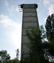
| GE 18 |
Pitsunda (new) |
Located on the west side (on the left above) of the historic lighthouse. photo |
| GE 20 |
Gagrinskiy
The building appears to be a resort hotel; Gagra has been a resort town since the 1880s. Located about 25 km east of the Russian border.
Photo courtesy maxell81 [Panoramio] |
|
| GE 23 |
| Gyachripsh (Leselidze)
latitude 43° 23' 12.1" N longitude 40° 1' 27.6" E
Gyachripsh is a resort town just east of the Russian border. The town was renamed Leselidze in 1944 in honor of a Soviet general; it resumed its historic name in 1992.
Photo courtesy mechanist [panoramio] |
|
|

 Russia
