|
Greece's continental boundaries are shaped like an inverted "U". This page covers those lights in the Aegean sea which is the inside of the "U". You can almost always click on the light to go to it's specific (larger resolution) copy. Each lighthouse is linked to (in our editorial opinion) the best reference site for that light. I would like to include directions on how to get to these lights. If you know such data, could you eMail me and I'll post it here (with your choice of attribution.) mailme |
|
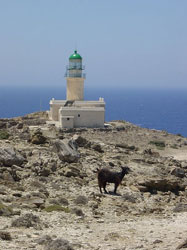
| GR 91 |
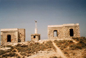
Prasonísi
Located on a peninsula (prasonísi) projecting from the southern tip of Ródos (Rhodes). This is known as an excellent wind-surfing location.
Photo courtesy Alan & Marinka [Flickr] |
|
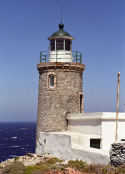
| GR 92 |
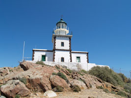
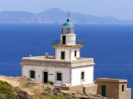
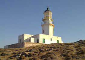
| Akrotíri (Thira Island)
latitude 36° 21' 29.4" N longitude 25° 21' 24.9" E
Nicely refurbished, this is one of the best known and most visited lighthouses of the Aegean. Located on Ákra Akrotíri, the southern tip of Santoríni. ARLHS # GRE-039
Photo courtesy JenniKate Wallace [Flickr] |
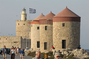
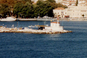
| GR 93 |
Ágios Nikólaos (Rhodes)
latitude 36° 27' 4.1" N longitude 28° 13' 40.7" E
The fort is one of the fortifications built by the Knights Hospitaller, crusaders who ruled the island from 1309 until it was captured by the Ottoman Turks in 1522-23. Located at the end of the main breakwater on the east side of the harbor of Ródos (Rhodes), at the northern tip of the island.
Photo courtesy Yehuda Cohen [Flickr] |
|
| GR 94 |
Aspró unta (Folégandros Island)
latitude 36° 37' 58.5" N longitude 24° 51' 42.9" E |
Located on the southwest coast of the Folégandros about 3 km west of Áno Meriá. Accessible by road. photo ARLHS # GRE-044 |
| GR 95 |
Íos (Ákra Fanari)
latitude 36° 43' 2.9" N longitude 25° 15' 31.3" E |
Íos has a beautiful natural harbor. Savas writes that "in the island of Íos the lighthouse was restored and remains open to the public with the initiative of the local authorities." However, tourist sites for Íos do not mention the lighthouse as an attraction. Located on Ákra Fanari, on the west side of the Íos harbor entrance photo |
| GR 96 |
Ormos Milou (Mílos Harbor)
latitude 36° 43' 16.8" N longitude 24° 26' 12.8" E |
Located atop a promontory sheltering the north side of the harbor of Mílos. photo |
| GR 97 |
Políagos (Kimolos Island)
latitude 36° 45' 13.8" N longitude 24° 39' 52.9" E |
This lighthouse stands at the western edge of a 16 km wide passage between the Mílos group and Folégandros. Located on Ákra Maskula, the southeastern tip of the island of Políagos, which is southeast of Kímolos. Accessible only by boat and a stiff climb. photo ARLHS # GRE-095 |
| GR 98 |
Akradhiá (Mílos Island)
latitude 36° 46' 48.9" N longitude 24° 23' 24" E
Located on a small island about 3 km northwest of the town of Mílos. Accessible only by boat and a stiff climb. ARLHS # GRE-038
Photo courtesy Michael.ST [panoramio] |
|
| GR 98A |
Agios Efstathios (Kimolos Island) |
This lighthouse was manufactured in 1893. The altitude of tower is 7 metres and the height of focal plane is 26 metres. The access to the lighthouse is difficult and is best with ship from Psathi (Kimolos harbour). ARLHS # GRE-049 |
| GR 98F |
Falkonera Nisis |
ARLHS # GRE-012 |
| GR 98P |
Parapola (Parapola Island) |
This lighthouse was manufactured in 1884. The altitude of tower is 10 metres and the height of focal plane is 12 metres. The lighthouse located in the isle Parapola or Velopoula near to Spetses Island. ARLHS # GRE-027 |
| GR 99 |
Psérimos (Ákra Rousá) |
Psérimos is an island about 8 km long and about 4 km north of Kos. Located at the southeastern tip of the island. |
|
|
| GR 100 |
Kalólimnos (Imia Island)
latitude 37° 3' 31" N longitude 27° 6' 22.5" E |
This lighthouse is on Kalólimnos, a small island in the center of the strait between the Greek island of Kálimnos and Turkey-s Bodrum peninsula. Located on the highest point of the island. ARLHS # GRE-076 |
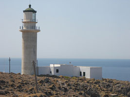
| GR 101 |
Ágios Fokás (Paros Island)
latitude 37° 5' 25" N longitude 25° 7' 56.3" E
Located on a promontory sheltering the north side of the harbor of Páros. (E 4286) ARLHS # GRE-052
Photo courtesy Alex Trabas [ListOfLights] |
|
| GR 102 |
| Spathi (Serifos Island)
latitude 37° 6' 52.2" N longitude 24° 29' 48.8" E
Located on the southern tip of the island. Accessible by road (4WD recommended). ARLHS # GRE-121
Photo courtesy Dimitris Tsapelas [Flickr] |
| GR 103 |
Kórakas (Náousa, Paros Island)
latitude 37° 9' 16" N longitude 25° 13' 28.1" E |
Located on a promontory sheltering the west side of the harbor of Náousa. Accessible by a primitive road (4WD recommended). photo
Don't confuse this with the similarly named, but physically not colocated light in the South. GR 178 ARLHS # GRE-087 |
| GR 104 |
Gaiduronísi (Dhidhimi, Siros Island)
latitude 37° 25' 37.4" N longitude 24° 58' 18.7" E |
Built by French engineers, this is the tallest Greek lighthouse. Located on an island about 3 km east of Ermoúpolis, Síros. photo ARLHS # GRE-069 |
| GR 105 |
Armenistís (Mykonos Island)
latitude 37° 29' 23.6" N longitude 25° 18' 50.4" E
Perched spectacularly above the sea, this lighthouse is a popular tourist attraction. Located on the northwestern tip of Míkonos, about 6 km north of Míkonos Chóra. Accessible by road. ARLHS # GRE-043
Photo courtesy D1v1d [Flickr] |
|
| GR 106 |
| Papas (Ikaria Island)
latitude 37° 30' 38.2" N longitude 25° 58' 44" E
This lighthouse marks the broad passage between Ikaría and Míkonos, leading to the central Aegean. Located on Ákra Papas, the southwestern tip of the island. The light is not accessible by road, but it may be possible to hike to it. ARLHS # GRE-103
Photo courtesy Nikos Karaftis [panoramio] |
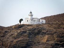
| GR 107 |
Támelos (Kéa Island)
latitude 37° 31' 20" N longitude 24° 16' 36" E
Located on Ákra Támelos, the southern point of Kéa. There is a road to the lighthouse; local guidance may be needed. ARLHS # GRE-126
Photo courtesy Irene-Angelica Chounta [Flickr] |
|
| GR 108 |
| Liváda (Tinos Island)
latitude 37° 36' 39" N longitude 25° 15' 11.6" E
Located at the end of a spectacular narrow promontory at the northeastern corner of Tínos, near the village of Liváda. Accessible by a hiking trail. ARLHS # GRE-090
Photo courtesy Yiannis G. [Flickr] |
| GR 109 |
Planítis (Pánormos, Tínos Island)
latitude 37° 39' 32.5" N longitude 25° 4' 5.3" E |
Planítis is an island sheltering the north side of the bay of Pánormos, on the north coast of Tínos. photo ARLHS # GRE-109 |
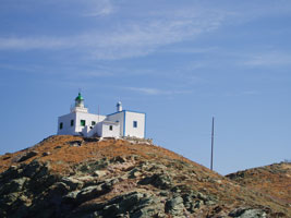
| GR 110 |
Ágios Nikólaos (Kéa Island)
latitude 37° 40' 2.1" N longitude 24° 18' 50.1" E
Located at the end of a narrow peninsula protecting the north side of the harbor of Vourkarió, the principal port of Kéa, on the northwest side of the island. ARLHS # GRE-050
Photo courtesy Dimitris Tsapelas [Flickr] |
|
|
|
| GR 111 |
Disvato (Tinos Island)
latitude 37° 40' 21.9" N longitude 24° 58' 0.5" E |
Located on an island off the northwestern tip of Tínos, the lighthouse guides ships through the Tínos-Ándros Strait. photo ARLHS # GRE-062 |
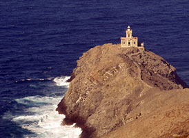
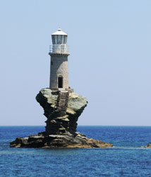
| GR 112 |
Turlitis (Andros Island, Turlitis, Ándros Chóra)
latitude 37° 50' 35.2" N longitude 24° 56' 47.2" E
This location of this lighthouse, perched on an isolated rock, is unique among Greek lighthouses. There are no keeper's quarters; stairs cut into the rock lead down to a crude landing site. Located on a rock in the harbor of Ándros Chóra. ARLHS # GRE-127
Photo courtesy anjči [Flickr] |
|
| GR 112V |
Akra Vinglostasi |
ARLHS # GRE-181 |
| GR 113 |
Gávrio (Andros Island)
latitude 37° 52' 31.5" N longitude 24° 43' 36.5" E |
Located atop a steep hill on the west side of the entrance to the harbor of Gávrio, the principal port of Ándros, near the northwestern end of the island. Savas says the lighthouse is accessible by road from Gávrio, although the terrain looks rather rough. photo ARLHS # GRE-070 |
| GR 114 |
Griá (Andros Island)
latitude 37° 53' 55.2" N longitude 24° 57' 17.8" E
Although it is rather remote, this lighthouse deserves to be better known. Located on a spectacular promontory on the north side of Ándros, about 5 km north of Ándros Chóra. ARLHS # GRE-072
Photo courtesy Miltos Anagnostou [Flickr] |
|
| GR 115 |
Fasa (Andros Island)
latitude 37° 57' 49.5" N longitude 24° 42' 8.3" E |
The lighthouse guides vessels through the strait, about 10 km wide, that separates Ándros from Évvoia. Located near the western tip of Ándros, about 15 km north northwest of Gávrio. Accessible by road. photo ARLHS # GRE-064 |
| GR 116 |
Passas (Oinousés)
latitude 38° 30' 2.1" N longitude 26° 17' 36.6" E |
This lighthouse marks a major hazard in the northern end of the Chíos Strait, which separates Chíos from the Turkish coast. Located on a small island off the east end of the larger island of Oinousés (or Inouses), about 25 km northeast of Chíos town and 8 km west of the Turkish coast. ARLHS # GRE-104 |
| GR 117 |
Kokinopulo (Ágios Georgios, Psara Island)
latitude 38° 32' 10.5" N longitude 25° 36' 33.3" E |
Located on Ákra Ágios Georgíos (Cape St. George), the cape at the southeastern corner of Psará. photo ARLHS # GRE-054 |
| GR 118 |
Prasouda (Rock Island)
latitude 38° 39' 52.3" N longitude 24° 14' 59.9" E
The light guides ships around a prominent cape on the northeastern coast of Euboea. Located on a small island about 12 km northeast of Kimi. ARLHS # GRE-112
Photo courtesy Dionisis Kapsaskis [panoramio] |

|
| GR 119 |
Lithári (Skiros Island)
latitude 38° 46' 29.2" N longitude 24° 40' 53.8" E |
Skíros (Skyros), the southernmost of the Sporades, is located about 40 km northeast of Kimi, Euboea. The island is about 25 km long and has a population of about 3000. The lighthouse is located on Ákra Lithári, the southeastern tip of the island. ARLHS # GRE-092 |
| GR 120 |
Mitilíni Inner Harbor
latitude 39° 6' 11.4" N longitude 26° 33' 33.8" E
Located at the end of a short pier on the south side of the entrance to the inner harbor. (E 4608)
Photo courtesy Alex Trabas [ListOfLights] |
|
| GR 121 |
Mitilíni (Ákra Kastro, Fykiotrypa)
latitude 39° 6' 42.4" N longitude 26° 34' 2.9" E |
Located on a promontory about 1.2 km northeast of the Mitilíni waterfront. Accessible by a short walk from the coastal road. photo |
| GR 122 |
Megalonísi (Lesvos Island, Sígri, Meganísi)
latitude 39° 12' 45.6" N longitude 25° 49' 56.8" E
Megalonísi (Big Island) is an island sheltering the harbor of Sígri, a port at the western end of Lésbos. Located near the southern end of Megalonísi. The island is accessible by boats that can be hired daily from Sígri except in bad weather. ARLHS # GRE-097
Photo courtesy Stratos Loukos [panoramio] |
|
| GR 123 |
Molivos
latitude 39° 22' 44.2" N longitude 26° 11' 2.2" E |
Located on Ákra Molivos, a promontory on the north coast of Lésbos about 2 km northeast of Míthimna; this is only 8 km southeast of Cape Baba, Turkey. Accessible by a short walk from nearby roads. photo |
| GR 124 |
Kombi (Limnos Island)
latitude 39° 23' 22.8" N longitude 26° 20' 29.6" E |
Located on Ákra Kórakas, at the northeastern corner of Lésbos about 40 km northwest of Mitilíni. According to Savas, the site is difficult to reach on foot. photo ARLHS # GRE-083 |
| GR 125 |
Psathoúra (Alonisos Island)
latitude 39° 30' 12.9" N longitude 24° 10' 50.3" E |
Psathoúra is a small, uninhabited island at the northeastern end of the Voriai Sporades. The light guides ships bound for Thessaloníki around this island chain. Located at the highest point of the island. photo ARLHS # GRE-029 |
| GR 126 |
Kastro (Limnos Island) |
Above Myrina, Limno's capital, towers the kastro. It was probably an acropolis in antiquity, but what we see today dates back to the Venetians. ARLHS # GRE-079 |
| GR 127 |
Posidhion (Chalcidice) |
ARLHS # GRE-111 |
| GR 128 |
Plaka (Limnos Island) |
This lighthouse was manufactured in 1912 from the French company of Lighthouses and is found in the end of Plakas cape in Limnos island. The altitude of stone tower is 18 m and the height of focal plane is 50 m. Included in the Greek lighthouses network afterwards the Balkan Wars 1913. ARLHS # GRE-107 |
| GR 130 |
Kandeliusa (Imia Island)
latitude 36° 30' 17.4" N longitude 26° 58' 26" E |
Located on a small island about 18 km south of the southwestern tip of Kos and about 15 km southwest of Nísiros. ARLHS # GRE-014 |
| GR 131 |
Agrelios (Lesvos Island) |
This lighthouse was manufactured in 1930. The altitude of tower is 5 meters and the height of focal plane is 60 meters. The lighthouse located in the end of homonym cape of Lesvos Island and the access to this is by road from the village Agrilia. ARLHS # GRE-037 |
| GR 132 |
Sykaminia (Lesvos Island) |
This lighthouse first worked on 1863 and manufactured by the French company of lighthouses near to Sikaminia village in Lesvos Island. The altitude of tower is 6.5 m and the height of focal plane is 20 m. Included in the Greek lighthouses network afterwards the Balkan Wars the 1912-13.
In the begining was fuctioned with "live" flame that was raised with mechanism of pulleys in a metal column. In 1981 it was supplied with electricity. The access to the lighthouse is difficult from the land. Leaving behind Molivos and Eftalu villages, through tight paths and enough walk, arrive in the cape Korakas, where the lighthouse stands proud but lonely just 6 naval miles opposite from Turkish coast. ARLHS # GRE-099 |
|
|
