|
The lighthouses of Turkey along the Bosporous. Lights are numbered from the south to the north. You can almost always click on the light to go to it's specific (larger resolution) copy. Each lighthouse is linked to (in our editorial opinion) the best reference site for that light. I would like to include directions on how to get to these lights. If you know such data, could you eMail me and I'll post it here (with your choice of attribution.) mailme |
|
| TR 56 |
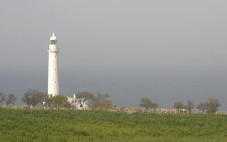
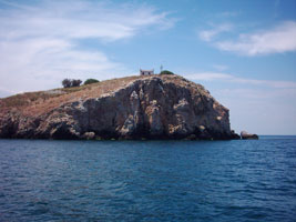
Bati (Bozcaada)
latitude 39° 50' 11.6" N longitude 25° 57' 49.5" E |
Bozcaada is an island about 6 km off the Turkish coast about 20 km southwest of the entrance to the Dardenelles. The island is accessible by ferry from Geyikli. Located on the western tip of the island.
Flickr ARLHS # TUR-001 |
| TR 57 |
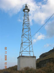
Tavsan Adasi |
ARLHS # TUR-050 |
| TR 58 |
Mehmetcik (Cape Helles)
latitude 40° 2' 43.9" N longitude 26° 10' 44.9" E
The original lighthouse, a 33 ft. stone tower, did not survive World War I. Cape Helles is the cape at the north (European) side of the Dardanelles (or the Hellespont, as it was known in ancient Greece). Located on the point of the cape near Seddülbahir.
ARLHS # TUR-042
Photo courtesy Tim Hendrix [Flickr] |
|
| TR 59 |
Kanlidere (Kepez)
latitude 40° 5' 37.8" N longitude 26° 21' 47.5" E |
The first lighthouse was also a cast iron tower. Located on a prominent cape on the Asiatic side of the strait about 10 km southwest of Çanakkale.
ARLHS # TUR-033 |
| TR 60 |
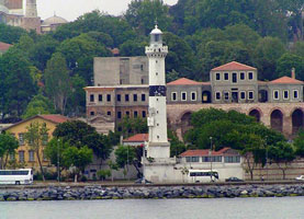
Canakkale Kalesi (Çimenlik)
latitude 40° 8' 49.5" N longitude 26° 23' 53.2" E |
The light is at the foot of Çimenlik Kalesi (castle), built by Sultan Mehmet the Conqueror in 1452. The first two lights were mounted on the castle and the third was a skeletal tower. Çanakkalle is on the southwest (Asian) side of the strait at the first major turn for northbound ships. Located on the bank of the strait on the south side of Çanakkale.
trekearth ARLHS # TUR-017 |
| TR 61 |
Eceabat Range Front |
The range guides southbound vessels approaching a near right-angle turn in the strait. Located on a hillside in Eceabat, on the west (European) side of the strait.
|
| TR 62 |
Eceabat Range Rear
latitude 40° 11' 5.3" N longitude 26° 21' 8.8" E |
Located on a wooded hillside in Eceabat, on the west (European) side of the strait.
|
| TR 63 |
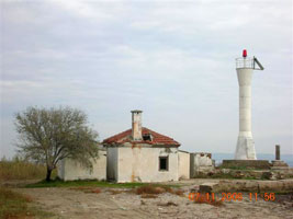
Kaleköy
latitude 40° 14' 4.4" N longitude 25° 53' 46.3" E
This light guides ships into the harbor of Kaleköy, the principal port of Gökçeada. Gökçeada, the largest Turkish island in the Aegean Sea, is about 16 km northwest of Cape Helles, the entrance to the Dardenelles. Located atop a steep bluff on the east side of the harbor of Kaleköy, on the north side of Gökçeada.
Photo courtesy Coastal Safety Commission [Kiyi Emniyeti] |
|
| TR 64 |
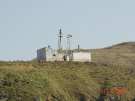
| Karakova
Located on a point of land projecting from the European side of the strait about 9 km southwest of Gelibolu
Photo courtesy Coastal Safety Commission [Kiyi Emniyeti] |
| TR 65 |
Korkut |
ARLHS # TUR-039 |
| TR 66 |
Gelibolu
latitude 40° 24' 34.9" N longitude 26° 40' 55" E |
This lighthouse marks the northern entrance to the narrow portion of the Dardanelles. Gelibolu (Gallipoli) was the scene of an unsuccessful siege by Allied troops in 1915, during World War I. The battlefields are a major tourist attraction, but the lighthouse doesn't get much attention from visitors. Located on a bluff in Gelibolu, on the northwest side of the strait.
photo ARLHS # TUR-023 |
| TR 67 |
Zincirbozan Banki (Sea of Marmara) |
ARLHS # TUR-061 |
|
|
| TR 68 |
Fener Adasi
latitude 40° 27' 43.5" N longitude 28° 4' 0.7" E
"Fener Adasi" means "lighthouse island." Located on a small island in the Mola Adalari (Mola archipelago) about about 2.5 km east southeast of Kapsül Burnu and 11 km northeast of Bandirma on the south coast of the Sea of Marmara.
ARLHS # TUR-003
Photo courtesy Fikret Gedik [panoramio] |
|
| TR 69 |
Ince Burun (West Entrance Point Sea of Marmara) (Karabiga Karaburun)
latitude 40° 28' 29.6" N longitude 27° 17' 8.2" E |
This is one of at least four Ince Burnu (Sharp Cape) lighthouses in Turkey; the name Karaburun (Black Cape) is preferable although there is another Karaburun lighthouse on the Black Sea coast of Thrace (see below). Located on a rugged promontory on the south side of the eastern entrance to the Dardanelles from the Sea of Marmara.
TR78 ARLHS # TUR-028 |
| TR 70 |
Kapsül
latitude 40° 28' 39.1" N longitude 28° 2' 3.7" E |
Located about 1.6 km north of Çakilköy, on the northeastern tip of the club-shaped Erdek Peninsula.
ARLHS # TUR-034 |
| TR 71 |
Baylos
latitude 40° 29' 40.4" N longitude 27° 40' 55.1" E |
According to NGA, the previous light was on a skeletal tower. Located at the northwestern tip of the Erdek Peninsula just west of İlhanköy.
photo |
| TR 72 |
Ekinlik (Adasi)
latitude 40° 30' 49.3" N longitude 27° 28' 40.2" E |
Located on Avsar, a small island about 2 km west of Turkeli.
photo ARLHS # TUR-052 |
| TR 73 |
Boz Burnu
latitude 40° 32' 3" N longitude 28° 46' 54.3" E |
Located in a rugged area at the tip of the Boz Peninsula, which projects into the southeastern corner of the Sea of Marmara.
photo |
| TR 74 |
Ince Burnu (Sea of Marmara)
latitude 40° 33' 23.7" N longitude 26° 59' 44.6" E |
Located on a prominent cape on the northwest side of the Dardanelles entrance about 15 km southwest of Sarköy.
photo ARLHS # TUR-027 |
| TR 75 |
Değirmen Burnu (Imrali)
latitude 40° 33' 53.9" N longitude 28° 33' 15.1" E |
Located at the northeastern tip of the island of Imrali, which is about 16 km due west of Boz Burnu. The site of a prison, the island is accessible by ferry from Istanbul and from Mudanya on the south shore of the Sea of Marmara. Not to be confused with the similarly named light in the south.
TR 38 |
| TR 76 |
Marmara Feneri |
ARLHS # TUR-008 |
| TR 77 |
Asmali
latitude 40° 37' 56.1" N longitude 27° 45' 31.2" E
Located on a small island off the eastern tip of Marmara, the largest island in the sea of the same name.
Photo courtesy Habib Atinc [panoramio] |
|
| TR 78 |
Fener (Karaburun) |
Note that "Fener" means simply "lighthouse". And there are several other lights with the name Kara Burun. So, ... the possibility of a duplicate is greater than zero. ARLHS # TUR-022 |
|
|
| TR 79 |
Hosköy (Hora)
latitude 40° 42' 16.6" N longitude 27° 18' 25.7" E |
This historic lighthouse, on the west side of the Sea of Marmara, guides ships into the Dardanelles. Located near the village of Hoşköy, about 20 km northeast of the larger town of Sarköy.
photo ARLHS # TUR-025 |
| TR 80 |
Dil Burnu
latitude 40° 44' 28.5" N longitude 29° 30' 51.5" E |
Dil Burnu is a sharp-pointed cape projecting abruptly into the south side of the entrance to the Gulf of Izmit. The Izmit Bay Bridge, now under construction, will cross the bay at this location. Located at the tip of the cape, about 20 km east northeast of Yalova.
|
| TR 81 |
Yelkenkaya
latitude 40° 45' 20.4" N longitude 29° 21' 16.2" E |
This lighthouse marks the north side of the entrance to the Gulf of Izmit, a narrow eastward arm of the Sea of Marmara. The house is clearly in use, but we do not know for what purpose. Located on a prominent cape about 3 km west of Darica.
photo ARLHS # TUR-054 |
| TR 82 |
Kave Burnu
latitude 40° 46' 13.4" N longitude 29° 31' 11.2" E |
Located on a promontory on the north side of the Gulf of Izmit, directly opposite Dil Burnu.
|
| TR 83 |
Pendik South Breakwater
latitude 40° 51' 32.9" N longitude 29° 15' 9.3" E |
Located on the south breakwater at Pendik, about 25 km southeast of Istanbul.
|
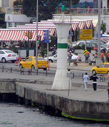
| TR 85 |
Yesilköy Burnu (Agios Stefanos, St. Stefanos)
latitude 40° 57' 30.7" N longitude 28° 50' 19.9" E |
This lighthouse serves as a landfall light for vessels arriving in Istanbul from the Sea of Marmara. Located at the end of the Fener Yolu Caddesi in Yeşilköy, about 12 km southwest of downtown Istanbul, near the international airport.
photo ARLHS # TUR-055 |
| TR 86 |
Marmara Ereğli (1861) (Sea of Marmara)
latitude 40° 58' N longitude 27° 58' E |
This lighthouse was replaced recently by a much higher tower (next entry). We do not know the fate of the historic lighthouse, but we hope it was not demolished. Located on a sharp promontory at Marmara Ereğli, about 32 km east of Tekirdag on the central north coast of the Sea of Marmara
photo ARLHS # TUR-059 |
| TR 87 |
Marmara Ereğli (2004)
latitude 40° 58' 6.3" N longitude 27° 57' 54.4" E |
Located on a sharp promontory at Marmara Ereğli, about 32 km east of Tekirdag on the central north coast of the Sea of Marmara.
|
| TR 88 |
Fenerbahce (Fenerbaçe, Fener Burnu, Seraglio Point)
latitude 40° 58' 5" N longitude 29° 1' 55.4" E |
Located on an island, separated from the mainland by only a narrow channel, near the end of the Fener Kalamis Caddesi about 1.5 km south of Kadiköy.
photo
Note: the Yoroz lighthouse near Trabzond in northeastern Anatolia is also called Fener Burnu (Lighthouse Point). TR 166 ARLHS # TUR-021 |
| TR 89 |
Kadiköy Breakwater
latitude 40° 59' 33.2" N longitude 29° 53.5" E |
Located at the end of a short breakwater on the south side of Kadiköy harbor, just southeast of the entrance to the Bosporus. Accessible by walking the pier.
Flickr |
| TR 90 |
Haydarpasa Breakwater Southeast (Istanbul) |
ARLHS # TUR-024 |
| TR 91 |
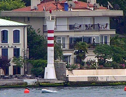
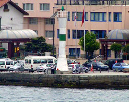
Ahirkapi Burnu (Istanbul)
latitude 41° 22.6" N longitude 28° 59' 7.8" E
This lighthouse stands on the west side of the entrance to the Bosporus from the Sea of Marmara. Located on the land side of the waterfront boulevard, the Kennedy Caddesi, on Ahirkapi Burnu.
(E 4903) ARLHS # TUR-056
Photo courtesy Alex Trabas [ListOfLights] |
|
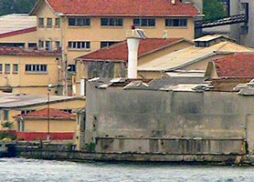
| TR 92 |
| Haydarpaşa Outer Breakwater Northwest
Located at the northern end of the detached Haydarpaşa breakwater, which shelters the commercial harbor on the Asiatic side of the entrance to the Bosporus.
(E 4904)
Photo courtesy Captain Peter Mosselberger [ListOfLights] |
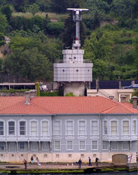
| TR 93 |
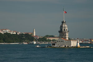
Kizkulesi (Maiden's Tower, Leander's Tower)
latitude 41° 1' 16.1" N longitude 29° 14.8" E
The first structure known to have been built here was a fortress built by the Athenian general Alcibiades in 408 BC. The first record of a lighthouse dates from 1509, in the early Ottoman period. The present form of the tower results from reconstructions by the Ottoman emperors Mustafa III in 1763 and Mahmud II in 1832. Today the building houses a museum and a popular restaurant. Located on an islet 200 m off the Asiatic shore at the southern entrance to the Bosporus. Accessible by passenger ferries from both sides of the strait.
ARLHS # TUR-038
Photo courtesy Adam Franco [Flickr] |
|
| TR 94 |
| Salipazari Wharf
latitude 41° 1' 42" N longitude 28° 59' 18" E
Located on a small wharf on the west side of the Bosporus opposite the Kiz Kulesi (previous entry).
(E 4903.7)
Photo courtesy Captain Peter Mosselberger [ListOfLights] |
| TR 95 |
Çengelköy
latitude 41° 3' 13.5" N longitude 29° 3' 6.3" E
For northbound ships the light marks the first sharp turn in the Bosporus, just north of the Boğaziçi Bridge. Located on the waterfront on the east bank of the Bosporus in the Çengelköy neighborhood.
(E 4938.3)
Photo courtesy Captain Peter Mosselberger [ListOfLights] |
|
| TR 96 |
| Arnavutköy (Akinti Burnu)
latitude 41° 4' 4.1" N longitude 29° 2' 46.1" E
Located on the west side of the Bosporus in the Arnavutköy neighborhood, halfway between the Boğaziçi and Sultan Mehmet bridges.
(E 4940)
Photo courtesy Captain Peter Mosselberger [ListOfLights] |
| TR 97 |
Kandilli Burnu
latitude 41° 4' 26.4" N longitude 29° 3' 21.9" E
Located on a promontory at a sharp bend in the Bosporus in the Kandilli neighborhood, on the east bank of the Bosporus.
(E 4944)
Photo courtesy Captain Peter Mosselberger [ListOfLights] |
|
| TR 98 |
Aşiyan Burnu
latitude 41° 4' 57.4" N longitude 29° 3' 24.1" E |
Located on the west side of the Bosporus at a pronounced bend in the channel in the Aşiyan neighborhood.
|
| TR 99 |
Balta Limani
latitude 41° 5' 57.3" N longitude 29° 3' 15.4" E
Located on the west side of the Bosporus in the Baltalimani neighborhood, north of the Sultan Mehmet Bridge.
(E 4947)
Photo courtesy Captain Peter Mosselberger [ListOfLights] |
|
| TR 100 |
Istinye
latitude 41° 6' 48.6" N longitude 29° 3' 41" E |
Located on a promontory on the west side of the strait at Istinye, opposite Pasabahce (below).
TR 102 |
| TR 102 |
Pasabahce
latitude 41° 6' 58.2" N longitude 29° 5' 28.5" E
Located on a short pier at Pasabahce, on the Asiatic side of the Bosporus about halfway between the Black Sea and downtown Istanbul. This is an industrial area and may be closed to the public.
(E 4949)
Photo courtesy Captain Peter Mosselberger [ListOfLights] |
|
|
|
