|
Greece's continental boundaries are shaped like an inverted "U". This page covers those lights in the south of Greece, thus the two tip's of the inverted U. You can almost always click on the light to go to it's specific (larger resolution) copy. Each lighthouse is linked to (in our editorial opinion) the best reference site for that light. I would like to include directions on how to get to these lights. If you know such data, could you eMail me and I'll post it here (with your choice of attribution.) mailme |
|
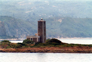
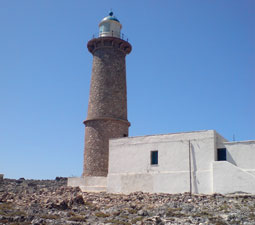
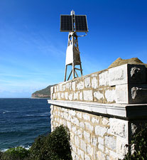
| GR 132 |
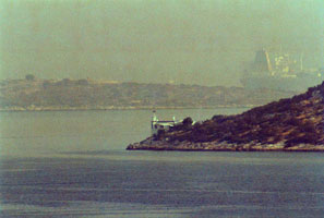
Kafkalida (Rock Island)
latitude 37° 56' 24.7" N longitude 24° 7' 14.9" E
Kafkalida is a small island off Cape Killini at the northwestern corner of the Peloponnisos. Located at the highest point of the island. Accessible only by boat; transportation can be hired in Kyllini. (E 3996) ARLHS # GRE-074
Photo courtesy Alex Trabas [ListOfLights] |
|
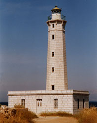
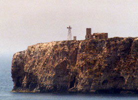
| GR 133 |
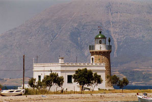
| Drepano (Patra)
latitude 38° 20' 20.4" N longitude 21° 50' 57.2" E
Located on a point of land at the base of a sandy spit about 8 km northeast of the Rion-Antirion Bridge. (E 3948) ARLHS # GRE-061
Photo courtesy Alex Trabas [ListOfLights] |
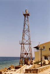
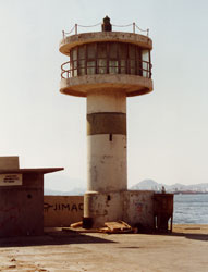
| GR 134 |
Patras Breakwater |
ARLHS # GRE-105 |
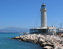
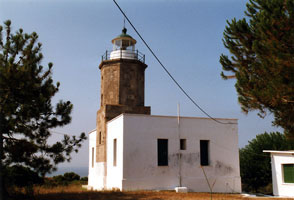
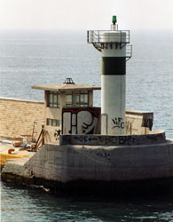
| GR 135 |
Patras (replica)
latitude 38° 14' 42.3" N longitude 21° 43' 33.6" E
The original was located at the end of a pier at the foot of Agios Nikolaos street in Patras but was demolished in 1972, a tragic loss of a valuable and valued civic landmark. Located on the waterfront at the west end of the harbor of Patras.
Photo courtesy Adam Balch [Flickr] |
|
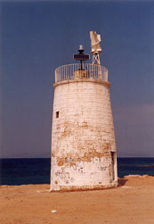
| GR 136 |
| Likoporia
latitude 38° 8' 9.4" N longitude 22° 29' 27.3" E
Located on a point of land on the south side of the Gulf of Corinth directly opposite the Psaromyta lighthouse and about 2 km west of the village of Likoporia. (E 3967) ARLHS # GRE-135
Photo courtesy Alex Trabas [ListOfLights] |
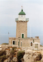
| GR 137 |
Melagavi (Gulf of Corinth)
latitude 38° 1' 42.3" N longitude 22° 50' 58.8" E
Cape Ireon projects westward into the Gulf of Corinth and shelters the bay leading to the city of Kórinthos (Corinth). Located on the point of the cape about 15 km west of Loutraki. (E 3972) ARLHS # GRE-018
Photo courtesy Alex Trabas [ListOfLights] |
|
| GR 138 |
| Susaki (Korinthos, Sousaki)
latitude 37° 54' 46" N longitude 23° 3' 27" E
This lighthouse guides westbound ships approaching the Corinth Canal, which connects the Saronic Gulf to the Gulf of Corinth. Located on the Saronic Gulf on a point of land about 4 km east of Isthmia, the eastern entrance to the canal. (E 4162) ARLHS # GRE-136
Photo courtesy Alex Trabas [ListOfLights] |
| GR 139 |
Dana (Poros Island)
latitude 37° 31' 35.1" N longitude 23° 25' 36.6" E |
The island of Poros lies at the southern end of the Saronic Gulf, just off the coast of the Peloponnisos. Located at the western tip of the island, marking the entrance to the narrow strait between Poros and the mainland. photo ARLHS # GRE-058 |
| GR 140 |
Ákra Stavros
Located at the southern tip of the island of Poros, guiding vessels entering the narrow strait between the island and the mainland. (E 4141)
Photo courtesy Alex Trabas [ListOfLights] |
|
| GR 140Z |
Zurva (Hydra Island, Zourvas)
latitude 37° 21' 52.8" N longitude 23° 34' 36.8" E |
This is a copy of the original lighthouse, which was destroyed by German troops during World War II. Located at the eastern tip of Hydra, about 10 km east of Idra (Hydra), the largest town of the island. Practically inaccessible. ARLHS # GRE-133 |
| GR 141 |
Dokos (Dokos Island)
latitude 37° 19' 52.3" N longitude 23° 21' 23.3" E |
Dokos is one of the Saronic Islands, just off the east coast of the Peloponnisos about 8 km southeast of Ermioni. Attached to the Hydra municipality, the island is uninhabited except for a small Orthodox monastery. Located at the eastern tip of the island. ARLHS # GRE-059 |
| GR 142 |
Spetses (Spetses Island)
latitude 37° 15' 48.1" N longitude 23° 10' 1.9" E |
Spetses is an island in the eastern entrance to the Argolikos Kolpos (Argolic Gulf). The island is about 7 km long by 3 km wide and has a population of about 3500. A popular tourist destination, Spetses is accessible by ferry from Piraeus or Kosta. Located on a promontory sheltering the east side of the harbor of Spetses. photo ARLHS # GRE-063 |
|
|
| GR 143 |
Astros (Gulf of Argolikos)
latitude 37° 24' 52.9" N longitude 22° 46' 8.9" E
Located on a promontory on the east side of the harbor of Astros, a port on the west side of the Argolikos Kolpos (Argolic Gulf). (E 4104) ARLHS # GRE-045
Photo courtesy Alex Trabas [ListOfLights] |
|
| GR 143V |
Velopoula (Parapola)
latitude 36° 55' 39" N longitude 23° 27' 10.8" E |
Velopoula is an isolated, uninhabited island about 27 km off the southeastern peninsula of the Peloponnisos; it is attached administratively to the municipality of Spetses. Located atop the island. photo ARLHS # GRE-032 |
| GR 144 |
Monemvasia
latitude 36° 41' 22.4" N longitude 23° 3' 31.9" E
The lighthouse is part of a medieval fortress. Lighthouse, fortress, and the tiny village of Monemvasia are located on a high, rocky island about 32 km north of Cape Maleas. Accessible by road; the island is connected to the mainland town of Gefyra by a causeway. ARLHS # GRE-098
Photo courtesy Mark Hensley [Flickr] |
|
| GR 145 |
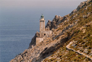
| Maleas (Cape Maleas)
latitude 36° 26' 6.8" N longitude 23° 11' 51.2" E
Cape Maleas is the southeastern tip of the Peleponnisos. Located at the easternmost point of the cape, about 1.5 km north of the southernmost point. Perched on a very steep slope, the lighthouse is difficult to access. (E 4078) ARLHS # GRE-093
Photo courtesy Alex Trabas [ListOfLights] |
| GR 146 |
Akra Zovollo
latitude 36° 25' 42.2" N longitude 23° 7' 49.2" E
Located on a promontory about 7 km west of Cape Maleas, near the southeastern tip of the Peleponnisos. (E 4076) ARLHS # GRE-182
Photo courtesy Alex Trabas [ListOfLights] |
|
| GR 147 |
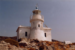
| Kapsali (Kithira Island)
latitude 36° 8' 33.3" N longitude 23° 0.6" E
Located on a promontory protecting the harbor of Kapsali, a port at the southern end of Kythira. (E 4068) ARLHS # GRE-077
Photo courtesy Alex Trabas [liteslist] |
| GR 147P |
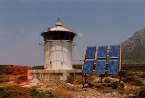
Apolytares (Andikithira Island)
latitude 35° 49' 23.8" N longitude 23° 19' 29.6" E
This lighthouse is an important guide to vessels in the Antikythira Strait, which connects the Mediterranean and Aegean Seas northwest of Crete. Antikythira has a population of about 50. Boat transportation from Kythira can be arranged. Located at the southern tip of the island. ARLHS # GRE-040
Photo courtesy George Dimopoulus [panoramio] |
|
| GR 148 |
| Mudari (Spathi, Kithira Island)
latitude 36° 22' 52.9" N longitude 22° 57' 0.4" E
Located on Cape Spathi, the northern tip of Kythira. Follow the road that approaches the cape and you may be able to walk to the light. (E 4066) ARLHS # GRE-120
Photo courtesy Alex Trabas [ListOfLights] |
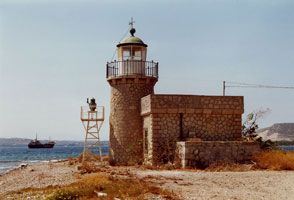
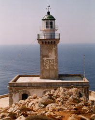
| GR 149 |
Kranai (Gythio)
latitude 36° 45' 15.9" N longitude 22° 34' 32" E
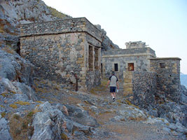
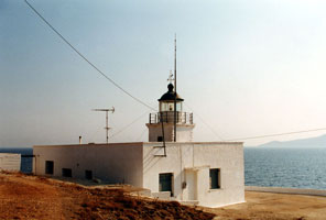
Gythio is a port on the west side of the Lakoniakos Kolpós (Gulf of Lakonia), and Kranai is a small island on the south side of Gythio harbor, connected to the mainland by a causeway. The name is derived from kranos (helmet) because according to ancient legend the warrior Paris left his helmet here after spending his first night with Helen of Troy on the island. This handsome lighthouse is built of marble quarried on the Tenaro peninsula within a few miles of the tower. Savas says that the light station was donated to the Hellenic Maritime Museum in 1989 and is now open to the public. Located at the eastern tip of the island of Kranai. (E 4052) ARLHS # GRE-073
Photo courtesy Alex Trabas [ListOfLights] |
|
| GR 150 |
| Tainaro (Cape Tenaro, Cape Matapan)
latitude 36° 23' 10" N longitude 22° 28' 58.1" E
Ákra Tainaro (Cape Matapan) is the southernmost point of the Greek mainland. Located on the point of the cape, about 10 km south of Vathia. Accessible by road and a short hike. (E 4048) ARLHS # GRE-125
Photo courtesy Alex Trabas [ListOfLights] |
|
|
| GR 151 |
Limeni (Gulf of Messina)
latitude 36° 40' 41.8" N longitude 22° 22' 7.1" E
Located at the south entrance to the harbor of Limeni, on the east side of the Messiniakos Kolpós (Gulf of Messinia), about 3 km northwest of Areopoli. ARLHS # GRE-091
Photo courtesy Stathis Stathakis [trekearth] |
|
| GR 152 |
Kitries (Gulf Of Messina)
latitude 36° 54' 52.1" N longitude 22° 7' 32.4" E |
The lighthouse guides vessels approaching the port of Kalamata. Located on Ákra Kitries, a prominent cape on the east side of the Messiniakos Kólpos (Gulf of Messenia), about 3 km southwest of the village of Kitries. The coastline is fairly rugged in this area, but the lighthouse is apparently accessible by hiking trail. photo ARLHS # GRE-082 |
| GR 153 |
Sapienza (Sapienza Island)
latitude 36° 44' 28" N longitude 21° 41' 49.4" E |
Sapienza is an island about 6 km in length located off Methoni at the southwestern corner of the Peloponnese. Most of the island is set aside as a nature reserve, but it is rarely visited. Located on a high promontory at the south end of the island. photo ARLHS # GRE-116 |
| GR 154 |
Sfakthria (Pylos, Pílos)
latitude 36° 54' 19.5" N longitude 21° 40' 23.3" E
The historic lighthouse is abandoned and falling into ruin. Located on a small island at the west side of the entrance to the bay of Pylos. The active light is on a small skeletal structure. (E 4008) ARLHS # GRE-185
Photo courtesy Alex Trabas [ListOfLights] |
|
| GR 155 |
| Katakolo
latitude 37° 37' 58.3" N longitude 21° 18' 36.8" E
Located at the end of Ákra Katakolon, a sharp promontory about 15 km west of Pirgos. (E 3998) ARLHS # GRE-080
Photo courtesy Alex Trabas [ListOfLights] |
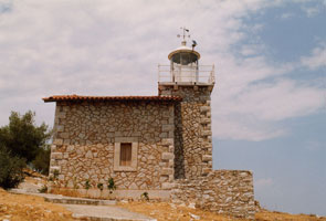
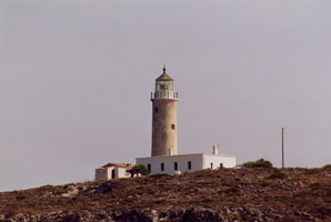
| GR 157 |
Plakakia (Aigina Island)
latitude 37° 45' 42.5" N longitude 23° 25' 4.1" E
Located at the western tip of Aegina, an island in the middle of the Saronic Gulf. The island is readily accessible by ferry from Piraeus and several other locations, and the lighthouse is accessible by road. (E 4144) ARLHS # GRE-108
Photo courtesy Alex Trabas [ListOfLights] |
|
| GR 158 |
Koghi (Salamina Isl.)
latitude 37° 52' 25.4" N longitude 23° 26' 56.4" E |
Salamina (Salamis), the traditional home of the Hellenic Navy, is a large island in the northern end of the Saronic Gulf, just west of Piraeus. The island is easily accessible from the mainland by ferries. Located at the southern tip of the island, about 1.5 km southeast of Kolones. photo ARLHS # GRE-084 |
| GR 159 |
Fylatouri (Ákra Fylatouri)
latitude 37° 58' 47.6" N longitude 23° 33' 7.8" E
Located on a cape about 3 km northwest of Perama, marking the northern entrance to the strait separating Salamina from the mainland. (E 4174)
Photo courtesy Alex Trabas [ListOfLights] |
|
| GR 160 |
Psitalia (Psitalia Island)
latitude 37° 56' 36.4" N longitude 23° 35' 41.9" E |
The traditional landfall light for Piraeus. Psitalia is a small island in the harbor of Piraeus, between the waterfront and Salamina. The island is the site of large sewage and hazardous waste treatment plant and is probably not open to the public. Located at the eastern tip of the island. photo ARLHS # GRE-115 |
| GR 161 |
Ákra Keos Molos (Drapetsonas)
latitude 37° 56' 55.8" N longitude 23° 35' 53.1" E
Located at the end of a mole extending from Ákra Keos, a cape in Piraeus directly opposite the Psitalia lighthouse. (E 4171.5)
Photo courtesy Alex Trabas [ListOfLights] |
|
| GR 162 |
| Piraeus Molos Themistokleus
latitude 37° 56' 12" N longitude 23° 37' 16" E
Located at the end of the south breakwater mole at the entrance to the inner harbor of Piraeus. (E 4178)
Photo courtesy Rainer Arndt [ListOfLights] |
| GR 163 |
Piraeus Molos Vasileus Georgios
latitude 37° 56' 19.1" N longitude 23° 37' 19.6" E
Located at the end of the north breakwater mole at the entrance to the inner harbor of Piraeus. Accessible by walking the mole.
Photo courtesy Ava Babili [Flickr] |
|
| GR 164 |
Fonis (Cape Sunion)
latitude 37° 41' 3.6" N longitude 24° 4' 19.9" E |
Ships rounding Ákra (Cape) Sounion, the eastern tip of the Attic peninsula, sail north through a channel between the mainland and the island of Makronisi ('Big Island'). Located on Ákra Fonias, on the west (mainland) side of the Makronisi channel at the narrowest point, about 4 km south of Lavrio and 8 km northeast of Ákra Sounion. ARLHS # GRE-067 |
| GR 165 |
Vrisaki (Lavrio)
latitude 37° 44' 39.7" N longitude 24° 4' 51.3" E
Located on Ákra Vrisaki, marking the west side of the northern entrance to the Makronisi channel, about 5 km north of Lavrio. (E 4210) ARLHS # GRE-131
Photo courtesy Alex Trabas [ListOfLights] |
|
| GR 178 |
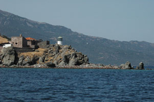
| Kórakas (Lesvos Island, Ákra Skamnia, Sikaminias)
Don't confuse this with the similarly named light in the Aegean sea. GR103 ARLHS # GRE-086
Photo courtesy Stelios Moumtzis |
| GR 179 |
Samos Harbour (Samos Island) |
Heading back to Vathý, detour east to the Straits of Mykále, about 1400m wide, one of the narrowest distances between a Greek island and Turkey, which here means hulking Mt Mykále. There’s a prominent Turkish islet in the middle, with a lighthouse on it. Greek Travel ARLHS # GRE-153 |
| GR 180 |
Akra Plaka (Patmos) |
ARLHS # GRE-178 |
| GR 181 |
Kutsumpa (Simi Island) |
ARLHS # GRE-139 |
| GR 182 |
Ayios Nikolaos (Rhodes Island) |
ARLHS # GRE-187 |
| GR 182 |
Ayios Stefanos (Megisti)
latitude 36° 6' 35" N longitude 29° 37' 56.7" E |
This lighthouse stands atop a small island 6 km southeast of Megísti. Located only 3 km off the southwestern coast of Turkey, Megísti/Kastelorizo is a Greek outpost 110 km east of Rhodes. The lighthouse was built during the French occupation. Located near the southwestern end of the central ridge of the island of Strogilí Megísti (also called Ipsili or Strongili). photo ARLHS # GRE-053 |
| GR 183 |
Ipsili (Strogili Megistis) |
ARLHS # GRE-123 |
|
|
