|
The lights of Turkey along the Aegean Sea (thus South and Southwest Turkey). Lights are numbered from the East to the Northwest. You can almost always click on the light to go to it's specific (larger resolution) copy. Each lighthouse is linked to (in our editorial opinion) the best reference site for that light. I would like to include directions on how to get to these lights. If you know such data, could you eMail me and I'll post it here (with your choice of attribution.) mailme |
|
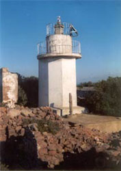
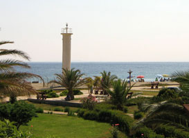
| TR 1 |
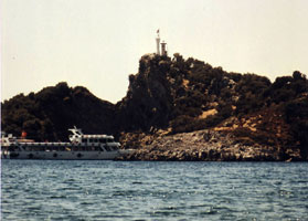
Resulhinzir (Akınc Burnu)
latitude 36° 19' 12.5" N longitude 35° 46' 56.1" E |
Akınc Burnu is the cape at the southern entrance to the Bay of İskenderun. Located on the heights above the point of the cape, about 40 km southwest of İskenderun.
photo ARLHS # TUR-011 |
| TR 2 |
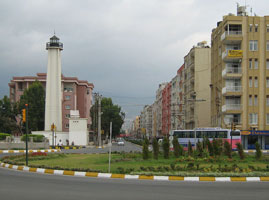
Iskenderun
latitude 36° 31' 49.8" N longitude 36° 2' 17.4" E |
Located on a promontory at Büyükdere, about 12 km southwest of İskenderun.
photo ARLHS # TUR-032 |
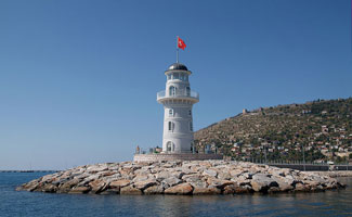
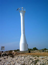
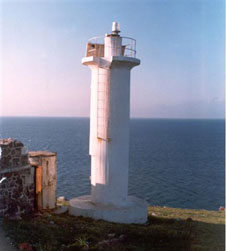
| TR 3 |
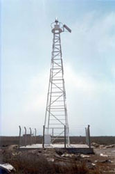
İskenderun Limani (İskenderun Harbor)
latitude 36° 35' 31.1" N longitude 36° 9' 30.5" E
Located on Fener Caddesi (Lighthouse Avenue) on the waterfront of İskenderun.
Photo courtesy Görkem adlı Vikipedi kullanıcısı [wikipedia] |
|
| TR 4 |
Isdemir South Pier |
ARLHS # TUR-031 |
| TR 4N |
Isdemir North Pier |
ARLHS # TUR-030 |
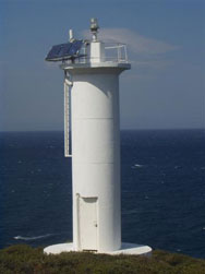
| TR 5 |
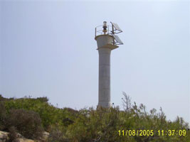
Karataş (Fener Burnu)
latitude 36° 32' 22.1" N longitude 35° 20' 22.4" E |
It appears that the tower on this lighthouse was replaced, but the house may be original. The lighthouse marks the entrance to the Bay of İskenderun, at the extreme northeastern corner of the Mediterranean Sea. Located on Karataş Burnu, also called Fener Burnu (Lighthouse Point), about 5 km southwest of the city of Karataş.
photo |
| TR 6 |
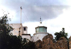
Deli Burnu
latitude 36° 43' 40.2" N longitude 34° 54' 21.4" E
Deli Burnu is the low cape formed by the delta of the Seyhan River, on the east side of the Gulf of Mersin. Located at the point of the cape, about 25 km east of Mersin (Içel).
Photo courtesy Coastal Safety Commission [Kiyi Emniyeti] |
|
| TR 7 |
Mersin (Içel)
latitude 36° 47' 4.7" N longitude 34° 37' 7.1" E |
This is one of the most accessible lighthouses of Turkey's Mediterranean coast, but recent photos are hard to find. Located in Mersin, on the west side of the mouth of the river and about 1.5 km west of the modern harbor entrance.
ARLHS # TUR-043 |
| TR 8 |
Yarim Adası (Bölükada, Ovacik Yarimadasi)
latitude 36° 8' 3.9" N longitude 33° 41' 0.4" E
Yarim Adası (Bölük Ada) is not actually an island, although it appears to be one from a distance; it is connected to the mainland by a narrow isthmus. Located at the southern point of Yarim Adası, about 8 km south of Yeşilovacık.
Photo courtesy Coastal Safety Commission [Kiyi Emniyeti] |
|
| TR 9 |
Anamur Burnu
latitude 36° 1' 2.2" N longitude 32° 48' 11" E |
Cape Anamur is the southernmost point of the Anatolian mainland, and the lighthouse here marks the west entrance to the Cyprus Strait separating Cyprus from Turkey. The cape is a rocky headland projecting abruptly into the Mediterranean. Located at the point of the cape, about 8 km southwest of the city of Anamur.
Flickr ARLHS # TUR-062 |
| TR 10 |
Alanya Dildarde
latitude 36° 31' 49.5" N longitude 31° 59' 29.7" E
Alanya is a modern resort city with very popular beaches, but looming above the beaches is a mountainous peninsula projecting into the Mediterranean. Atop the peninsula is the old fortified city of Alaiye, now called Alanya Castle, built by the Seljuk Turks in the 13th century as their capital. The lighthouse near the south end of the peninsula, attached to its outer walls. It should be possible to see this lighthouse from Kale (Castle) Road.
ARLHS # TUR-012
Photo courtesy Coastal Safety Commission [Kiyi Emniyeti] |
|
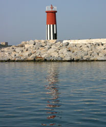
| TR 11 |
| Alanya South Breakwater
latitude 36° 32' 20.3" N longitude 32° 15.8" E
This new lighthouse was built as a tourist attraction. Located at the end of the south breakwater of Alanya harbor.
Photo courtesy Kallerna [wikipedia] |
| TR 12 |
Side (Selimiye)
latitude 36° 45' 58.6" N longitude 31° 23' 2.9" E |
Located at a small boat harbor on a sandy cape projecting into the Gulf of Antalya at Side, a town about 40 km east of Antalya.
photo ARLHS # TUR-045 |
|
|
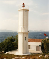
| TR 13 |
Baba Burnu (Antalya)
latitude 36° 50' 45.3" N longitude 30° 45' 28.4" E |
This lighthouse guides vessels into the harbor of Antalya, the principal port of southwestern Turkey. Located on a promontory on the southeast side of the city, about 6 km southeast of the port area. Located just off Lara Caddesi, the coastal road.
photo ARLHS # TUR-065 |
| TR 14 |
Antalya Lee Breakwater |
ARLHS # TUR-064 |
| TR 14N |
Antalya (New Harbor) Main Breakwater |
ARLHS # TUR-063 |
| TR 15 |
Çavus (Adrasar)
latitude 36° 17' 54.8" N longitude 30° 29' 15.9" E
Located on a promontory at the south entrance to the small bay of Adrasar, about 3 km southeast of Çavus and 12 km northeast of Cape Gelidonya.
Photo courtesy Coastal Safety Commission [Kiyi Emniyeti] |
|
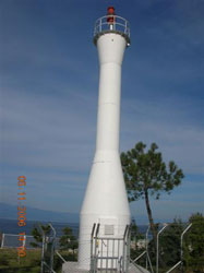
| TR 16 |
| Taslik (Selidonya, Cape Gelidonya)
latitude 36° 13' 9.2" N longitude 30° 24' 34.4" E
One of the most prominent capes of Turkey-s Mediterranean coast, Cape Gelidonya has been the site of countless shipwrecks ever since the dawn of sea travel. The cape is a steep ridge that continues offshore as a line of rocky shoals and islands. The lighthouse is located on the point of the cape, a remote location accessible to backpackers by a hiking trail.
ARLHS # TUR-049
Photo courtesy Yuri Ralchenko [Panoramio] |
| TR 17 |
Kizil Adani (Fethiye Körfezi, Kısılada)
latitude 36° 39' 10.1" N longitude 29° 2' 38" E
In 2008 the Kısılada Tourism Corporation leased the light station, restored the buildings, and opened them to tourists. The Kısıl Adalar are a small group of islands in the Gulf of Fethiye. Located at the southern point of the largest island.
(E 5841) ARLHS # TUR-037
Photo courtesy Alex Trabas [ListOfLights] |
|
| TR 18 |
Peksimet Adasi
latitude 36° 35' 15.9" N longitude 28° 50' 42.6" E |
Located on a tiny island about 3 km offshore at the western entrance to the Gulf of Fethiye.
photo ARLHS # TUR-009 |
| TR 19 |
Baba Adasi
latitude 36° 41' 34.8" N longitude 28° 41' 35.5" E
Located on an island close offshore about 15 km southwest of Dalaman.
(E 5839.45)
Photo courtesy Alex Trabas [ListOfLights] |
|
| TR 20 |
Kadirga Burnu
latitude 36° 43' 49.2" N longitude 28° 18' 10" E |
Kadirga Burnu is the cape at the western entrance to the Gulf of Marmaris. Located at the tip of the cape, a very remote location; may be accessible only by boat.
photo |
| TR 21 |
Keçi Adasi (Keç Adasi, Marmaris)
latitude 36° 47' 53.5" N longitude 28° 15' 33.9" E |
The northern end of the Gulf of Marmaris is nearly closed off by the island of Keçi Adasi (Goat Island) and the Adaköy peninsula. This lighthouse marks the west side of the narrow strait between the island and the peninsula. Located on an islet off the southeastern tip of Keçi Adasi.
photo |
| TR 22 |
Deveboynu
latitude 36° 41' 12.5" N longitude 27° 21' 48.5" E
Deveboynu Burnu (Camels'Neck Point) is the extreme southwestern corner of Anatolia, located at the tip of the long and narrow Datça peninsula. The lighthouse is at the tip of the peninsula. Accessible by a hike of about 1 km from the end of the road.
ARLHS # TUR-019
Photo courtesy Tayfun Sen [Flickr] |
|
| TR 23 |
Ince Burun (South Coast) |
ARLHS # TUR-066 |
|
|
| TR 24 |
Ince Burnu (Agean Sea) (Kerme Korfezi) |
ARLHS # TUR-029 |
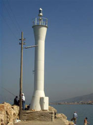
| TR 25 |
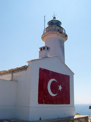
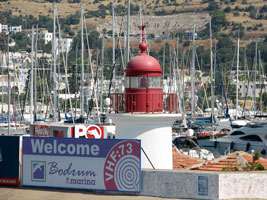
Bodrum West Breakwater
latitude 37° 1' 56.5" N longitude 27° 25' 29.8" E
Bodrum, the modern city on the site of the ancient Greek city of Helikarnassus, is now a very popular tourist resort, and its historic harbor is usually crowded with yachts. The lighthouse is located at the end of the short west breakwater.
(E 4730) ARLHS # TUR-015
Photo courtesy Guenther Hess [ListOfLights] |
|
| TR 26 |
| Hüseyin (Fener Burnu)
latitude 36° 57' 53.2" N longitude 27° 15' 50.7" E
This lighthouse marks the Kos Channel, a 5 km wide passage between the Turkish mainland and the Greek island of Kos. Located on the cape on the west side of Gokdiken and about 4 km south of Turgutreis.
ARLHS # TUR-026
Photo courtesy rswirkula [Panoramio] |
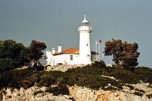
| TR 27 |
Turgutreis West Breakwater
latitude 36° 59' 53.4" N longitude 27° 15' 17.4" E |
These lighthouses were built as part of a marina development project at Turgutreis. The town is named for a 15th century Ottoman admiral, Turgut Reis. Located at the end of the main (west) breakwater at Turgutreis, probably accessible by walking the breakwater.
Flickr |
| TR 28 |
Turgutreis East Breakwater
latitude 36° 59' 56.9" N longitude 27° 15' 21.4" E |
Located at the end of the east breakwater at Turgutreis.
photo |
| TR 29 |
Ortakent (faux) |
Associated with a large resort hotel, this may be an active, privately maintained lighthouse.
Flickr |
| TR 30 |
Altin Ada |
ARLHS # TUR-013 |
| TR 31 |
Tekagac
Located on a promontory on the Gulf of Mandalya about 6 km southwest of Yenihisar.
ARLHS # TUR-051
Photo courtesy Coastal Safety Commission [Kiyi Emniyeti] |
|
| TR 32 |
| Kusadasi Yacht Harbor West Breakwater
latitude 37° 52' 2.8" N longitude 27° 15' 34" E
Located on the main breakwater of the small boat harbor at Kusadasi.
Photo courtesy Jackie Kever [Flickr] |
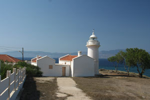
| TR 33 |
Kusadasi (Güvercin Adasi)
latitude 37° 51' 49.8" N longitude 27° 14' 49.6" E
Kuşadasi ("Bird Island") is a resort town and cruise ship port on the Turkish mainland northwest of the Greek island of Samos. The ruins of ancient Ephesus are nearby. The town got its name from the island on which the lighthouse is located, since the island is shaped like a bird's head. Located at the northwest point of the island, which is connected to the mainland by a causeway.
(E 4664) ARLHS # TUR-041
Photo courtesy Alex Trabas [ListOfLights] |
|
| TR 34 |
Güvercin Adasi (Pigeon Island, Bird Island) |
ARLHS # TUR-072 |
| TR 35 |
Süngükaya Adasi (Fener Adasi )
latitude 38° 17' 33.8" N longitude 26° 11' 42.3" E |
Located on an island in the narrowest passage of the strait between the Turkish mainland and the Greek island of Chios, about 8 km southwest of Çesme.
ARLHS # TUR-048 |
| TR 36 |
Sarpincik Karaburun
latitude 38° 39' 30.4" N longitude 26° 21' 45.1" E |
This Karaburun (Black Cape) is the tip of the peninsula projecting into the Aegean northeast of the Greek island of Chios. Located on a steep bluff at the end of the peninsula, 4 km west of Sarpincik.
photo
Very similar to Severice (below) TR45 ARLHS # TUR-073 |
| TR 37 |
Güzelbaçe (Guzelbahçe)
latitude 38° 22' 42.8" N longitude 26° 53' 8.2" E
Located at the end of the breakwater mole of Güzelbaçe, a town on the south side of the Gulf of İzmir about 25 km west of the city of İzmir.
Photo courtesy Coastal Safety Commission [Kiyi Emniyeti] |
|
| TR 38 |
Degirmen Burnu (Izmir, Foca)
latitude 38° 40' 7.2" N longitude 26° 44' 42.9" E |
The modern city of Foça is built near the ruins of the ancient Greek city of Phocaea. Located at the tip of a peninsula sheltering the west side of the harbor of Foça.
photo
Not to be confused with the light in the West with the same name. TR 75 ARLHS # TUR-006 |
| TR 39 |
Oğlak Adası
latitude 38° 40' 28" N longitude 26° 42' 43.5" E
Located at the western end of a small island at the northern entrance to the bay of Foça.
Photo courtesy Coastal Safety Commission [Kiyi Emniyeti] |
|
| TR 40 |
Aslan Burnu
latitude 38° 44' 24.9" N longitude 26° 44' 33.4" E |
Located on a prominent cape on the east side of the entrance to the Gulf of İzmir, about 7 km north of Foça.
photo |
| TR 41 |
Ilıca Burnu (Aliağa)
latitude 38° 49' 27.9" N longitude 26° 53' 34.9" E
Located on a prominent cape about 9 km northwest of Aliağa.
Photo courtesy Coastal Safety Commission [Kiyi Emniyeti] |
|
| TR 42 |
| Gunes Adasi
latitude 39° 19' 35.2" N longitude 26° 32' 22.9" E
The lighthouse stands atop an island at the northern entrance to the Mytilene Strait separating Turkey from Lesvos. Located about 13 km west of Ayvalik and 10 km east of the Korakas lighthouse on Lesvos.
Photo courtesy Coastal Safety Commission [Kiyi Emniyeti] |
| TR 43 |
Edremit Bozburun
latitude 39° 26' 15.5" N longitude 26° 48' 44.3" E
Bozburun ("Gray Cape") is another very common name on the Turkish coast. Located on a prominent cape about 20 km northeast of Ayvalik.
Photo courtesy Coastal Safety Commission [Kiyi Emniyeti] |
|
| TR 44 |
| Edremit Karaburun
latitude 39° 33' 28.9" N longitude 26° 50' 13.2" E
This little lighthouse seems endangered; it stands unprotected on the beach. Karaburun ("Black Cape") is a very common place name on the Turkish coast, so it usually modified by the name of a nearby town. Located on the beach at the point of the cape in Edremit Karaburun, about 15 km west of the city of Edremit.
Photo courtesy Ertugrul Akyazi [panoramio] |
| TR 45 |
Sivrice
latitude 39° 27' 53.3" N longitude 26° 14' 23" E
Located on a prominent cape about 15 km east of Babakale.
ARLHS # TUR-047
Photo courtesy Coastal Safety Commission [Kiyi Emniyeti] |

|
| TR 46 |
Baba Burnu (Babakale)
latitude 39° 28' 46.9" N longitude 26° 3' 50.1" E |
The fort, Baba Kalesi or Babakale, was built by Sultan Ahmed II in the late 1720-s to guard against pirates. Baba Burnu is the westernmost point of the Anatolian mainland, which makes it also the extreme western tip of the Asian continent. The lighthouse also marks the north side of the entrance to the strait between Turkey and the Greek island of Lesvos. Located atop the fortress at the point of the cape in Babakale.
Flickr |
| TR 47 |
Mermer Burnu (Tuzburnu)
latitude 39° 47' 59.1" N longitude 26° 4' 51.9" E |
Located at the southeastern tip of Bozcaada, where it guides vessels through the strait between the island and the mainland.
photo |
|
|
 Greece

