|
The lights on Cyprus (both the Turkish held north and independent South). Lights are numbered clockwise from the left point |
|
| CY 1 |
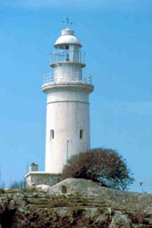
Cape Akamas
latitude 35° 5' 27.6" N longitude 32° 16' 55.6" E |
Located atop the bluff at the westernmost tip of Cyprus, about 80 km north northwest of Paphos. Accessible by a long hike or a rough ride by 4x4 vehicle. (N 5910) ARLHS # CYP-001 |
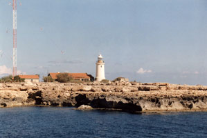
| CY 2 |
Cape Kormakiti (Cape Kormakiti, Cape Komakitis, Cape Koruçam)
latitude 35° 24' 1.6" N longitude 32° 55' 24.4" E |
Cape Koruçam is a sharp promontory on the northeast coast of Cyprus. Located on the point of the cape, about 25 km west of Lapta (Lapithos). Accessible by 4WD vehicles.
photo (N 5904) ARLHS # CYP-007 |
| CY 3 |
Girne (Kyrenia) West Mole (1907)
latitude 35° 20' 36.2" N longitude 33° 19' 11.3" E
The old harbor of Kyrenia, used now as a yacht and small boat marina, has been extended by constructing a long breakwater attached to the west mole. Located at the end of the old west mole, now an elbow of the extended mole.
Flickr
Photo courtesy Rita Willaert [Flickr] |
|
| CY 3N |
| Girne West Mole (1963)
latitude 35° 20' 34.1" N longitude 33° 19' 27" E
Located at the end of the extended breakwater of the yacht and small boat marina. Flickr
Photo courtesy Lisa Solonynko [Flickr] |
| CY 4 |
Girne Ana (Kyrenia Main) |
Girne (Kyrenia) is the principal port on the north coast of Cyprus; ferries arrive here from Alanya and Mersin on the south coast of Turkey. This light guides vessels into the ferry and commercial harbor, which is a short distance east of the old harbor. Located on a low hill just west of the ferry harbor.
(N 5901.6) |
|
|
| CY 5 |
Kyrenia Ferry Harbor South Breakwater
latitude 35° 20' 27.9" N longitude 33° 20' 4" E |
Note that while the label is "South", this really is the East Breakwater photo (N 5902.4) ARLHS # CYP-012 |
| CY 6 |
Kyrenia Ferry Harbor North Breakwater
latitude 35° 20' 31" N longitude 33° 20' 15.1" E |
(N5902.6) ARLHS # CYP-011 |
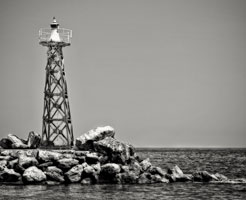
| CY 7 |
Klidhes Islands (Zafer Burnu, Cape Andreas)
latitude 35° 42' 36.9" N longitude 34° 36' 21.8" E
Zafer Burnu (Cape Andreas) is the tip of a long, sharp-pointed peninsula that projects from the northeast corner of Cyprus. The lighthouse is located on a small island off the end of the peninsula, one of several representing summits of an underwater ridge.
(N 5900) ARLHS # CYP-010
Photo courtesy Captain Peter Mosselberger [ListOfLights] |
|
|
|
| CY 8 |
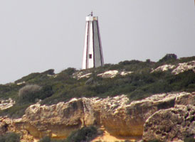
| Cape Elea (Zeytinlik Burnu)
latitude 35° 19' 28.5" N longitude 34° 2' 49.3" E
There are rumors stating that the lighthouse "will be demolished and in its place a new one will be built." Located on a promontory on the south side of the Zafer Burnu (Cape Andreas) peninsula, which projects from the northeast corner of Cyprus.
photo (N 5890) ARLHS # CYP-006
Photo courtesy Angle & Chris Pye [Flickr] |
| CY 9 |
Yeni Erenkoy Fishing Harbour |
ARLHS # CYP-013 |
| CY 10 |
Famagusta Northwest (Karakol )
latitude 35° 8' 31.2" N longitude 33° 55' 34.8" E |
This lighthouse guides vessels approaching the harbor of Mağusa (Famagusta). Located in an open area on the northwest side of the city.
(N 5893) ARLHS # CYP-008 |
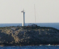
| CY 11 |
Famagusta Southeast Bastion (Canbulat, Mağusa, Gazimağusa)
latitude 35° 7' 22.6" N longitude 33° 56' 51.3" E
This is the landfall light for Mağusa (Famagusta), the principal port on the east coast of Cyprus. During medieval times, the city was one of the richest in the Middle East. Venice, which controlled the city from 1489 to 1571, fortified it with high stone walls. The lighthouse is built on the walled city's southeast bastion (the Djamboulat Bastion), adjacent to the base of the harbor.
(E 5892) ARLHS # CYP-009
Photo courtesy Alex Trabas [ListOfLights] |
|
| CY 12 |
| Cape Greco
latitude 34° 57' 25.5" N longitude 34° 5' 5.6" E
Cape Greco, the southeastern tip of Cyprus, is at the end of a long, slender peninsula. Located about 8 km southeast of Ayia Napa.
(N 5888) ARLHS # CYP-003
Photo courtesy Alex Trabas [ListOfLights] |
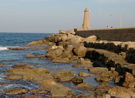
| CY 13 |
Cape Kiti
latitude 34° 49' 1.2" N longitude 33° 36' 10" E |
Located on a promontory at Kiti, about 12 km south of Larnaca.
photo (N 5882) ARLHS # CYP-004 |
| CY 14 |
Cape Gata
latitude 34° 33' 49.9" N longitude 33° 1' 27.8" E |
The lighthouse stands on the southernmost tip of Cyprus. Although it is within the British military base of Akrotiri, it is operated by the Cyprus Port Authority. Located on the point of the cape, about 8 km southeast of Akrotiri and 20 km south of the city of Limassol.
Flickr (N 5876) ARLHS # CYP-002 |
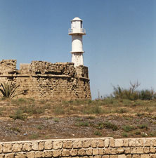
| CY 15 |
Paphos Point
latitude 34° 45' 38" N longitude 32° 24' 23.1" E
This handsome British Imperial tower is the best known and most visited lighthouse of Cyprus. Paphos is at the southwestern corner of the island, where the lighthouse served as the landfall light for ships arriving from Britain. Located on a promontory projecting into the Mediterranean at Paphos.
(E 5908) ARLHS # CYP-005
Photo courtesy Marko Forsten [Flickr] |
|
|
|
 Turkey
 Greece
