|
This page shows the documentation of the Lighthouses on inland lakes in Sweden. You can always click on the photo of the light to go to a specific (larger resolution) copy. Each lighthouse name is linked to (in our editorial opinion) the best reference site for that light. I would like to include directions on how to get to these lights. If you know such data[] could you eMail me and I'll post it here (with your choice of attribution.) mailme This list was built based on the list maintained by the Amateur Radio Lighthouse Society. My thanks to them for providing this basis for understanding. w8 |
|
| SW 372 |
Dæmman II (Kalmar Sound) |
The geographic coordinates provided suggest this light is on the north point of Djurö island. ARLHS # SWE-115 |
| SW 373 |
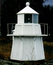
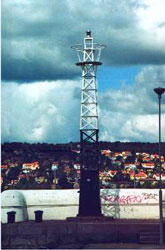
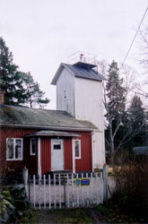
Draghællan
Located on a small island on approach to Sundsvall, southern Bothnia. ARLHS # SWE-373
Photo courtesy marinas.com [marinas.com] |
|
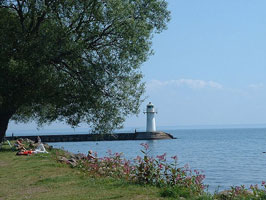
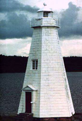
| SW 374 |
Visingø South Udde (Lake Vättern)
latitude 57° 59' 51.9" N longitude 14° 16' 36.6" E |
The island is accessible by ferry from Gränna. Located on the southwestern tip of the island. view ARLHS # SWE-423 |
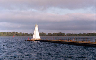
| SW 375 |
Visingø North Udde (Lake Vättern)
latitude 58° 6' 26.4" N longitude 14° 23' 47.2" E |
Located on the northeastern tip of the island. view ARLHS # SWE-422 |
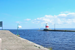
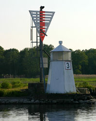
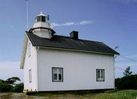
| SW 376 |
Vanæs Udde Karlsborg
latitude 58° 32' 24.6" N longitude 14° 32' 17.6" E
This light guides vessels westbound on the Göta Canal into Karlsborg. Located on a promonory on the east side of Karlsborg. Don't confuse this light with Karlsborg on Northern Coast. SW 2 ARLHS # SWE-415
Photo courtesy 'autumnal fires' [Flickr] |
|
| SW 377 |
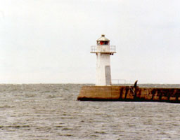
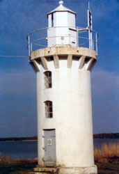
| Hjo North (Lake Vättern)
latitude 58° 18' 10.1" N longitude 14° 17' 49.3" E
Located at the north end of the detached breakwater protecting the harbor of Hjo. ARLHS # SWE-190
Photo courtesy Esbjörn Hillberg (Swedish Lighthouse Society) [fyr] |
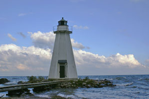
| SW 378 |
Hjo South (Lake Vättern)
latitude 58° 18' 4.3" N longitude 14° 17' 41.9" E
While it looks in this picture that the breakwater connects to the shore, it doesn't, instead it connects to the light above. ARLHS # SWE-191
Photo courtesy Jenny Mathiasson [flickr] |
|
| SW 379 |
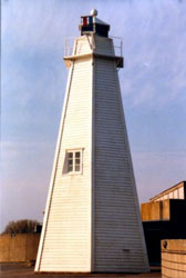
| Vadstena Pier (Lake Vättern)
latitude 58° 26' 58.8" N longitude 14° 52' 30" E
Located at the end of the mole at Vadstena. ARLHS # SWE-410
Photo courtesy © Henry Law [Flickr] |
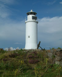
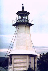
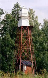
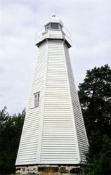
| SW 380 |
Fjuk (Lake Vättern)
This lighthouse was one of the first in Sweden to be built for automated operation. Located on a small island about 12 km west of Motala and 8 km northwest of Vadstena. ARLHS # SWE-134
Photo courtesy Patrik Lindblom [flickr] |
|
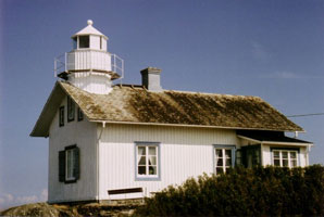
| SW 382 |
Motala |
The reference here may be to the light in Borensberg. |
| SW 383 |
Bønhamn Island |
ARLHS # SWE-103 |
| SW 384 |
Hammarö Skage (Lake Vänern)
latitude 59° 15' 15.5" N longitude 13° 30' 20.8" E
courtesy Esbjörn Hillberg (Swedish Lighthouse Society) fyr ARLHS # SWE-175 |
|
|
|
| SW 386 |
Sætersholmen (Lake Vänern) |
Note that this is described to be on Lake Vanern, but the geographic coordinates provided put it near NorrKoping. ARLHS # SWE-337 |
| SW 387 |
Jonkøping (Lake Vänern)
This appears to be right on the end of the breakwater in the village harbor. ARLHS # SWE-206
Photo courtesy Esbjörn Hillberg (Swedish Lighthouse Society) [fyr] |
|
| SW 388 |
| Hæstholmen (Lake Vänern) ARLHS # SWE-186
Photo courtesy Esbjörn Hillberg (Swedish Lighthouse Society) [fyr] |
| SW 389 |
Gælleudde (Lake Vänern)
The station is located on a promontory on the west side of the lake about 9 km northwest of the Trollhätte Canal at Vänersborg. ARLHS # SWE-143
Photo courtesy Esbjörn Hillberg (Swedish Lighthouse Society) [fyr] |
|
| SW 390 |
| Sjotorp Upper (Lake Vänern)
latitude 58° 50' 12.7" N longitude 13° 58' 27.4" E
The range guides vessels approaching the western entrance to the Göta Canal. Located on the north side of the Göta Canal entrance in Sjötorp. ARLHS # SWE-441
Photo courtesy Esbjörn Hillberg (Swedish Lighthouse Society) [fyr] |
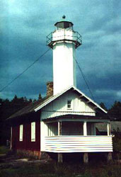
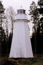
| SW 391 |
Stavik (Lake Vänern)
latitude 59° 10' 11.4" N longitude 13° 9' 32.7" E
In 2003, the lighthouse was restored and the original wood paneling was returned. The tower had been covered with concrete tiles for over 50 years. Overnight accomodations are available. The light is located about 20 km northwest of Säffle. ARLHS # SWE-367
Photo courtesy Esbjörn Hillberg (Swedish Lighthouse Society) [fyr] |
|
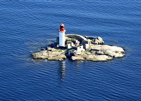
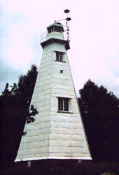
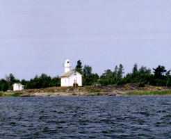
| SW 392 |
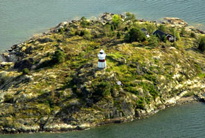
Djurö (Lake Vänern)
latitude 58° 52' 23.9" N longitude 13° 28' 19.6" E |
Djurö, an island near the center of the lake, has been a national park since 1991. Located at the northeastern point of the island. The island is accessible only by boat; a hiking trail leads to the lighthouse. |
| SW 393 |
Lidkøping Pier (Lake Vänern)
latitude 58° 30' 53.3" N longitude 13° 10' 14.4" E
Located at the end of the breakwater mole of Lidköping. ARLHS # SWE-237
Photo courtesy xjy [Flickr] |
|
| SW 394 |
| Naven (Lake Vänern)
latitude 58° 42' 4.7" N longitude 13° 6' 32.8" E
Located on a small island off the northwest side of Kållandsö, a large island barely separated from the mainland, about 15 km north northwest of Lidköping. ARLHS # SWE-287
Photo courtesy Esbjörn Hillberg (Swedish Lighthouse Society) [fyr] |
| SW 395 |
Hjortens Udde (Lake Vänern)
This is one of the oldest lighthouses designed by Heidenstam. It remains in service, although the offshore Hjortgrundet Fyr may be more important for navigation now.
Located on a prominent cape on the west side of the lake about 12 km east southeast of Mellerud. ARLHS # SWE-192
Photo courtesy Esbjörn Hillberg (Swedish Lighthouse Society) [fyr] |
|
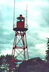
| SW 396 |
| Mariestad (Lake Vänern)
latitude 58° 42' 59.2" N longitude 13° 48' 59.9" E
Clearly the "old" light is directly in front of the "new" and active light. (C 6797.721) ARLHS # SWE-273
Photo courtesy Alex Trabas [ListOfLights] |
|
|
| SW 397 |
Snuggen (Lake Vänern)
latitude 58° 43' 25" N longitude 13° 50' 51.3" E
This light is the rear light of a range with the Snappudden Nedre light as the front light. Located just off the lakeshore road on the north side of Mariestad. ARLHS # SWE-359
Photo courtesy Esbjörn Hillberg (Swedish Lighthouse Society) [fyr] |
|
| SW 398f |

| Snappudden Nedre (Lake Vänern)
latitude 58° 44' 28.1" N longitude 13° 50' 29.1" E
This light is off the northeastern end of a skerry about 1.5 km southwest of the rear light (C 6797.698)
Photo courtesy Alex Trabas [ListOfLights] |
| SW 398 |
Snappudden Övre (Lake Vänern)
latitude 58° 44' 40.5" N longitude 13° 51' 50.4" E ARLHS # SWE-356
Photo courtesy Esbjörn Hillberg (Swedish Lighthouse Society) [fyr] |
|
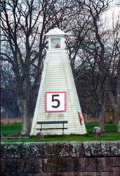
| SW 399 |
| Nolhagen (Lake Vänern)
Located on the lakeshore about 2 km northeast of Mariestad. The photo is marked as a "front range". This Rear Range has been relocated to the middle of the Göteborgsrondellen, a traffic roundabout in Mariestad at the intersection of Göteborgsvägen and Marieforsleden. ARLHS # SWE-291
Photo courtesy Esbjörn Hillberg (Swedish Lighthouse Society) [fyr] |
| SW 400 |
Megrundet (Lake Vänern) |
ARLHS # SWE-279 |
| SW 401 |
Palgrunden (Lake Vänern) |
ARLHS # SWE-310 |
| SW 402 |
Runnen (Lake Vänern) |
ARLHS # SWE-331 |
| SW 403 |
Stångudden (Lake Vänern)
Located on the small island of Lurö off the southern tip of the Värmlandsnäs peninsula and about 8 km northeast of the Pålgrunden lighthouse. ARLHS # SWE-366
Photo courtesy Esbjörn Hillberg (Swedish Lighthouse Society) [fyr] |
|
| SW 404 |
| Smørhættan (Lake Vänern)
latitude 58° 47' 57.7" N longitude 13° 41' 52.8" E
Located at the southern tip of Brommö. Accessible by road ARLHS # SWE-354
Photo courtesy Esbjörn Hillberg (Swedish Lighthouse Society) [fyr] |
| SW 405 |
Harnæsudde (Lake Vänern) ARLHS # SWE-181
Photo courtesy Esbjörn Hillberg (Swedish Lighthouse Society) [fyr] |
|
| SW 406 |
Gunnarsholmen (Lake Vänern)
Located on an small island off the southwestern side of the Värmlandsnäs peninsula about 5 km northwest of the Stångudden lighthouse ARLHS # SWE-164
Photo courtesy Esbjörn Hillberg (Swedish Lighthouse Society) [fyr] |
|
| SW 407 |
Stora Klubbens (Lake Vänern) |
Located on an small island just off the southern tip of the Värmlandsnäs peninsula about 6 km (3.5 mi) north of the Stångudden lighthouse. ARLHS # SWE-372
Photo courtesy www.fyr.org/images/939200LH01.jpg |
| SW 408 |
Lakholmen
latitude 59° 11' 15.8" N longitude 14° 30.7" E |
Located about 2.5 km west of Brattsand. ARLHS # SWE-230 |
| SW 409 |
Åsnegrundet |
ARLHS # SWE-087 |
| SW 410 |
Strandsudde ARLHS # SWE-377
Photo courtesy Esbjörn Hillberg (Swedish Lighthouse Society) [fyr] |
|
| SW 411 |
| Risnæsudde
latitude 59° 17' 26.1" N longitude 13° 9' 34.9" E
Located on a point of land on the west side of the entrance to the arm of the lake leading to Grums, about 5 km south southeast of the town. ARLHS # SWE-322
Photo courtesy Esbjörn Hillberg (Swedish Lighthouse Society) [fyr] |
| SW 412 |
Søøkojan
latitude 59° 18' 4.8" N longitude 13° 39' 38.6" E |
Located on an island in the northeastern corner of the lake view ARLHS # SWE-360
Photo courtesy about 3 km east of Rud. |
| SW 413 |
Skoghall
The original light,the first light built on the lake, was replaced in 1855. Located on the tip of a peninsula at the entrance to the harbor of Skoghall, on the west side of Hammarö. ARLHS # SWE-348
Photo courtesy Esbjörn Hillberg (Swedish Lighthouse Society) [fyr] |
|
| SW 414 |
Ønskåsskærets
latitude 59° 20' 1.8" N longitude 13° 9' 1.8" E |
ARLHS # SWE-301 |
| SW 416 |
Fællholmen
latitude 58° 53' 39.8" N longitude 13° 53' 21.6" E |
The light was formerly the front light of a range, and we do not know if the rear lighthouse survives. Located on a small island about 5 km northwest of Sjötorp ARLHS # SWE-127 |
| SW 417 |
Fogden
latitude 59° 1' 52.4" N longitude 12° 44' 17.8" E
On a small island, the light appears to be at the high point, but the keepers house is some distance away in a sheltered valley. ARLHS # SWE-140
Photo courtesy marinas.com [marinas.com] |
|
|
|