|
This page shows the documentation of the Lighthouses of Southern Sweden. You can always click on the photo of the light to go to a specific (larger resolution) copy. Each lighthouse name is linked to (in our editorial opinion) the best reference site for that light. I would like to include directions on how to get to these lights. If you know such data, could you eMail me and I'll post it here (with your choice of attribution.) me This list was built based on the list maintained by the Amateur Radio Lighthouse Society. My thanks to them for providing this basis for understanding. w8 |
|
Blekinge Län
| SW 204 |
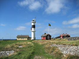
Utlængen
latitude 56° 48.6" N longitude 15° 47' 18.3" E |
The light is located at the southern tip of Utlængen island. ARLHS # SWE-406 |
| SW 205 |
Fløtjen
latitude 56° 2' 30.9" N longitude 15° 46' E |
Located on an island about 3.5 miles SW of Torhamn, SE coast of Sweden. ARLHS # SWE-139 |
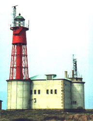
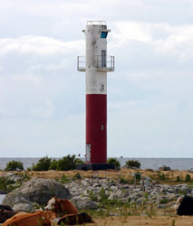
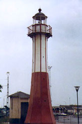
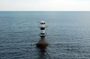
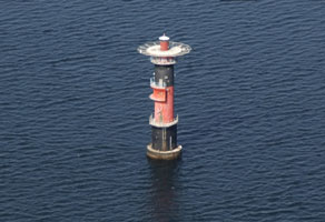
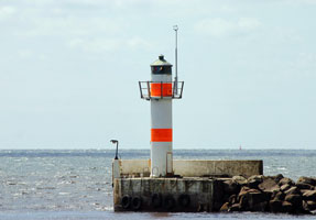
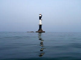
| SW 206 |
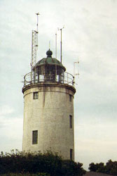
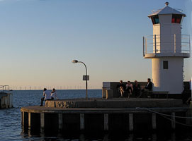
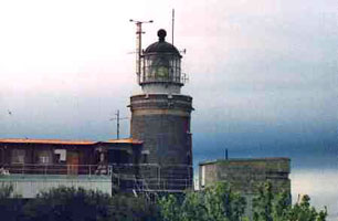
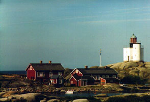
Utklippan
latitude 55° 57' 10" N longitude 15° 42' 6" E
Located on a small island about 10 miles SE of Karlskrona. As you can see, the tower is a red cast-iron skeletal and mounted on a fort. (C 7442) ARLHS # SWE-072
Photo courtesy Esbjörn Hillberg (Swedish Lighthouse Society) [fyr] |
|
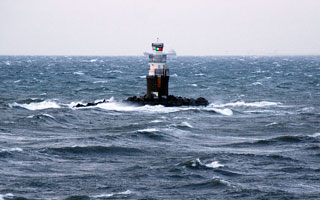
| SW 207 |
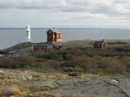
Utklippan II |
ARLHS # SWE-073 |
| SW 208 |
Laboratorieholmen
Located at the NE tip of island of Stumholmen, SE coast of Sweden. photo (C 7462) ARLHS # SWE-228
Photo courtesy Alex Trabas [ListOfLights] |
|
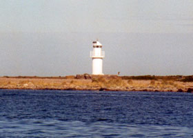
| SW 209 |
| Rønneskær
Located on a small island about ½ mile southeast of the waterfront of Kuggeboda. ARLHS # SWE-328
Photo courtesy Alex Trabas [liteslist] |
| SW 210 |
Gåsfeten |
Located on Gåsfeten, an islet about 6 km southwest of the Rönneby Hamn waterfront. photo ARLHS # SWE-146 |
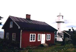
| SW 211 |
Viskær
latitude 58° 29' 18.9" N longitude 16° 59' 27.3" E
Deactivated in 1887, it was relocated in 1890 to Storkläppen, an island in Kalmar. However, that station was devastated by a storm in November of the same year. The tower survived, and in 1894 it was relocated a second time to Viskär. The house is now a private residence, and the owners have maintained the lighthouse in excellent condition. Located on an island about 2.5 km east of Arkösund. ARLHS # SWE-324
Photo courtesy Esbjörn Hillberg (Swedish Lighthouse Society) [fyr] |
|
| SW 212 |
Tärnö
latitude 56° 6' 47.6" N longitude 14° 58' 18.6" E |
Tärnö is a small island about 3 km south of Matvik and 7 km southwest of Karlshamn. The light is located on the highest point of the island.
Apparently there are 2 lights on this island, one on the South Point, the other on the East Point. (C 7514) ARLHS # SWE-389 |
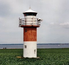
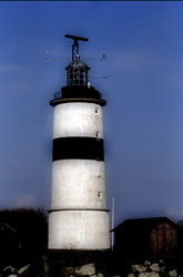
| SW 214 |
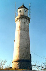
Hanö
latitude 56° 49.5" N longitude 14° 50' 46.8" E
A white cylindrical brick tower located on the island of Hanö, off SE tip of Listerlandet peninsula, south coast of Sweden. ARLHS # SWE-027
Photo courtesy Esbjörn Hillberg (Swedish Lighthouse Society) [fyr] |
|
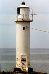
| SW 215 |
| Karlskrona
latitude 56° 9' 32.6" N longitude 14° 35' 49.7" E ARLHS # SWE-213
Photo courtesy Esbjörn Hillberg (Swedish Lighthouse Society) [fyr] |
| SW 215R |
Karlskrona Nedre rear range
Photo courtesy Esbjörn Hillberg (Swedish Lighthouse Society) [fyr] |
|
| SW 216 |
| Hællevik
latitude 56° 46.9" N longitude 14° 42' 13.3" E
Hällevik is a village about 8 km east of Sölvesborg. Located on the east side of the town. (C 7548) ARLHS # SWE-171
Photo courtesy Karl-Heinz Wellm [ListOfLights] |
| SW 217 |
Sillnæsudde
Located on the SW side of the Listerlandet peninsula. (C 7551.6) ARLHS # SWE-339
Photo courtesy Alex Trabas [ListOfLights] |
|
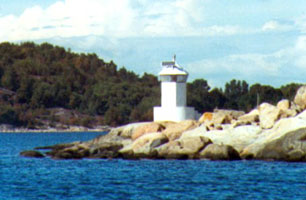
| SW 218 |
Lægerholmen |
Located on a small island about 3 km offshore and about 6 km southwest of Tredenborg; the island is a nature reserve. photo ARLHS # SWE-229 |
Skåne Län
| SW 219 |
Simrishamn
Located on the waterfront of Simrishamn. (C 7582) ARLHS # SWE-341
Photo courtesy Esbjörn Hillberg (Swedish Lighthouse Society) [fyr] |
|
| SW 220 |
| Stenshuvud
Located on a cape about 8 km northwest of Simrishamn. ARLHS # SWE-369
Photo courtesy bjaglin [Flickr] |
| SW 221 |
Sandhammaren
A red cast iron pyramidal skeletal tower located at the SE corner of the Skane province. (C 2460) ARLHS # SWE-055
Photo courtesy Esbjörn Hillberg (Swedish Lighthouse Society) [fyr] |
|
|
|
| SW 222 |
| Ystad
latitude 55° 25' 36.9" N longitude 13° 49' 32.5" E
Ystad is the terminal for ferries to the Danish island of Bornholm and to Swinoujscie, Poland. The lighthouse is located on the traditional waterfront near the ferry terminal. ARLHS # SWE-077
Photo courtesy Esbjörn Hillberg (Swedish Lighthouse Society) [fyr] |
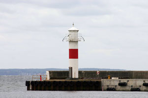
| SW 222E |
Ystad East Breakwater
latitude 55° 25' 0.2" N longitude 13° 49' 6" E
Located at the end of the east breakwater of Ystad. (C 2450.5)
Photo courtesy Johan Känngård [Flickr] |
|
| SW 223 |
Smygehuk
latitude 55° 20' 18" N longitude 13° 21' 9.4" E
Located on the coastal highway about 1.5 km west of Smygehamn. (C 2439) ARLHS # SWE-355
Photo courtesy Esbjörn Hillberg (Swedish Lighthouse Society) [fyr] |
|
| SW 224 |
| Kullagrundet
This is the southernmost Swedish lighthouse. Located in the Baltic about 3 km offshore from Smygehuk and 12 km southeast of Trelleborg. (C 2445) ARLHS # SWE-036
Photo courtesy Alex Trabas [ListOfLights] |
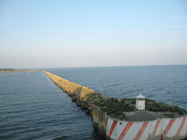
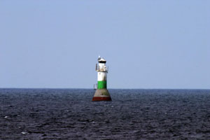
| SW 225 |
Trelleborg
This the oldest of many caisson lighthouses built to replace lightship stations on Sweden's coast. Located about 1.6 km south of the entrance to Trelleborg harbor. ARLHS # SWE-069
Photo courtesy Christoph Müller [Flickr] |
|
| SW 226 |
| Malmø Vågbrytarbank
latitude 55° 37' 29.5" N longitude 12° 58' 34.2" E
Located on a notorious rocky shoal just off the entrance to Malmö harbor, about 300 m west of the north breakwater. (C 2358) ARLHS # SWE-272
Photo courtesy Olof Adell [Flickr] |
| SW 230 |
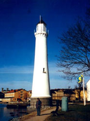
Malmö
latitude 55° 36' 32.4" N longitude 12° 59' 47.9" E
The light is now located on the Citadellsvågen at the intersection of the Hjälmarekajen quay. ARLHS # SWE-045
Photo courtesy Izaeus Argazk [Flickr] |
|
| SW 227 |
Limhamn |
ARLHS # SWE-261 |
Hallands Län
| SW 228 |
Lernacken
latitude 55° 34' 13.5" N longitude 12° 53' 54.6" E
This lighthouse is located a short distance north of the eastern end of the Oresund Bridge-Tunnel (E-20); it became obsolete after that crossing was completed in 1999. ARLHS # SWE-474
Photo courtesy P1r [Flickr] |
|
| SW 229 |
| Pinhætten
Located in the Oresund about 2.5 km west of Barsebäckshamn. (C 2336) ARLHS # SWE-314
Photo courtesy Alex Trabas [ListOfLights] |
| SW 232 |
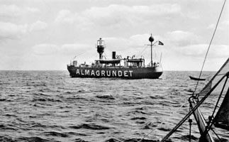
Lightship Almagrundet
latitude 59° 36' 9.8" N longitude 16° 33' 5.5" E
This boat served at this station from 1896-1912. At this time, the lightship is in very good condition and can be found at the Tullhus Pier in the inner harbour of Västerås in Sweden. ARLHS # SWE-239
Photo courtesy anonymous [wikipedia] |
|
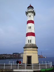
| SW 233 |
| Falsterbo
latitude 55° 23' 1.4" N longitude 12° 48' 59" E
This is the oldest light in Sweden and is located at the Southernmost point in Sweden. It currently is on a golf course in an area well known for bird watching. (C 2416) ARLHS # SWE-008
Photo courtesy Esbjörn Hillberg (Swedish Lighthouse Society) [fyr] |
| SW 233R |
Falsterborev
This light protects boats from the reef ("rev") just off Falsterbo. It is the tallest light in Sweden and is located in the middle of the southern entrance to the Oresund, about 12 km southwest of Falsterbo and the same distance east of Stevns Klint, Denmark. (C 2417)
Photo courtesy Alex Trabas [ListOfLights] |
|
| SW 234 |
| Skanør
latitude 55° 25' 1.1" N longitude 12° 49' 40.8" E
Located on the north breakwater of Skanör, a small port about 2.5 km north of Falsterbo. ARLHS # SWE-345
Photo courtesy Olga [Flickr] |
| SW 235 |
Høllviken
Located in the Oresund about 3 km west of Höllviken, an artificial harbor south of Malmö. (C 2408) ARLHS # SWE-197
Photo courtesy Alex Trabas [ListOfLights] |
|
|
|
| SW 236 |
| Vens Södra Udde
latitude 55° 53' 31.3" N longitude 12° 42' 40.6" E
Located in an open field near the southeastern end of the island, about 1 km southwest of Bäckviken. (C 1932) ARLHS # SWE-334
Photo courtesy Karl-Heinz Wellm [ListOfLights] |
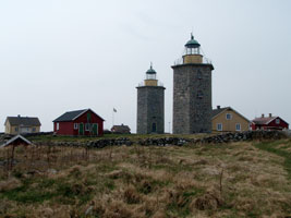
| SW 237 |
Haken (Ven Island)
latitude 55° 54' 33.6" N longitude 12° 43' 28.2" E (C 1936) ARLHS # SWE-168
Photo courtesy Esbjörn Hillberg (Swedish Lighthouse Society) [fyr] |
|
| SW 238 |
| Ven Island
latitude 55° 54' 52.6" N longitude 12° 40' 6.3" E
Located at the end of the Fyrvägen near the northwestern tip of the island about 600 m northwest of Kyrkbacken. (C 1928) ARLHS # SWE-034
Photo courtesy Karl-Heinz Wellm [ListOfLights] |
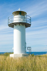
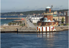
| SW 239 |
Helsingborg
latitude 56° 2' 35.7" N longitude 12° 41' 16.2" E
This lovely and historic lighthouse welcomes travelers arriving in Helsingborg on Scandlines ferries from Helsingør, Denmark. Located at the south end of the main north mole at Helsingborg. ferry (C 2288) ARLHS # SWE-029
Photo courtesy Gloria Stevenson [Flickr] |
|
| SW 240 |
| Svinbådan Fyr
A sibling of the Tylögrund lighthouse, this tower is located on a shoal in the Oresund about 1.5 km off the coast at Viken. (C 2274) ARLHS # SWE-067
Photo courtesy Marinas.com [marinas.com] |
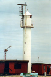
| SW 241 |
Hoøganæs Pier
latitude 56° 11' 47.9" N longitude 12° 32' 32.8" E
Located at the end of the breakwater mole at Högenäs. (C 2268) ARLHS # SWE-193
Photo courtesy Alex Trabas [ListOfLights] |
|
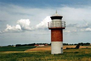
| SW 242 |
| Kullen
latitude 56° 18' 3.4" N longitude 12° 27' 5.9" E
This is the most powerful light in Scandanavia. It is located at the mouth of Oresund River, Kullaberg Peninsula, west coast of Sweden. ARLHS # SWE-037
Photo courtesy Esbjörn Hillberg (Swedish Lighthouse Society) [fyr] |
| SW 243 |
Hallands Väderö
latitude 56° 27' 2.4" N longitude 12° 32' 33.3" E
Hallands Väderö is an uninhabited island in the Kattegat about 2.5 km in length and about 2.5 km off the end of the Bjare Peninsula. Passenger ferry transportation is available from Torekov. Located at the western tip of the island; accessible by easy hiking trails. (C 2242) ARLHS # SWE-170
Photo courtesy Esbjörn Hillberg (Swedish Lighthouse Society) [fyr] |
|
| SW 244 |
| Tylön
latitude 56° 38' 47.6" N longitude 12° 42' 34.1" E
Tylön is an unoccupied island just off a cape at Tylösand, about 10 km west of Halmstad. It is now a bird sanctuary. ARLHS # SWE-399
Photo courtesy Sofia Nilsson [Flickr] |
| SW 245 |
Halmstad
latitude 56° 38' 54.9" N longitude 12° 50' 10.2" E
Located at the end of the long breakwater of Halmstad. (C 0738)
Photo courtesy Esbjörn Hillberg (Swedish Lighthouse Society) [fyr] |
|
| SW 246 |
| Falkenberg
Located at the end of the main breakwater at Flakenhamn. (C 0722)
Photo courtesy Alex Trabas [ListOfLights] |
| SW 248 |
Tyløgrund |
ARLHS # SWE-398 |
| SW 249 |
Løvstaviken
latitude 56° 52' 55.7" N longitude 12° 27' 57.2" E |
ARLHS # SWE-269 |
| SW 250 |
Morups Tånge
Morups Tånge is a low peninsula projecting into the Kattegat about 8 km west of Falkenberg. (C 0716) ARLHS # SWE-048
Photo courtesy Sune Frack [Flickr] |
|
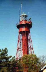
| SW 251 |
| Subbeberget (Varberg)
latitude 57° 5' 17.4" N longitude 12° 14' 12.9" E
Located on a promontory at the south side of the entrance to Varberg. (C 0704) ARLHS # SWE-381
Photo courtesy Esbjörn Hillberg (Swedish Lighthouse Society) [fyr] |
| SW 252 |
Varberg |
Located on an island in the entrance to Varberg harbor, about 1.5 km northwest of the Subbeberget Fyr. ARLHS # SWE-418 |
| SW 253 |
Varberg West Pier |
Data implies this is a lost lighthouse. ARLHS # SWE-419 |
| SW 254 |
Fladen |
This tower, a sibling of the Trubaduren lighthouse off Göteborg, replaced the lightship Fladen now on display at Göteborg. Located on a shoal in the open Kattegat about 6 miles south southwest of Nidingen. ARLHS # SWE-135 |
| SW 255 |
Nidingen
latitude 57° 18' 9.8" N longitude 11° 54' 2.8" E
Transportation for both day and overnight visitors is available from Gottskär on the mainland. Located in the Kattegat about 6 miles southwest of Gottskär. (C 0670) ARLHS # SWE-288
Photo courtesy Jonas Karlsson [Flickr] |
|
| SW 256 |
Nidingen II
latitude 57° 18' 10.1" N longitude 11° 54' 6.3" E |
(see above) ARLHS # SWE-428 |
| SW 257 |
Nidingen III
latitude 57° 18' 10.8" N longitude 11° 54' 7.7" E |
(see above) ARLHS # SWE-289 |
| SW 258 |
Nidingen Newest Light ARLHS # SWE-290
Photo courtesy Jonas Karlsson [Flickr] |
|
| SW 259 |
| Lilleland (C 0666) ARLHS # SWE-258
Photo courtesy Jonas Karlsson [Flickr] |
| SW 260 |
Malö ARLHS # SWE-446
Photo courtesy Esbjörn Hillberg (Swedish Lighthouse Society) [fyr] |
|
| SW 261 |
| Malö Hamn Skalla ARLHS # SWE-443
Photo courtesy Esbjörn Hillberg (Swedish Lighthouse Society) [fyr] |
| SW 262 |
Fjordskær |
ARLHS # SWE-133 |
| SW 263 |
Hallands Svartskær |
(C 0660) ARLHS # SWE-169 |
| SW 265 |
| Tistlarna
Located on a small island in the Kattegat about 6 km southwest of Vrångö. (C 0625) ARLHS # SWE-392
Photo courtesy Esbjörn Hillberg (Swedish Lighthouse Society) [fyr] |
| SW 266 |
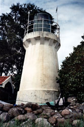
Valö
This lighthouse is important in guiding ships approaching Göteborg from the south. Located at the southeastern point of Valö. (C 0628) ARLHS # SWE-413
Photo courtesy erik [www.kajak.nu] |
|
|
|
 Southeastern Sweden

