|
This page currently my understanding of the lights of Maine. Downloadable copies of this pictures are stored on the web (mostly Webshots or Flickr). The pictures below are active, if you press on one, you'll be directly connected to the site with that picture (or one very similar) at a much higher resolution. Index numbers are from the Shanklin List of all US lights. p2 |
|
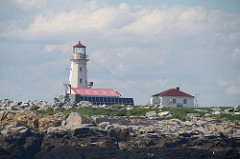
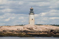
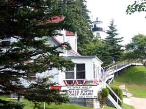
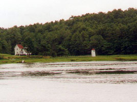
| NB 35 |
Mulholland Lighthouse
latitude 44° 51' 47" N longitude 66° 58' 44.4" W
July 20, 2004 access: car
Located on the east side of the Lubec Channel (thus in Canada), this lighthouse can easily be seen from Maine (if the fog's not in). It was pretty thick when I got up, but after breakfast, as you can see, the other side was visible (if not beautifully lit).
(Take US 1 as far east as it will go, the follow State route 189 to Lubec. God willing, you will see both this light and the one below. ME2 |
|
| ME 1 |
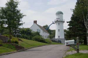
| Whitlocks Mill
latitude 45° 9' 43.2" N longitude 67° 13' 24.5" W
July 10, 2008 access: view from car park
This is the northernmost light in New England (but south of many in the Great Lakes).
It can be seen distantly from the first roadside picnic area on Route 1 south of St. Stephan NB. ARLHS # USA-890 |
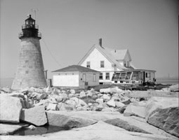
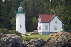
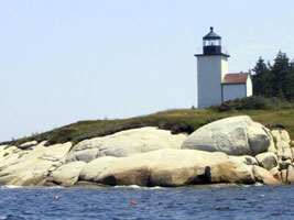
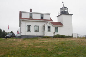
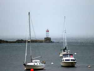
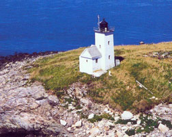
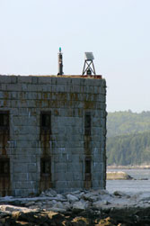
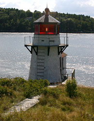
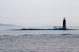
| ME 2 |
Lubec Channel
latitude 44° 50' 31.3" N longitude 66° 58' 36.3" W
July 20, 2004 access: view from shore, boat
Yes, Lubec Maine is related to Lubeck, Germany (the first settlers came from there). This cast iron tower on a steel caisson was one of 47 of this design, all called "sparkplug" lighthouses. It was built in 1890, was automated in 1939, but is no longer in service. ARLHS # USA-459 |
|
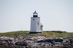
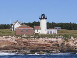
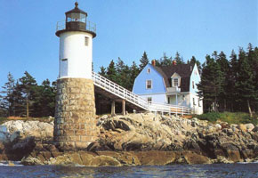
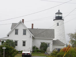
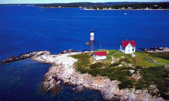
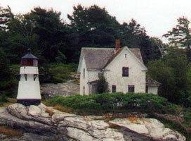
| ME 3 |
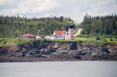
| West Quoddy Head
July 20, 2004 access: car
With it's pretty red and white candy strips, this is one of the more famous in Maine. It's also the eastern most light in the US. Constructed in 1858, it was automated in 1988.
Take US 1 as far east as it will go, then follow State route 189 to Lubec. Just before town, follow the signs to the state park. ARLHS # USA-880 |
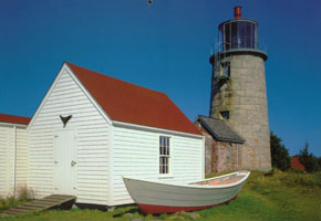
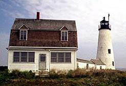
| ME 4 |
Little River
latitude 44° 39' 2.8" N longitude 67° 11' 32.1" W
July 30, 2016 access: boat
Little River Island, Cutler Harbor.
Overnight Stays are possible. Volunteers will meet you at the public boat ramp and take you on the 12 minute boat ride to the light. reservations ARLHS # USA-442 |
|
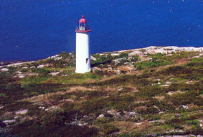
| ME 5 |
| Machias Seal (Canadian maintained)
latitude 44° 30' 6.6" N longitude 67° 6' 6.8" W
July 30, 2016 access: boat
The island can be visited on Puffin Trips offered by Bold Coast Charters out of Cutler. bold (J 0024) ARLHS # CAN-918 |
| ME 6 |
Libby Island
latitude 44° 34' 5.6" N longitude 67° 22' 2.6" W
July 30, 2016 access: boat
Machias Bay Boat Tours are available, which pass by Libby Island. tours ARLHS # USA-432 |
|
| ME 6A |
Moosabec Reach |
Reported in 1911 to be on the Northerly side of E'ly entrance to Moosabec River. |
| ME 7 |
Moose Peak (Mistake Island)
latitude 44° 28' 27.8" N longitude 67° 31' 55.8" W
July 30, 2016 access: boat
Captain Laura Fish, (207) 497-3064, offers tours to Great Wass Island and Mistake Island. Captain John Norton (207-497-5933) offers boat tours to Machias Seal Island, which for an extra fee, will pass by Mistake Island. ARLHS # USA-513 |
|
| ME 8 |
| Nash Island
latitude 44° 27' 51.4" N longitude 67° 44' 50.2" W
July 30, 2016 access: boat
Robertson Sea Tours offers Lighthouse Tours that pass by the island. tours ARLHS # USA-527 |
| ME 9 |
Narraguagus (Pond Island)
latitude 44° 27' 21.5" N longitude 67° 49' 52.4" W
July 30, 2016 access: boat
Robertson Sea Tours offers a Lighthouse Tour that passes by the island. tours ARLHS # USA-526 |
|
| ME 10 |
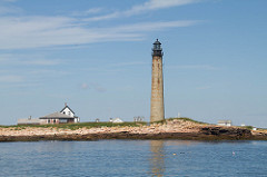
| Petit Manan
latitude 44° 22' 3.1" N longitude 67° 51' 50.8" W
July 30, 2016 access: boat
Robertson Sea Tours offers a Lighthouse Tour that passes by the island. tours ARLHS # USA-597 |
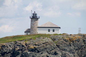
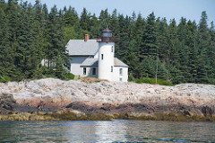
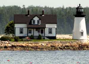
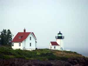
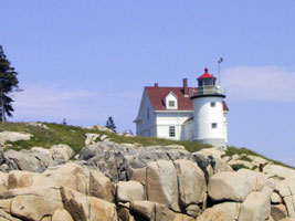
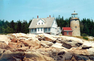
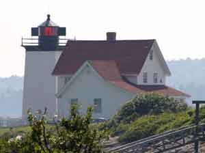
| ME 11 |
Prospect Harbor Point
latitude 44° 24' 11.5" N longitude 68° 46" W
July 20, 2004 access: view from shore, boat
The light is actually located on a Naval Base, and restricted from access. However, if you go to the village of Prospect Harbor, and take your binoculars, you can see the picture we've attached. (J 0038) ARLHS # USA-674 |
|
| ME 12 |
| Winter Harbor (Mark Island)
latitude 44° 21' 41.2" N longitude 68° 5' 15.6" W
July 30, 2016 access: view from shore, boat
It can be seen distantly from the roadside on the Schoodic Peninsula. (J 0294) ARLHS # USA-900 |
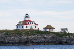
| ME 13 |
Egg Rock
latitude 44° 21' 14.4" N longitude 68° 8' 16.5" W
July 30, 2016 access: boat
Located in Frenchman Bay, it is best viewed by boat. Views from the shore are possible, but it is a long way out. (J 0040) ARLHS # USA-268 |
|
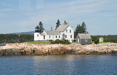
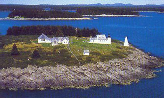
| ME 14 |
| Bear Island
latitude 44° 17' 0.7" N longitude 68° 16' 11.2" W
access: boat
Near Northeast Harbor, ME (J 0045) ARLHS # USA-045
Photo courtesy National Park Service [wikipedia] |
| ME 15 |
Baker Island
latitude 44° 14' 28.6" N longitude 68° 11' 56" W |
The Bar Harbor Whale Watch Company offers a tour. tour ARLHS # USA-028 |
| ME 17 |
| Great Duck Island
latitude 44° 8' 31.7" N longitude 68° 14' 44.9" W
July 30, 2016 access: boat
Historic Lighthouse Tour offered by Bar Harbor Whale Watch. ARLHS # USA-347
Photo courtesy paflyfisher [Webshots] |
|
|
| ME 18 |
Bass Harbor
latitude 44° 13' 19" N longitude 68° 20' 14.1" W
July 20, 2004 access: car
Reputedly, the most photographed lighthouse in Maine (so they say, I'd suspect Portland Head wins hands down), this is just south of the town of Bass Harbor, and easy to find. There is a little matter of the walk down the stairs (down was easy, up wasn't), but we won't mention the small details (much). (J 0054) ARLHS # USA-041 |
|
| ME 19 |
| Blue Hill Bay
latitude 44° 14' 56.3" N longitude 68° 29' 53.5" W
access: boat
Blue Hill Bay Lighthouse is located on Green Island, on the west side of the bay for which the light station is named. ARLHS # USA-064
Photo courtesy whitecloud00 [Webshots] |
| ME 20 |
Burnt Coat Harbor /Hockamock Head
latitude 44° 8' 2.8" N longitude 68° 26' 49.7" W
access: ferry with your car
Located on Hackamock Head
Ferry from Bass Harbor to Swan's Island. Exit the ferry and turn right to the stop sign (1/2 mile). Turn right and drive nearly 4 miles to the lighthouse. (J 0058) ARLHS # USA-096
Photo courtesy whitecloud00 [Webshots] |
|
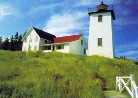
| ME 22 |
Isle Au Haut (Robinson Point)
access: Car
A bed and breakfast ARLHS # USA-404
Photo courtesy whitecloud [Webshots] |
|
| ME 23 |
| Deer Island (Mark Island)
latitude 44° 8' 3.8" N longitude 68° 42' 12.4" W
access: boat
Best seen from a boat (J 0073) ARLHS # USA-221
Photo courtesy pats7288 [Webshots] |
| ME 24 |
Eagle Island
latitude 44° 13' 3" N longitude 68° 46' 3.7" W
access: boat
Near Deer Isle, ME
Excursion trips around the islands are offered via the Eagle Island Mail Boat from Sunset, Maine. The boat will pass by the Eagle Island Lighthouse en route to delivering mail to several islands in the area (J 0078) ARLHS # USA-256
Photo courtesy L. Stratton (Eastern Illustrating) [ListOfLights] |
|
| ME 25 |
| Pumpkin Island
latitude 44° 18' 33.1" N longitude 68° 44' 34.4" W
August 19, 2017 access: car
Turn right on Eggemoggin Road just after crossing the bridge to Little Deer Isle and drive all the way to the end of the road. Step out on the point and there it is! ARLHS # USA-677 |
| ME 26 |
Dice Head
latitude 44° 22' 58.2" N longitude 68° 49' 8.4" W
August 19, 2017 access: car
Private residence near Castine, ME
From Highway 1 near Orland, turn south on Highway 175 and drive south for eight miles to West Penobscot. From there, continue south on Highway 166 for roughly seven miles to Castine. In Castine, follow Battle Avenue past the Maine Maritime Academy to its end. (J 0082) ARLHS # USA-231 |
|
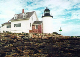
| ME 27 |
| Fort Point
latitude 44° 28' 2" N longitude 68° 48' 42.1" W
August 19, 2017 access: car
A state historic site located on the west side of the mouth of the Penobscot River in Cape Jellison near Searsport.
From Highway 1 near Stockton Springs, take Main Street into the town and then turn south on Cape Jellison Road. When the road splits after 0.8 miles, take the left fork and continue for 1.6 miles to the park entrance. The road just past the park entrance (Lighthouse Road) will take you directly to the lighthouse (J 0086) ARLHS # USA-296 |
| ME 28 |
Grindle Point
latitude 44° 16' 53.1" N longitude 68° 56' 34.2" W
access: ferry
Ferry from Lincolnville Beach (about 6 miles north of Camden) ARLHS # USA-356
Photo courtesy whitecloud [Webshots] |
|
| ME 29 |
| Curtis Island
latitude 44° 12' 4.5" N longitude 69° 2' 56.9" W
July 20, 2004 access: car, then view
As we went to dinner, we got a map (to find the restaurant). Marnie asked "do you suppose we can see the Curtis Island light from near the restaurant?" Well, not close, and not from public land, but we found an unoccupied house, walked on their ground, and look what I found! This is a public park, but access is by boat.
Curtis Island is just south of Camden ME. Find one, the other is easy to find (but the light is not necessarily visible) (J 0096) ARLHS # USA-213 |
| ME 29B |
Camden Breakwater
latitude 44° 12' 29.7" N longitude 69° 3' 38.6" W
July 20, 2004 access: car, then view
On the way to get the picture of the Curtis Island Light (see above), we thought we'd found it. Here's the picture we got (and then compared with the reference book and found we were wrong.) |
|
| ME 30 |
| Goose Rocks
access: boat
Access is by boat ARLHS # USA -326
Photo courtesy queenbgeorge [Webshots] |
| ME 31 |
Indian Island (Beauchamp Point/Lowell Rock)
latitude 44° 9' 55" N longitude 69° 3' 39.8" W
access: car + view
Can be seen from Rockport Marine Park ARLHS # USA-400
Photo courtesy whitecloud [Webshots] |
|
| ME 32 |
| Browns Head
access: boat
Vinalhaven, ME (private residence) ARLHS # USA-088
Photo courtesy whitecloud [Webshots] |
| ME 33 |
Heron Neck
access: boat
View by boat ARLHS # USA-371
Photo courtesy pats7288 [Webshots] |
|
| ME 34 |
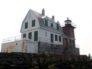
| Rockland Breakwater
latitude 44° 6' 14.7" N longitude 69° 4' 39.1" W
July 21, 2004 access: walk (1 mile)
We got our exercise early this morning as we walked the "more than a mile" out the breakwater to this light. As you can see, it's a lovely light, but it also was 1 hour round trip from the car. (J 0102) ARLHS # USA-699 |
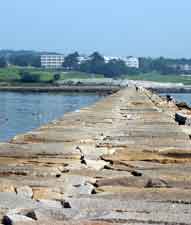
| ME 34B |
View of the Breakwater
access: car
This is the view of the breakwater when you are standing at the light. I'm sure you won't believe me about the length, so I attached this photo. |
|
|
|
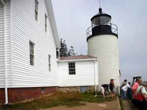
| ME 34H |
| Rockland Harbor Southwest
access: boat
(J 0102)
Photo courtesy Alex Trabas [ListOfLights] |
| ME 35 |
Owls Head
latitude 44° 5' 31.6" N longitude 69° 2' 38.7" W
July 21, 2004 access: car
All the way on the other side of the bay from the Rockland Breakwater is this light. It was built in 1826 and is still in operation. We're told that the fog signal is more important than the light (because when it's really important, you can't see the light).
From Rockland, take route 73 south, then turn left on North Shore Road. The left turn into the light is well marked. (J 0104) ARLHS # USA-574 |
|
| ME 36 |
| Two Bush Island
latitude 43° 57' 51.7" N longitude 69° 4' 25.2" W
access: boat
Near Spruce Head ME, best seen by boat ARLHS # USA-860
Photo courtesy whitecloud [Webshots] |
| ME 37 |
Whitehead
latitude 43° 58' 42.9" N longitude 69° 7' 27.7" W
access: boat
Best seen by boat (J 0122) ARLHS # USA-888
Photo courtesy pats7288 [Webshots] |
|
| ME 38 |
| Tenants Harbor (Southern Island)
latitude 43° 57' 40.1" N longitude 69° 11' 5.3" W
access: boat
Can be seen from the shore, but best seen by boat. Located at the east end of Southern Island. This light aids mariners navigating Penobscot Bay and Tenants Harbor. ARLHS # USA-840
Photo courtesy whitecloud [Webshots] |
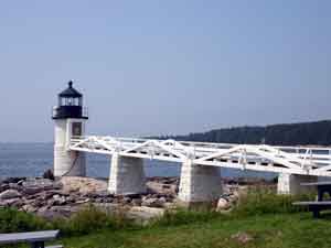
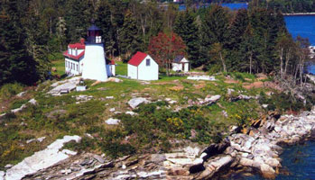
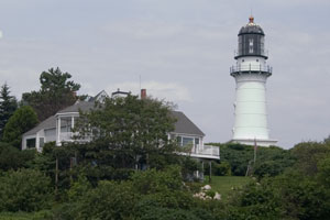
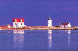
| ME 39 |
Marshall Point
latitude 43° 55' 2.6" N longitude 69° 15' 40.9" W
July 21, 2004 access: car
This little light is attached to a beautiful building. I couldn't get them in the same picture. (J 0124) ARLHS # USA-479 |
|
| ME 41 |
Monhegan Island
access: car
Open to the public (J 0128) ARLHS # USA-509
Photo courtesy whitecloud [Webshots] |
|
| ME 42 |
| Franklin Island
latitude 43° 53' 31.9" N longitude 69° 22' 29.7" W
access: boat
Visit by boat only ARLHS # USA-309
Photo courtesy whitecloud [Webshots] |
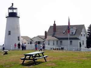
| ME 43 |
Pemaquid Point
latitude 43° 50' 12.9" N longitude 69° 30' 21.8" W
July 21, 2004 access: car
This is a dedicated park, not much bigger than the light house plot, but with a nice parking lot and attendance fee. It also has a lovely gift shop next door, so we were both happy.
Take route 129 to route 130 and follow all the way to the light. (J 0134) ARLHS # USA-589 |
|
| ME 44 |
| Ram Island
latitude 43° 48' 14.3" N longitude 69° 35' 57.8" W
access: boat
Tours available from Boothbay Harbor or Bath. The light is off Ocean Point, guarding the channel "Fisherman's Passage." (J 0136) ARLHS # USA-686
Photo courtesy whitecloud [Webshots] |
| ME 45 |
Burnt Island
latitude 43° 49' 30.4" N longitude 69° 38' 24.9" W
access: boat
Board The Novelty at Pier 8 in Boothbay Harbor. The light is located on the west side entrance to Boothbay Harbor. (J 0140) ARLHS # USA-097
Photo courtesy whitecloud [Webshots] |
|
| ME 46 |
![[The] Cuckolds](ECU/Maine/Cuckolds.jpg)
| [The] Cuckolds
latitude 43° 46' 47.3" N longitude 69° 39' W
access: boat
Accessible by boat or helicopter only.
Boothbay Harbor (J 0142) ARLHS # USA-210
Photo courtesy purplehazel [Webshots] |
| ME 47 |
Hendricks Head
latitude 43° 49' 21.4" N longitude 69° 41' 22.3" W
July 21, 2004 access: car
This light is private property, so the picture is taken from the neighboring beach. Given that the weather was warm, there was zero parking available, so Marnie double parked as I took this picture with the long lens, then we got out of everybody's way.
Take route 27 south the Beach Road. Luckily, there is a small roundabout there, or you'd miss the turn. (J 0144) ARLHS # USA-369 |
|
| ME 48 |
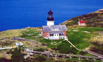
| Seguin Island
latitude 43° 42' 26.7" N longitude 69° 45' 28.7" W
access: boat
Contact Maine Maritime Museum in Bath. The light is located 2 miles south of the mouth of the Kennebec River and was Maine's second lighthouse. (J 0146) ARLHS # USA-746
Photo courtesy whitecloud [Webshots] |
| ME 49 |
Pond Island
latitude 43° 44' 24" N longitude 69° 46' 13" W
access: boat
Located on an island in the mouth of the Kennebec southeast of Popham Beach. A bird refuge (J 0148) ARLHS # USA-1145
Photo courtesy vigs65 [Webshots] |
|
| ME 50 |
| Perkins Island
latitude 43° 47' 12.2" N longitude 69° 47' 6.9" W
access: boat
Best seen from sightseeing cruises near Georgetown, ME (J 0152) ARLHS # USA-596
Photo courtesy queenbgeorge [Webshots] |
| ME 50A |
Fort Popham
latitude 43° 45' 18" N longitude 69° 46' 60" W
access: boat
Fort Popham is 15 miles from Bath on Route 209, two miles from Popham Beach State Park. This light can be seen from some scenic cruises leaving Boothbay Harbor and Bath. (J 0150)
Photo courtesy Alex Trabas [ListOfLights] |
|
| ME 51 |
| Squirrel Point
latitude 43° 48' 59.8" N longitude 69° 48' 8.3" W
access: boat or walk (1 mile)
The remote lighthouse is accessible only by boat or on foot from an unmarked trail off Bald Head Road in Arrowsic. The hike in takes about 20 minutes. (J 0156) ARLHS # USA-798
Photo courtesy Aliki [Flickr] |
| ME 52 |
Doubling Point Range
latitude 43° 52' 58.9" N longitude 69° 47' 46.5" W
access: boat
On Arrowsick Island, still active Coast Guard (J 0160 and J 0161.1) ARLHS # USA-415
Photo courtesy queenbgeorge [Webshots] |
|
| ME 53 |
| Doubling Point
latitude 43° 52' 56.3" N longitude 69° 48' 24.3" W
access: car
South of Bath, ME on route 127 (J 0166) ARLHS # USA-234
Photo courtesy queenbgeorge [Webshots] |
| ME 53B |
Abagadasset Point (2 lights) |
East shore of Kennebec River, about five miles north of Bath, opposite Abagadasset Point. The ruins of the front light are about all that remain. |
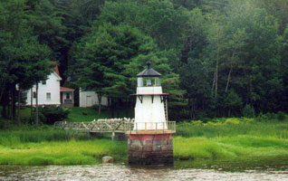
| ME 54 |
Portland Breakwater (The Bug)
latitude 43° 39' 20.2" N longitude 70° 14' 5.6" W
August 1, 2006 access: car
Actually in South Portland, there is a park here labeled Bug Light Park and the grounds are open to the public ARLHS # USA-659 |
|
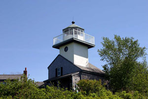
| ME 54C |
| Portland Channel
access: car + long lens
There are actually more lights around here than you can count. Many people wouldn't count this channel marker, but it looks to me like it's permanently fixed (not floating) and has a light (not just a bell). This photo was taken from the end of the breakwater (above). |
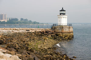
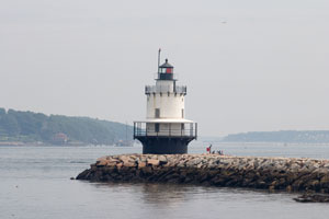
| ME 55 |
Spring Point Ledge
latitude 43° 39' 7.6" N longitude 70° 13' 26.3" W
August 1, 2006 access: walk or long lens
Just south of Bug light is the Portland Harbor Museum. You can walk out the breakwater or use your long lens to avoid the walk. (J 0195) ARLHS # USA-785 |
|
| ME 56 |
| Ram Island Ledge
latitude 43° 37' 53.4" N longitude 70° 11' 15" W
August 1, 2006 access: boat
This picture is from right next to the Fog Signal of Portland Head light. It was pretty hazy, so this has been extensively modified to make it look "nice." (J 0204) ARLHS # USA-687 |
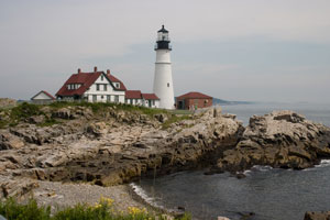
| ME 57 |
Portland Head
latitude 43° 37' 23.2" N longitude 70° 12' 28.6" W
August 1, 2006 access: car
This is a beautiful lighthouse, on a gorgeous coast, and we were lucky that the second time was a charm as far as the weather goes.
Take State Route 77 south from Portland (ME) and you'll see signs pointing to the coast (left going south). Follow the signs to the Fort William Park where you will find both the fort and the lighthouse. (J 0206) ARLHS # USA-661 |
|
| ME 58 |
| Halfway Rock
latitude 43° 39' 21.6" N longitude 70° 2' 13" W
access: boat
Location: Casco Bay, eastern approach to Portland Harbor; Nearest town: Harpswell, Maine
Accessibility: The lighthouse is not open to the public. It can be reached only by boat or helicopter, and landing a boat is very difficult. It can be seen distantly from Land's End at the southern tip of Bailey Island. (J 0176) ARLHS # USA-364
Photo courtesy Jeremy d'Entremont [NewEnglandLights] |
| ME 59 |
Cape Elizabeth |
There are actually 2 lights here, but instead of being arranged in a range formation, they are designed so navigators can measure the angle between them, and know precisely where they are.
Take ME 77 south from Portland, turn left of 2 Lights Rd, then again on 2 Lights Terrace. |
| ME 59F |
Cape Elizabeth West
latitude 43° 33' 57.9" N longitude 70° 12' 0.4" W
August 1, 2006 access: car
This picture is from the coast. (J 0208) ARLHS # USA-115 |
|
| ME 59R |
| Cape Elizabeth East
latitude 43° 33' 51.1" N longitude 70° 12' 9.1" W
August 1, 2006 access: car
This picture was taken from the base of their driveway. ARLHS # USA-113 |
| ME 60 |
Wood Island
latitude 43° 27' 24.8" N longitude 70° 19' 44.5" W
access: boat
Boat access only (J 0214) ARLHS # USA-905
Photo courtesy squarepond [Webshots] |
|
| ME 61 |
| Goat Island (Cape Porpoise)
latitude 43° 21' 28.7" N longitude 70° 25' 30.4" W
access: boat
Located in Cape Porpoise Harbor, boat access only (J 0218) ARLHS # USA-325
Photo courtesy whitecloud [Webshots] |
| ME 62 |
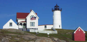
Cape Neddick (Nubble)
latitude 43° 9' 54" N longitude 70° 35' 27.6" W
July 20, 2002 access: car
A true "picture" by itself, this light is on an island connected to the mainland by a small overhead trolley. The lighthouse was erected in 1879. The picture is taken from Sohier park (he donated the land to the city) in York Beach, ME.
Highway 1 will take you to York Beach, then you need to navigate east to Neddick Point. Note, this is south of the village of Cape Neddick. (J 0226) ARLHS # USA-130 |
|
| ME 63 |
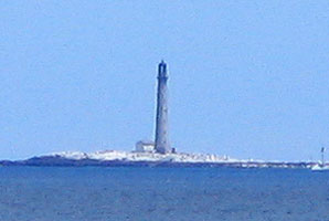
| Boon Island
access: car + long lens
Offshore of York, ME, best seen by boat
The photo was taken from the shore, then digitally zoomed. (J 0228) ARLHS # USA-071
Photo courtesy Donna McCraw [Flickr] |
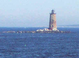
| ME 64 |
Whaleback Ledge
latitude 43° 3' 31.1" N longitude 70° 41' 46.6" W
July 20, 2002 access: car + long lens
There are a pair of lights protecting the shoals in front of Portsmouth. Technically, this is in Maine. Here is one. The other is in New Hampshire. VT 2 (J 0232) ARLHS # USA-963 |
|
| ME 65 |
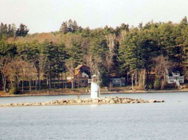
| Lady's Delight
access: boat
Fresh water lighthouse in Lake Cobbosseecontee. The lighthouse can be seen distantly from various points along the shoreline, but a boat is really needed to get a good view of the lighthouse. Boats can be rented from Lakeside Motel and Cabins, near the northern end of the lake. lodging ARLHS # USA-1127
Photo courtesy queenbgeorge [Webshots] |
|
|
If you would like copies of any of my pictures, contact me and we'll discuss arrangements. There are others who do this commercially, I have no intention of competing directly, but you can make a proposal, and I'll react. mailMe