|
This page currently shows many of Lighthouses of the Massachusetts. Copies of these pictures are stored on Flickr if you want to download them. Note that Google Map link shown above covers Northern Massachusetts and Vermont (but contains a link to a Google Map of Southern Massachusetts including Cape Cod and the Islands.) Flickr Index numbers are from the Shanklin List of all US lights. p2 |
|
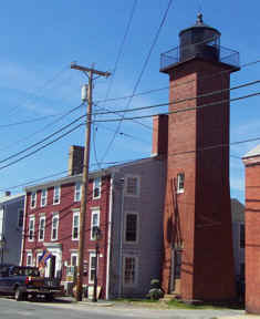
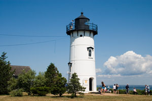
| MA 1 |
Newbury Port Rear Range Light
latitude 42° 48' 40.5" N longitude 70° 51' 57.9" W
June 20, 2002 access: car
This rear range light is right next to the street that borders the coast.
Take highway 1 to Newburyport MA, then Merrimack Street south to Water Street. ARLHS # USA-545 |
|
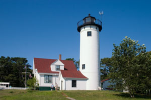
| MA 2 |
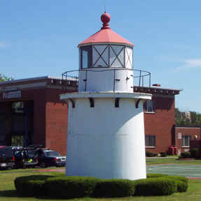
| NewburyPort Front Range Light
latitude 42° 48' 41.4" N longitude 70° 51' 53.3" W
June 20, 2002 access: car
The front range (matching the light above) is located on the Coast Guard post in downtown Newburyport. ARLHS # USA-1097 |
| MA 3 |
Newbury Port Harbor |
From the Newburyport Harbor Range Lights on Water Street in downtown Newburyport, continue east on Water Street for 1.3 miles, where Water Street will become Plum Island Turnpike. Follow the turnpike for 1.8 miles to Plum Island, and then turn left on Northern Boulevard. Continue on Northern Boulevard for 1.3 miles to the northern end of the island ARLHS # USA-544 |
| MA 4 |
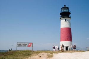
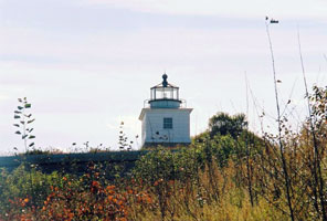
Annisquam
latitude 42° 39' 42.3" N longitude 70° 40' 52.9" W
access: car
From the junction of Highways 127 and 128 east of Gloucester, go north on Highway 127 for 3.1 miles. Turn left onto Leonard Street and then right onto Elizabeth Road (Norwood Heights) after 0.3 miles. Follow this road, crossing Ocean Avenue, until it tees. Turn right, and then make a quick left onto Wigwam Road. At the end of Wigwam Road turn right onto Lighthouse Road. (J 0268) ARLHS # USA-015
Photo courtesy Thom Perry [Flickr] |
|
| MA 4A |
Rockport Breakwater Light |
|
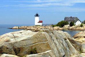
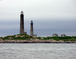
| MA 5 |
Straitsmouth Harbor
latitude 42° 39' 44.1" N longitude 70° 35' 16.5" W
access: boat
The closest point on land from which to view the lighthouse is at Gap Head, however Gap Head is private and a hill on the island blocks a view of the lighthouse from this area. We took a tour with Cape Ann Cruises, which provided a fair view of the lighthouse. cruises (J 0274) ARLHS # USA-815
Photo courtesy Alexander Trabas [ListOfLights] |
|
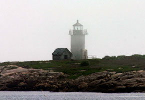
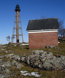
| MA 6 |
| Thachers Island
latitude 42° 38' 20.8" N longitude 70° 34' 28.7" W
access: boat
Thacher Island Campground & Lighthouse (circa 1771) P.O. Box 73, Rockport, MA 01966, (617) 599-2590
Harbor Tours Inc. of Cape Ann, out of Gloucester, offers a Lighthouse Cruise that passes by the island. ARLHS # USA-1027
Photo courtesy Al Angelici [Flickr] |
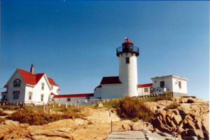
| MA 7 |
Eastern Point
latitude 42° 34' 48.7" N longitude 70° 39' 52.1" W
access: car
From the junction of Highways 127 and 128 in downtown Gloucester, go east on East Main Street for just over a mile, where the road will become Eastern Point Road. Continue on Eastern Point Road 0.3 miles to Eastern Point Boulevard. Follow Eastern Point Boulevard 1.6 miles to its end at a parking area near the lighthouse (J 0280) ARLHS # USA-263
Photo courtesy pats7288 [Webshots] |
|
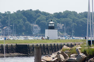
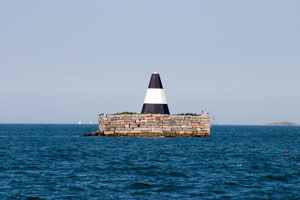
| MA 8 |
| Gloucester Breakwater
latitude 42° 34' 57.2" N longitude 70° 40' 20.6" W
access: car
Located at the end of the ½ mile Dog Bar Breakwater at Eastern Point in Gloucester. (J 0282) ARLHS # USA-969
Photo courtesy avendesoora [Flickr] |
| MA 9 |
Ten Pound Island
latitude 42° 36' 6.7" N longitude 70° 39' 54.8" W
July 18, 2004 access: car
Checking out potential locations for the Stephen/Tia wedding, we came across this light.
Take 128 north from Boston, then 133 east to the T. The light is dead ahead on the island. (J 0284) ARLHS # USA-839 |
|
| MA 10 |
| Baker's Island
latitude 42° 32' 11.7" N longitude 70° 47' 9.4" W
access: boat
seen distantly from Salem Willows Park and Winter Island in Salem
The Essex National Heritage Commission began offering boat tours to Baker's Island Lighthouse during the summer of 2015. (J 0288) ARLHS # USA-031
Photo courtesy tllebron [Webshots] |
| MA 11 |
Hospital Point
latitude 42° 32' 47.1" N longitude 70° 51' 21.4" W
July 12, 2008 access: car + walk
From Highway 127 in Beverly, turn towards the harbor on East Corning Street. After 0.3 miles, East Corning Street ends. From this point, take Bayview Avenue which ends at the lighthouse. At low tide, it is possible to walk along the shoreline from Lynch Park to get a view of the front of the lighthouse. Lynch park is west of the lighthouse and is reached by taking a right on Neptune Street where East Corning Street ends (J 0290) ARLHS # USA-389 |
|
| MA 12 |
| Hospital Point Rear Range
latitude 42° 32' 53.5" N longitude 70° 52' 41.9" W
access: car
From the northern end of the Highway 1A's bridge over the Porter River in Beverly, follow Highway 22 for just under a mile. Beverly Baptist Church will be on your right at 221 Cabot Street. (J 0290.1) ARLHS # USA-390
Photo courtesy Maria Pratt [weshots] |
| MA 13 |
Fort Pickering
latitude 42° 31' 35.2" N longitude 70° 51' 59.3" W
July 12, 2008 access: car
(We did an end-run for this photo.)
From Highway 1A in Salem, 0.7 miles south of the bridge over the Porter River, turn east on Webb Street. When Webb Street ends, turn left onto Derby Street/Fort Avenue and continue to Winter Island Road. Turn right onto Winter Island Road and follow it to its end. After paying $20 to enter the park, stay left and the road will lead to the lighthouse. (J 0294) ARLHS # USA-901 |
|
| MA 14 |
| Derby Wharf
latitude 42° 30' 59.2" N longitude 70° 53' 1" W
July 12, 2008 access: car
From Highway 1A in Salem, go east on Derby Street. ARLHS # USA-224 |
| MA 15 |
Marblehead
latitude 42° 30' 19.6" N longitude 70° 50' 1.2" W
access: car
At then end of Highway 129 in Marblehead, turn east onto Ocean Avenue and follow it across the causeway onto Marblehead Neck. Follow Ocean Avenue until it ends at Follett Street. Turn left onto Follett Street, which leads to the lighthouse. (J 0304) ARLHS # USA-473
Photo courtesy Luis LeBron [Flickr] |
|
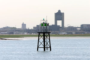
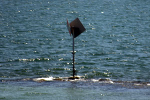
| MA 15N |
| Boston Harbor, Mick's Mate
July 30, 2006 access: boat or public ferry
On the way out to Georges Island, we saw this "lighthouse" in the distance. On the way back, we came much closer and can clearly see that while it is a channel marker, it's not a light. |
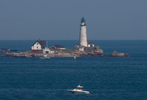
| MA 16 |
Boston Harbor (Graves Light)
latitude 42° 21' 54.2" N longitude 70° 52' 9.1" W
July 30, 2006 access: boat
It's a long way from the fort on Georges Island to this light, so I'm not using my photo here. (J 0310) ARLHS # USA-341
Photo courtesy Debbie Burleigh [Flickr] |
|
|
|
| MA 17W |
| Winthrop
Entrance to dredged channel #1 (J 0340)
Photo courtesy Alex Trabas [ListOfLights] |
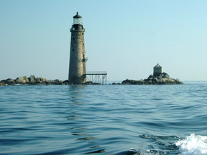
| MA 17 |
Boston Harbor Light
latitude 42° 19' 40.6" N longitude 70° 53' 24.3" W
July 30, 2006 access: boat
The light is on Little Brewster Island and officially marks the entrance to Boston Harbor. Built in 1824, this is the oldest lighthouse in New England. This picture was taken from the Fort on Georges Island. Careful selection of Harbor Tour might get you closer, but as for now, this is the best we can do (J 0314) ARLHS # USA-073 |
|
| MA 18 |
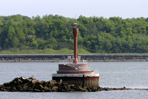
| Deer Island
latitude 42° 20' 23.3" N longitude 70° 57' 16.1" W
access: car + walk
The island is now attached to the mainland, and a walking trail surrounds much of the island. The island is part of the Boston Harbor Islands park, and you can drive to the island from where you can see the lighthouse. It currently is only an automated light on a post, at one time it was a sparkplug design. deer island (J 0324) ARLHS # USA-1096
Photo courtesy Alexander Trabas [ListOfLights] |
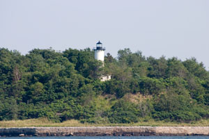
| MA 19A |
The Narrows |
ARLHS # USA-960 |
| MA 19 |
Long Island Head (Boston Harbor)
latitude 42° 19' 48.5" N longitude 70° 57' 27.9" W
July 30, 2006 access: boat or public ferry
This picture was taken from the deck of a Boston Islands "T" boat. It's still well in the distance, so you are seeing the result of a long lens to get here. (J 0337) ARLHS # USA-449 |
|
| MA 20 |
| Minots Ledge
latitude 42° 16' 11.6" N longitude 70° 45' 33.6" W
access: boat
Built to mark dangerous submerged Cohasset Rocks off the coast of Cohasset six miles southeast of Boston Harbor. Minots Ledge is also called “the most dangerous beacon in America” because the Lighthouse was built on a hazardous submerged rock about 25-feet wide that is only exposed 2 to 3 hours every day at low tide. (J 0360) ARLHS # USA-502
Photo courtesy Pats7288 [Webshots] |
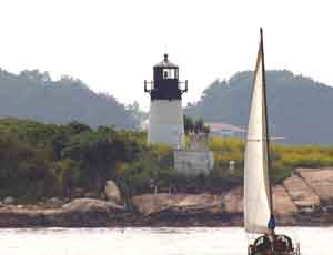
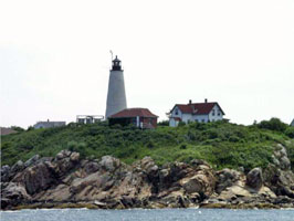
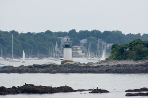
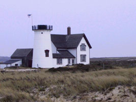
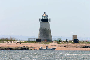
| MA 21 |
Scituate
latitude 42° 12' 16.9" N longitude 70° 42' 56.6" W
August 2, 2016 access: car
From Route 3 east of Scituate, take First Parish Road east for 0.9 miles to Beaver Dam Road, and then continue east on Beaver Dam Road for 1.3 miles to Jericho Road. Turn left on Jericho Road and follow it around the harbor to Lighthouse Road. (J 0363) ARLHS # USA-742 |
|
| MA 22 |
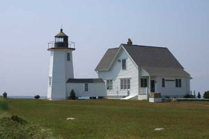
| Plymouth (the Gurnet)
latitude 42° 13.4" N longitude 70° 36' 1.9" W
access: boat or walk (4 mile)
To access the lighthouse by land a four-mile, one-way hike would be necessary as road access is prevented by private property. The light would be most easily viewed from a boat out of Plymouth. (J 0366) ARLHS # USA-609
Photo courtesy Luis LeBron [Webshots] |
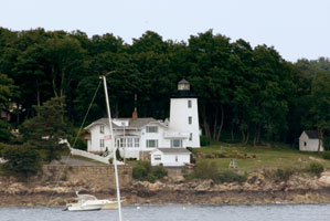
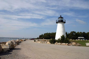
| MA 23 |
Duxbury Pier
latitude 41° 59' 14.8" N longitude 70° 38' 54.8" W
access: boat
One can take a tour with Plymouth Harbor Cruises aboard the Pilgrim Belle, which leaves from Plymouth Harbor. cruises (J 0368) ARLHS # USA-251
Photo courtesy pwhsu48 [Webshots] |
|
| MA 24 |
| Sandy Neck
latitude 41° 43' 21.4" N longitude 70° 16' 51.2" W
access: boat
Barnstable whale watching cruises that leave from the marina also pass by the light. To reach the marina, take exit 6 from Route 6 and go north on Route 132 to Route 6A. Turn right on Route A and continue for 2.6 miles to Mill Way. Turn left on Mill Way and follow it to the marina at its end. (J 0375.5) ARLHS # USA-732
Photo courtesy pwhsu48 [Webshots] |
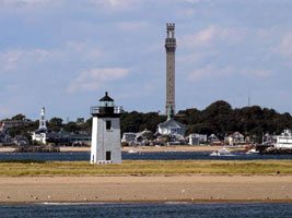
| MA 25 |
Long Point
latitude 42° 1' 59.7" N longitude 70° 10' 7.3" W
access: walk (2.7 mile) or kayak
You can view this lighthouse from Provincetown, but the view is a distant, unsatisfactory one. To visit the light, you can make the strenuous, 2.7 mile walk to the lighthouse, or you can take a shuttle or paddle a kayak to Long Point.
Flyers Boat Yard rents kayaks and also provides shuttle service to Long Point. flyers (J 0382) ARLHS # USA-450
Photo courtesy pwhsu48 [Webshots] |
|
| MA 26 |
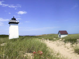
| Wood End
latitude 42° 1' 16" N longitude 70° 11' 36.5" W
access: walk (1 mile) or kayak + walk
You can view this lighthouse from Commercial Street in Provincetown at the foot of the breakwater, which leads to the lighthouse, but the views are distant. To reach the lighthouse, you can walk the ½ mile breakwater, and then trudge another ½ mile through sand. Another option would be to rent a kayak and paddle to the light, but a hike through the sand is still required Flyers Boat Rental (J 0383) ARLHS # USA-904
Photo courtesy pats7288 [Webshots] |
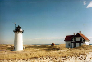
| MA 27 |
Race Point
latitude 42° 3' 43.7" N longitude 70° 14' 36" W
access: walk (1.7 mile) or tour
This lighthouse can be reached by hiking west 1.7 miles through the sand from Race Point Beach. To reach Race Point Beach, take the Race Point exit from Route 6 near Provincetown, and follow Race Point Road until it ends at the beach. Art's Dune Tours offers trips out to the lighthouse.
Art's Dune Tours can be reached at (800) 894-1951. tour (J 0386) ARLHS # USA-680
Photo courtesy Pats7288 [Webshots] |
|
| MA 28 |
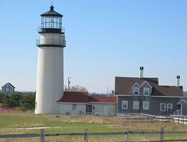
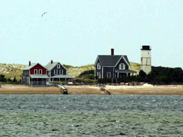
| Highland (Cape Cod)
latitude 42° 2' 21.3" N longitude 70° 3' 43.8" W
access: car
Traveling north on Route 6, the Highland Lighthouse area is 3.3 miles north of Truro Center. (J 0390) ARLHS # USA-110
Photo courtesy H.H. Schueller [Flickr] |
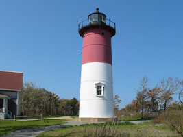
| MA 29 |
Nauset Beach
latitude 41° 51' 36.3" N longitude 69° 57' 10.5" W
access: car
Take Route 6 north on the cape to Eastham and Bracket Road, the third traffic signal from the Eastham/Orleans rotary. Turn right onto Bracket Road and continue until it ends at Nauset Road. Turn left onto Nauset Road and then take the first right onto Cable Road. At the end of Cable Road, turn left onto Ocean View Drive (J 0392) ARLHS # USA-529
Photo courtesy Donna McCraw [Flickr] |
|
| MA 30 |
| Three Sisters of Nauset
latitude 41° 51' 33.6" N longitude 69° 57' 25.5" W
access: car
Take Route 6 north on the cape to Eastham and Bracket Road, the third traffic signal from the Eastham/Orleans rotary. Turn right onto Bracket Road and continue until it ends at Nauset Road. Turn left onto Nauset Road and then take the first right onto Cable Road. At the end of Cable Road, turn left onto Ocean View Drive where there is a parking lot available. ARLHS # USA-528
Photo courtesy Pats7288 [Webshots] |
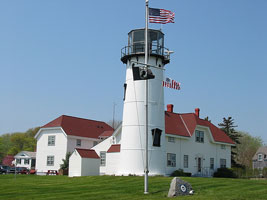
| MA 31 |
Chatham
latitude 41° 40' 16.7" N longitude 69° 56' 59.5" W
access: car
Take Route 28 to the roundabout in Chatham, and from there follow Main Street through Chatham. Main Street will make a sharp right turn when it intersects with Shore Road. From this point, go south on Main Street 0.4 miles to the lighthouse. (J 0394) ARLHS # USA-158
Photo courtesy Donna McCraw [Flickr] |
|
|
|
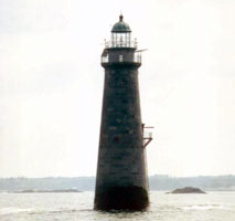
| MA 32 |
Monomoy Point
latitude 41° 33' 33.4" N longitude 69° 59' 37.2" W |
The Friends of Monomoy offer overnights in the keeper's quarters on South Monomoy Island. These trips are the best way to see the lighthouse, but you can also reach the island by private boat and hike to the lighthouse. You can reach Friends of Monomoy at (508) 945-0594.
Monomoy Island Ferry offers trips to the island that should be able to get you near the lighthouse. ferry ARLHS # USA-051 |
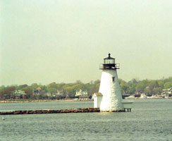
| MA 33 |
Stage Harbor
latitude 41° 39' 31" N longitude 69° 59' 1.1" W
access: car
From Highway 28 in West Chatham, turn south on Barn Hill Road. After 0.4 miles, bear right onto Hardings Beach Road. Continue for 0.8 miles to the parking area at the beach. The lighthouse can be reached from the beach by following a sandy road east along the shore for just over a mile. The lighthouse can also be seen from a distance across Stage Harbor by proceeding south from the rotary in Chatham on Stage Harbor Road. Stage Harbor Road will become Champlain Road after about 1.2 miles. Continue on Champlain Road for about 0.6 miles to Sears Road. Follow Sears Road to the boat launching area ARLHS # USA-806
Photo courtesy Pats7288 [Webshots] |
|
| MA 34 |
| Bass River
latitude 41° 39' 6.2" N longitude 70° 10' 9.7" W
access: car
From Route 28 in West Dennis just east of Bass River, turn south on School Street. Follow School Street for one-half mile and then turn right onto Lighthouse Road. Take Lighthouse Road for 0.2 miles and then turn left onto Lighthouse Inn Road. (J 0425.7) ARLHS # USA-042
Photo courtesy lightlady35 [Webshots] |
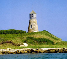
| MA 35 |
Point Gammon
latitude 41° 36' 34.6" N longitude 70° 15' 58.4" W
access: boat
The lighthouse can be seen distantly from the beach near the Hyannis Lighthouse, but the best views come from the water. One can go blue water sailing aboard the Cat Boat from Hyannis, which affords closer, but still distant views of the light. * ARLHS # USA-622
Photo courtesy whitecloud [Webshots] |
|
| MA 35S |
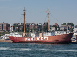
| Lightship Nantucket
July 5, 2010 access: public ferry
Originally built in 1950, this boat served on both the west coast (San Francisco) and the east coast where it ended up at Nantucket. At this point it is in private ownership and is available for charter or for parties. ARLHS # USA-078 |
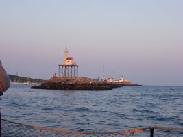
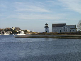
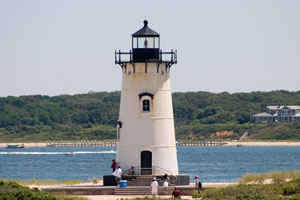
| MA 36 |
Nantucket Range Lights
latitude 41° 17' 22.7" N longitude 70° 5' 32.4" W
August 5, 2006 access: boat
As you may note from the next 3 listings, there are 3 sets of lights at Nantucket harbor. This is the range light set. Even more interesting, we saw these lights as part of a Rhode Island tour, but Nantucket and Martha's Vineyard are part of Massachusetts. (J 0416 and 0416.1) ARLHS # USA-078 |
|
| MA 37 |
| Old Brant Point
latitude 41° 17' 22.9" N longitude 70° 5' 32.6" W
August 5, 2006 access: walk
Lighthouses have not done well on Nantucket. This is the 1896 version, which is the 9th light built here. It was replaced by the light shown below. ARLHS # USA-1094 |
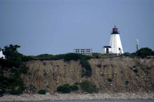
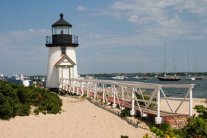
| MA 38 |
Brant Point
latitude 41° 17' 23.6" N longitude 70° 5' 25.1" W
August 5, 2006 access: walk
This is the currently active (plus the range lights shown above) light at the mouth of Nantucket harbor. It was built in 1902 replacing the light above. It's small (note how big the 6' something door looks compared to the rest of the tower), but is picturesque enough that others are copying the model ARLHS # USA-1095 |
|
| MA 39 |
| Great Point
latitude 41° 23' 24.1" N longitude 70° 2' 53.6" W
From May to October, the Trustees of Reservations present a daily natural history tour at Coskata-Coatue Wildlife Refuge. * (J 0404) ARLHS # USA-348
Photo courtesy Maria Pratt [Flickr] |
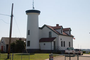
| MA 40 |
Sankaty Head
latitude 41° 17' 1.2" N longitude 69° 57' 54.7" W
August 5, 2006 access: car
This light was in danger of erosion, they figure a few more years (or one big storm) and it will be gone. It was moved in 2007. This photo (and the coordinates) is the old location.
We got to walk up in the tower (60 steps, plus 9 more on a ladder) and the view is outstanding. (J 0406) ARLHS # USA-735 |
|
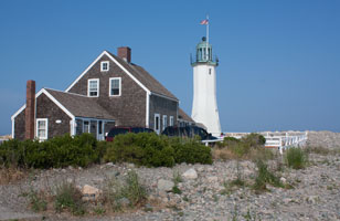
| MA 41 |
| Hyannis Harbor
latitude 41° 38' 10.7" N longitude 70° 17' 18.4" W
access: car
Located at the end of Harbor Road on Hyannis Harbor.
From the intersection of Highways 132 and 28 north of Hyannis, turn south on Hyannis-Barnstable Road. In Hyannis, continue south on Ocean Street to Gosnold Street. Turn right on Gosnold Street and drive 0.4 miles to Harbor Road. Turn left on Harbor Road, where the lighthouse will be on your right near the end of the road. ARLHS # USA-397
Photo courtesy tllebron [Webshots] |
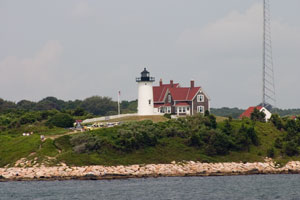
| MA 42 |
Nobska Point
latitude 41° 30' 56.7" N longitude 70° 39' 18.4" W
August 7, 2006 access: car
This light is just east of Wood's Hole on Cape Cod. We took the picture from our cruise, but looking at the people walking along the shore, it is also possible to get here on the ground.
Take Route 28 to Falmouth and then turn south on Shore Street. When Shore Street ends, turn right on Surf Drive, which will become Beach Road after 0.4 miles. Follow Beach Road for 1.4 miles to Oyster Pond Road. After one mile on Oyster Pond Road, turn left on Nobska Road, which will take you to the lighthouse. ARLHS # USA-550 |
|
| MA 42a |
| Vineyard Haven Harbor
latitude 41° 27' 27.1" N longitude 70° 35' 46.9" W
August 6, 2006 access: boat
My mapping program had a "bunch" of lights that the index book didn't have. This light and the next are examples. I think the index book was correct in omitting them so these are not on webshots. (J 0432) |
| MA 42b |
Vineyard Haven Ferry Slip |
|
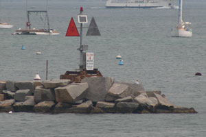
| MA 42c |
Oak Bluffs North Breakwater
latitude 41° 27' 40.2" N longitude 70° 33' 24.8" W
August 6, 2006 access: boat
This "light" is actually on a set of rocks which keep the swimming area less turbulent, and "teach" boaters not to come through at the same time. (J 0444) |
|
| MA 43 |
West Chop
latitude 41° 28' 50.5" N longitude 70° 35' 59.3" W
August 6, 2006 access: car
Vineyard haven is a long and narrow harbor. The West end is marked with this light. It still has 2 keepers cottages in place (only one is shown here) and is also the source of the fog horn signal for the entire harbor. (J 0450) ARLHS # USA-877 |
|
| MA 44 |
| East Chop
latitude 41° 28' 12.9" N longitude 70° 34' 2.9" W
August 6, 2006 access: car
On the other side of the harbor (from above) is this light. It's a cast iron shrouded brick building, pretty much the same design as Portsmouth harbor (see above). The keeper's house is long gone, but the area is public owned. ARLHS # USA-259 |
| MA 45 |
Edgartown Harbor
latitude 41° 23' 26.5" N longitude 70° 30' 10.8" W
August 6, 2006 access: car
Yes, we did see a bunch of lights this day of the tour. Readers will note a resemblance to the one above. Differences are very minute, until you step inside. This one does not have a spiral staircase, it just has a ladder. And it's not brick lined, it actually was floated across the bay from near Wood's Hole. ARLHS # USA-265 |
|
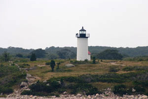
| MA 46 |
| Cape Poge
latitude 41° 25' 7.9" N longitude 70° 27' 7" W
August 5, 2006 access: boat, walk (3 miles) or tour
This is on an isolated point of Martha's Vineyard (6 miles of beach to cross to get here). So we could arrive as early as possible tomorrow, I grabbed this picture with the long lens at the end of the day, added digital filtering to brighten it up, and this is what we get. ARLHS # USA-132 |
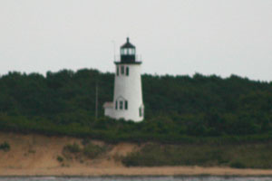
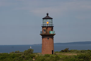
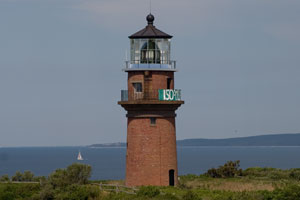
| MA 47 |
Gay Head
latitude 41° 20' 54.2" N longitude 70° 50' 5.8" W
August 6, 2006 access: car
This light is on the Atlantic ocean, and right below it is a very striated cliff with several layers of sand. So the "gay" is not intended to discuss sexual orientation, but "pleasureful".
From Vineyard Haven and Oak Bluffs, follow signs west to Chilmark. At Chilmark, continue west on South Road, which will end in a loop at the lighthouse. (J 0476) ARLHS # USA-319 |
|
| MA 47i |
| Gay Head Imaginary
access: none
At the museum in Egdartown, they have the original Gay Head Fresnel lens on display. This picture is a composite of the current light, with the original lens reinserted. This photo is not on webshots. |
| MA 47a |
Menamsha Creek Entrance |
|
| MA 48 |
Tarpaulin Cove
latitude 41° 28' 7.6" N longitude 70° 45' 26.9" W
August 7, 2006 access: boat
This light is on a private island. About the only way to get here is to charter a boat or be a relative of the Forbes family. We had some extra time on this leg of the cruise, so Jeremy persuaded the captain to take a less direct route and we got this picture ARLHS # USA-835 |
|
| MA 49 |
| Wing's Neck
latitude 41° 40' 48.6" N longitude 70° 39' 40" W
access: car
From Route 28 near Pocasset, turn west on Barlows Landing Road. After crossing Shore Road, bear right on Wings Neck Road and follow it to its end. ARLHS # USA-899
Photo courtesy David Stoy [Webshots] |
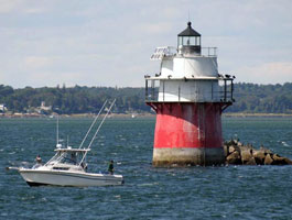
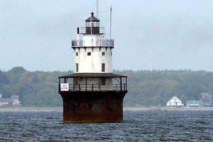
| MA 50 |
Cleveland Ledge
access: boat
Located on a reef on the east side of the main Buzzard's Bay channel, off West Falmouth. (J 0510) ARLHS # USA-179
Photo courtesy Alex Trabas [ListOfLights] |

|
| MA 50R |
| Cleveland Ledge Rear
Located on the east side of the main Buzzard's Bay channel, off West Falmouth. (J 0510.1)
Photo courtesy Alex Trabas [ListOfLights] |
| MA 51 |
Bird Island
latitude 41° 40' 9.1" N longitude 70° 43' 2.6" W
From Route 6 northeast of Marion, turn south on Point Road. Follow Point Road to the Kitanset Golf Club at its end from where views of the light are possible. ARLHS # USA-057
Photo courtesy Alex Trabas [ListOfLights] |
|
| MA 52 |
| Ned's Point
latitude 41° 39' 3.2" N longitude 70° 47' 44.3" W
access: car
From Route 6 in Mattapoisett, turn south on North Street. When it ends, turn left onto Water Street, which will turn into Beacon Street as it bears to the right. Beacon Street will become Ned's Point Road, which ends after 0.5 miles at Veterans Memorial Park. (J 0504) ARLHS # USA-533
Photo courtesy David G Stoy [Webshots] |
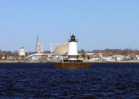
| MA 53 |
Buzzards Bay Entrance
latitude 41° 23' 49.3" N longitude 71° 2' 5.8" W |
Located at the mouth of Buzzards Bay, about 5 mi west southwest of Cuttyhunk. ARLHS # USA-100 |
| MA 54 |
Butler Flats
access: ferry
Good views are possible from the Martha's Vineyard and Cuttyhunk ferries that depart from New Bedford. For a decent view from land, take Route 18 south in New Bedford, which will become Water Street. From Water Street, turn left onto Cove Street and then right onto East Rodney French Boulevard. (J 0498) ARLHS # USA-099
Photo courtesy kksgram [Webshots] |
|
| MA 55 |
| Clarks Point
latitude 41° 35' 35.5" N longitude 70° 54' 4.8" W
access: car
Take Route 18 south in New Bedford. Route 18 will turn into Water Street and then West Rodney French Boulevard. Continue south and you will see Fort Taber Park. (J 0497) ARLHS # USA-174
Photo courtesy pats7288 [Webshots] |
| MA 56 |
Palmer Island
latitude 41° 37' 37" N longitude 70° 54' 32.9" W
access: ferry or tour
The lighthouse is accessible at low tide from the hurricane dike. To reach the wall, take Route 18 south in New Bedford and turn left onto Potomska Street. Make a quick right onto Front Street, which ends at Gifford Street. Turn left onto Gifford, which will take you behind some industrial buildings, where you can park and access the hurricane dike Cuttyhunk Ferry (J 0501) ARLHS # USA-578
Photo courtesy lightlady35 [Webshots] |
|
| MA 57 |
| Borden Flats
access: car
From I-195 on the eastern side of the Taunton River, go south on Route 138 to Bradford Avenue. Turn right onto Bradford Avenue, and then right onto Almond Street after three blocks. Follow Almond Street until it ends and turn left into the Borden Light Marine (J 0576) ARLHS # USA-072
Photo courtesy queenbgeorge [Webshots] |
|
|
