|
This page currently shows my understanding of Lighthouses of New Brunswick. Copies of these pictures are stored on the web if you want to download them.Click on [most] any photo and that will take you to that photo. Orange italicized numbers in parentheses are reference numbers used by the Canadian Coast Guard List of Lights (Atlantic Lights) p4 |
|
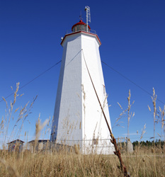
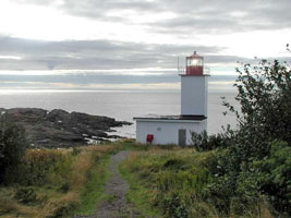
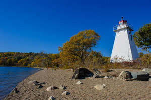
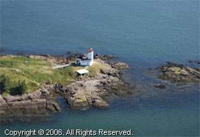
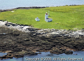
| NB 1 |
Inch Arran Point Range Bon Ami
Built in 1870.
Route 134, near Inch Arran Park. Near Dalhousie, NB. (1343) ARLHS # CAN-246
Photo courtesy hellien88 [Webshots] |
|
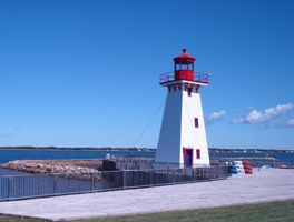
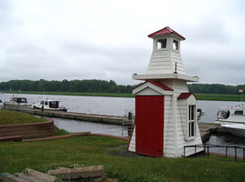
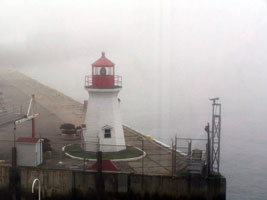
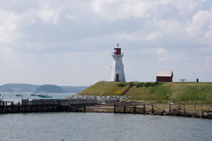
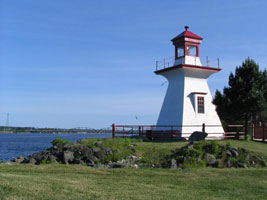
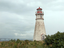
| NB 2 |
| Campbellton
latitude 48° 36.9" N longitude 66° 40' 17.9" W
June 27, 2008
On the city's waterfront south of the Restigouche River. (1351) ARLHS # CAN-070 |
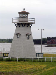
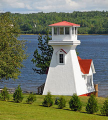
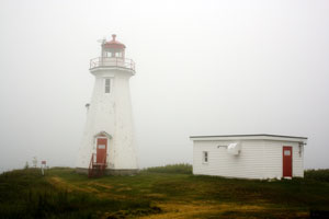
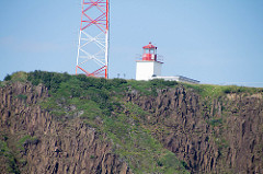
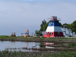
| NB 3 |
Miscou Island
The light is the traditional cedar-shake building that in this case has been standing since 1846. Noteworthy is the revolving Fresnel lens (the only one in New Brunswick.)
Route 11, Exit 217, drive to the end of Route 113. (1265) ARLHS # CAN-320
Photo courtesy Gavatron [Flickr] |
|
| NB 3A |
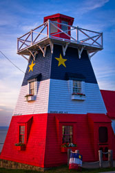
| Grande Anse (faux)
Note that this an artificial light built to be a visiter Information Center.
Photo courtesy ... some guy [Flickr] |
| NB 4 |
Big Shippegan |
From the town of Shippagan, take Highway 113 to Lamèque Island and take the first right after the bridge. After about 3 miles, in the village of Chiasson, turn right on Domitien Lane, an unpaved lane, drive slowly as the sandy roadway is pretty rough. (1254) ARLHS # CAN035 |
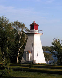
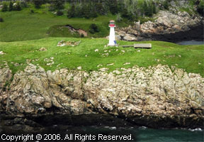
| NB 5 |
Shipphagan (Portage Island)
This lighthouse was originally the rear range light on Portage Island in Miramichi Bay. When the two towers of the Portage Island range were replaced by skeleton structures, the rear lighthouse was moved to Shippagan in 1986. (1176) ARLHS # CAN-733
Photo courtesy Mark Blevis [Flickr] |
|
| NB 7 |
Cape Enragé
The Lighthouse is located off Route 915, approximately 20 minutes from Alma. A cautionary note though, if you are towing a trailer, or driving a large RV, the last kilometer of the road, just past the Cape Enrage pebble beach, is twisted, narrow and steep in places. (157) ARLHS # CAN-096
Photo courtesy rjProduct [Flickr] |
|
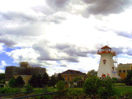
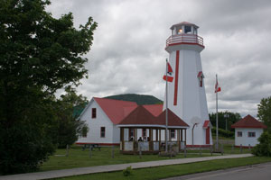
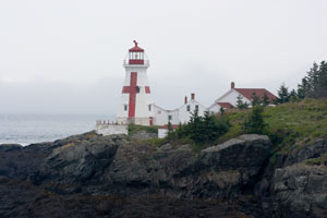
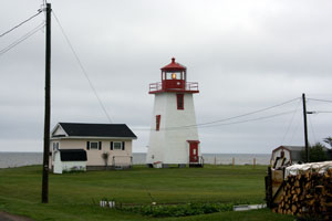
| NB 9 |
Quaco Head
"Quaco" is from the language of the local Indian tribe (Mi’kmaq). It means "Haunt of the Hooded Seal." The lantern and lens from the 1883 tower here are incorporated into a lighthouse replica that serves as the St. Martins Tourism Centre.
Take West Quaco Road off Route 111. (150) ARLHS # CAN-421
Photo courtesy djbjr [Webshots] |
|
| NB 10 |
Cape Spencer
latitude 45° 11' 42.7" N longitude 65° 54' 35.5" W |
From East Saint John, take the road to Red Head and drive all the way to the end. (146) ARLHS # CAN-109 |
| NB 11 |
Gagetown Ferry
latitude 45° 46' 7" N longitude 66° 8' 24" W
West side of river.
This picture was taken at the marina, the ferry is just down the road. To be honest I can't remember if there's another one at the ferry or not...but I believe there is. (135) ARLHS # CAN-190
Photo courtesy Christina Quigley [Flickr] |
|
| NB 12 |
| Oak Point Front Range
latitude 45° 30' 26.8" N longitude 66° 4' 48.7" W
The tower has been moved from Oak Point to Millbank, near Miramichi. It can be seen from Highway 11.<
Photo courtesy Dennis Jarvis [wikipedia] |
| NB 13 |
Oak Point Rear Range
I'm guessing a bit on the Oak Point photos. Anybody who has local knowledge can pass that on with my blessings.
Photo courtesy bigsister861 [Webshots] |
|
| NB 15 |
Belyea's Point
No Public Access.
(122) ARLHS # CAN-031
Photo courtesy Corey Balazowich [Flickr] |
|
|
|
| NB 16 |
Sand Point |
No Public Access
Located near the southern end of the Kingston Peninsula, at the terminus of Sand Point Wharf. (121) ARLHS # CAN-445 |
| NB 17 |
Bayswater |
Route 845, located on roadside. Located on the West side of Milkish Inlet, in the Parish of Westfield, Kings County. (120) ARLHS # CAN-025 |
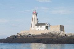
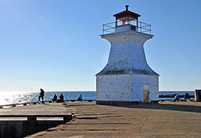
| NB 20 |
Courtney Bay
latitude 45° 15' 26.1" N longitude 66° 2' 41.6" W |
The lighthouse is at the end of a long breakwater on the east side of Saint John Harbour. There is no public access but the lighthouse can be seen from the water. (110.3) ARLHS # CAN 906 |
| NB 21 |
St. John Harbour
This "faux" lighthouse is near the end of a wharf on the Coast Guard base on Water Street. It can be seen from across Market Slip.
The 4th order Fresnel lens was removed from Brier Island in the 1980s. (101) ARLHS # CAN-943
Photo courtesy RJ Product [Flickr] |
|
| NB 22 |
Partridge Island
latitude 45° 14' 21.4" N longitude 66° 3' 12.9" W |
This was the first lighthouse erected in New Brunswick (1791). The existing lighthouse can be seen from various points in Saint John Harbour. Permission from the Canadian Coast Guard is required to access the island. (100) ARLHS # CAN-365 |
| NB 23 |
Musquash Head
latitude 45° 8' 37.5" N longitude 66° 14' 14.2" W
Route 1, figure 1 hour or more from route 1.
Exit 112 to Lorneville. Follow King William Roais bd to Black Beach. You then have a 1.4km walk to the lighthouse. The light is behind the power plant (97) ARLHS # CAN-333
Photo courtesy Dustin Brown [Flickr] |
|
| NB 24 |
Chance Harbour |
On Reef Point, west side of Harbour entrance. At best guess about where this light is, it's about a ½ mile walk from the road across Reef Point to the light. It's not clear if this is open for walkers, it clearly is not a public road. (93) ARLHS # CAN-125 |
| NB 25 |
Point Lepreau
latitude 45° 3' 31.6" N longitude 66° 27' 31.4" W |
There is no public access to the lighthouse, which is located on the grounds of the Point Lepreau Nuclear Generating Plant. Special permission to view the lighthouse must be obtained from the nuclear plant authorities. The gate to the nuclear plant is located off Highway 790, about 5 miles from Highway 1. (90) ARLHS # CAN-390 |
| NB 26 |
Maces Bay Wharf |
On outer end of wharf. The wharf is falling apart and the condition of the light could not be verified (7/10/2008) due to the fog. (85) |
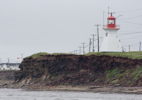
| NB 27 |
Beaver Harbour (Drew's Head)
latitude 45° 4' 9.5" N longitude 66° 44' 20.4" W
July 10, 2008
From Highway 1 take Highway 778 to Beaver Harbour, turn left at Main St., then left again at Lighthouse Road to the end (about 1 mile). The walk to the lighthouse past the red gate is about 10 minutes. (84) ARLHS # CAN-162 |
|
| NB 29 |
Pea Point |
East side of entrance to Letang Harbour. (81) ARLHS # CAN-366 |
|
|
| NB 30 |
Bliss Island
On SW point of island
South of the West entrance to Bliss Harbour (77) ARLHS # CAN-045
Photo courtesy marinas.com [marinas.com] |
|
| NB 31 |
| l'Etete Passage Green's Point)
latitude 45° 2' 19.7" N longitude 66° 53' 31.2" W
July 10, 2008
Route 1, Exit 56 or 52 then Route 172 South. Follow Deer Island ferry signs to ferry turn off then turn onto Green's Point Road and proceed 1.6 km. (71) ARLHS # CAN-214 |
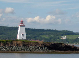
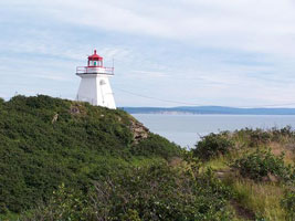
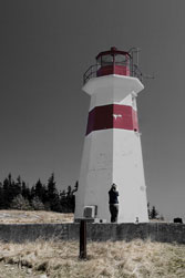
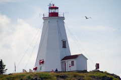
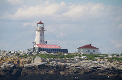
| NB 32 |
Head Harbour (East Quoddy)
latitude 44° 57' 28.4" N longitude 66° 54' W
July 10, 2008
Route 774, follow to end at East Quoddy Head. Lightstation is accessible by foot and only at low tide. Bring your passport because you need to cross from Maine back into Canada unless you arrive by ferry. (44) ARLHS # CAN-166 |
|
| NB 34 |
Southwest Wolf Island
This lighthouse can be seen distantly from the Grand Manan ferry, and it also can be seen distantly from Head Harbour. (36) ARLHS # CAN-470
Photo courtesy marinas.com [Marinas.com] |
|
| NB 35 |
| Mulholland Point
latitude 44° 51' 47" N longitude 66° 58' 44.4" W
July 10, 2008
Located on the east side of the Lubec Channel, this lighthouse can easily be seen from Maine (if the fog's not in). The first time we visited, it was pretty thick when I got up, but after breakfast, the other side was visible (if not beautifully lit).
(Take US 1 as far east as it will go, then follow State route 189 to Lubec. God willing, you will see this light.) ARLHS # CAN-326 |
| NB 36 |
Long Eddy Point
latitude 44° 47' 58.9" N longitude 66° 47' 8.2" W
July 30, 2016
The lighthouse at the end of Whistle Road, at Long Eddy Point, Island of Grand Manan, Bay of Fundy. A great place to watch sunsets.
Turn left when leaving ferry at North Head then turn right at Whistle Road and drive 4 km. (34) ARLHS # CAN-83 |
|
| NB 37 |
| Swallowtail
latitude 44° 45' 51.7" N longitude 66° 43' 56.6" W
July 30, 2016
Swallowtail Lighthouse is said to be the most photographed lighthouse on Grand Manan Island. (33) ARLHS # CAN-491 |
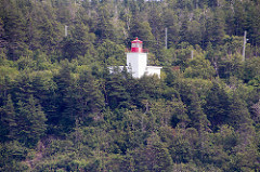
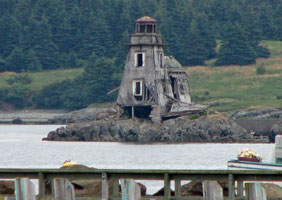
| NB 38 |
Grand Harbour (Fish Fluke Point)
This lighthouse was called the "most endangered in North America" by Lighthouse Digest. It is owned by a New York City businessman Errol Rainess. The American Lighthouse Foundation made a last-ditch effort to save the crumbling structure. Some stabilization was done to the lighthouse before the owner refused to allow anyone on the island. It is doubtful that the structure will last much longer. (19) ARLHS # CAN-709
Photo courtesy Hans Raffelt [Flickr] |
|
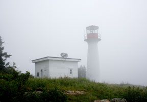
| NB 39 |
| Great Duck Island
latitude 44° 41' 3.5" N longitude 66° 41' 34.8" W
July 30, 2016
Great Duck Island is about two miles from the village of Woodward's Cove on Grand Manan and is accessible by boat only. The light has been removed in 2016 so the old picture is maintained. (29) ARLHS # CAN-210
Photo courtesy marinas.com [marinas.com] |
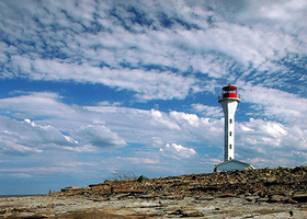
| NB 40 |
Southwest Head
latitude 44° 36' 3.9" N longitude 66° 54' 19.6" W
July 30, 2016
From ferry, follow Route 776 South, to the end of the island. (11) ARLHS # CAN-469 |
|
| NB 41 |
| Gannet Rock
latitude 44° 30' 36.8" N longitude 66° 46' 53.6" W
July 30, 2016
Accessible by boat only. Landing at Gannet Rock is very difficult. (8) ARLHS # CAN-192 |
| NB 42 |
Machias Seal Island
latitude 44° 30' 6.3" N longitude 67° 6' 6.4" W
July 30, 2016
There are two companies running bird watching cruises to Machias Seal Island from Maine; and one from Grand Manan. Captain Andrew Patterson runs trips from Cutler, Maine; call (207) 259-4484. Captain Barna B. Norton and Captain John E. Norton offer from Jonesport, Maine. Call (888) 889-3222 or (207) 497-5933. maine
Sea Watch Tours of Grand Manan also offers trips to the island. Call (506) 662-8552 or (877) 662-8552. tours (6) ARLHS # CAN-292 |
|
| NB 43 |
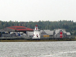
| Miramichi Estuary Ranges
There are several ranges in this Bay and river complex.
Photo courtesy hellien88 [Webshots] |
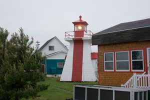
| NB 43A |
Lower Neguac Rear Range
Located off NB 11 in Lower Neguac, near the northern entrance to Miramichi Bay. The lighthouse can easily be seen from the beach. ARLHS # CAN-289
Photo courtesy hellien88 [Webshots] |
|
| NB 44 |
| Point Escuminac
This is the oldest light station on the northern coast of the province, marking the entrances to Miramachi Bay to the north and Northumberland Strait to the south. Located beyond the end of NB 117 at the end of a usually-impassable dirt road, accessible by a hike of 3 miles one way. (1163) ARLHS # CAN-389
Photo courtesy Marc Guitard [Flickr] |
| NB 44B |
Bouctouche Bar
latitude 46° 27' 40.1" N longitude 64° 36' 46.6" W |
Bouctouche Dune or Sandbar is connected to the mainland at a point roughly three-and-a-half miles north of Pointe à Jérôme and extends southeast for over seven miles, providing protection for the waters of Buctouche Bay. The southern tip of the sandbar lies about a mile off of Saint-Thomas-de-Kent, near where the Point Dixon Range Lights were established in 1881 to assist vessels in finding the entrance to the bay.
From Highway 11 in Bouctouche, take Exit 32 and travel east on Boulevard Irving. As you leave Bouctouche, the road will become Chemin Du Couvent (Route 475), which you need to follow for 9 km to reach the Irving Eco-Centre: La dune de Bouctouche. From there, it is a 22 km round trip hike out to the lighthouse. Alternatively, the lighthouse can be seen at a distance from Route 535 in Saint-Thomas-de-Kent. |
| NB 45 |
Richibucto Head (Cap Lumiere)
latitude 46° 40' 11.3" N longitude 64° 42' 43.2" W
June 27, 2008
Routes 11 and 134 to exit 57, then Route 505 to Cap-Lumière Road, then left three km to the lighthouse. (1128) ARLHS # CAN-430 |
|
| NB 46 |
| Dixon Point front range
latitude 45° 27' 22.5" N longitude 64° 39' 1" W
This light is relocated from Dixon Point and I have not been able to find it. Dixon point is Route 134 onto Route 535, in Saint Thomas. I suspect if I can find the Acadian Village, I'll find the light.
Photo courtesy bigsister861 [Webshots] |
| NB 46r |
Dixon Point rear range
latitude 45° 27' 23.4" N longitude 64° 39' 3.5" W |
Dixon Point Range Lights, put into operation on June 9, 1881, replaced a set of day beacons that had previously stood on Dixon Point. The inactive tower has since been restored and relocated to the shore, just north of the still-active front tower. |
| NB 47 |
Caissie Point
latitude 46° 19' 11.4" N longitude 64° 30' 45.6" W
June 27, 2008
The lighthouse is at the end of a road off NB 530, north of Shediac. It is private property but can be easily photographed from the road. (1113) ARLHS # CAN-090 |
|
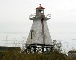
| NB 47A |
| Cocagne Front Range
latitude 46° 20' 7" N longitude 64° 36' 54.1" W
June 27, 2008
On South side of Cocagne River Mouth. ARLHS # CAN-141 |
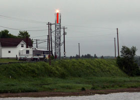
| NB 47R |
Cocagne Rear Range
latitude 46° 20' 1.2" N longitude 64° 37' 1.7" W
June 27, 2008
There is a rear range light. As you can see here,there's a reason no one talks about it. |
|
| NB 48 |
Cape Jourimain
Route 16, Exit 51, at the Cape Jourimain Interpretation Centre. Follow the Lighthouse Trail to the site, 10 minute walk. ARLHS # CAN-706
Photo courtesy Roberto Gauvin [Flickr] |
|
| NB 49 |
| Cape Tourmetine Rear Range
When the Confederation Bridge to Prince Edward Island was completed in 1997, the old Cape Tormentine Pier Range Lights were discontinued. This is the rear range light and it is on private property and difficult to access.
Photo courtesy big sister [Webshots] |
| NB 49F |
Cape Tourmetine Front Range
latitude 46° 8' 5.7" N longitude 63° 46' 21.3" W
Local fishermen wanted the front light back in operation and it was reactivated in the late 1990s. The light is on the dock.
Photo courtesy Dennis Jarvis [Flickr] |
|
| NB 49P |
| Pointe-du-Chêne Wharf
latitude 46° 14' 26.1" N longitude 64° 31' 50.2" W
Pointe-du-Chêne is a small community in Westmorland County, New Brunswick. Located on Shediac Bay, an inlet of the Northumberland Strait, Pointe-du-Chêne, also called La Pointe, is the home of Parlee Beach Provincial Park. It was once the terminus of the European and North American Railway and was a key stopover for Pan-Am's Trans Atlantic air service inaugurated in 1939.
Photo courtesy Shawn Harquall [Flickr] |
| NB 50 |
Indian Point Front Range Light |
The Indian Point lights were the last set to be built to assist Ferrys into and out of this treacherous waterway. These were built in 1950 and are no longer in service. |
| NB 51 |
Indian Point Rear Range Light |
This is the rear range matching the light above. |
|
|
If you would like copies of my pictures, contact me and we'll discuss arrangements. There are others who do this commercially, I have no intention of competing directly, but you can make a proposal, and I'll react. If you've read this far, you've probably figured out that I personally have only visited a few of the lights on this page. If you have done so, and have updates to this page, please contact me so we can fix things. MailMe
 St. Lawrence River
 Québec