|
This page currently shows the Lighthouses of Washington (state, not DC). Lights are numbered from the north to the south (clockwise around Puget Sound). I am very grateful to Lighthouse Friends for their excellent data on location and directions to lights. Each lighthouse is linked to (in our editorial opinion) the best reference site for that light. friends |
|
WA 1
[14] |
Patos Island
latitude 48° 47' 20.6" N longitude 122° 58' 16" W
access: boat
Paraclete Charters offers occasional public trips to Patos Island. paraclete ARLHS # USA-584
Photo courtesy morreya [webshots] |
|
WA 2
[13] |
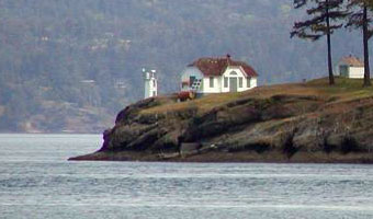
| Turn Point , Stuart Island
latitude 48° 41' 19.3" N longitude 123° 14' 13.9" W
access: boat, 2 mile walk
Stuart Island can be reached by boat most easily from Sidney on Vancouver Island or from Friday Harbor on San Juan Island. One can charter a float plane out of Sidney to view the lighthouse. A public boat dock is available at Prevost Harbor, from where it is a two-mile hike to the lighthouse. ARLHS # USA-858
Photo courtesy Ron Mielke [webshots] |
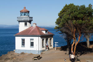
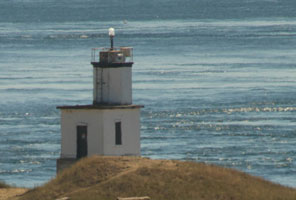
WA 3
[11] |
Lime Kiln , San Juan Island
latitude 48° 30' 57.1" N longitude 123° 9' 9.4" W
September 12, 2014 access: car ferry
Friday Harbor on San Juan Island can be reached by Washington State Ferry from Anacortes, which is roughly 75 miles north of Seattle. For ferry schedules, see the Washington State Ferry website. ferry
Once in Friday Harbor, follow Spring Street west out of the town. Spring Street will become San Juan Valley Road. From San Juan Valley Road, turn left on Douglas Road and drive 1.7 miles to Bailer Hill Road. Turn right on Bailer Hill Road and drive roughly four miles, where it will turn into Westside Road. Follow Westside Road 1.5 miles to Lime Kiln State Park. ARLHS # USA-433 |
|
WA 4
[12] |
| Cattle Point , San Juan Island
latitude 48° 27' 2.3" N longitude 122° 57' 47.8" W
September 12, 2014 access: car ferry + walk
Friday Harbor on San Juan Island can be reached by ferry from Anacortes, which is roughly 75 miles north of Seattle. ferry
Once in Friday Harbor, follow Spring Street west out of the town. Spring Street will become San Juan Valley Road. From San Juan Valley Road, turn left on Douglas Road and drive 1.5 miles to Little Road. Turn left on Little Road and drive 0.4 miles where it ends. Turn right on Cattle Point Road and drive roughly 6 miles to the southern end of the island. The lighthouse can be viewed from the top of the hill. If you wish to walk to the light, go to a narrow pullout at the bottom of the hill and follow the trail from there. ARLHS # USA-146 |
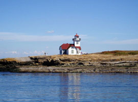
WA 5
[15] |
Burrows Island
access: ferry, kayak
A distant view of the lighthouse is possible from the ferries from Anacrotes to the San Juan Islands. Look south with your binoculars shortly after the ferry departs Anacortes. A closer view of the lighthouse can be had by taking a Burrows Island Kayak Tour. tour ARLHS # USA-098
Photo courtesy crimsontusker [webshots] |
|
WA 6
[1] |
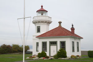
| Mukilteo
latitude 47° 56' 55.3" N longitude 122° 18' 22.4" W
September 28, 2012 access: ferry
From Interstate 5 roughly 20 miles north of Seattle, take Highway 525 and follow it to the Whidbey Island Ferry Landing in Mukilteo. The lighthouse is next to the landing. ARLHS # USA-517 |
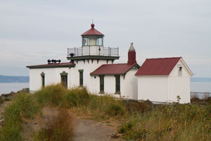
WA 7
[3] |
West Point
latitude 47° 39' 43" N longitude 122° 26' 8.5" W
September 28, 2012 access: walk (2 mile)
Go to Discovery Park in Seattle. Only handicapped parking is permitted at the lighthouse. From the Discovery Park Visitor Center it is just under a two-mile walk to the lighthouse. You can also park at the "no vehicles past here" sign which is about 1.2 miles and an easy walk. park (G 4861) ARLHS # USA-878 |
|
WA 8
[4] |
| Alki Point
latitude 47° 34' 34.6" N longitude 122° 25' 13.8" W
September 16, 2012 access: car
From Highway 99 south of Seattle, take Spokane Street west across the two bridges. Turn right onto Harbor Avenue, which after a while will become Alki Avenue, and follow it around the edge of the bay to the lighthouse.
The keeper's house is now a private residence, the rest is an operational Coast Guard Station. Thus access is pretty much impossible except weekends from Memorial Day to Labor Day when docents are present on Saturdays and Sundays. ARLHS # USA-005 |
|
|
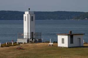
WA 9
[5] |
Point Robinson
access: car
Located on the northeast corner of Maury Island in Puget Sound, the lighthouse marks the halfway point between Seattle and Tacoma.
From the ferry landing on the southern end of Vashon Island, go north on Vashon Island Highway, the main north-south road on the island, for 5.7 miles to Quartermaster Drive (225th Street). Turn right on Quartermaster Drive and drive east for 1.4 miles where the road will fork. Take the right fork, Dockton Road, drive 0.4 miles and then turn left onto Point Robinson Road. Follow this road for 1.7 miles where it will connect with 240th Street. After these roads meet, continue east 1.7 miles to the lighthouse. ARLHS # USA-637
Photo courtesy Ann Shelton [webshots] |
|
WA 10
[6] |
| Brown's Point
latitude 47° 18' 21.3" N longitude 122° 26' 39.5" W
September 16, 2012 access: car
From I-5 east of Tacoma, take Exit 136 and go north on Port of Tacoma Road. Turn right onto Highway 509 and continue for seven miles. Turn left on Le Lou Wa Pl and continue on Tok A Lou Avenue to the lighthouse. ARLHS # USA-089 |
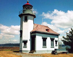
WA 11
[7] |
Dofflemeyer Point
latitude 47° 8' 26" N longitude 122° 54' 26.7" W
September 27, 2012 access: car
Located in Boston Harbor north of Olympia, marking the entrance to Budd Inlet.
From downtown Olympia, follow East Bay Drive north along the east edge of Budd Inlet. East Bay Drive will become Boston Harbor Road, which you will follow to Boston Harbor. Once in Boston Harbor, turn west on 73rd Avenue. The lighthouse is located near the end of 73rd Avenue. Access from land may be restricted. ARLHS # USA-232 |
|
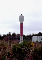
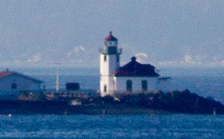
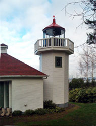
WA 12
[6.6] |
| Gig Harbor
latitude 47° 19' 35.6" N longitude 122° 34' 29.1" W
September 16, 2012 access: car
The lighthouse was built as a civic project honoring the 200th anniversary of the U.S. lighthouse establishment, it replaced a small post light. Located on the spit at the harbor entrance, take Crescent Valley Dr. to the end of Goodman Drive NW.
Buried behind private property, it is very difficult to photograph. ARLHS # USA-1064 |
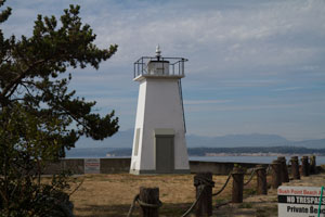
WA 13
[2] |
Point No Point
latitude 47° 54' 42.9" N longitude 122° 31' 39.8" W
September 16, 2012 access: car
From Highway 104, go north on Hansville Road. After approximately 6 miles on this road, turn right on Point No Point Road and follow it to the lighthouse at its end. (G 4828) ARLHS # USA-631 |
|
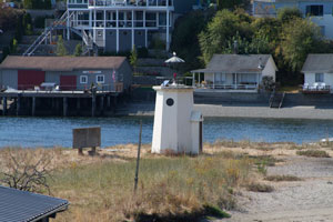
WA 14
[1.8] |
| Skunk Bay
access: car
This lighthouse was built by author Jim Gibbs, a former lighthouse keeper, using plans of the Mukilteo Light. Gibbs, who lives now in Oregon, sold the lighthouse in 1971 to a group of his former neighbors, who maintain it as a private clubhouse. Located one mile west of Hansville off Twin Spits Road on Skunk Bay, a bight of Admiralty Inlet. (G 4810) ARLHS # USA-965
Photo courtesy Darlene Cook [Flickr] |
|
|
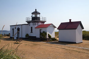
WA 15
[8.2] |
Bush Point
latitude 48° 1' 51.1" N longitude 122° 36' 32.4" W
September 28, 2012 access: car
The passage between Bush Point on Whidbey Island and Marrowstone Island is the narrowest one in North Puget Sound and was first marked by a private light maintained by the Farmer family, early settlers of Bush Point.
Take the ferry to Whidbey Island, head west to Bush Point Road west of Freeland, exit onto Scurloch road, then take Fair Haven drive down to the bottom. The light is on private land but photos from the public road are welcomed. (G 4803) ARLHS # USA-1063 |
|
WA 16
[8] |

| Admiralty Head
latitude 48° 9' 17.3" N longitude 122° 40' 40.4" W
September 28, 2012 access: car ferry
Two points define the entrance to Admiralty Inlet from the Strait of San Juan de Fuca: Point Wilson on the west and Admiralty Head on the east. park
From the intersection of Highways 525 and 20 on Whidbey Island, go west on Highway 20 for roughly four miles. Shortly after you pass the Keystone ferry landing, you will come to Fort Casey State Park. The lighthouse is in the southwest corner of the park. (G 4784) ARLHS # USA-002 |
WA 17
[10] |
Marrowstone Point
latitude 48° 6' 1.6" N longitude 122° 41' 21.9" W
September 16, 2012 access: car
Marrowstone Point forms the eastern entrance to Port Townsend Bay and was first marked by a lens lantern on a pole on October 1, 1888, around the time when several such aids were established on Puget Sound. Fort
Take Highway 116, also known as Flagler Road, onto Indian Island and then to Marrowstone Island. Follow the road to Fort Flagler State Park. The lighthouse is on the northeastern tip of the island. (G 4802) ARLHS # USA-478 |
|
WA 18
[9] |
| Point Wilson
latitude 48° 8' 39" N longitude 122° 45' 17.1" W
September 16, 2012 access: car
From Highway 20 in Port Townsend, turn left on Kearney Street and when it ends turn right onto Blaine Street. From Blaine Street, turn left onto Walker Street, which will become Cherry Street. Follow Cherry Street 1.6 miles to Fort Worden where the road changes to Fort Worden Way. Enter Fort Worden and turn right on Eisenhower Avenue. When Eisenhower Avenue ends, turn left on Harbor Defense Way and follow it 0.8 miles to the lighthouse. ARLHS # USA-641 |
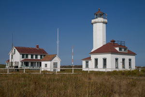
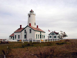
WA 19
[16] |
New Dungeness
latitude 48° 10' 54.3" N longitude 123° 6' 35.4" W
access: car + view or 5 mile hike
From Highway 101 in Sequim, take the Seqim Avenue exit and go north on Sequim Avenue which will become Sequim Dungeness Way and follow it to its end. From there you can get a view of the lighthouse at the end of the spit across Dungeness Bay. If you want to hike to the lighthouse, take Kitchen-Dick Road north from Highway 101 on the west side of Sequim and follow it to the Dungeness Recreation Area. From there, it is about a 5-mile hike to the lighthouse. (G 4772) ARLHS # USA-538
Photo courtesy harmer39 [webshots] |
|
WA 20
[17] |
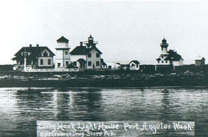
| Ediz Hook , Port Angeles
latitude 48° 6' 45.1" N longitude 123° 25' 38.1" W
September 17, 2012 access: car
From Highway 101 in Port Angeles, turn south on Albert Street and follow it to Fourth Street, where you will see the house that was the Ediz Hook Lighthouse.
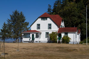
The light has been moved to Port Angeles (location expected to be the museum, but not confirmed.) ARLHS # USA-266
Photo courtesy the Archives of Elinor DeWire. [WAlightkeepers] |
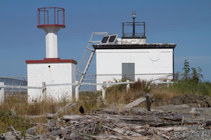
WA 21
[18] |
Slip Point
latitude 48° 15' 37.6" N longitude 124° 15' 5.8" W
September 17, 2012 access: car
(dismantled, now a light and fog signal 12 miles east.)
From Highway 101 on the Olympic Peninsula, take Highway 113 north to Highway 112. Follow Highway 112 west into Clallam Bay. In Clallam Bay, turn right onto Frontier Street. Frontier Street will turn into Salt Air Street near the beach where you will find the keeper's dwelling. The lighthouse was located north of the keeper's quarter along the beach. ARLHS # USA-762 |
|
WA 22
[23] |
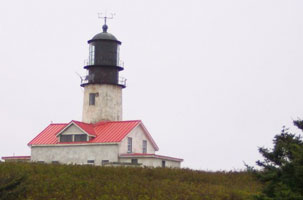
| Cape Flattery , Tatoosh Island
latitude 48° 23' 29.7" N longitude 124° 44' 11.1" W
September 17, 2012 access: car + view or boat
From Highway 101 in the northwestern part of the Olympic Penninsula, take Highway 113 north to Highway 112. Follow Highway 112 west to Neah Bay home of the Makah Indian Reservation. Proceed west out of Neah Bay to the Cape Flattery Trail which is located approximately 8 miles west of Neah Bay. The Cape Flattery walking trail leads 0.75 miles down to to the tip of the cape (and a similar distance up), where there are multiple observation platforms from which you can view Tatoosh Island and the lighthouse It took us about 1 hour round-trip. trail (G 4756) ARLHS # USA-117 |
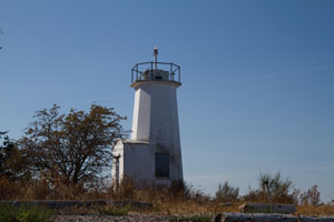
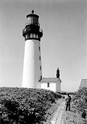
WA 23
[22] |
Destruction Island
latitude 47° 41' 24.5" N longitude 124° 24' 35.5" W
September 17, 2012 access: boat
Located on Destruction Island, which is three miles offshore from a point on the Olympic Peninsula roughly half way between Cape Flattery and Grays Harbor. The lighthouse on Destruction Island can be viewed from turnouts along Highway 101 in Olympic National Park. Highway 101 hugs the Pacific Ocean for about twelve miles through Olympic National Park from Queets to Ruby Beach. The best viewpoints are two miles south of Ruby Beach. ARLHS # USA-225
Photo courtesy public domain of the National Park Service [wikipedia] |
|
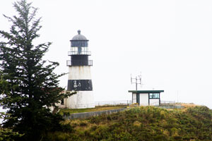
WA 24
[21] |
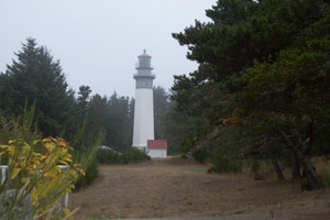
| Gray's Harbor (a.k.a. Westport)
latitude 46° 53' 16.1" N longitude 124° 7' 1.1" W
September 18, 2012 access: car
From Highway 101 near Aberdeen, take Highway 105 west for roughly 20 miles. Where Highway 105 tees, turn right and go north for two miles on Highway 105, also known as Forest Avenue, to Ocean Avenue and turn left. The lighthouse is located 0.2 miles down Ocean Avenue on the right hand side. (G 4726) ARLHS # USA-342 |
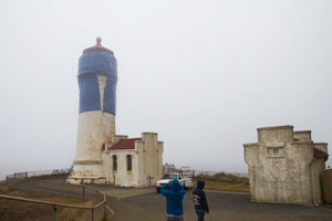
WA 25
[20] |
North Head
latitude 46° 17' 56" N longitude 124° 4' 40.9" W
September 18, 2012 access: car
From Ilwaco, take Highway 100 south towards Cape Disappointment State Park. After about 1.5 miles, turn right onto Rober Gray Drive and follow it for less than a mile to North Head Lighthouse Drive. The lighthouse is located at the end of North Head Lighthouse Drive. park
A unique photo as the head will be buried in the tarp for only 15 days. (G 4718) ARLHS # USA-553 |
|
WA 26
[19] |
| Cape Disappointment
latitude 46° 16' 33" N longitude 124° 3' 7.2" W
September 18, 2012
From Ilwaco, follow Highway 100 south into Fort Canby State Park. Parking is available near the Lewis and Clark Interpretive Center, from which a trail leads up a high bluff to the lighthouse. park (G 4532) ARLHS # USA-112 |
WA 27e
[27.1] |
| Willapa Bay
Photo is an early light
Photo courtesy US Coast Guard Archives. |
|
|
 British Columbia