|
This page currently shows the Lighthouses of British Columbia. As with many other pages, I am in debt to Russ Rowlett for his Lighthouse Directory . Each lighthouse is linked to (in our editorial opinion) the best reference site for that light. directory This numbering goes North to South down the inside channel, then loops back north again on the western edge of the islands |
|
| BC 1 |
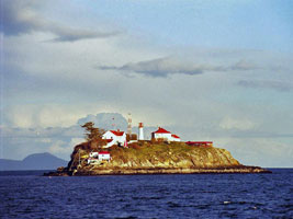
Green Island
Located on a small island off the northeastern tip of Dundas Island, about 40 km northwest of Prince Rupert and about 5 km south of the Alaskan border. Accessible only by boat. ARLHS # CAN-742
Photo courtesy filo1000 [Flickr] |
|
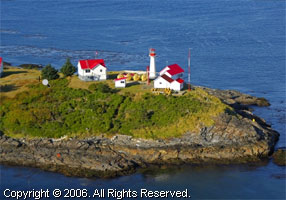
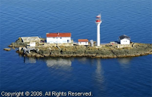
| BC 2 |
| Lucy Island
Located at the northeastern tip of the islands, about 15 km west of Prince Rupert, marking the start of the Metlaketla Channel leading to Prince Rupert Harbour. Accessible only by boat. ARLHS # CAN-290
Photo courtesy smell & quiet [Flickr] |
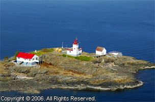
| BC 3 |
Triple Island
Located on the northwestern most of three rocky islets in the Brown Passage about 40 km west of Prince Rupert. Accessible only by boat in dangerous seas or by helicopter. (G 5812) ARLHS # CAN-508
Photo courtesy smell & quiet [Flickr] |
|
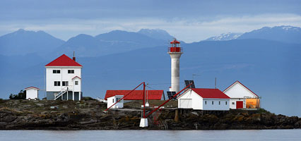
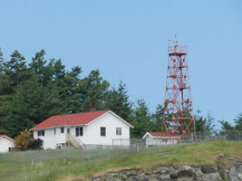
BC 4
[5] |
Barrett Rock |
Barrett Rock Light is near Kaien Island a few miles south of Prince Rupert. The lightkeeper's house was about 100 yards away, beside the railroad tracks. ARLHS # CAN-020 |
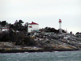
BC 5
[6] |
Holland Rock
latitude 54° 10' 20.2" N longitude 130° 21' 39.4" W
The original lighthouse was destroyed by fire in 1946. Located on an isolated rock in Chatham Sound about 15 km south of Prince Rupert. (G 5772) ARLHS # CAN-229
Photo courtesy Günther Hess [ListOfLights] |
|
BC 6
[7] |
Lawyer Island |
The historic lighthouse at this site is gone, the skeletal tower remains a landmark for travelers on the Inside Passage. Located on an island about 25 km south of Prince Rupert. ARLHS # CAN-272 |
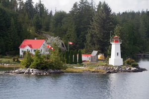
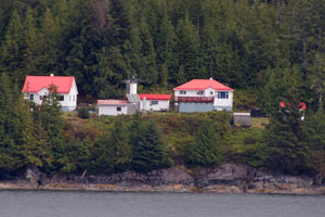
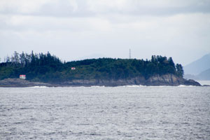
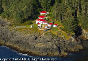
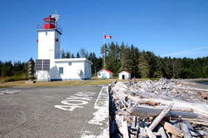
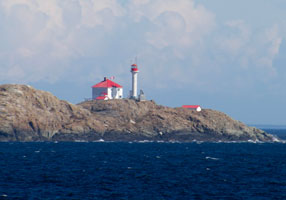
BC 7
[9] |
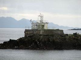
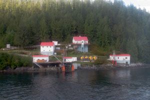
Boat Bluff
latitude 52° 38' 35.6" N longitude 128° 31' 27.9" W
August 30, 2014
Located directly on the Inside Passage on the west side of Sarah Island, marking the northbound entrance to the narrow Sarah Passage, about 5 km north of the village of Klemtu. Accessible only by boat, but easily seen from passing ships. (G 5750) ARLHS # CAN-048 |
|
BC 8
[10] |
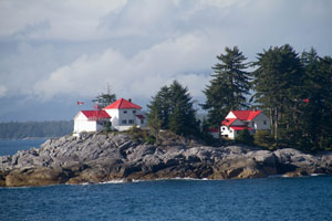
| Ivory Island
latitude 52° 16' 10.3" N longitude 128° 24' 25.7" W
August 30, 2014
Located on the south side of the island in the entrance to the Seaforth Channel from Milbanke Sound, about 15 miles northwest of Bella Bella. (G 5713) ARLHS # CAN-252 |
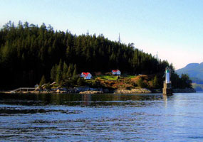
BC 9
[11] |
McInnes Island
Located on the south side of a small island off the southern tip of Price Island, marking the northern entrance to Milbanke Sound about 50 km west of Bella Bella (this is about 13 km southeast of the Inside Passage route). (G 5715) ARLHS # CAN-310
Photo courtesy Rainer Arndt [ListOfLights] |
|
BC 10
[12] |
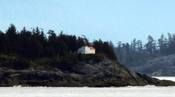
| Dryad Point
latitude 52° 10' 26.2" N longitude 128° 7' 10.5" W
August 30, 2014
Located on the northeast point of Campbell Island about 3 km north of Bella Bella. (G 5700) ARLHS # CAN-163 |
BC 12
[15] |
Addenbroke Island
latitude 51° 36' 12.1" N longitude 127° 51' 49.7" W
August 30, 2014
The original lighthouse was replaced by a steel skeletal tower about 1968. That tower still stands, along with the active light. Located on an island in Fitzhugh Sound, on the east side of Calvert Island about 100 km north of Port Hardy and a similar distance southwest of Bella Coola.
Visible from the Alaska Marine Highway ferry (G 5672) ARLHS # CAN-004 |
|
BC 13
[16] |
| Egg Island
August 30, 2014
The 1898 lighthouse was destroyed by a tsunami on November 2, 1948. The new skeletal tower is located on the island at the top of the hill about 10 km north of Cape Caution on the eastern shore of Queen Charlotte Sound. (G 5658) ARLHS # CAN-740 |
BC 14
[17] |
Pine Island
Located on a small island in the middle of the entrance to Queen Charlotte Strait from Queen Charlotte Sound. (G 5649) ARLHS # CAN-382
Photo courtesy marinas.com [marinas.com] |
|
BC 15
[19] |
| Scarlett Point
latitude 50° 51' 37.3" N longitude 127° 36' 45.4" W
Located on the northeastern point of Balaklava Island, an island off the north coast of Vancouver Island about 15 km northwest of Port Hardy. (G 5648) ARLHS # CAN-450
Photo courtesy marinas.com [marinas.com] |
|
|
BC 16
[21] |
Pulteney Point (Sointula)
latitude 50° 37' 49.9" N longitude 127° 9' 18.9" W
The light is on Malcolm Island (near Alert Bay).
Sointula is a small town near the northern tip of Vancouver Island, founded during the turn-of-the-century by Finnish Utopian socialists. (G 5628) +
Photo courtesy Jeff Werner [Flickr] |
|
BC 17
[23] |
| Chatham Point
This is more a weather station, but there is a light here as well. Located about 40 km north of Campbell River on the west side of the Inside Passage, where the route takes a sharp turn from the Discovery Passage into the Johnstone Strait. Land access from Chatham Point Road is probably closed to the public, so the light is best seen by boat. (G 5590) ARLHS # CAN-132
Photo courtesy Jeffrey James [ListOfLights] |
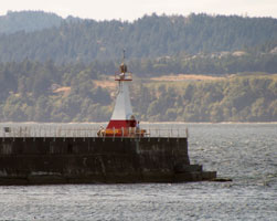
BC 18
[24] |
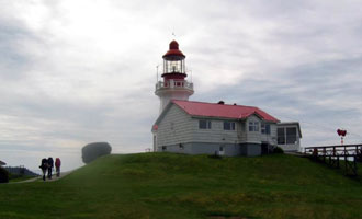
Cape Mudge (Quadra Island)
latitude 49° 59' 54.4" N longitude 125° 11' 44.2" W
Quadra Island is reached by a short ferry ride from Campbell River. The light station is located at the south end of the island. To get there, leave the Quathiaski Cove ferry terminal on Heriot Bay Road, turn south on Cape Mudge Road, then follow Lighthouse Road to the lighthouse. (G 5580) ARLHS # CAN-100
Photo courtesy Cathy Vanderwyst [webshots] |
|
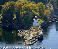
BC 19
[28] |
| Chrome Island (Yellow Island)
Located on a small island just off Boyle Point, the southern point of Denman Island about 1.5 km east of Deep Bay; there is an excellent view of the light station from Boyle Point Provincial Park. park ARLHS # CAN-137
Photo courtesy sorenson1 [webshots] |
BC 20
[27] |
Sisters Island
latitude 49° 29' 11.1" N longitude 124° 26' 6" W
Located on a small island in the middle of the Strait about 15 km north of Qualicum Beach. Accessible only by boat. (G 5529) ARLHS # CAN-462
Photo courtesy marinas.com [marinas.com] |
|
BC 21
[29] |
| Merry Island
latitude 49° 28' 3.1" N longitude 123° 54' 43.6" W
Except for the light station, the island is privately owned. Located on the southern end of the island about 5 km south of the town of Halfmoon Bay on the mainland side of the Strait. ARLHS # CAN-314
Photo courtesy marinas.com [marinas.com] |
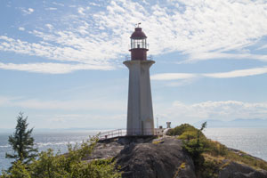
BC 22
[32] |
Point Atkinson
latitude 49° 19' 49.3" N longitude 123° 15' 52.3" W
August 27, 2014
To get to the Lighthouse Park in West Vancouver, drive along Marine Drive to the west end of the 4900 block and turn south on Beach Lane. To reach the lighthouse, walk down the main trail about 800 metres. (G 5426) ARLHS # CAN-387 |
|
BC 23
[34] |
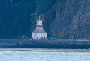
| Prospect Point
August 27, 2014
The Prospect Lighthouse located in Vancouver's Stanley Park, just a short distance west of the Lion's Gate Bridge.
Since it is directly below the bridge, it is best viewed from West Vancouver in Ablestone park. (G 5434) ARLHS # CAN-1308 |
BC 24
[33] |
Capilano
latitude 49° 18' 41.3" N longitude 123° 7' 4.5" W
August 27, 2014
This light is on the north side of the entrance to Vancouver Harbour. This lighthouse was replaced by a light on a concrete structure in 1969. The 1915 lighthouse was burned down in February 1969.
The light can be seen from Ablestone park. ARLHS # CAN-115 |
|
BC 25
[35] |
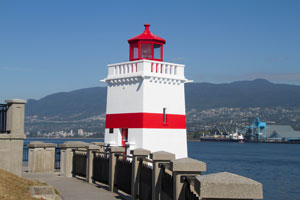
| Brockton Point
latitude 49° 18' 3.2" N longitude 123° 7' 1.2" W
August 27, 2014
The Brockton Point Lighthouse is located in Stanley Park at Brockton Point. It can be reached by car along the park drive, about two kilometers from the Park entrance. ARLHS # CAN-060 |
BC 26
[39] |
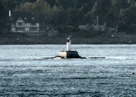
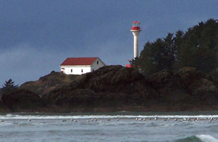
Sand Heads |
Located on an island at the entrance to Clayoquot Sound. Accessible only by boat, visible distantly from Tofino at the end of BC 4. ARLHS # CAN-446 |
BC 27
[31] |
Ballenas Island
Except for the light station, the island is privately owned. Located on the north point of North Ballenas Island in the Strait about 8 km east of Parksville. Accessible only by boat. ARLHS # CAN-018
Photo courtesy marinas.com [marinas.com] |
|
BC 28
[36] |
| Entrance Island
Located on a small island off the mouth of Nanaimo Harbour, about 13 km east of the city. (G 5488) ARLHS # CAN-171
Photo courtesy John Alexander [Flickr] |
BC 29
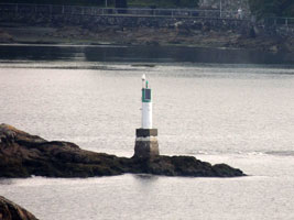
[37] |
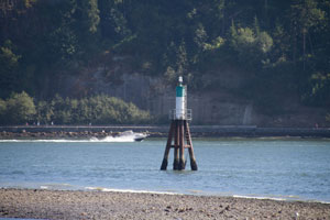
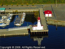
Gallows Point
latitude 49° 10' 12.3" N longitude 123° 55' 4.5" W |
Located at the south end of Protection Island (in Nanaimo Harbour). This is a small white [offshore] beacon. ARLHS # CAN-191 |
|
|
BC 30
[40] |
Porlier Pass (Virago Point)
Located at the northwest end of Galiano Island, which is accessible by ferry from several locations. ferry
This is technically the Rear Range and is no longer in service. The Front Range is at Race Point (CAN-1130) ARLHS # CAN-403
Photo courtesy marinas.com [marinas.com] |
|
BC 32
[43] |
Active Pass (Georgina Point, Mayne Island)
latitude 48° 52' 26" N longitude 123° 17' 30.7" W
August 28, 2014
Viewed by hundreds of people every day from the ferries that run between Tsawwassen on the BC mainland to Swartz Bay (Victoria) on Vancouver Island.
The light is on the north point of Mayne Island (thus on the Port side of the Victoria bound ferry.) (G 5360) ARLHS # CAN-002 |
|
BC 33
[44] |
| Portlock Point
latitude 48° 51' 27.2" N longitude 123° 20' 43.9" W
August 28, 2014
A beautiful lighthouse which can be seen on the Tswaassen(Vancouver)/Swartz Bay(Victoria) Ferry route. For more information follow this link (G 5368) ARLHS # CAN-411 |
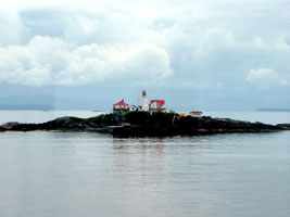
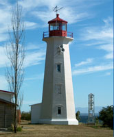
BC 34
[46] |
Saturna Island (East Point)
Located, as its name implies, at the eastern end of Saturna Island, the junction of the Haro Strait and the Strait of Georgia. Recent reports imply that the tower has been demolished leaving only the fog signal building. (G 5358) ARLHS # CAN-448
Photo courtesy Mike Boucher [ListOfLights] |
|
BC 35
[51] |
| Discovery Island
latitude 48° 25' 28" N longitude 123° 13' 32.4" W
Access is mostly by sea kayak, as there is no protected landing for boats. Located at Sea Bird Point on the eastern end of the island about 5 km east of Victoria, marking the junction of the Haro Strait and the Straight of Juan de Fuca. ARLHS # CAN-160
Photo courtesy Ron Mielke [webshots] |
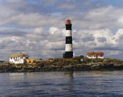
BC 37
[53] |
| Trial Island
latitude 48° 23' 45.6" N longitude 123° 18' 17" W
August 28, 2014
Located at the south end of Trial Island marking the western entrance to Victoria Harbour. Accessible only by boat; visible distantly from Beach Drive near Anderson Hill Park in the southern part of Victoria. (G 5328) ARLHS # CAN-506 |
BC 38
[52] |
Berens Island
Located at the Entrance of Victoria Harbour. The light is now operating only as an aeronautical beacon. (G 5312.4) ARLHS # CAN-032
Photo courtesy Rainer Arndt [ListOfLights] |
|
BC 38P
[52] |
| Ogden Point Breakwater
latitude 48° 24' 48.5" N longitude 123° 23' 37.7" W
August 28, 2014
The Ogden Point Breakwater protects the outer harbor where the cruise ships dock. It's about a 15 minute walk from the legislature downtown (Belleville Street to Oswego, left to the water, then right.) It's about another kilometer out to the light. (G 5312) |
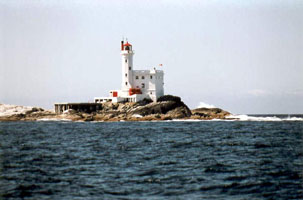
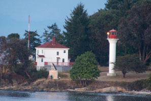
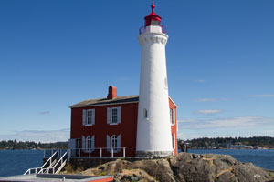
BC 39
[49] |
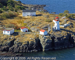
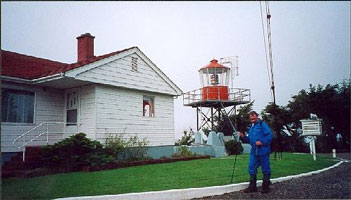
Fisgard
latitude 48° 25' 49.7" N longitude 123° 26' 51.4" W
August 28, 2014
This is the oldest light in Western Canada
Located on a small island, connected to the mainland by a causeway, at the western entrance to Esquimalt Harbour, off Ocean Boulevard in Belmont Park west of Victoria. (G 5306) ARLHS # CAN-176 |
|
BC 41
[56] |
Race Rock (Great Race Rock)
Located on Great Race Rock, a small island in the Strait of Juan de Fuca about 15 km southwest of Victoria. Special permission is required to land on the island. (G 5300) ARLHS # CAN-426
Photo courtesy CW Hendricks [webshots] |
|
BC 42
[55] |
| Sheringham Point
latitude 48° 22' 36.3" N longitude 123° 55' 15.7" W
Located on a rocky promontory at the end of Sheringham Point Road off BC 14 in Shirley, about 16 km west of Sooke. (G 5292) ARLHS # CAN-458
Photo courtesy Sooke Photos [webshots] |
BC 43
[48] |
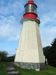
Carmanah Point
The original lighthouse was a square wood tower attached to the keeper's house. Located on the West Coast Trail in the Pacific Rim National Park Reserve about 20 km northwest of the Gordon River Trailhead near Port Renfrew. park ARLHS # CAN-120
Photo courtesy trilliumbc [webshots] |
|
BC 44
[47] |
| Pachena Point
latitude 48° 43' 19.4" N longitude 125° 5' 51.3" W
A historic station, little changed in a almost a century. Located on the West Coast Trail in the Pacific Rim National Park Reserve about 15 km south of Bamfield park ARLHS # CAN-362
Photo courtesy trilliumbc [webshots] |
BC 45
[47] |
Cape Beale
latitude 48° 47' 11.3" N longitude 125° 12' 59" W
Accessible via hiking trails leading from the area of Bamfield. Keepers sometimes will accompany visitors in climbing the tower. bamfield ARLHS # CAN-091
Photo courtesy Clay Dean [Flickr] |
|
BC 46
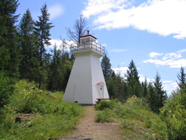
[31P] |
| Port Alberni Martime Discovery Centre
latitude 49° 13' 52.6" N longitude 124° 48' 50.1" W
This lighthouse was relocated here from a coastal location. Located on an elbow of the quay of the small boat harbor in Port Alberni, at the head of the Alberni Inlet (fjord).
Photo courtesy marinas.com [marinas.com] |
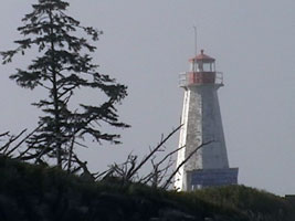
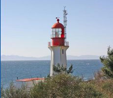
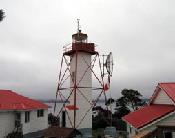
BC 48
[42] |
Amphitrite Point
near Ucluelet on the West Coast of Vancouver Island. (G 5246) ARLHS # CAN-010
Photo courtesy slaviks [webshots] |
|
BC 49
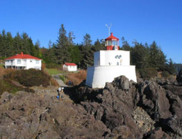
[38] |
| Lennard Island
Located on an island at the entrance to Clayoquot Sound. Accessible only by boat, visible distantly from Tofino at the end of BC 4. ARLHS # CAN-273
Photo courtesy Phototrain [Flickr] |
BC 50
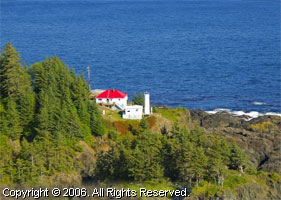
[30] |
Estevan Point |
Estevan Point is an active Coast Guard station with half a dozen red-roofed buildings and several communication towers. The lighthouse marks a prominent headland about 30 km south of Nootka Light. Accessible only by boat. |
BC 51
[26] |
Nootka
Located at the southeastern tip of Nootka Island marking the northern entrance to Nootka Sound. The station is adjacent to the Native American settlement of Yuquot, which is accessible in the summer by tour boat or by water taxi from Gold River at the end of BC 28.
Photo courtesy brown [webshots] |
|
BC 52
[26] |
| Quatsino (Kains Island)
Located on Kains Island at the entrance to Quatsino Sound about 55 km southeast of Cape Scott. Accessible only by boat.
Photo courtesy marinas.com [marinas.com] |
BC 53
[20] |
Cape Scott
The last leg of the hike to reach Cape Scott Lighthouse starts at the west end of Nels Bight and is a 16 km return hike. This trail that leads to Experiment Bight, Guise Bay and the cape, follows an old jeep road that dates back to World War Two, when a radar station operated in this area. Here the Sand Neck is so narrow that from a height of land you can see both the east side and the west side of Vancouver Island. From Guise Bay, there’s a plank road that leads up to Cape Scott Lighthouse. |
|
BC 54
[18] |
Triangle Island |
The island has large seabird populations and is now the Anne Vallee Provincial Ecological Reserve. Located atop an island about 50 km northwest of Cape Scott, Vancouver Island. Accessible only by boat in dangerous seas. |
BC 55
[14] |
Cape St. James |
On St. James island which is at the extreme southern end of the Queen Charlotte Islands. The lantern was removed in 1958 and all that exists now is a skeletal tower. lantern |
BC 56
[14] |
Bonilla Island |
This is British Columbia's newest light station. Located on an island off the northwestern tip of Banks Island, marking the southern entrance to Hecate Strait and the Prince Rupert area. |
BC 57
[4] |
Langara Point
latitude 54° 15' 19.6" N longitude 133° 3' 34" W |
Langara Fishing Adventures offers tours to the island, including visits to the light station. tours
Located at the northern tip of Langara Island at the extreme northern end of the Queen Charlotte Islands, marking the south side of the Dixon Entrance. |
BC 58
[25] |
Pilot Bay (relocated)
latitude 49° 38' 19.8" N longitude 116° 53' 4.4" W
The park is off Highway 3A south of Crawford Bay, BC. At the Kootenay Bay ferry terminal, drive south on Pilot Bay Road for 5 km to the road's end and trailhead. It is an easy walk of about 10 minutes to the Pilot Bay Lighthouse.
Photo courtesy Allyson Kenning [Flickr] |
|
|
|
If you've read this far, you've probably figured out that I personally have not visited any of the lights on this page. If you have done so, and have updates to this page, please contact me so we can fix things. mailMe
 Alaska