|
This page shows the documentation of the Lighthouses of Eastern Sweden. You can always click on the photo of the light to go to a specific (larger resolution) copy. Each lighthouse name is linked to (in our editorial opinion) the best reference site for that light. This list was built based on the list maintained by the Amateur Radio Lighthouse Society. My thanks to them for providing this basis for understanding. w8 I would like to include directions on how to get to these lights. If you know such data, could you eMail me and I'll post it here (with your choice of attribution.) mailme There has been significant usage of the Lighthouse Directory prepared by Russ Rowlett (UNC). My thanks to him for providing this basis for understanding. LHdirectory |
|
Gävleborgs Län
| SW 64 |
Balsø |
ARLHS # SWE-003 |
| SW 65 |
Hølick |
ARLHS # SWE-196 |
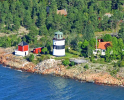
| SW 66 |
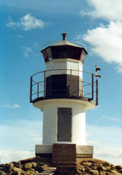
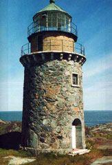
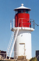
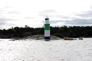
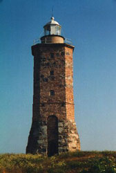
Agö I
latitude 61° 32' 32.3" N longitude 17° 27' 56.6" E
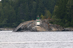
A stone (white) tower attached to a dwelling located on the eastern tip of Agö (Agön) island in the Gulf of Bothnia. ARLHS # SWE-001
Photo courtesy Esbjörn Hillberg (Swedish Lighthouse Society) [fyr] |
|
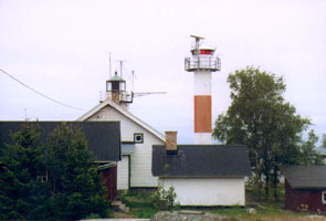
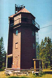
| SW 67 |
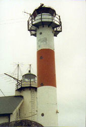
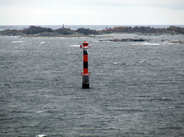
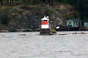
| Agø II
latitude 61° 32' 32.4" N longitude 17° 27' 58.4" E
Clearly, it is quite difficult to get a photo of one of these lights, without also getting the other. ARLHS # SWE-078
Photo courtesy Esbjörn Hillberg (Swedish Lighthouse Society) [fyr] |
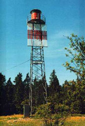
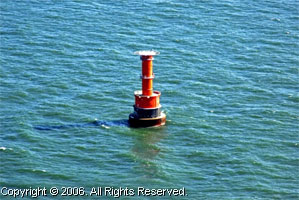
| SW 68 |
Saltviksudde (Gulf of Bothnia)
latitude 61° 40' 47.7" N longitude 17° 14' 48.8" E
Located at the entrance to Hudiksvallfjärd, Gulf of Bothnia (C 6071) ARLHS # SWE-439
Photo courtesy Esbjörn Hillberg (Swedish Lighthouse Society) [fyr] |
|
| SW 69 |
| Vitgrund (Gulf of Bothnia)
A square wooden skeletal tower located on a small island about 2.5 miles east of Skärså. (C 6083) ARLHS # SWE-440
Photo courtesy Esbjörn Hillberg (Swedish Lighthouse Society) [fyr] |
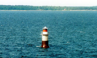
| SW 70 |
Prästgrundet (Gulf of Bothnia)
On a small island about 8 miles ENE of Söderhamn. (C 6086) ARLHS # SWE-438
Photo courtesy Esbjörn Hillberg (Swedish Lighthouse Society) [fyr] |
|
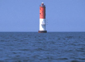
| SW 71 |
| Norrutharet (Gulf of Bothnia)
Located on a small island about 7 miles east of Söderhamn. (C 6088) ARLHS # SWE-437
Photo courtesy Esbjörn Hillberg (Swedish Lighthouse Society) [fyr] |
| SW 72 |
Hællegrund
Located on a shoal about 9 miles east of Söderhamn. The site is closed to the public. ARLHS # SWE-172
Photo courtesy Esbjörn Hillberg (Swedish Lighthouse Society) [fyr] |
|
| SW 73 |
| Storjungfrun
latitude 61° 10' 3.6" N longitude 17° 20' 3.7" E
Located off the eastern tip of Storjungrun island. (C 6122) ARLHS # SWE-064
Photo courtesy Esbjörn Hillberg (Swedish Lighthouse Society) [fyr] |
| SW 75 |
Gåshællen |
ARLHS # SWE-147 |
| SW 76 |
Finngrundet |
About 40 miles ENE of Gåvle, Gulf of Bothnia.The lighthouse replaced the lightship of the same name which is now in the Vasa Museum in Stockholm. photo (C 6250) ARLHS # SWE-012 |
| SW 77 |
Västra Banken |
Located on a shoal in the Gulf of Bothnia about 20 km north northeast of Fagerviken. photo (C 6252) ARLHS # SWE-075 |
| SW 78 |
Trødjehællan
latitude 60° 48' 23.1" N longitude 17° 21' 26.2" E |
Located on a skerry off the eastern tip of the island of Eskön, roughly 15 km northeast of Gävle. ARLHS # SWE-396 |
| SW 79 |
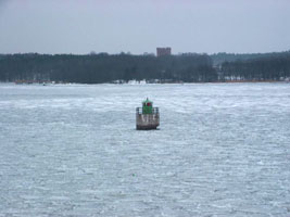
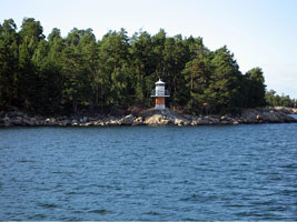
Bönan I
latitude 60° 44' 20.2" N longitude 17° 19' 8.7" E
Located on the north side of the entrance to the Gälve Harbor. ARLHS # SWE-004
Photo courtesy marinas.com [marinas.com] |
|
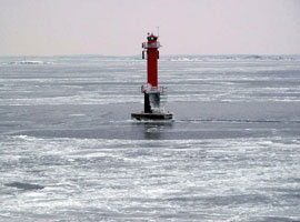
| SW 80 |
| Bønan II
latitude 60° 44' 20.6" N longitude 17° 19' 10.8" E
The small light to the right of the old light (above) (C 6184) ARLHS # SWE-100
Photo courtesy Alex Trabas [ListOfLights] |
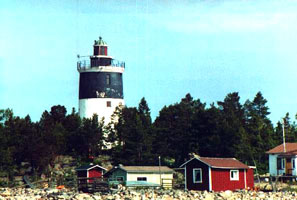
| SW 81 |
Eggegrund
latitude 60° 43' 43" N longitude 17° 33' 29.2" E
On a small island in Gävlebukten (Gävle Bay). (C 6172) ARLHS # SWE-007
Photo courtesy Esbjörn Hillberg (Swedish Lighthouse Society) [fyr] |
|
|
|
| SW 82 |
| Gävlehästen
Located in Arholma. (C 6364)
Photo courtesy Tommy Asplund [Flickr] |
| SW 83 |
Limø I
A red octagonal wooden tower located on the island of Limö at the approach to harbor of Gävle. (C 6176) ARLHS # SWE-262
Photo courtesy Esbjörn Hillberg (Swedish Lighthouse Society) [fyr] |
|
| SW 84 |
| Limø II
A white square steel skeletal tower near the old light (above). (C 6176.1) ARLHS # SWE-263
Photo courtesy Esbjörn Hillberg (Swedish Lighthouse Society) [fyr] |
Uppsala Län
| SW 85 |
Björn
latitude 60° 38' 19.8" N longitude 17° 59' 9.5" E
An 82' concrete tower located about 1.5 miles offshore in southern Bothnia. The grounds are open to the public. ARLHS # SWE-093
Photo courtesy marinas.com [marinas.com] |
|
| SW 86 |
| Örskär
latitude 60° 31' 35" N longitude 18° 22' 23.9" E
Sweden's oldest operating lighthouse is located on an island off northern tip of Grasö. (C 6236) ARLHS # SWE-052
Photo courtesy Esbjörn Hillberg (Swedish Lighthouse Society) [fyr] |
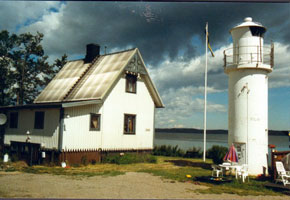
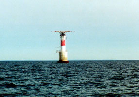
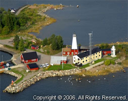
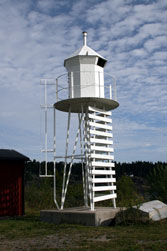
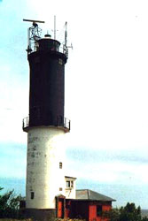
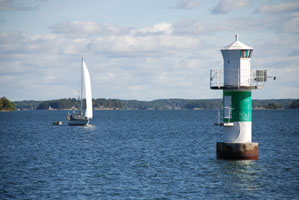
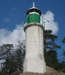
| SW 88 |
Grundkallen
A round cylindrical tower with integral dwelling and helipad on top. It is located offshore in Ålands Sea, about 13 miles NE of Öregrund. (C 6285) ARLHS # SWE-024
Photo courtesy marinas.com [marinas.com] |
|
| SW 89 |
| Engelska Grundet
Located about a mile offshore from west coast of Grasö. (C 6243) ARLHS # SWE-124
Photo courtesy Bengt Agild [webshots] |
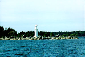
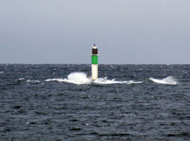
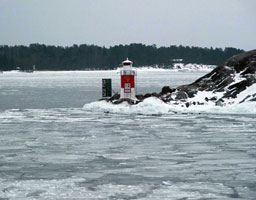
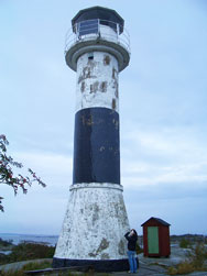
| SW 90 |
Djursten
latitude 60° 22' 8.2" N longitude 18° 24' 4.5" E
The light station also includes a popular café, with music on many evenings. Located on the west side of the island of Grasö, about 3 km northwest of Öregrund. Accessible by ferry. (C 6244) ARLHS # SWE-116
Photo courtesy marinas.com [marinas.com] |
|
| SW 90B |
| Bellonagrundet
Located 500 m west of the Djursten lighthouse. (C 6245)
Photo courtesy Esbjörn Hillberg (Swedish Lighthouse Society) [fyr] |
| SW 91 |
Ørngrund |
ARLHS # SWE-303 |
| SW 92 |
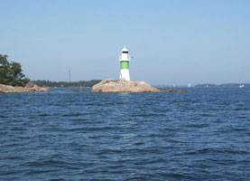
Understen I
latitude 60° 16' 29.6" N longitude 18° 55' 7.9" E
This light station stands in the northern entrance to the strait connecting the Gulf of Bothnia to the Baltic Sea, west of the Åland Islands; this broad sound is called the Ålands Sea in Sweden. Located on a small island about 9 km northeast of Singö and about 20 km northwest of the westernmost of the Ålands. (C 6288) ARLHS # SWE-402
Photo courtesy Esbjörn Hillberg (Swedish Lighthouse Society) [fyr] |
|
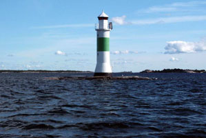
| SW 93 |
| Untersten II
latitude 60° 16' 28.6" N longitude 18° 55' 10.9" E
I'm told this is near the light above, Google shows it to be south and east. ARLHS # SWE-071
Photo courtesy Esbjörn Hillberg (Swedish Lighthouse Society) [fyr] |
Stockholms Län
| SW 94 |
Långøskar |
ARLHS # SWE-233 |
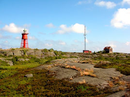
| SW 95 |
Svartklubben (C 6290) ARLHS # SWE-386
Photo courtesy Esbjörn Hillberg (Swedish Lighthouse Society) [fyr] |
|
| SW 96 |
| Simpnäsklubb
The modern lighthouse stands beside the stone foundation of the original. Located on a skerry off the northeast side of the island of Björkö. (C 6362) ARLHS # SWE-340
Photo courtesy Bengt Agild [webshots] |
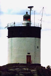
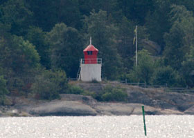
| SW 97 |
Näskubben
Located on a promontory at the eastern tip of Björkö, marking the entrance to the strait separating Björkö from Arholma (C 6366) ARLHS # SWE-285
Photo courtesy Esbjörn Hillberg (Swedish Lighthouse Society) [fyr] |
|
|
|
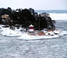
| SW 97D |
| Dejeudden (C 6372)
Photo courtesy Tommy Asplund [Flickr] |
| SW 98 |
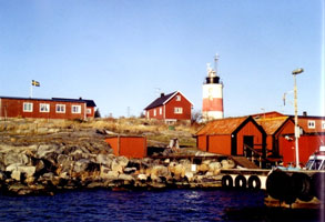
Arholma
latitude 59° 50' 41.6" N longitude 19° 6' 10.7" E
Located somewhere SW of the town named after the island. photo (C 6370) ARLHS # SWE-085
Photo courtesy Alex Trabas [ListOfLights] |
|
| SW 99 |
| Tjarven
Located on a small island about 3 miles northwest of the Söderarm lighthouse. (C 6386) ARLHS # SWE-393
Photo courtesy (2007)Tommy Asplund [Flickr] |
| SW 100 |
Tyvø |
Located on the western point of the island of Tyvö, near the village of the same name, about 3 km northeast of Rävsnäs on Björkö. (C 6374) ARLHS # SWE-400 |
| SW 101 |
Tjockö
One of the best places for bathing is Tjockö´s northwestern shore, along the road to the lighthouse. (C 6382) ARLHS # SWE-394
Photo courtesy Alex Trabas [ListOfLights] |
|
| SW 102 |
| Remmargrund
Located on a shoal about 3 km southeast of the island of Vattungarna. Best viewed from ferries to Finland. (C 6386.9) ARLHS # SWE-320
Photo courtesy Tommy Asplund [Flickr] |
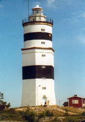
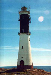
| SW 103 |
Söderarm
latitude 59° 45' 10.3" N longitude 19° 24' 21.7" E
On Torskär Island in the Roslagen archipelago. (C 6384.51) ARLHS # SWE-059
Photo courtesy Esbjörn Hillberg (Swedish Lighthouse Society) [fyr] |
|
| SW 104 |
| Lerskærgrund
Located on a shoal about 3 km east of the island of Fejan. (C 6390) ARLHS # SWE-235
Photo courtesy Ronald Woehrn [ListOfLights] |
| SW 105 |
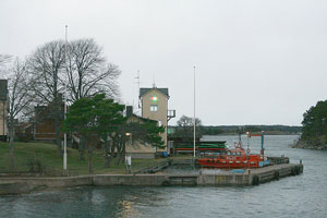
Kapellskær
About 38 miles NE of Stockholm, Kapellskär is the terminal for ferries sailing for the Åland Islands and for Turku, Finland. The light is located on the northern tip of an island about ½ mile east of the Kapellskär waterfront. (C 6412) ARLHS # SWE-210
Photo courtesy Bengt Agild [webshots] |
|
| SW 106 |
Svenska Bjørn |
Located on a shoal in the middle of the Baltic Sea about 17 miles east of Svenska Högarna and 33 miles east of Möja. (C 6459) ARLHS # SWE-065 |
| SW 107 |
Svenska Högarna
latitude 59° 26' 37.6" N longitude 19° 30' 6.3" E
This historic lighthouse is located on an island far out in the Baltic, about 15 miles east of Möja. (C 6460) ARLHS # SWE-066
Photo courtesy Nelson Harris [Flickr] |
|
| SW 108 |
| Korsö
Located on the south side of the island of Korsö, about 2.5 km east of Sandhamn. ARLHS # SWE-216
Photo courtesy niad [wikipedia] |
| SW 109 |
Stenkobbsgrund
Located on a skerry about 500 m north of Lökaön island and 1.5 km east of the eastern tip of Möja island. (C 6404) ARLHS # SWE-368
Photo courtesy Bengt Agild [webshots] |
|
| SW 110 |
| Pålkobb
courtesy Bengt Agild (C 6406) ARLHS # SWE-311
Photo courtesy community.webshots.com/user/agild [webshots] |
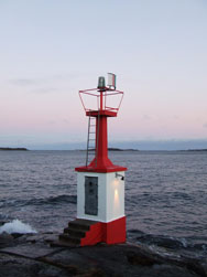
| SW 111 |
Sandgrundet
latitude 59° 23' 45.3" N longitude 18° 21' 42.4" E
Located about 700 m southeast of the Vaxholm waterfront. (C 6528) ARLHS # SWE-333
Photo courtesy Alex Trabas [ListOfLights] |
|
| SW 111B |
| Bogesund
latitude 59° 22' 51" N longitude 18° 18' 14.3" E
Located in the channel south of Karlsudd. (C 6536)
Photo courtesy Bengt Agild [webshots] |
| SW 111G |
Granholmen
latitude 59° 22' 39.8" N longitude 18° 17' 39.4" E
This lantern displays directional lights guiding outbound (eastbound) vessels. Located at the west end of an island southwest of Karlsrudd. (C 6538)
Photo courtesy Bengt Agild [webshots] |
|
| SW 112 |
| Ålvviksgrundet
latitude 59° 21' 50.3" N longitude 18° 15' 32.2" E
Located off Elfviksudde, the southeastern point of Lidingö. ARLHS # SWE-081
Photo courtesy Per Elkisson [panoramio] |
| SW 113 |
Kalvøn
Located on the south side of the channel about ½ mi east of Boda. ARLHS # SWE-209
Photo courtesy Jim Grant [Flickr] |
|
| SW 114 |
Kurøn
latitude 59° 20' 3.4" N longitude 17° 29' 20.1" E |
ARLHS # SWE-226 |
| SW 115 |
Yxhammarsklubben
Located on a skerry off the northwestern end of Skarprunmarö, about 7 km west of Sandhamn. ARLHS # SWE-061
Photo courtesy Bengt Agild [webshots] |
|
| SW 116 |
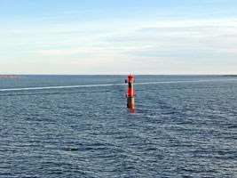
Skøtkobben |
The front light of a "leading range" (C 6484) ARLHS # SWE-349 |
| SW 117 |
Sandhamn
Located on the waterfront of Sandhamn, a popular boating town on the north side of the island of Sandö. ARLHS # SWE-056
Photo courtesy Henrik Larsson [Flickr] |
|
| SW 118 |
Sandhamns Stångskær |
Located on a skerry 1.6 km east of the eastern tip of Korsö. (C 6468) ARLHS # SWE-335 |
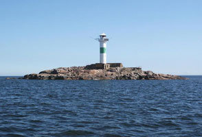
| SW 119 |
Grönskär
latitude 59° 16' 40.6" N longitude 19° 1' 27.9" E
This historic lighthouse was deactivated in 1961, when the Revengegrundet light was built farther out in the Baltic. Located on a small island about 4.5 miles east of Sandhamn. SW 122 (C 6468.5) ARLHS # SWE-157
Photo courtesy Esbjörn Hillberg (Swedish Lighthouse Society) [fyr] |
|
| SW 121 |
Svængen (Sandhamnssundet) |
Located on a shoal about 3 miles ESE of Sandhamn. photo ARLHS # SWE-385 |
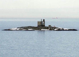
| SW 122 |
Revengegrundet
Located on a shoal about 5 km south southeast of Sandhamn. (C 6470) ARLHS # SWE-321
Photo courtesy Bengt Agild [webshots] |
|
| SW 123 |
| Almagrundet
A black concrete tower with a heli pad on the top. It is located on a shoal about 10 miles SE of Sandhamn in the Baltic Sea. (C 6465) ARLHS # SWE-002
Photo courtesy marinas.com [marinas.com] |
| SW 124 |
Myssingeholm |
ARLHS # SWE-283 |
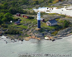
| SW 125 |
Huvudskär
Huvudskär is the largest of a group of islands that together form the southeasternmost extension of the Stockholm Archipelago. The island is accessible by passenger ferry from Stockholm. Located at the highest point of the island. (C 6576) ARLHS # SWE-202
Photo courtesy Ullis Anderson [Flickr] |
|
| SW 127 |
| Brunsviksholmen
Located on the north side of the entrance to Nynäshamn harbor. (C 6614) ARLHS # SWE-109
Photo courtesy Seth & Jaclyn Chisamore [Flickr] |
|
|

 Northeastern Sweden
