|
This page currently shows the documentation of the Lighthouses of Ecuador. The pictures below are linked to the relevant photo on the web (thus making available to you a higher resolution picture.) Each lighthouse name is linked to (in our editorial opinion) the best reference site for that light. I would like to include directions on how to get to these lights. If you know such data, could you eMail me and I'll post it here (with your choice of attribution.) mailMe |
|
| EC 1 |
Bajo Salinas |
ARLHS # ECU-015 |
| EC 2 |
Punta Jambeli (Guayaquil)
latitude 3° 12' 38.5" S longitude 80° 1' 38.7" W |
The northernmost point of the Isla Jambelí, an island off the entrance to Puerto Bolívar. ARLHS # ECU-003 |
| EC 3 |
Isla Santa Clara (Isla el Muerto) |
ARLHS # ECU-001 |
| EC 4 |
Punta Arenas Guayaquil
latitude 3° 1' 17.8" S longitude 80° 7' 24.9" W |
Located off the southeastern tip of the large Isla de Puna, marking the north side of the southern entrance to the Bahía de Guayaquil. ARLHS # ECU-002 |
| EC 5 |
Punta Espanola (Isla de Puna) |
ARLHS # ECU-034 |
| EC 6 |
Punta Mandinga (Guayaquil) |
ARLHS # ECU-004 |
| EC 7 |
Isla Verde |
Located on a promontory about 2.5 km northeast of Ríoverde. ARLHS # ECU-020 |
| EC 8 |
Chapoya |
ARLHS # ECU-005 |
| EC 9 |
Punta del Piedra |
ARLHS # ECU-033 |
| EC 10 |
El Real
latitude 2° 23' 36.4" S longitude 80° 43' 34.6" W |
Located on a headland near El Real, about 50 km southeast of Punta Santa Elena. ARLHS # ECU-038 |
| EC 11 |
Rompeolas |
ARLHS # ECU-039 |
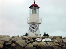
| EC 12 |
Salinas Yacht Club
Purchased from the Navy by the Guayaquil Yacht Club in 1956, the lantern and lens are on loan to the Salinas Yacht Club. Located on the yacht club's breakwater in Salinas.
Photo courtesy Tonie Chio [webshots] |
|
| EC 13 |
Capay on Hill |
ARLHS # ECU-017 |
|
|
| EC 14 |
Chocolatera (La Puntilla)
latitude 2° 11' 22.8" S longitude 81° 38.4" W |
Near Salinas, Tip of Punta Santa Elena. photo ARLHS # ECU-022 |
| EC 15 |
Santa Elana |
Punta Santa Elena, the westernmost point of mainland Ecuador, is a very sharp promontory. Located above the cape on the hill known as La Puntilla, about 3 km west of the yacht club light. photo ARLHS # ECU-006 |
| EC 16 |
Islote el Pelado |
ARLHS # ECU-021 |
| EC 17 |
Isla Salango |
ARLHS # ECU-019 |
| EC 18 |
Palo Seco |
ARLHS # ECU-024 |
| EC 19 |
Isla La Plata NW. End (Summit) |
ARLHS # ECU-018 |
| EC 20 |
Puerto Limoges |
ARLHS # ECU-031 |
| EC 21 |
Punta la Barca (Isla Limoges) |
ARLHS # ECU-035 |
| EC 22 |
San Pedro |
ARLHS # ECU-040 |
| EC 23 |
Cabo San Lorenzo |
Located atop a steep bluff on the Cabo de San Lorenzo, a very prominent cape about 30 km southwest of Manta. ARLHS # ECU-007 |
| EC 24 |
Puerto de Esmeraldas N. Breakwater Head F1 |
ARLHS # ECU-027 |
|
|
| EC 25 |
Puerto de Esmeraldas S. Side E. End F2 |
ARLHS # ECU-030 |
| EC 26 |
Puerto de Esmeraldas E. Side N. End F3 |
ARLHS # ECU-026 |
| EC 27 |
Puerto de Esmeraldas Range Front F1 |
ARLHS # ECU-028 |
| EC 28 |
Puerto de Esmeraldas Range Rear E2 |
Located on the east side of the bay about 12 km opposite Carrizal. ARLHS # ECU-029 |
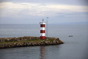
| EC 30 |
Puerto da Manta Breakwater
latitude 55' 46.9" S longitude 80° 43' 10.2" W
Located at the end of the east breakwater at Manta. ARLHS # ECU-008
Photo courtesy Dave Nelson [Flickr] |
|
| EC 31 |
Punta Jaramijo
latitude 55' 43.1" S longitude 80° 39' 24.1" W |
Located on the east side of the entrance to the harbor of Manta. ARLHS # ECU-009 |
| EC 32 |
Punta Sua |
Located on a cape about 30 km southwest of Esmeraldas. ARLHS # ECU-037 |
| EC 33 |
Cabo de San Francisco |
ARLHS # ECU-016 |
| EC 34 |
Punta Bellaca |
ARLHS # ECU-032 |
| EC 35 |
Punta Pedernales |
ARLHS # ECU-036 |
| EC 36 |
Cabo Pasado |
ARLHS # ECU-010 |
| EC 37 |
Punta Ballena |
ARLHS # ECU-011 |
| EC 38 |
Punta Galera
latitude 49' 30" N longitude 80° 3' 4" W |
About 60 miles southwest of Esmeraldas ARLHS # ECU-012 |
| EC 39 |
Esmeraldas
latitude 59' 41.9" N longitude 79° 38' 47.2" W |
ARLHS # ECU-041 |
| EC 41 |
Mogote Sur |
ARLHS # ECU-023 |
| EC 42 |
Payana Isla San Gregorio |
Located at the westernmost point of the Isla San Gregorio, just north of the Peruvian border. ARLHS # ECU-025 |
Archipiélago de Colón
(Galápagos Islands)
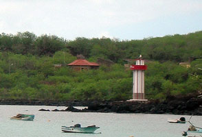
| EC 50 |
Playaman (San Cristóbal)
latitude 53' 48.4" S longitude 89° 36' 35.1" W
San Cristóbal is the easternmost of the islands. Located on a rocky point north of Puerto Barquerizo Moreno near the southwestern tip of the island.
Photo courtesy Patricia Young,Toronto, Canada [Flickr] |
|
| EC 51 |
Jamebelí |
Northeastern side of Isla Jambelí, west side of entrance to Río Santa Rosa. |
| EC 52 |
Puerto Ayora (Guauaquil) |
South coast of Isla de Santa Cruz, Galápagos Islands. photo |
| EC 53 |
Puerto Bolívar |
Southern entrance to Bahía de Guayaquil. |
| EC 55 |
Patricio Hill (San Cristóbal) |
Located on a hill above the harbor of Puerto Barquerizo Moreno. |
|
|

 Colombia