|
This page currently shows the documentation of the Lighthouses of Colombia. The pictures below are linked to the relevant photo on the web (thus making available to you a higher resolution picture.) I am very grateful to Russ Rowlett at the University of North Carolina for his excellent Lighthouse Directory for the outline. Each lighthouse is linked to (in our editorial opinion) the best reference site for that light. LHdirectory I would like to include directions on how to get to these lights. If you know such data, could you eMail me and I'll post it here (with your choice of attribution.) mailMe |
|
| CO 2 |
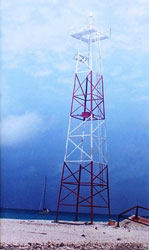
Bajo Nuevo
Bajo Nuevo is a small reef far out in the Caribbean southwest of Jamaica. It is or has been claimed by the U.S., Honduras, Jamaica, and Colombia.
Photo courtesy Ana María Jaramillo [panoramio] |
|
| CO 3 |
Banco Serrana |
The Serrana Bank is about 225 mi east of Nicaragua. Located on Southwest Cay. |
| CO 4 |
Banco Roncador |
Roncador Bank is about 135 mi northeast of San Andres. Located at the northernmost point of the reef. |
| CO 5 |
Cayo Palma
latitude 13° 24' 1.8" N longitude 81° 22' 14.5" W
Located on a reef off the northernmost point of Isla Providencia. Accessible only by boat. ARLHS # COL-022
Photo courtesy Maqroll [Flickr] |
|
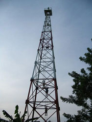
| CO 6 |
Castillettes
latitude 11° 51' 6.4" N longitude 71° 19' 28.8" W |
A 1-story border control station stands a short distance north of the lighthouse. Located about 600 m north of the Venezuelan border on the southeast side of the Guajira Peninsula. photo ARLHS # COL-019 |
| CO 7 |
Punta Espada
The lighthouse marks the easternmost point of the Guajira Peninsula. Located on a bluff above the cape. ARLHS # COL-040
Photo courtesy Juank [Panoramio] |
|
| CO 8 |
Chichibacoa |
ARLHS # COL-024 |
| CO 9 |
Puerto Estrella |
ARLHS # COL-033 |
Caribbean Coast
| CO 10 |
Punta Gallinas
latitude 12° 27' 28.3" N longitude 71° 40' 4.5" W |
This modest tower is the northernmost lighthouse of South America, standing at latitude 12° 27.5' north. Located on the cape, about 18 km north of Inosu. Only access is by 4WD. photo ARLHS # COL-042 |
| CO 12 |
Punta Manaure |
Located on a promontory on the east side of Manaure, a salt-mining town on the west side of the Guajira Peninsula. ARLHS # COL-044 |
| CO 13 |
Riohacha
latitude 11° 32' 33.3" N longitude 72° 55' 48.3" W |
Located in Riohacha, a port about 150 km east of Santa Marta. The 1857 lantern was mounted on the tower of the cathedral of Nuestra Señora de los Remedios. photo ARLHS # COL-050 |
| CO 14 |
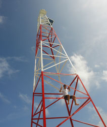
Cabo de la Vela
latitude 12° 12' 35.1" N longitude 72° 10' 45.2" W
Cabo de la Vela is a 'resort area' (rustic, not 5*), and tourists often hike to the lighthouse to enjoy the spectacular view. This area is very far removed (takes 4 hours by rough road and in absence of road across the desert from Riohacha). This photo highlights the sail shaped rock, which is where the name of the cape ('Vela') came from. hike ARLHS # COL-016
Photo courtesy Emilie Baird de Vargas [Flickr] |
|
|
|
| CO 15 |
| Isla Fuerte
Isla Fuerte is an island about 6 mi off the coast at the southern entrance to the Golfo de Morrosquillo. Resorts on the island are popular with scuba divers. Located on the east side of the island. ARLHS # COL-025
Photo courtesy fabergallego2 [webshots] |
| CO 17 |
Tumaco (Morro Island) |
The lighthouse is located on a Colombian naval base. Located on an island sheltering the harbor of Tumaco on Colombia's southernmost coast. ARLHS # COL-054 |
| CO 18 |
Morro Grande (Bahia Santa Marta)
latitude 11° 14' 60" N longitude 74° 13' 49.4" W |
Located on a steep-sided island in the entrance to the harbor of Santa Marta ARLHS # COL-028 |
| CO 19 |
Isla de los Gomez |
ARLHS # COL-071 |
| CO 21 |
Galerazamba (Punta Galera)
latitude 10° 47' 6" N longitude 75° 15' 59" W |
Located on a headland about halfway between Cartagena and Barranquilla. photo ARLHS # COL-026 |
| CO 22 |
Punta Canoas
latitude 10° 34' 33.9" N longitude 75° 29' 50" W |
Located on a steep bluff overlooking the Caribbean about 25 km north of Cartagena. ARLHS # COL-036 |
| CO 23 |
Cartagena la Merced |
ARLHS # COL-070 |
| CO 24 |
Baluarte de Santo Domingo |
ARLHS # COL-068 |
| CO 25 |
Banco Salmedina |
This light marks the beginning of the approach to Cartagena. Located on a low bank about 8 km off the coast and 16 km west of Cartagena. ARLHS # COL-012 |
| CO 26 |
Castillo Grande (Cartagena)
latitude 10° 23' 28.4" N longitude 75° 32' 41.7" W
Castillo Grande is an upscale neighborhood accessible to tourists. Located at the end of a peninsula sheltering the inner harbor of Cartagena. ARLHS # COL-037
Photo courtesy Peter Mosselberger [ListOfLights] |
|
|
|
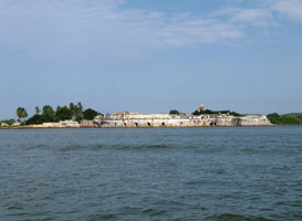
| CO 27 |
| Isla Tierra Bomba
Tierra Bomba is a large island sheltering the harbor of Cartagena. Located on one of the highest points of the island. Site and tower closed. (J 6166) ARLHS # COL-052
Photo courtesy Capt. Peter Mosselberger [ListOfLights] |
| CO 28 |
Bocachica (Fuerte de San Fernando)
This picture is of the fort. It contains no description where the light may be. ARLHS # COL-069
Photo courtesy Peter [Flickr] |
|
| CO 29 |
| Tesoro Island
Located on a small island about 25 km southwest of Cartagena. (J 6160) ARLHS # COL-009
Photo courtesy Captain Peter Mosselberger [ListOfLights] |
| CO 30 |
Mucura Island |
Isla Múcura is a small island resort in the Islas de San Bernardo, about 80 km southwest of Cartagena. ARLHS # COL-029 |
| CO 31 |
Ceycen (San Bernardo Island) |
ARLHS # COL-023 |
| CO 32 |
Roca Morrosquillo |
ARLHS # COL-067 |
| CO 33 |
Punta de Piedra
latitude 9° 25' 11.5" N longitude 75° 39' 4.6" W |
Located in the Punta de Piedra resort area, about 130 km south of Cartagena. ARLHS # COL-061 |
| CO 34 |
Tortuguilla Island |
ARLHS # COL-053 |
| CO 35 |
Cabo Tiburon |
This lighthouse marks the Panamanian border and the west side of the entrance of the Gulf of Urabá. ARLHS # COL-017 |
| CO 36 |
Punta Caribana |
Located on a prominent cape at the east side of the entrance of the Gulf of Urabá. ARLHS # COL-018 |
| CO 37 |
Punta Caiman |
Located on a prominent cape on the east side of the Gulf of Urabá, about 25 km north of Turbo. ARLHS # COL-035 |
| CO 38 |
Punta Yarumal |
Located on a long spit leading to the town of Turbo on the east side of the Gulf of Urabá. ARLHS # COL-047 |
Pacific Coast
| CO 39 |
Punta Ardita |
In northwestern Colombia the Baudó mountains rise very steeply from the Pacific coast, and this lighthouse stands on the northernmost major promontory. Located about 8 km southeast of the Panamanian border. ARLHS # COL-060 |
| CO 40 |
Cabo Marzo |
ARLHS # COL-057 |
| CO 41 |
Punta Solano |
ARLHS # COL-064 |
| CO 42 |
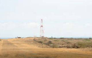
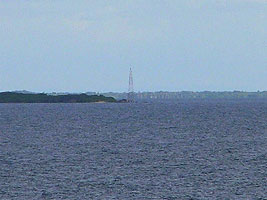
Nuqui |
A photo is available. photo ARLHS # COL-059 |
| CO 43 |
Punta Charambira |
Located on a low cape about 130 km northwest of Buenaventura. ARLHS # COL-062 |
| CO 44 |
Isla Palmas |
Located on an island at the northern entrance to the Bahía de Buenaventura. ARLHS # COL-058 |
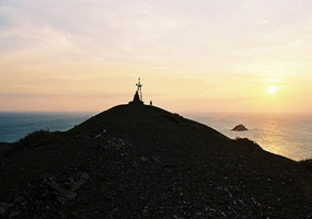
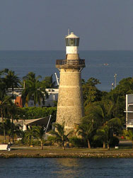
| CO 45 |
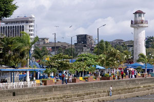
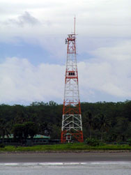
Parque de Buenaventura
This lighthouse is located in a public park on the waterfront in Buenaventura, Colombia's principal port on the Pacific. ARLHS # COL-056
Photo courtesy Shaun McRae [wikipedia] |
|
| CO 46 |
| Punta Soldado
Located on the south side of the entrance to the harbor of Buenaventura. (G 3132) ARLHS # COL-065
Photo courtesy Capt. Peter Mosselberger [ListOfLights] |
| CO 47 |
Rio Naya |
ARLHS # COL-066 |
| CO 48 |
Punta Coll |
Gorgona is an island about 50 km off the Colombian coast halfway between Buenaventura and Tumaco. Formerly the site of a political prison, the island is now a national park with facilities for ecotourism. Located at the northern tip of the island. ARLHS # COL-063 |
|
|
 Lesser Antilles


