|
This page shows the documentation of the Lighthouses between Mexico and Panama. In addition, the pictures below are linked to the relevant photo on the web (thus making available to you a higher resolution picture.) I am very grateful to Russ Rowlett at the University of North Carolina for his excellent Lighthouse Directory for the outline. Each lighthouse is linked to (in our editorial opinion) the best reference site for that light. LHdirectory I'd like to provide directions to get to these lights. If you know how, could you send me that? mailme |
|
| BZ 1 |
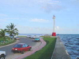
Fort George (Baron Bliss)
Built as a memorial to an English baron who was a major benefactor of Belize; the baron's tomb is at the base of the tower. Located on a point of land at the harbor entrance in Belize City. This light is within walking distance from the cruise port. ARLHS # BLZ-014
Photo courtesy Donna McGrew [Flickr] |
|
| BZ 2 |
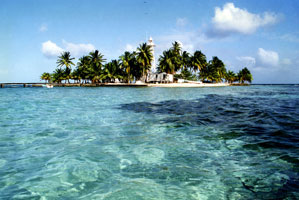
| English Caye (Eastern Channel Range Rear)
The station is now the Belize pilot station, with several buildings and a pier for the pilot boats. Located on a small island about 15 km southeast of Belize Harbour. Accessible only by boat, but visible from all ships entering the harbor. ARLHS # BLZ-012
Photo courtesy Paul Huisking, Asheville NC [Flickr] |
| BZ 3 |
Sandbore Caye |
Located about 50 km east of Belize City on a small cay at the northern end of Lighthouse Reef, a coral atoll famous as a diving site. |
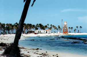
| BZ 4 |
Half Moon Caye (1931)
Located on Half Moon Caye at the southeast corner of Lighthouse Reef, a coral atoll famous as a diving site. Accessible only by boat. ARLHS # BLZ-017
Photo courtesy dasso [Flickr] |
|
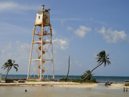
| BZ 5M |
Mauger Caye
latitude 17° 36' 25.5" N longitude 87° 46' 21" W
Mauger Caye is the northernmost islet of the Turneffe Cays, an extensive reef system 75 km long and about 30 km east of Belize City.
Photo courtesy Serge Melki [Flickr] |
|
| BZ 6 |
Bugle Caye
latitude 16° 29' 16.4" N longitude 88° 19' 25.3" W |
Located on a small cay off the coast about 130 km south of Belize City. photo ARLHS # BLZ-002 |
| BZ 7 |
East Snake Caye |
South coast of Belize. It seems there are 2 lights here (a new one has be built near the old one.) ARLHS # BLZ-005 |
| BZ 9 |
Hunting Caye Zapodilla Cay |
Hunting Caye is at the southern end of the Sapodilla Cayes, about 65 km east of Punta Gorda; this is the southeastern-most point of Belizean territory. photo ARLHS # BLZ-015 |
|
|
| HO 1 |
Puerto Cortes (Punta Caballos) |
Located at the western end of the peninsula sheltering the harbor of Puerto Cortes, about 8 km northwest of the city. ARLHS # HON-008 |
| HO 2 |
Isla de Roatan
Located at the western end of the island, largest of the Bay Islands, about 150 km north of the mainland. Accessible by road. ARLHS # HON-008
Photo courtesy KM&G Morris [Flickr] |
|
| HO 3 |
Cochino Grande |
Sibling of Isla de Roatan (above). The photographer reports that the lighthouse 'doesn't work.' The lighthouse is said to have been built in Germany. Located on Cochino Grande in the Cayos Cochinos off La Ceiba on the north central coast of the country. coyoscochinos ARLHS # HON-007 |
| HO 4 |
Cabo Camaron |
The cape is about 65 km east of Limón. ARLHS # HON-001 |
| HO 5 |
Punta Patuca |
The Punta Caballos, Isla de Roatan, and Cochino Grande lights and this light probably share a common design. Located on a cape about 35 km east southeast of Cabo Camaron. ARLHS # HON-009 |
| HO 6 |
Cabo Falso |
Cabo Falso is so called because it is easily mistaken for Cabo Gracias a Dios, the prominent cape at the Nicaraguan border. Located on the cape, about 30 km northwest of Cabo Gracias a Dios. Don't confuse with the light with the identical name on the West coast of Mexic MX 85 |
| ES 1 |
Punta Remedios
latitude 13° 31' 35.2" N longitude 89° 48' 20.3" W |
Located on the cape at Los Cóbanos, southeast of Acajutla. Site open, but some local knowledge is probably needed to find it; tower closed ARLHS # ELS-001 |
|
|
| ES 2 |
Punta Chiquirin |
This light is on the western side of the Golfo de Fonseca, guiding vessels to El Salvador's port of La Unión. Located on the cape, at the southeastern end of El Salvador, about 8 km southeast of La Unión. ARLHS # ELS-002 |
| NI 1 |
Isla el Cardón (Morro Cardón, Corinto) |
Located at the north point of Isla El Cardón, marking the entrance to the harbor of Corinto. |
| NI 2 |
San Juan del Sur
Located on a bluff above the harbor entrance. The walk up to the lighthouse is really nice, it starts off by the port and goes up alongside some shacks built on the lower hills.
Photo courtesy Tony Shaw [Flickr] |
|
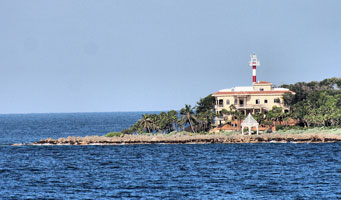
| CR 1 |
| Los Sueños
Located at a modern resort on the east side of the entrance to the Golfo de Nicoya, about 65 km south of Puntarenas.
Photo courtesy gtobabe2u [webshots] |
| CR 2 |
Isla del Caño |
The Isla del Caño is a 740 acre island located about 20 km west of the Osa Peninsula in southern Costa Rica. It is now a national park and is a popular destination for day trips. The lighthouse is located at the southwestern tip of the island and is accessible by a hiking trail. ARLHS # COS-003 |
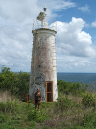
| CR 4 |
Herradura Island |
An old lighthouse adorns the crest of the tropical forest covering the island. Whether you can get to it is not stated. ARLHS # COS-004 |
| CR 5 |
Negritos Island |
The two Islas Negritos are part of a dangerous reef system extending from the west side of the Gulf of Nicoya east of Paquera. Located at the eastern end of the island. ARLHS # COS-005 |
| CR 6 |
Puerto Limon |
ARLHS # COS-006 |
| CR 7 |
Punta San Pedro |
ARLHS # COS-002 |
|
|
 Mexico West
