|
This page shows the documentation of the Lighthouses of Sardinia. Some of the photos below are available on webshots, some of the are on Flickr (and are reproduced with permission) and you can almost always click on the light to go to its specific (larger resolution) copy. Each lighthouse is linked to (in our editorial opinion) the best reference site for that light. I would like to include directions on how to get to these lights. If you know such data, could you eMail me and I'll post it here (with your choice of attribution. mailme There has been significant usage of the Lighthouse Directory prepared by Russ Rowlett (UNC). My thanks to him for providing this basis for understanding. lhDirectory Starting geographic coordinates were gathered from the Lighthouse Depot Database. |
|
Strait of Bonifacio
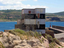
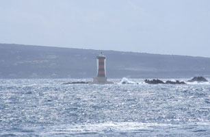
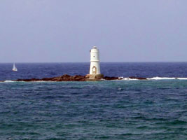
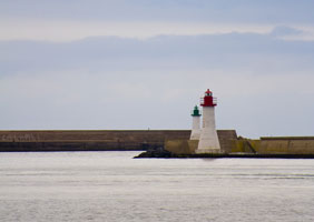
| IT 61 |
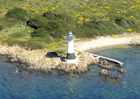
Corcelli (Barrettinelli di Sopra)
latitude 41° 18' 5.8" N longitude 9° 24' 2.8" E
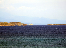
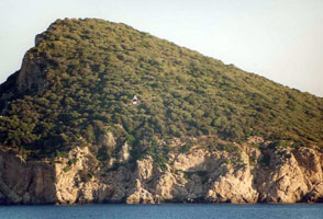
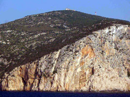
The Strait of Bonifacio, only 11 km wide, separates Corsica from Sardinia. Strewn with rocks and shoals, it is one of the most dangerous passages in the western Mediterranean. Located on a dangerous rock near the southeastern entrance to the strait, about 8 km north of La Maddalena. Accessible only by boat in rough seas. (E 0946) ARLHS # SAR-026
Photo courtesy Arno Siering [ListOfLights] |
|
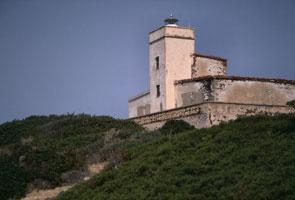
| IT 62 |
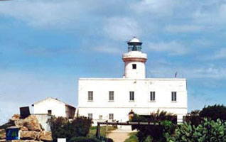
| Santa Maria (Punta Filetto)
latitude 41° 17' 54.7" N longitude 9° 23' 2.2" E
There are several private vacation homes on the Isola di Sant Maria, some of which can be rented in season. The lighthouse has been empty since it was automated in 1972, but the national park has drafted plans to restore it. Located on the north point of the island, facing the strait; the location is only 1.4 km west of the Corcelli light. Accessible only by boat, but landing facilities are available.
Photo courtesy Egido Ferrighi [fari] |
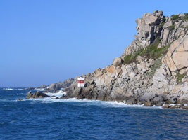
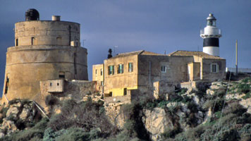
| IT 63 |
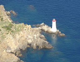
Razzoli (1913?)
latitude 41° 18' 24.5" N longitude 9° 20' 23.5" E
Endangered: abandoned since 1969, it is in very poor condition today, but it looks like they are restoring it. The Isola di Razzoli is the northwestern end of the Arcipelago di la Maddalena; it is the island closest to Corsica. Located at the northwestern tip of the island. Accessible only by boat; ecotours to the island are available. photo
Photo courtesy Roberta Spiga and Océane Legrand [Sardinia] |
|
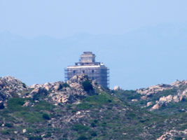
| IT 64 |
| Razzoli (1974)
latitude 41° 18' 25.3" N longitude 9° 20' 23.5" E
Located on the seaward side of the historic lighthouse.
Photo courtesy Radiluca [panoramio] |
| IT 65 |
Longonsardo (Santa Teresa Gallura)
latitude 41° 14' 29" N longitude 9° 11' 50.3" E
Located on the east side of the entrance to the harbor of Santa Teresa Gallura, the town at the northernmost tip of Sardinia. Apparently accessible only by boat; there should be a good view from ferries arriving from Bonifacio, Corsica. ARLHS # SAR-028
Photo courtesy Zsolt Porkolab [panoramio] |
|
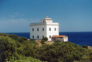
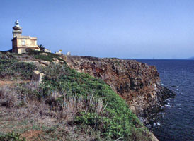
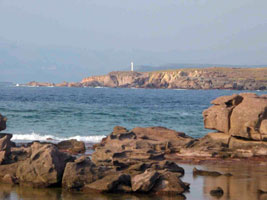
| IT 66 |
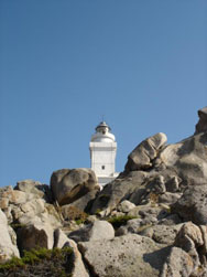
| Capo Testa
latitude 41° 14' 37" N longitude 9° 8' 39.1" E
This handsome lighthouse stands on a steep headland on a promontory connected to the mainland by a narrow isthmus. It marks the northern tip of Sardinia and the western entrance to the Strait of Bonifacio. Located at the end of highway of highway SP90 about 7 km west of Santa Teresa Gallura. ARLHS # SAR-021
Photo courtesy Fabio Sergio [Flickr] |
Northwest Coast
| IT 67 |
Porto Torres (1825)
latitude 40° 50' 22.2" N longitude 8° 24' 5.3" E
Located just behind the waterfront of Porto Torres (Port of the Towers), a port at the northwestern corner of Sardinia. ARLHS # SAR-047
Photo courtesy allabord54 [webshots] |
|
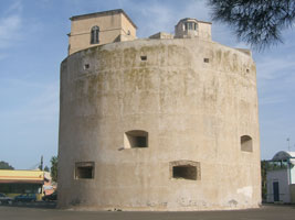
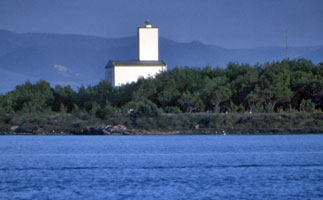
| IT 68 |
| Porto Torres (1966)
latitude 40° 50' 9.8" N longitude 8° 23' 49.7" E
This interesting modern lighthouse was built to give Porto Torres a light with much greater range than the historic tower. Located atop a hill (Monte Angellu) on the west side of the town, overlooking the harbor. (E 1138) ARLHS # SAR-033
Photo courtesy Arno Siering [ListOfLights] |
| IT 68S |
Stintino Secca
latitude 40° 56' 9.6" N longitude 8° 13' 55.6" E
Located on a shoal in the center of the entrance to the harbor at Stintino. (E 1134)
Photo courtesy Arno Siering [ListOfLights] |
|
| IT 68W |
Stintino West Entrance
latitude 40° 56' 11.6" N longitude 8° 13' 48.7" E |
Located on the waterfront in Stintino, this new light is not listed by NGA or the Admiralty. |
| IT 69 |
Asinara (Punta Scorno, Isola dell'Asinara)
latitude 41° 7' 10.3" N longitude 8° 19' 7.8" E
The Isola dell'Asinara is a rugged island off the northwestern tip of Sardinia. Formerly used as a prison, the island is now a national park but is open only with special permission. Located at the northern tip of the island.
Photo courtesy Andrea Utzeri [farisardegna] |
|
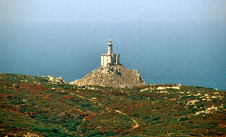
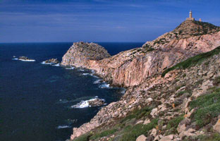
| IT 70 |
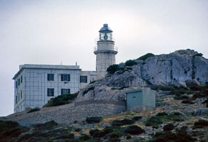
| Capo Caccia
latitude 40° 33' 39.4" N longitude 8° 9' 46.3" E
Located atop a vertical cliff at the extreme southern tip of the peninsula sheltering the harbor of Porto Conte. ARLHS # SAR-009
Photo courtesy Andrea Utzeri [farisardegna] |
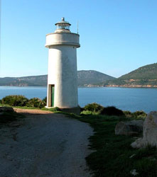
| IT 71 |
Porto Conte
latitude 40° 35' 37.2" N longitude 8° 12' 16.2" E
The original light was listed as an iron tower. Located on a promontory projecting into the bay of Porto Conte just west of the town. ARLHS # SAR-046
Photo courtesy nemesis [webshots] |
|
| IT 72 |
| Bosa Marina
latitude 40° 17' 11.7" N longitude 8° 28' 27.9" E
The lighthouse stands seaward of a 15th century Aragonese tower; it can be seen below and to the left of the medieval tower. Located on Isola Rossa, an island sheltering the harbor of Bosa Marina. Accessible by walking the mole that connects the island to the mainland. ARLHS # SAR-039
Photo courtesy Egido Ferrighi [fari] |
|
|
| IT 73 |
Capo Mannu
latitude 40° 2' 6.8" N longitude 8° 22' 40.6" E
Capo Mannu is highly exposed to the waves and is a favorite spot for surfers. Located at the end of a promontory pointing westward from Porto Mandriola. ARLHS # SAR-016
Photo courtesy Andrea Utzeri [farisardegna] |
|
| IT 74 |
Isola di Mal di Ventre
latitude 39° 59' 30.9" N longitude 8° 18' 43.1" E |
The Isola di Mal di Ventre (the name means Foulwind Island) is a low, dangerous island about 1.8 m long surrounded by rock reefs. Located about 10 km west southwest of Porto Mandriola. Accessible only by boat. ARLHS # SAR-003 |
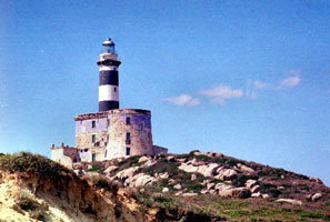
| IT 75 |
Capo San Marco
latitude 39° 51' 36.7" N longitude 8° 26' 3.3" E
The lighthouse is at the end of the narrow Penisola del Sinis, which also features a defensive tower thought to have built in Gothic times, around 500 AD. Located at the end of the SP6 highway, marking the northern entrance to the Golfo di Oristano. ARLHS # SAR-017
Photo courtesy Andrea Utzeri [farisardegna] |
|
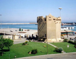
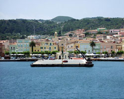
| IT 76 |
| Oristano (Gran Torre di Oristano)
latitude 39° 54' 24" N longitude 8° 30' 58.6" E
The largest of all the Sardinian coastal towers, this historic fort was built in the early 1500s with later additions. Located in Marina di Torre Grande, about 6.5 km west of Oristano at the northern end of the Golfo di Oristano. photo
Photo courtesy Roberta Spiga and Océane Legrand [Sardinia Exclusive] |
| IT 77 |
Capo Frasca
latitude 39° 46' 8" N longitude 8° 27' 20.3" E |
The area surrounding this light is a naval base also used for NATO forces training. Located on the point of Capo Frasca, marking the south side of the entrance to the Golfo di Oristano. ARLHS # SAR-050 |
Southwest Coast
| IT 78 |
La Ghingetta (Portoscuso)
latitude 39° 11' 59.2" N longitude 8° 22' 8.7" E
Located on a rocky reef (Scoglio la Ghinghetta) off the harbor of Portoscuso. Accessible only by boat, but there is an excellent view from ferries leaving Portoscuso for Carloforte on the Isola di San Pietro. ferries
(E 1099) ARLHS # SAR-034
Photo courtesy Arno Siering [ListOfLights] |
|
| IT 79 |
| Isola Piana
latitude 39° 11' 37.9" N longitude 8° 19' 9.9" E
Piana is a small island off the northeastern corner of the Isola di San Pietro. Located on the northern tip of the island, marking the northwestern entrance to the Canale di San Pietro, the channel between the Isola di San Pietro and the mainland of Sardinia. Accessible only by boat. ARLHS # SAR-025
Photo courtesy Egido Ferrighi [fari] |
| IT 80 |
Duono (Carloforte Entrance Range Front)
latitude 39° 8' 44" N longitude 8° 18' 19.1" E
Located in the center of Carloforte, the principal town of the Isola di San Pietro. The island is accessible by ferry from Portoscuso. Note the front range is a pillar and the back range is a light in the building. ferry ARLHS # SAR-044
Photo courtesy cinghius [webshots] |
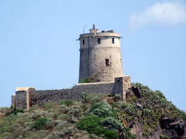
|
| IT 81 |
| Capo Sandalo
latitude 39° 8' 50.9" N longitude 8° 13' 25.9" E
This magnificent lighthouse marks the southwestern corner of Sardinia. The lighthouse is (or was recently) staffed. Located at the end of the SP104 highway on the northwestern coast of the Isola di San Pietro. ARLHS # SAR-018
Photo courtesy Andrea Utzeri [farisardegna] |
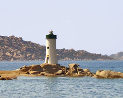
| IT 82 |
Scoglio Mangiabarche
latitude 39° 4' 35.6" N longitude 8° 20' 42.6" E
Located off the northwest point of the Isola di Sant'Antioco, marking the 2.4 km wide channel between that island and the Isola di San Pietro. Accessible only by boat, although there is a good view from the shore. ARLHS # SAR-038
Photo courtesy killerfra [webshots] |
|
| IT 83 |
| Ponte Romano (Sant'Antioco)
latitude 39° 3' 29.9" N longitude 8° 28' 26" E
The modern crossing is a causeway with a short bridge at the Sant'Antioco end. The original Roman bridge is also visible. The lighthouse is located near the center of the causeway, beside the SS126 highway. ARLHS # SAR-045
Photo courtesy Andrea Utzeri [farisardegna] |
| IT 84 |
Isolotto Il Toro |
Il Toro is the tallest of three small islands about 10 km due south of Capo Sperrone, the southern tip of the Isola di Sant'Antioco. Accessible only by boat. |
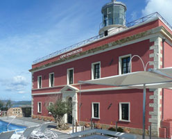
| IT 85 |
Capo Spartivento
latitude 38° 52' 40" N longitude 8° 50' 45.1" E
This famous lighthouse marks the southernmost tip of Sardinia. The building has now been converted to a hotel and renovated. Located on the point of the cape about 3 km southwest of Chia. Accessible by road. Note: there is another Capo Spartivento, also with a famous lighthouse, at the southern tip of the Italian mainland in Calabria. IT 50
Photo courtesy Paolo Rossi [CharmingSardinia] |
|
|
|
Southeast Coast
| IT 86 |
| Pula (Capo di Pula, Torre di Sant'Efisio, Torre del Coltellazzo)
latitude 38° 59' 3" N longitude 9° 1' 12.5" E
The light marks the western entrance to the Golfo di Cagliari. Located on a promontory overlooking the harbor of Pula. Readers should note that this great big tower mounts a very small red light on the front corner. (E 1070) ARLHS # SAR-012
Photo courtesy Arno Siering [ListOfLights] |
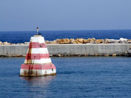
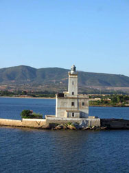
| IT 87 |
Cagliari Molo di Ponente (West Breakwater)
latitude 39° 12' 4.7" N longitude 9° 6' 39.3" E
A new harbor has been built recently at Cagliari, but this lighthouse is located at the end of the west breakwater of the traditional (eastern) harbor. Accessible by walking the mole. ARLHS # SAR-041 |
|
| IT 89 |
Capo Sant'Elia
latitude 39° 11' 2.9" N longitude 9° 8' 53.5" E
This traditional landfall light for Cagliari is located on a promontory on the southeast side of the city, at the end of the Via Faro. ARLHS # SAR-019
Photo courtesy Andrea Utzeri [farisardegna] |
|
| IT 90 |
| Capo Carbonara
latitude 39° 6' 13.3" N longitude 9° 30' 49.4" E
Capo Carbonara, the southeastern corner of Sardinia, is jutting out from the coast at San Stefano. Located just southeast of the town. ARLHS # SAR-010
Photo courtesy alwaysstone [Flickr] |
| IT 91 |
Isola dei Cavoli
latitude 39° 5' 19.2" N longitude 9° 32' 0.5" E
The Isola dei Cavoli (Island of Cabbages) is a rocky 40 hectare (100 acre) island about 800 m southeast of Capo Carbonara. The island is a research reserve administered by the Università di Cagliari. Located on the highest point of the island. Accessible only by boat, there are good views from the Capo Carbonara lighthouse. ARLHS # SAR-001
Photo courtesy Andrea Utzeri [farisardegna] |
|
| IT 92 |
| Capo Ferrato
latitude 39° 17' 58.2" N longitude 9° 37' 59.9" E
The house has been privately owned since the lighthouse was automated in 1976. Located at the end of a very sharp promontory about 14 km northeast of Castiadas and 25 km north of Capo Carbonara. ARLHS # SAR-013
Photo courtesy Sabrina Onano [farisardegna] |
NorthEast Coast
| IT 93 |
Capo Bellavista
latitude 39° 55' 49.7" N longitude 9° 42' 47.6" E
Located on a high promontory at Arbatax on the central east coast of Sardinia, accessible by the many switchbacks of the Via Faro Bellavista. ARLHS # SAR-011
Photo courtesy Daniel Witting [Flickr] |
|
| IT 94 |
| Capo Comino
latitude 40° 31' 42.6" N longitude 9° 49' 39.1" E
This lighthouse replaced an earlier light built much higher on the cape. Located on the point of the cape, about 15 km southeast of Siniscola.
Photo courtesy Andrea Utzeri [farisardegna] |
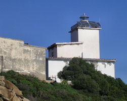
| IT 95 |
Tavolara (1861) (Isola di Tavolara)
latitude 40° 55' 28.3" N longitude 9° 43' 59.6" E |
The island, formerly a penal colony, is now an upscale resort accessible by passenger ferry from Porto San Paolo. This lighthouse, built by prisoners, had a focal plane height of 164 m and was too high on a precipitous slope to be easily maintained. Located high above the eastern end of the island, accessible by hiking trails. ARLHS # SAR-049 |
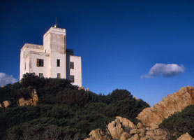
| IT 96 |
Tavolara(1920) (Isola di Tavolara, Punta Timone)
latitude 40° 55' 34.4" N longitude 9° 44' 7.9" E |
Located on Punta Timone at the extreme northeastern tip of the Isola di Tavolara. Probably accessible only by boat. ARLHS # SAR-037 |
| IT 97 |
Isola della Bocca
latitude 40° 55' 14.2" N longitude 9° 34' 0.2" E
Located on a small island at the mouth (bocca) of the estuary forming the Porto di Olbia. Accessible only by boat, but there are excellent views from the south shore of the estuary at Lido del Sole, 400 m away. ARLHS # SAR-024
Photo courtesy Egido Ferrighi [fari] |
|
| IT 98 |
| Isolotto Figarolo
latitude 40° 58' 44.5" N longitude 9° 38' 40.2" E
Figarolo is a small, steeply mountainous island on the north side of the entrance to the Golfo di Olbia and the east side of the entrance to the smaller Golfo di Aranci. Accessible only by boat. ARLHS # SAR-027
Photo courtesy Egido Ferrighi [fari] |
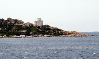
| IT 99 |
Capo Figari
Located on the point of the cape about 7 km southeast of Golfo Aranci. This probably is not a lighthouse, but a signal station.
Photo courtesy Egido Ferrighi [fari] |
|
| IT 100 |
| Capo Ferro
latitude 41° 9' 18" N longitude 9° 31' 24" E
Capo Ferro is at the northeastern corner of Sardinia, in the heart of the beautiful coast called the Costa Smeralda. Located above the point of the cape, about 8 km northwest of Porto Cervo. ARLHS # SAR-015
Photo courtesy fernrouleau [webshots] |
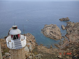
| IT 101 |
Canale della Bisce (Capo Ferro Northeast)
latitude 41° 9' 24.1" N longitude 9° 31' 35.1" E
This little lighthouse and the next one below guide ships through the narrow Bisce Channel (Canale della Bisce) between Capo Ferro and the Isola della Bisce. Located one the point of Capo Ferro, 320 m northeast of the main lighthouse. (E 1003) ARLHS # SAR-014
Photo courtesy marinas.com [Marinas.com] |
|
| IT 102 |
| Isola della Bisce
latitude 41° 9' 42.1" N longitude 9° 31' 30" E
This light is on the north side of the Canale della Bisce, which is only about 500 m wide. Located on the south shore of the Isola della Bisce. (E 1000) ARLHS # SAR-002
Photo courtesy marinas.com [Marinas.com] |
| IT 103 |
Isolotti Monaci
latitude 41° 12' 57.8" N longitude 9° 31' 0.9" E |
The Isolotti Monaci are a group of dangerous rocks about 2.5 km east of the Isola di Caprera and 8 km north of Capo Ferro. Located atop the largest rock. Accessible only by boat. photo ARLHS # SAR-005 |
| IT 104 |
Capo d'Orso
latitude 41° 10' 39.5" N longitude 9° 25' 23.6" E
Located on the point of the cape about 4 km east of Palau. Note: there is another Capo d'Orso lighthouse at Amalfi. (E 0992) ARLHS # SAR-043
Photo courtesy Arno Siering [ListOfLights] |
|
| IT 105 |
| Palau (Punta Palau, Punta Faro)
Palau is the ferry terminal for ferries serving the Arcipelago di la Maddalena and the national park encompassing those islands. The lighthouse is located on rocks just off a promontory northwest of the harbor of Palau. (E 0988) ARLHS # SAR-035
Photo courtesy sabricolombo [Flickr] |
| IT 106 |
Punta Sardegna
latitude 41° 12' 24.5" N longitude 9° 21' 46.4" E
Located on a promontory about 8 km northwest of Palau. (E 0950) ARLHS # SAR-036
Photo courtesy Egidio Ferrighi [ListOfLights] |
|
|
|
 Corsica


