|
This page shows the lights of Albania. Apparently not a good tourist area as there are almost no pictures. Most of this page is based on the Amateur Radio Lighthouse Society database. w8 Data augmented with thoughts from Russ Rowlett via his Lighthouse Directory. w4 |
|
| AL 1 |
Kep i Palermos
latitude 40° 2' 59.7" N longitude 19° 47' 37.9" E |
Located on a prominent cape about 15 km southeast of Himarë. (E 3734) ARLHS # ALB-001 |
| AL 2 |
Thalassa Khimarras |
ARLHS # ALB-018 |
| AL 3 |
Kep i Gjuhezes
latitude 40° 25' 22.2" N longitude 19° 17' 36.6" E |
This tower was presumably built by the military, but whose military and for what purpose is unknown. Located on the northwestern tip of the Karaburun peninsula, south of Sazan Island. (E 3732.5) ARLHS # ALB-008 |
| AL 4 |
Kepi i Gallovecit |
ARLHS # ALB-007 |
| AL 5 |
Shen Vasilit (Sqepi i Sevasinit)
latitude 40° 22' 33.5" N longitude 19° 24' 16.4" E |
Located on a rugged east coast of the Karaburun peninsula about 8 km north of Orikum on the west side of the Gji i Vlorës. (E 3732) ARLHS # ALB-015 |
| AL 6 |
Gji Dukatit (Kep i Pasha Liman, Sqepi Orikum)
latitude 40° 19' 40.2" N longitude 19° 25' 12" E |
Located on a headland sheltering the small port of Orikum, at the southern end of the Gji i Vlorës. photo (E 3731) ARLHS # ALB-013 |
| AL 7 |
Kep i Kalaja ( Kalase)
latitude 40° 24' 54.4" N longitude 19° 28' 51.5" E |
Located on a precipitous headland on the south side of Vlorë. photo (E 3729.5) ARLHS # ALB-010 |
| AL 7E |
Vlorë East Mole ( Kalase)
latitude 40° 26' 54.1" N longitude 19° 29' 3" E |
This harbor is the terminal for ferries crossing the Strait of Otranto from Brindisi, Italy. Located at the end of the east breakwater of Vlorë. photo (E 3729) |
| AL 7W |
Vlorë West Mole
latitude 40° 26' 57.4" N longitude 19° 28' 49.9" E |
Located at the end of the west breakwater of Vlorë. (E 3729) |
|
|
| AL 8S |
Sarandë (Gjiri Sarandës, Lëkurës) |
This lighthouse is a short distance south of the 16th century Lëkurësi Castle, now the site of a popular restaurant. Located on the heights above Sarandë (Saranda), a port and tourist center facing the north end of the Greek island of Kérkyra (Corfu).
Picture seen from the Ferry (E 3742.3) |
| AL 8S |
Sarandë
This lighthouse is a short distance south of the 16th century Lëkurësi Castle, now the site of a popular restaurant. Located on the heights above Sarandë (Saranda), a port and tourist center facing the north end of the Greek island of Kérkyra (Corfu)
View seen from the ferry (E 3742.3)
Photo courtesy Michael Fruehmann [Flickr] |
|
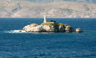
Sazan Island
| AL 9 |
Ishull i Sazanit (Saseno) |
Sazan Island, known as Saseno in Italian, is located strategically in the mouth of the Gji i Vlorës, Vlorë Bay. For a while this was a Soviet air base and is still a restricted military area. The light is located at the northwestern tip of the island. photo (E 3723) ARLHS # ALB-004 |
| AL 9J |
Kepi i Jugor
latitude 40° 28' 26.2" N longitude 19° 17' 7.7" E |
Located on the southern tip of Sazan Island. ARLHS # ALB-009 |
| AL 10 |
Sazan Shen Kollit Nokole Mole North (green)
latitude 40° 30' 11" N longitude 19° 17' 7.6" E |
ARLHS # ALB-019 |
| AL 11 |
Sazan Shen Kollit Nokole Mole South (red)
latitude 40° 30' 7.4" N longitude 19° 17' 7.4" E |
ARLHS # ALB-020 |
| AL 12 |
Kepi i Treporteve
latitude 40° 30' 43" N longitude 19° 23' 45.9" E |
Located on the northeast side of the entrance to the Gji i Vlorës, about 8 km east of Sazan Island and the same distance northwest of Vlorë. photo (E 3737) ARLHS # ALB-003 |
| AL 11N |
Triporti North Breakwater
latitude 40° 29' 1.2" N longitude 19° 26' 0.4" E |
Located at the end of the south breakwater at a small harbor about 6 km northwest of the main Vlorë harbor. (E 3737.7) ARLHS # ALB-003 |
|
|
| AL 11S |
Triporti South Breakwater
latitude 40° 28' 56.3" N longitude 19° 26' 0.6" E |
Located at the end of the north breakwater at a small harbor about 6 km northwest of the main Vlorë harbor. photo (E 3737.6) ARLHS # ALB-003 |
| AL 13 |
Lume Vijose |
ARLHS # ALB-011 |
Vjosë
| AL 14 |
Vjosë (Vijose, Lume Vijose) |
Located just north of the Vjosë River entrance near Bishan. photo (E 3719) ARLHS # ALB-014 |
Durrës County
| AL 15 |
Karavastase |
ARLHS # ALB-006 |
| AL 16 |
Kep i Lagit
latitude 41° 8' 45.2" N longitude 19° 26' 14.4" E |
Kep i Lagit is the promontory at the south end of the Gji i Durrësit (Durres Bay), about 15 km across the bay due south of Durrës. Located on the point of the cape. photo (E 3719) ARLHS # ALB-014 |
| AL 17 |
Durrës South Mole
latitude 41° 18' 8.9" N longitude 19° 27' 19.8" E |
Located at the end of the breakwater quay of Durrës harbor. photo (E 3712) |
| AL 18 |
Durrës East Mole
latitude 41° 18' 15.5" N longitude 19° 27' 23.9" E |
Located at the end of the east breakwater. (E 3714) |
| AL 19 |
Kep i Durrësit
latitude 41° 18' 55.6" N longitude 19° 26' 8.4" E |
Kep i Durrësit (Cape Durres) is a headland sheltering the harbor of Durrës, Albania's principal port of entry. Located on the heights above the palace of King Zog I, which is one of the best known attractions in Durrës; visitors report it is possible to walk a short distance uphill from the palace to find the lighthouse. photo (E 3711) ARLHS # ALB-002 |
| AL 20 |
Kep i Palit
latitude 41° 24' 51.1" N longitude 19° 23' 56.4" E |
The Albanian Naval Force has a base at an artificial harbor in the lee of the cape. Located on a sharp promontory on the northwest side of Durrës. (E 3708) ARLHS # ALB-005 |
| AL 21 |
Kep i Rodonit Cape Rodini
latitude 41° 35' 14.5" N longitude 19° 26' 42.6" E |
Rodonit is a sharp, mountainous cape that projects about 8 km into the Adriatic Sea in northern Albania. We don't know if anything survives of the Ottoman lighthouse. Located on the heights above the cape. (E 3705) ARLHS # ALB-016 |
Shkodër County
| AL 22 |
Kep i Shengjinit |
Located on a cape sheltering the harbor of Shengjin, a town about 20 km east southeast of the Montenegrin border. photo (E 3702) ARLHS # ALB-017 |
| AL 23 |
Mali Renzit |
ARLHS # ALB-012 |
|
|
 Montenegro