|
This page displays the lights on the Georgian Bay of Lake Huron, thus they are all in Ontario. While we have show geographic coordinates for these lights, many of them are not accessible by auto, so you may have to visit the tourist marinas to see if you can find someone to take you close enough to see these lights. Sequence numbers are taken from Great Lakes Lighthouses American & Canadian Wes Oleszeski, Avery Press, 1998 |
|
| 40 |
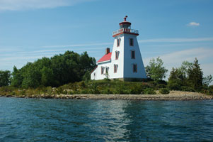
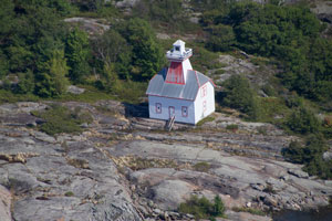
Strawberry Island (ON 46)
latitude 45° 58' 24.2" N longitude 81° 51' 15.5" W
access: boat
This photo is taken from a boat. If you follow Highway 17 west from Sudbury, then follow Highway 6 south through Espinosa, you can see the light across the North Channel while on Greater La Cloche Island.
Accessible by boat only ARLHS # CAN-483
Photo courtesy Sam MacCutchan [Flickr] |
|
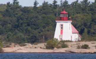
| 41 |
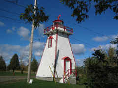
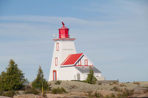
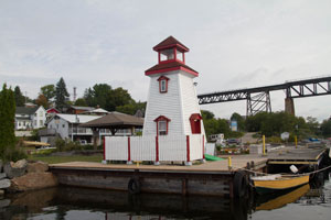
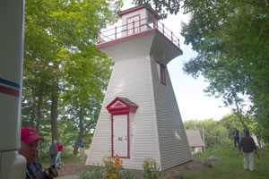
| Manitowaning (ON 47)
October 12, 2003 access: car
This light is right downtown in Manitowaning, just below St. Paul's Episcopal Church. Marnie commented that these lights "all look pretty much the same" and there sure is a pattern to their construction. ARLHS # CAN-302 |
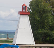
| 41.5 |
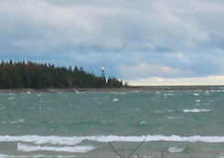
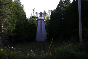
Providence Bay (ON 48)
October 12, 2003 access: car + long lens
This light is not in Wes book. We learned about it from the table (which reproduced a tourist map) when we ate breakfast. You can't get very close, this picture is from the harbor of Providence Bay (and has a heavy digital zoom). There's another light allegedly at the tip of the North side of the island in the Indian Reservation. We didn't attempt to get there. p1 ARLHS # CAN-416 |
|
| 42 |
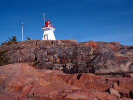
| Killarney East (ON 49)
access: car
Take highway 637 into Killarney, then follow Ontario street to the end. ARLHS # CAN-262
Photo courtesy © R. G. Daniel [rgdaniel] |
| 43 |
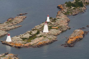
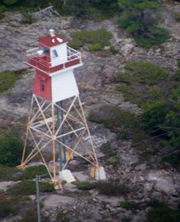
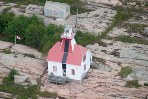
Gereaux Island (ON 50)
latitude 45° 44' 40" N longitude 80° 39' 32.5" W
September 9, 2016 access: boat
Boat (but visitors are welcome) ARLHS # CAN-197 |
|
| 43.3 |
| Bustard Rocks (ON 50B)
latitude 45° 53' 30.7" N longitude 80° 57' 6.5" W
September 7, 2016 access: boat
Located on a small rocky island west of the main Bustard Island, on the approaches to the French River. |
| 43.6 |
Key Harbor (ON 50K)
September 7, 2016 access: boat
I haven't learned much about this light. Locals tell me it's a Private Aid to Navigation (PAN) and has been here for many years. |
|
| 44 |
| Byng Inlet Front (ON 51)
September 7, 2016 access: boat
Located on the south side of the channel inside the entrance of Byng Inlet. Boat required. ARLHS # CAN-066 |
| 44 |
Byng Inlet Rear (ON 51R)
September 7, 2016 access: boat
Located on the south side of the channel inside the entrance of Byng Inlet. Boat required. |
|
| 45 |
| Pointe au Baril (ON 52)
September 7, 2016 access: boat
A tourist town, shouldn't be hard to find. Located on the point, off ON 69 about 65 km north of Parry Sound.
There is also a rear range light on Macklin Island about 1.5 km east which is accessible only by boat. ARLHS # CAN-393 |
| 45.5 |
Pointe au Baril Rear Range (ON 52R)
latitude 45° 33' 20.7" N longitude 80° 29' 8" W
September 7, 2016 access: Boat
Across the channel from the main light
the rear range light is on Macklin Island about 1.5 km east which is accessible only by boat. |
|
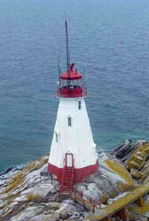
| 46 |
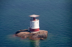
| Red Rock (ON 53)
latitude 45° 21' 36" N longitude 80° 24' 29" W
September 7, 2016 access: boat
At the entrance of Parry Sound (yes, that is a heli-pad on the top, the rock is too small for both the light and a helicopter pad.) ARLHS # CAN-429 |
|
|
| 47 |
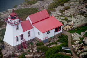
Snug Harbour (ON 54)
latitude 45° 22' 25.6" N longitude 80° 18' 40.5" W
September 7, 2016 access: boat
Drive down Highway 5559 to Snug Harbour road. Drive to the Marina at the end and beg a ride. ARLHS # CAN-463 |
|
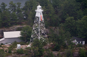
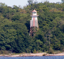
| 47.1 |
| Snug Harbour Rear Range (ON 54F)
September 7, 2016 access: boat
Across the channel from Snug Harbor on Walton Island is this metal skeletal tower |
| 47.4 |
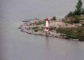
Killbear Point (ON 54K)
latitude 45° 19' 57.4" N longitude 80° 10' 11.9" W
September 7, 2016 access: car?
On the point near the campground, this is a simple D9 (sewer pipe) installation |
|
| 47.6 |
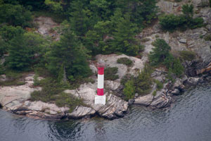
| Three Mile Point (ON 54T)
latitude 45° 20' 45" N longitude 80° 5' 21.2" W
September 7, 2016 access: plane
On the point just north of Depot Harbor, this is a simple D9 (sewer pipe) installation. |
| 47.7 |
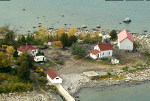
Cape Robert (relocated) (ON 54S)
latitude 45° 20' 40.7" N longitude 80° 2' 31.1" W
September 8, 2016 access: car
This is just the lantern room from the top of the Cape Robert light. It is now serving as the front entrance to the Parry Sound Coast Guard Station |
|
| 47.8 |
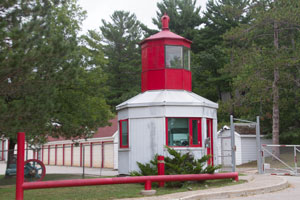
| Chippewa III (faux) (ON 54X)
latitude 45° 20' 23.5" N longitude 80° 2' 3.5" W
September 7, 2016 access: car
In the harbor at Parry Sound, this is the base station for the Chippewa III. It looks like authentic construction, so probably moved, but from where is unknown. Some people identify this is a PAN (Private Aid to Navigation). |
| 47.85 |
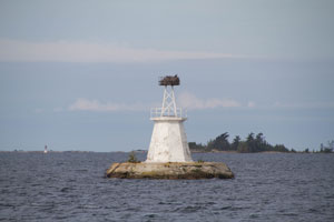
Spruce Rock (ON 55C)
latitude 45° 19' 54.9" N longitude 80° 15' 32.8" W
September 10, 2016 access: boat
No longer in service. Complete with Osprey net on top. |
|
| 47.9 |
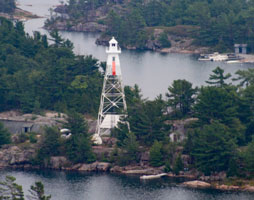
| Jones Island Front Range (Gordon Rock) (ON 55F)
latitude 45° 18' 55.5" N longitude 80° 16' 57" W
September 10, 2016 access: boat
A standard 4 sided pyramid Canadian light about 1km from Jones Island ARLHS # CAN-1033 |
| 48 |
Jones Island Rear Range (ON 55)
latitude 45° 17' 58.2" N longitude 80° 15' 25.1" W
September 7, 2015 access: boat
There is also a Front range located on Gordon Rocks (about 2.5 miles north) ARLHS # CAN-257 |
|
| 49 |
| Western Island (ON 56)
access: boat
SW of Parry Sound, on Double Top Island ARLHS # CAN-498
Photo courtesy Canadian Coast Guard [LH Directory] |
| 50 |
Brebeuf Island Front Range (ON 57)
latitude 44° 52' 36.1" N longitude 79° 53' 4.6" W
September 8, 2018 access: boat
This range directs Atlantic ocean traffic into the Georgian Bay area near Midland Ontario ARLHS # CAN-058 |
|
|
|
| 50 |
| Brebeuf Island Rear Range (ON 57A)
latitude 44° 52' 22.2" N longitude 79° 54' 1.5" W
September 8, 2018 access: boat
The rear range light is on Beausoleil Island |
| 50.5 |
Midland Front Range (ON 57F)
latitude 44° 52' 36.1" N longitude 79° 53' 4.6" W
September 8, 2018 access: boat or car
Boats coming into Midland use this range to guide them to a harbor on the East side. |
|
| 50.7 |
| Midland Rear Range (ON 57R)
latitude 44° 52' 36.1" N longitude 79° 53' 4.6" W
September 8, 2018 access: boat or car
mostly hidden by trees up the hill from the front range. |
| 51 |
Beausoleil Island (ON 58) |
Take a boat from Pentetang (Midland) or Port Severn.
You can also hike to it by taking a water taxi to Georgian Bay Islands National Park. park ARLHS # CAN-548 |
| 51.3 |
Port McNicols Front Range (ON 58F)
latitude 44° 45' 45" N longitude 79° 50' 1" W
September 8, 2018 access: car ARLHS # CAN-548 |
|
| 51.5 |
| Port McNicols Rear Range (ON 58R)
latitude 44° 44' 31" N longitude 79° 46' 51" W
September 8, 2018 access: car |
| 51.5 |
Victoria Harbour Rear Range (ON 58V)
latitude 44° 44' 48.9" N longitude 79° 46' 38" W
September 8, 2018 access: car
The light is not in service and is well hidden in the woods. There are street signs that lead you to "Range Light". The front range is lost and nobody even knows where it used to be. |
|
| 52 |
| Hope Island (ON 59)
access: boat
This light was removed in 2017. ARLHS # CAN-230
Photo courtesy marinas.com [marinas.com] |
| 53 |
Christian Island (ON 60)
latitude 44° 46' 5.5" N longitude 80° 7' 50.2" W
August 18, 2011 access: ferry + walk (4.1 miles)
Ferry from Cedar Point, Ont. Once on the island, from O Gema Street take your second left, Kate Kegwin Street, and follow it for 4.1 miles to its end, where you will find Christian Island Lighthouse.
Or, you can navigate to Kingswood Acres, and see the light across the water. ARLHS # CAN-136 |
|
| 53.5 |
| Nancy Island Replica (ON 60N)
latitude 43° 11' 5.8" N longitude 80° 1' 19" W
September 7, 2018 access: car
A replica of the light built in the park to commemorate the light
Visible from River Road in Wasaga Beach |
| 54 |
Nottawasaga Island (ON 61)
latitude 44° 32' 18.7" N longitude 80° 15' 31.4" W
September 6, 2018 access: boat
This light was struck by lightning and the surrounding limestone was broken off. It is now surrounded by a temporary barrier until renovation can be done.
This photo is taken before the damage was done. ARLHS # CAN-356
Photo courtesy Ali Brauda [Flickr] |
|
| 54.1 |
| Nottawasaga Island (now) (ON 61n)
latitude 44° 32' 18.7" N longitude 80° 15' 31.4" W
September 6, 2018 access: boat
This light was struck by lightning and the surrounding limestone was broken off. It is now surrounded by a temporary barrier until renovation can be done.
Here is what it looks like now ARLHS # CAN-356 |
| 54.3 |
Collingwood Harbor Replica (ON 61R)
latitude 44° 30' 26.6" N longitude 80° 13' 5.7" W
September 6, 2018 access: car
This is a replica of the Harbor front range light. It is located on the dock at Collingwood Harbor |
|
| 56 |
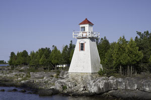
Cape Crocker (ON 63)
latitude 44° 57' 22.9" N longitude 80° 57' 38" W
August 18, 2011 access: car
From Cape Crocker, follow Community Center Road (North) to Harbor Road (right) to Lighthouse road NE 5 miles (2.5 are only dirt) road around the sound. ARLHS # CAN-094 |
|
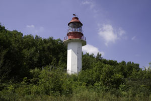
| 57 |
| Lion's Head (ON 64)
latitude 44° 59' 26.2" N longitude 81° 14' 53.5" W
August 18, 2011 access: car
From Hwy 6, follow Bruce Road 9 east at Ferndale to Lion's Head. Turn left and follow signs to harbour. ARLHS # CAN-276 |
| 58 |
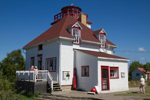
Cabot Head (ON 65)
latitude 45° 14' 42.8" N longitude 81° 17' 31.2" W
August 18, 2011 access: car
The beacon was actually removed in the late 1960s - early 1970s, then restored later on by a preservation group.
Turn east off Highway 6 on the Dyers Bay Road. Follow the road through Dyer's Bay and bear right for the shore road to Cabot Head... follow it to the end. ARLHS # CAN-067 |
|
| 59 |
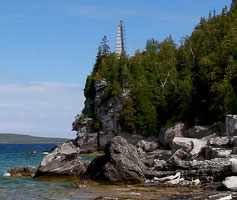
| Flowerpot Island (ON 66)
latitude 45° 18' 25.7" N longitude 81° 36' 51.5" W
access: tour
Plan to spend an entire day on the island, accessible only by tour (fathom five national marine park) boat. ARLHS # CAN-181
Photo courtesy © ontariogal. Used with permission [Flickr] |
| 60 |
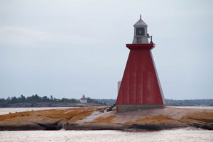
Lonely Island (ON 67)
latitude 45° 34' 25.6" N longitude 81° 28' 5.2" W |
Take a boat from Manotowaning. This is still an active station, so access is closed. ARLHS # CAN-282 |
| 61 |
South Baymouth Front Range (ON 68)
latitude 45° 33' 28.1" N longitude 82° 1' 1.2" W
August 19, 2011 access: car
South Baymouth is the ferry connection point to the other side of Georgian Bay, so this is a significant light for navigation. It is mounted on a shelf of limestone. With the Great Lakes level as low as it is in 2003, it looks pretty isolated, but I'll bet there have been times when water came right up to the base. ARLHS # CAN-591 |
|
| 62 |
| South Baymouth Rear Range (ON 69)
latitude 45° 33' 31.8" N longitude 82° 59.5" W
August 19, 2011 access: car
As you can see, this light is buried in a grove of trees, just cut out so that it is visible from the water. Just behind where I'm standing is some person's house, so they didn't waste any money on real estate with this light. ARLHS # CAN-592 |
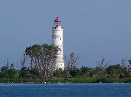
| 63 |
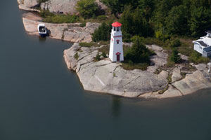
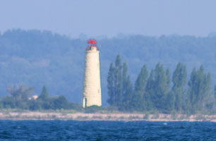
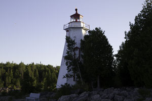
Cove Island (ON 70)
latitude 45° 19' 36.4" N longitude 81° 44' 5.9" W
August 19, 2011 access: ferry
This picture was taken from the deck of our Ferry from Tobermory to Manitoulin Island. It's early morning, so the light is more interesting than some other times. ARLHS # CAN-149 |
|
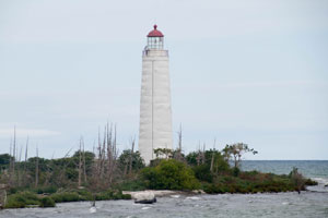
| 64 |
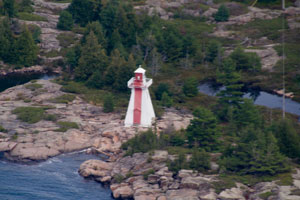
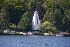
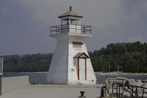
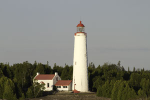
| Big Tub (ON 71)
latitude 45° 15' 27.7" N longitude 81° 40' 21" W
August 19, 2011 access: car
Constructed (like many of these lights) out of wood and placed on a limestone base (actually the same cliff that makes Niagara Falls), this is still the original wood (built in 1920), so it either was very good wood, or very well maintained. If you'd like, the old keepers cottage is for rent. rent ARLHS # CAN-549 |
|
|
If you would like copies of any of my pictures, contact me and we'll discuss arrangements. There are others who do this commercially, I have no intention of competing directly, but you can make a proposal, and I'll react. mailto
 Lake Huron
