|
This page shows the lighthouses on Lake Huron. Downloadable copies of this pictures are stored on the Flickr. These pictures start north of Alpena and end up in Canada. You'll notice a break in the numbers, that break covers the Georgian Bay. The trip October 2003 was not planned, it just happened when Mom and I recognized we had the weekend free. Then we realized we had Columbus Day free as well, so used the time to do around trip of Lake Huron, with a full day on Manatoulin Island. Index numbers are from `Great Lakes Lighthouses American & Canadian p1 |
|
| 0.7 |
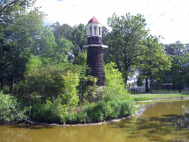
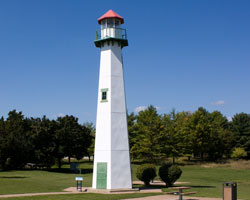
Palmer Park (faux) (MI 111A)
latitude 42° 25' 20" N longitude 83° 6' 42.7" W
September 3, 2010 access: car
Alone on an island in Lake Frances, it is unlikely that any boat will need illumination from this lighthouse. (This is technically a faux light, it has always been decorative, not functional.) |
|
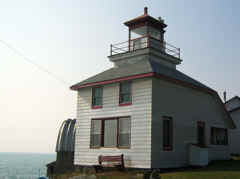
| 1 |
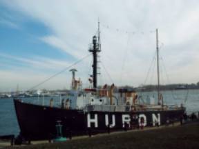
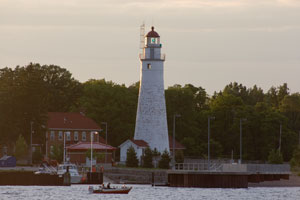
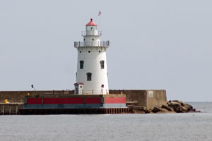
| Huron Lightship (MI 104A)
latitude 42° 59' 22.3" N longitude 82° 25' 35.4" W
January 8, 2000 access: car
Physically located just south of the Port Huron to Sarnia bridge, this was at one time a lightship located in the midst of "trouble". (It is currently beached and a museum that is open during the summer) ARLHS # USA-394 |
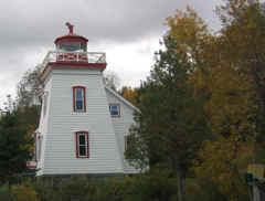
| 1.1 |
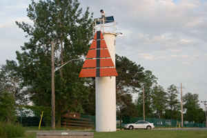
Point Edward Point Front Range (ON 77F)
latitude 43° 9.3" N longitude 82° 24' 59.2" W
June 22, 2008 access: car
Marking the entrance to the St. Clair river; this post with a light on the top is critical for safe navigation into the river. On other side of the river is the Fort Gratiot light MI104 |
|
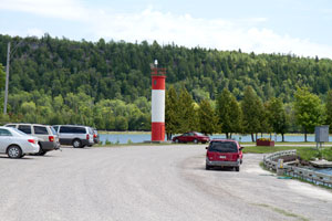
| 1.2 |
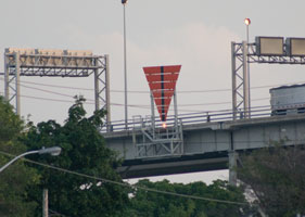
| Point Edward Point Rear Range (ON 77R)
latitude 42° 59' 48.6" N longitude 82° 24' 59.8" W
June 22, 2008 access: car
You will note that the most important part of this is the day mark; but there is a light at the bottom. Note that it physically is mounted on the Blue Water bridge to the US. |
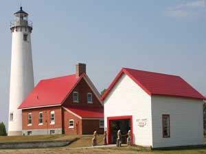
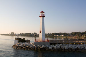
| 2 |
Fort Gratiot (MI 104)
latitude 43° 22.6" N longitude 82° 25' 20.8" W
January 8, 2000 access: car
(still an active coast guard station) This picture was taken from Point Edward (which is just of north of Sarnia, Ontario) ARLHS # USA-291 |
|
| 2.1 |
| Fort Gratiot Front Range (MI 104F)
latitude 42° 59' 36.2" N longitude 82° 25' 38.7" W
December 13, 2008 access: car
It appears that southbound boats first align with the Point Edward lights, then take the turn into the river when the Fort Gratiot lights align. ON77F |
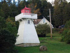
| 2.2 |
Fort Gratiot Rear Range (MI 104R)
latitude 42° 59' 32.1" N longitude 82° 25' 41.5" W
December 13, 2008 access: car
It appears this light was built as part of the condo development which you can see. In 2003; the developer appealed to the City Council for permission to build the matching front range you see above (which is part of the Edison park and leased to the lighthouse organization.) |
|
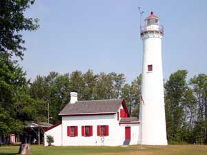
| 3 |
| Port Sanilac (MI 103)
latitude 43° 25' 44.4" N longitude 82° 32' 24" W
August 28, 2006 access: car
This light is one block east of M-25 (and one block south of Main Street.) (The home is currently a private residence; but lighthouse is still operational) ARLHS # USA-651 |
| 4 |
Harbor Beach (MI 102)
latitude 43° 50' 44.3" N longitude 82° 37' 53" W
August 28, 2006 access: car
From Highway 25 (Huron Avenue) in Harbor Beach, turn east on Trescott Street and follow to its end at Bathing Beach Park. A good, distant shot of the lighthouse is available from the end of Trescott pier.
The light is on the end of the breakwater, so technically you could walk up close. The end of the breakwater may not be accessible to the public (we didn't check) and even if it is, it's a long walk. The long lens works better. ARLHS # USA-365 |
|
| 5 |
| Pointe Aux Barques (MI 101)
August 28, 2006 access: car
A lighthouse museum; but still operating in addition
Just north of Port Hope, turn east on Lighthouse Drive. The light is in a county park that is well maintained. ARLHS # USA-615 |
| 6 |
Port Austin Reef (MI 100)
latitude 44° 4' 54.3" N longitude 82° 58' 53.8" W
August 28, 2006 access: boat
2.5 miles north of Port Austin in Lake Huron. As a result, the best way to see this light is in a boat (but it is also dangerous, the light's here for a reason). However, from the downtown pier in Port Austin, you can get pictures using a long lens (and digital zoom). ARLHS # USA-648 |
|
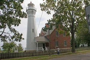
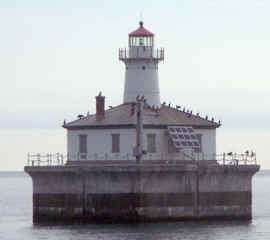
| 7 |
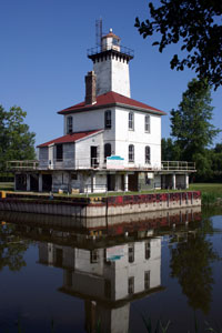
| Saginaw River Rear Range (MI 99)
latitude 43° 38' 7.7" N longitude 83° 51' 1.9" W
July 10, 2004 access: tour
This is was allegedly (probably not) the very first Range Light built in America (said to be designed by the 15 year old son of the Light House Keeper who set up lights on a saw horse, then rowed the boat out to see the effect.) Being on private land, it is difficult to get access without a boat. We saw this as part of a GLLKA special tour. ARLHS # USA-717 |
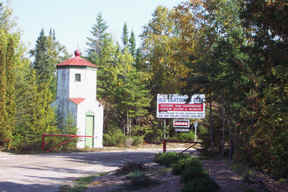
| 7.3 |
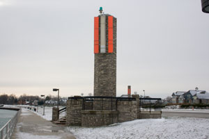
Caseville Harbor Light (MI 99C) |
A private aid to navigation built in 2001.
At the corner of M25 and Main St, go 1 block north. |
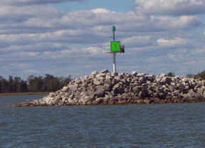
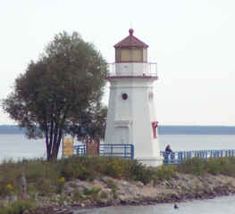
| 8.1 |
Au Gres River South (MI 98A)
latitude 44° 1' 11.4" N longitude 83° 40' 4.2" W
September 15, 2001 access: car
This the "exiting" starboard light at the Au Gres River mouth. |
|
| 8.2 |
| Au Gres River North (MI 98B)
latitude 44° 1' 12.3" N longitude 83° 39' 59" W
September 15, 2001 access: car
This the "returning" starboard light at the Au Gres River mouth. (The key phase to remember is "Red Right Returning".) |
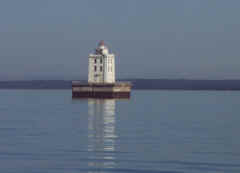
| 8 |
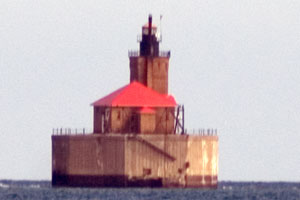
Gravelly Shoal (MI 98)
September 15, 2001 access: boat
Built in 1939, this light is about 6 miles due east of the public lake access at Au Gres. Other than choppy running, it was a very pleasant run out to see a pretty ugly light (built in the Art Deco style quite typical of the 1930's.) ARLHS # USA-340 |
|
| 9 |
| Charity Island (MI 97)
latitude 44° 2' 15" N longitude 83° 26' 27.6" W
September 15, 2001 access: boat or restaurant guest
Built in 1857, this light is on the Northwest corner of Charity Island (about 3 miles east-north-east of Gravelly Shoal). As you can see, it was basically falling apart and sadly in need of repair. By now (2009), the building has been replaced and contains a restaurant. Gravelly Shoal has replaced the light and it has been pretty much ignored since 1939. It
is open for tours and is accessed by ferryboats departing
from either Caseville, MI in the thumb of Michigan
or from E. Tawas, MI
history ARLHS # USA-943 |
|
|
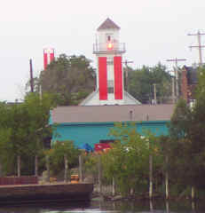
| 9.5 |
Clare Rest Area (faux light) (MI 97A)
latitude 43° 51' 3.6" N longitude 84° 46' 37.2" W
September 3, 2009 access: car
The sign at the light says "In Michigan; we keep the light on for you."
Other interesting information provided is that Michigan comes from an original (not from Europe) American word that means "Great Lake." They also state that the shore line of Michigan is longer than the entire Eastern sea coast. |
|
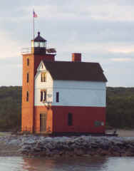
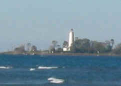
| 10 |
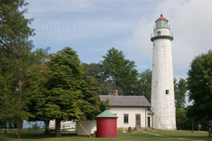
| Tawas Point (Ottawa Point) (MI 96)
latitude 44° 15' 13.3" N longitude 83° 26' 58.2" W
July 29, 2004 access: car
The first light on the point was built in 1853. By the 1870s though, the point had grown so much that it was not effective. This light was built in 1875 and not only is it still an active Coast Guard station, it is open to the public on weekends. ARLHS # USA-837 |
| 11 |
Sturgeon Point (MI 95)
latitude 44° 42' 45.7" N longitude 83° 16' 21.8" W
September 25, 1999 access: car
Established in 1870, this is still an active light. It is fully automated and the government is considering deactivating it. ARLHS # USA-823 |
|
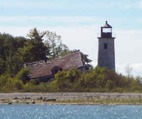
| 12 |
| Alpena (MI 94)
latitude 45° 3' 37.5" N longitude 83° 25' 22.5" W
September 25, 1999 access: car
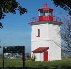
Located right in the middle of Alpena, this is easy to find. Having found it, the natural reaction is "so what?" Note carefully that this is a lighthouse. There is a ladder below the light and room inside to stand up. ARLHS # USA-007 |
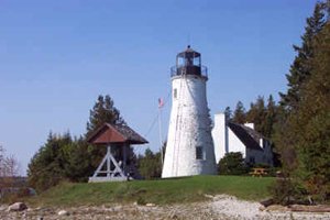
| 13 |
Thunder Bay Island (MI 93)
latitude 45° 2' 14.3" N longitude 83° 11' 39.9" W
access: boat
About the only way to get here is by boat. Alpena is the closest harbor. ARLHS # USA-847
Photo courtesy George Klumb |
|
| 14 |
| Middle Island (MI 92)
latitude 45° 11' 35.7" N longitude 83° 19' 15.2" W
access: boat
Middle Island is 2.5 miles offshore, and roughly 10 miles north of Alpena. ARLHS # USA-495
Photo courtesy George Klumb |
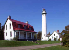
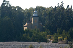
| 15 |
Presque Isle Harbor Front Range (MI 91)
latitude 45° 20' 17.1" N longitude 83° 29' 29.9" W
October 3, 2001 access: car
Before the front range light was restored by the Robert Burseky family in 2004, it stood alongside the road near the Old Presque Isle Lighthouse. relocated to
From Highway 23, turn east on Grand Lake Road. The range lights are located alongside Grand Lake Road just before the Presque Isle Marina. ARLHS # USA-669 |
|
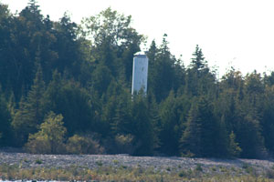
| 16 |
| Presque Isle Harbor Rear Range (MI 90C)
latitude 45° 20' 16.9" N longitude 83° 29' 38.5" W
access: car
The original rear range light is behind the modern rear range light. This is a private residence but can be seen from the public parking lot. |
| 17 |
Presque Isle (old) (MI 90)
latitude 45° 20' 31.2" N longitude 83° 28' 40.8" W
October 3, 2001 access: car
An interesting lighthouse in that the bottom of the tower is stone (and conical) while the top is brick (and cylindrical). Now out of service and privately owned, but available to the public. ARLHS # USA-668 |
|
| 18 |
| Presque Isle Point (MI 89)
latitude 45° 21' 23.8" N longitude 83° 29' 31.2" W
October 3, 2001 access: car
An automated light, it is still open to the public May to October ARLHS # USA-667 |
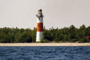
| 19 |
Forty Mile Point (MI 88)
latitude 45° 29' 9.4" N longitude 83° 54' 49.2" W
November 24, 2000 access: car
Six miles north of Rogers City on US23, established in 1896, this light is still active ARLHS # USA-303 |

|
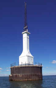
| 20 |
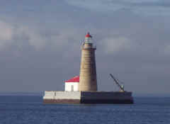
| Spectacle Reef (MI 87)
latitude 45° 46' 27.9" N longitude 84° 8' 10.4" W
September 2, 2003 access: boat
Called "Spectacle", because the reef underneath is in two circles that look like eyeglasses, this is tough to get close to. This picture was taken from the Shepler lighthouse cruise with "the long lens", then digitally zoomed in to get this picture. Sheplers ARLHS # USA-782 |
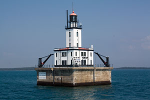
| 21 |
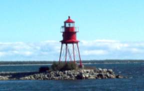
Poe Reef (MI 86)
August 18, 2001 access: boat
Built in 1929, this replaced a lightship that had been here since 1893. This passage has become heavily traveled by powered ships. Most sailing boats used the other side of the Bois Blanc (Bob-Lo) Island. ARLHS # USA-610 |
|
| 22 |
| Fourteen Foot Shoal (MI 83)
August 18, 2001 access: boat
Allegedly the first unmanned light, this was built in 1930 but the operators stayed at Poe Reef (above). These two lights indicate the path through the south passage below Bois Blanc Island ARLHS # USA-306 |
| 23 |
Bois Blanc Island (MI 82)
latitude 45° 48' 37.9" N longitude 84° 25' 15.2" W
September 8, 2009 access: boat
This light is currently a private residence and is almost invisible from most of the lake. The trees that surround it clearly have grown since the light was removed from service or it wouldn't have been of much value. ARLHS # USA-068 |
|
|
|
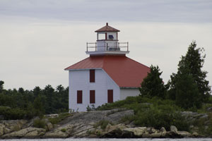
| 23.1 |
| Bois Blanc Island (new) (MI 82n)
latitude 45° 48' 40.7" N longitude 84° 25' 14.4" W
September 8, 2009 access: boat
This is the now operating light on the Island. It's just a few yards north of the one above. Dick (our tour guide) calls this a "sewer pipe" lighthouse, because it looks like a piece of sewer pipe put on end. MI82 |
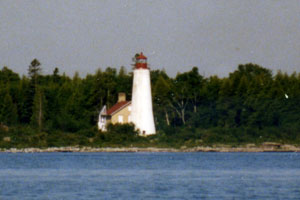
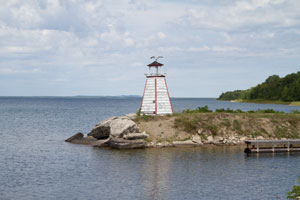
| 24 |
Cheboygan Crib (MI 84)
latitude 45° 39' 24.5" N longitude 84° 27' 54" W
August 18, 2001 access: car
Originally marking the water inlet for the city of Cheboygan, this light has been replaced and moved into a county park. It won't cost much to make it look nice, and the Lighthouse Keeper's Association is trying to raise those funds. ARLHS # USA-160 |
|
| 25 |
| Cheboygan River Front Range (MI 85)
August 18, 2001 access: car
In 1880, they dredged the Cheboygan River and built this front/rear range pair of lights to guide you in the narrow dredged passage. Still operating today, we used the lights to navigate to the bridge as part of our Shepler's tour. ARLHS # USA-162 |
| 25.5 |
Cheboygan Main (ruins) (MI 84M) |
|
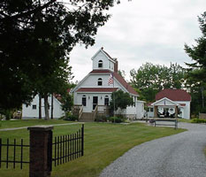
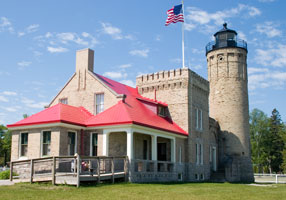
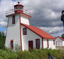
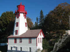
| 26 |
Mackinac Point Old (MI 80)
latitude 45° 47' 14.8" N longitude 84° 43' 44.9" W
July 8, 2006 access: car
Once the Mackinaw bridge was built, this light became obsolete as a navigation item. The building has been extensively renovated and now is open as a museum.
The light is next to the bridge access road and across the street from the GLLKA offices. ARLHS # USA-463 |
|
| 27 |
| Round Island (MI 81)
latitude 45° 50' 13.9" N longitude 84° 36' 59.7" W
August 18, 2001 access: boat or ferry
This is the original lighthouse for Mackinaw Island Harbor, now abandoned but recently (1980s) renovated. If it had not been renovated, it would have fallen down as the front corner of the building had been totally removed by storms. ARLHS # USA-1239 |
| 28 |
Round Island Passage (MI 81B)
latitude 45° 50' 34.8" N longitude 84° 36' 54.6" W
August 18, 2001 access: ferry
This is the new lighthouse for Mackinaw Island Harbor. It's on the opposite side of the channel as well as newer. The interesting issue is that the boat going to St. Ignace go on the shore side of the lighthouse - so - why is it here? ARLHS # USA-710 |
|
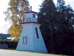
| 28.5 |
| St. Ignace Harbor (MI 81S)
latitude 45° 51' 57.5" N longitude 84° 42' 55.3" W
September 9, 2009 access: car + walk
Moved here from the Monroe Rescue Area; this light has now been registered as a private aid to navigation. It marks the entrance to the marina. |
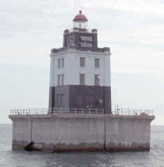
| 29 |
Martin's Reef (MI 38)
latitude 45° 54' 47.3" N longitude 84° 8' 55.3" W
September 2, 2003 access: boat
Physically a duplicate of Poe's reef (see above), this light marks the corner for the boats going into the Dolomite mines on the Upper Peninsula. When you see, it you say "what the big deal?" Looking at the charts, it's clear why it's here. MI 86
Note that the water's so still you can see the reflection of the tower. ARLHS # USA-480 |
|
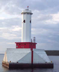
| 30 |
| DeTour Reef (MI 37)
latitude 45° 56' 56.8" N longitude 83° 54' 11.9" W
September 8, 2009 access: boat
A significant light marking the entrance to the St. Mary's river. Last time, we were in full fog. This time it was beautiful (as you can see). Tours of the light are available from the village of DeTour. ARLHS # USA-226 |
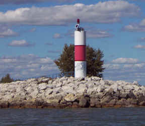
| 31 |
Shoal Island (ON 37)
latitude 46° 18' 48" N longitude 84° 4' 32.3" W
August 20, 2011 access: car
The original Shoal Island Lighthouse was built in 1881 and destroyed by fire around 1909, which led to the construction of the current structure. Located on Shoal Island, near the northwest end of Joseph Island.
From Highway 17, 30 miles east of Sault Ste. Marie, turn south onto Highway 548, 20th Side Road, which leads to St. Joseph Island. Once on the island, take your first right onto D Line Road, and the turn right on Richard Street to reach the town of Richards Landing. Turn left onto Russel Street and then right onto B Line Road. The Shoal Island Lighthouse is just offshore from the end of B Line Road. lhFriends ARLHS # CAN-588 |
|
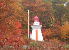
| 32 |
| Wilson Channel Front Range (ON 38)
latitude 46° 19' 20" N longitude 83° 59' 18.5" W
August 20, 2011 access: car
Wilson Channel is the deep water channel from the St. Mary's River in the North Channel above St. Joseph's Island. The best view of this light is from higway 548 on the bridge to the Island. ARLHS # CAN-599 |
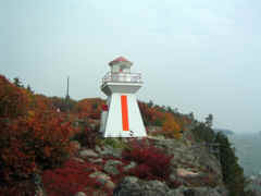
| 33 |
Wilson Channel Rear Range (ON 39)
latitude 46° 19' 26" N longitude 83° 59' 16.8" W
October 11, 2003 access: car
As you can see from the background, the color was just gorgeous on the day we visited these lights. ARLHS # CAN-600 |
|
| 34 |
West Sister Rock (ON 40) |
Access is by boat only. The lighthouse can be seen from tours offered by Mackinac Seaplane Tours call (906) 632-9746. tours ARLHS # CAN-528 |
| 35 |
McKay Island (ON 41)
October 11, 2003 access: car
This is currently a private residence, available for rent. It was built in 1907 and was built to support the timber industry in the area. We just happened to see a sign to it off of PH 17 and took a short detour, and there it was. cottages ARLHS # CAN-311 |
|
| 36 |
| Mississaugi Strait (ON 42)
latitude 45° 53' 28.7" N longitude 83° 13' 31" W
August 19, 2011 access: car
Mississagi Lighthouse Road off Highway 540 (May to September). evergreen resort ARLHS # CAN-322
Photo courtesy georgeeh [Webshots] |
| 37 |
Great Duck Island (ON 43)
latitude 45° 38' 33.2" N longitude 82° 57' 45.4" W |
Off southwestern Manitoulin Island ARLHS # CAN-1032 |
| 38 |
Gore Bay (Janet Bay) (ON 44)
latitude 45° 56' 40.9" N longitude 82° 28' 58.8" W
August 19, 2011 access: car
This light is right at the entrance to a campground, and when camping is in season, it is the registration place. The light is still in use, but fully automated, and the rest of the house is a private residence.
Go to the Gore Bay Marina and follow Water Road to the lighthouse. ARLHS # CAN-203 |
|
| 38 |
| Gore Bay Marina (ON 44A)
latitude 45° 55' 21" N longitude 82° 27' 37" W
August 19, 2011 access: car
This is a "sewer pipe" light and it marks the entrance to the Marina at Gore Bay |
| 39 |
Kagawong (ON 45)
latitude 45° 54' 35.5" N longitude 82° 15' 37.1" W
August 19, 2011 access: car
This light is right at the Marina, but if you're looking at the water, you'll miss it, because I'm standing in the road shooting the picture up at the lighthouse. ARLHS # CAN-259 |
|
| 39.1 |
| Kagawong Marina (ON 45A)
latitude 45° 54' 37.1" N longitude 82° 15' 26.2" W
August 19, 2011 access: car
It's not clear if this is abandoned here, or intentionally left here as a day mark. It marks the entrance to the marina. |
Note the the lights between 40 and 67 are part of the Georgian Bay Page
| 65 |
Chantry Island (ON 72)
latitude 44° 29' 21.5" N longitude 81° 24' 7" W
October 13, 2003 access: car + long lens
This picture is taken from the base of the light below, then digitally zoomed. Clearly you could get a better picture from a boat, but since the keeper's quarters are nothing but ruins, there isn't much more to see. ARLHS # CAN-619 |
|
| 65.3 |
Stokes Bay Front Range (ON 72F)
latitude 44° 58' 1.6" N longitude 81° 23' 25.8" W |
At the intersection of Highway 6 and County Road 9 on the Bruce Peninsula, turn west onto County Road 9. After 2.5 miles, turn right on Stokes Bay Road and continue 4 miles to the town of Stokes Bay. In Stokes Bay, turn left onto Stokes River Road, and when it ends after 0.4 miles, turn right onto Tamarac Road. Stay on Tamarac Road for 1.5 miles by always staying left, and you will reach Tamarac Island Inn from the grounds of which you can get a distant view of the range lights. |
| 65.6 |
Stokes Bay Rear Range (ON 72R)
latitude 44° 29' 43.8" N longitude 81° 22' 5.4" W |
Relocated to the museum in Southhampton, Ontario |
| 66 |
Southampton Front Range (Long Dock) (ON 73)
latitude 44° 30' 5.5" N longitude 81° 22' 31.8" W
October 13, 2003 access: car
Located at the end of pier into the lake; this is the entrance to the Saugeen River. Its mate is across the Road and invisible from the pier (it's not clear how far out onto the lake you need to go to see both of them). ON 74 ARLHS # CAN-831 |

|
| 67 |
| Southampton Rear Range (McNab Point) (ON 74)
October 13, 2003 access: car
This is the other half of the range light shown above. I couldn't get a good photo of it as the sun is directly over the top of it (one of these day's I'll remember to photograph the west side of the lake in the afternoon; not in the morning; so the light is facing the correct direction). ARLHS # CAN-643 |
| 68 |
Kincardine (ON 75)
latitude 44° 10' 37.2" N longitude 81° 38' 17.3" W
October 13, 2003 access: car
At last, a lighthouse that doesn't look the same (neither did Chantry Island, but that was a long way away). Because of limitations of real estate, they built the light house directly on top of the keeper's house. At one time, this was the rear range of a range system, but at this time, the front range is nothing but a light on a steel pole. ARLHS # CAN-264 |
|
| 69 |
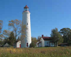
| Point Clark (ON 76)
latitude 44° 4' 22.2" N longitude 81° 45' 26.3" W
October 11, 2003 access: car
This 80 foot tall tower; made of local limestone is really impressive. It's also in the middle of a very pleasant looking community. Being beach frontage houses; they probably aren't cheap; but they don't look intentionally extravagant either.
This photo is featured on the Canadian Stamps about lighthouses. ARLHS # CAN-388 |
| 70 |
Goderich (ON 77)
October 13, 2003 access: car
This, the very last light on Lake Huron, doesn't look very impressive. The tower is only 35 feet tall; but it's at the top of a 100 (or more) foot cliff right next to the river, so it's visible from a very long way out in the lake.
There's a salt loading station just below here, and they bring the full size Lake carriers in, so it's probably important they know where the river mouth is. ARLHS # CAN-546 |
|
|
|
If you would like copies of any of my pictures; contact me and we'll discuss arrangements. There are others who do this commercially; I have no intention of competing directly; but you can make a proposal; and I'll react. mailMe

 Lake Michigan
 Lake Superior