|
This page currently shows my understanding of Lighthouses of Labrador and also Newfoundland. Copies of these pictures are stored on the web if you want to download them. Click on [most] any photo and that will take you to that photo. I would like to include directions on how to get to these lights. If you know such data, could you eMail me and I'll post it here (with your choice of attribution.) mailMe Orange italicized numbers in parentheses are references to the Canadian Coast Guard List of Lights (Newfoundland and Labrador). |
|
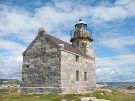
| NL 1 |
Camp Islands |
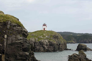
Sibling of Cape Bauld. This is the northernmost lighthouse on the Atlantic coast of the Americas. Located on a small island near Battle Harbour. Accessible only by boat or helicopter. NL11 (H 0094) [279] ARLHS # CAN-678 |
| NL 2 |
Double Island |
Sibling of Long Island East End. Located at the highest point of the island, on the approaches to Battle Harbour. Accessible only by boat or helicopter. NL16 (H 0092) [278] ARLHS # CAN-681 |
| NL 3 |
Belle Isle Northeast
Located at the northeastern end of the island, which lies halfway between the northern peninsula of Newfoundland and the Labrador mainland. Accessible only by boat (in heavy seas) or helicopter. (H 0096) [232] ARLHS # CAN-648
Photo courtesy G. T. Hart [panoramio] |
|
| NL 4 |
Belle Isle South End Upper |
A historic lighthouse, one of four "Imperial towers" built on the northern approaches to the St. Lawrence in the 1850s. Its construction was a significant engineering accomplishment for its time. Located on top of the main ridge of the island at the southwest end. Accessible only by boat (in heavy seas) or helicopter. (H 0102) [233] ARLHS # CAN-675 |
| NL 5 |
Belle Isle South End Lower |
Located atop the bluff at the extreme southwest tip of the island. Accessible only by boat (in heavy seas) or helicopter. (H 0104) [234] ARLHS # CAN-747 |
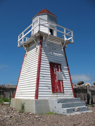
| NL 6 |
Saddle Island (Red Bay) |
Red Bay is the site of a 16th century Basque whaling camp, and the island is the site of a whalers' cemetery. Located on an island in the entrance to Red Bay, visible from the town of Red Bay, which is at the extreme end of the paved road NF 510 about 80 km northeast of L'Anse Amour. Accessible by boat, passenger ferry service from the town of Red Bay is available. (H 0110) [230] ARLHS # CAN-750 |
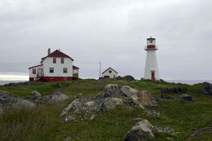
| NL 7 |
St. Modeste Island
Located on a small island about 90 meters off the north coast of the Strait of Belle Isle. Accessible only by boat, but easily visible from land near the village of St. Modeste. (H 0111) [229] ARLHS # CAN-700
Photo courtesy Robert Smith [RS photography] |
|
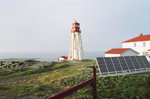
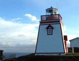
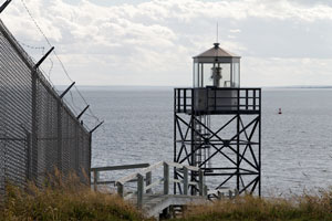
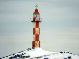
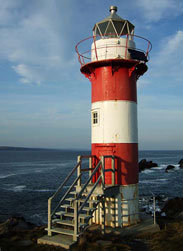
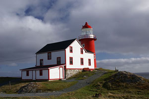
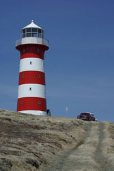
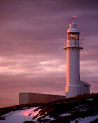
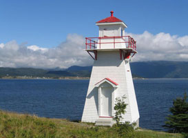
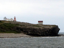
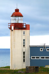
| NL 8 |
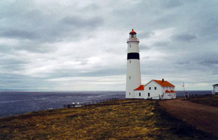
| PointAmour
Drive to North Sydney, Nova Scotia from where Marine Atlantic's ferry service will take you to Port aux Basques, Newfoundland. You can drive up the west coast of Newfoundland and get a ferry to Blanc Sablon, Quebec -- call 800-563-6353 for information and reservations. The Trans-Labrador highway leads to Goose Bay, where you can take a Marine Atlantic coastal ferry to the Labrador Straits region. Alternately, you can drive to North Sydney, Nova Scotia from where Marine Atlantic's ferry service will take you to Port aux Basques, Newfoundland. (H 0114) [227] ARLHS # CAN-665
Photo courtesy senecal [webshots] |
Newfoundland Atlantic Coast
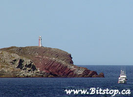
| NL 10 |
Cape Norman
Located near the tip of the Great Northern Peninsula. Accessible by gravel road from Cooks Harbour. (H 0140) [223] ARLHS # CAN-679
Photo courtesy hanakh1 [webshots] |
|
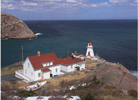
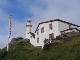
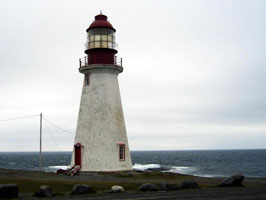
| NL 11 |
| Cape Bauld
latitude 51° 38' 26.3" N longitude 55° 25' 38.9" W
The two buildings are now used as an inn (transportation to the site provided). Located at the northern tip of Quirpon Island, marking the northernmost point of Newfoundland. Accessible only by boat or helicopter. (H 0132) [225] ARLHS # CAN-652
Photo courtesy Copyright Dan Drost [pbase] |
| NL 12 |
Fox Point (Fishing Point)
latitude 51° 21' 22.2" N longitude 55° 33' 18.4" W
Located at the south entrance to the harbor of St. Anthony. Accessible by car and by a hiking trail from town.
Take Route 430 to St. Anthonys, near the northern end of the Great Northern Peninsula, and then turn east onto West Street. Follow West Street, which will turn into Fishing Point, to its end at the Fox Point Lighthouse. (H 730) [240] ARLHS # CAN-684
Photo courtesy hanakh1 [webshots] |
|
| NL 13 |
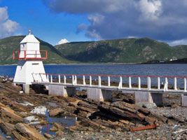
| Conche
A boardwalk provides access to the tower. Located just offshore on Silver Point at the entrance to Conche Harbour. Conche is accessible by a gravel road off NF 433. (H 0722) [247] ARLHS # CAN-749
Photo courtesy hanakh1 [webshots] |
| NL 14 |
Westport Cove |
Located on the north side of the harbor, on the east side of White Bay, accessible by a hiking trail from the town of Westport Cove. There is a picnic park by the lighthouse. (H 0704) [260] ARLHS # CAN-702 |
| NL 15 |
Gull Island Cape John
latitude 49° 59' 49.4" N longitude 55° 21' 53.9" W |
Located at the top of a high, barren island off the eastern tip of the Baie Verte Peninsula. Accessible only by helicopter or by boat in heavy seas. (H 0686) [326] ARLHS # CAN-660 |
| NL 16 |
Long Island East End |
Located on the eastern end of Long Island, on the south side of Notre Dame Bay. The island is accessible by car ferry from Pilley's Island. schedule (H 0675) [340] ARLHS # CAN-682 |
| NL 17 |
Surgeon Cove Point
latitude 49° 31' 7.8" N longitude 55° 7' 2.5" W |
Located on an island in the Bay of Exploits, on the southwest side of Notre Dame Bay. Accessible only by boat. (H 0656) [347] ARLHS # CAN-490 |
| NL 18 |
Long Point
The island has a spectacular site: located at Devil's Cove Head on North Twillingate Island, with a sweeping view of Notre Dame Bay and its rocky islands. The island is linked to the mainland by a causeway. (H 0640) [358] ARLHS # CAN-285
Photo courtesy RP Jenkins [webshots] |
|
| NL 19 |
Bacalhao Island
latitude 49° 41' 13" N longitude 54° 33' 24.4" W |
Located at the southwest end of the island, about 25 km east of Twillingate. Accessible only by boat. (H 0635) [363] ARLHS # CAN-647 |
| NL 19C |
Change Islands |
The original lighthouse, a square pyramidal wood tower, has been demolished. Located at the southwestern tip of South Change Island. The island is accessible by ferry from Farewell ferry (H 626) ARLHS # CAN-836 |
| NL 20 |
Burnt Point
latitude 49° 36' 3.6" N longitude 54° 9' 29.3" W
The island is accessible by ferry from Farewell. ferry
Located on a point of land marking the east side of the entrance to Seldom Harbour, on the south side of Fogo Island. (H 0612) [378] ARLHS # CAN-677
Photo courtesy Lee Shelp [Flickr] |
|
| NL 20P |
North Penguin Island
latitude 49° 26' 57.4" N longitude 53° 48' 36.5" W |
The two Penguin Islands lie to the south of the Wadham Islands. Located on the eastern tip of the island. Accessible only by boat. (H 0588) ARLHS # CAN-697 |
| NL 21 |
Peckford Island
latitude 49° 31' 49.8" N longitude 53° 51' 5" W |
Located on the largest of the Wadham Islands about 6.5 km south of Offer Wadham Island. Accessible only by boat. (H 0586) [395] ARLHS # CAN-697 |
| NL 22 |
Offer Wadham Island |
Located on a small island between Fogo Island and Musgrave Harbour, in the entrance to Hamilton Sound. Accessible only by boat. (H 0584) [396 ] ARLHS # CAN-696 |
| NL 23 |
Cabot Islands |
Located on a small island 6 miles southeast of Cape Freels in the northern entrance to Bonavista Bay. Accessible only by helicopter or by boat in heavy seas. (H 0576) [406] ARLHS # CAN-068 |
| NL 24 |
Puffin Island |
Located on an island about ¼ mi off Greenspond on the northwest side of Bonavista Bay. Accessible only by boat.
Light is visible from Greenspond photo (H 0556) [430] ARLHS # CAN-418 |
| NL 25 |
Little Denier Island
latitude 48° 41' 9.1" N longitude 53° 35' 23.2" W |
Located on a high island east of Salvage, off the tip of the Eastport Peninsula. Essentially inaccessible, landing on the steep-sided island is extremely difficult. (H 0543) [441] ARLHS # CAN-663 |
|
|
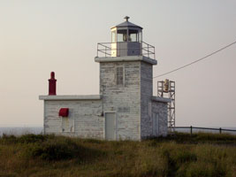
| NL 26 |
Kings Cove Head
Located on a headland near the town of King's Cove, the town, on NF 235 southwest of Bonavista, holds a lighthouse festival the first weekend of August. Accessible by a hiking trail from town. trail (H 0540) [443] ARLHS # CAN-662
Photo courtesy John King [wikimedia] |
|
| NL 27 |
| Cape Bonavista
latitude 48° 42' 5.8" N longitude 53° 5' 7.4" W
Located on the point of the cape, about 7 km north of Bonavista. Accessible by road. Both the 1843 light and the 1966 are at this location. (H 0536) [449] ARLHS # CAN-093
Photo courtesy Copyright Dan Drost [pbase] |
| NL 28 |
Green Island (Catalina)
latitude 48° 30' 14.8" N longitude 53° 2' 36.4" W |
Note there is another Green Island Light on the south coast. Located on an island at the southern entrance to Catalina Harbour. Accessible only by boat. NL57 (H 0526) [453] ARLHS # CAN-687 |
| NL 29 |
Manuel Island
latitude 48° 30' 40.2" N longitude 53° 4' 3.1" W
Located ¼ mile off Courage's Point in Catalina Harbour, south of Bonavista. Accessible only by boat. (H 0528) [458] ARLHS # CAN-693
Photo courtesy Karen Chappell [bitstop] |
|
| NL 30 |
| Fort Point (Admiral's Point)
latitude 48° 21' 56.1" N longitude 53° 20' 45.5" W
Sibling of the Fox Point Light. Located on a promontory on the south side of the entrance to Trinity Harbour. NL12 (H 0520) [462] ARLHS # CAN-746
Photo courtesy Copyright Dan Drost [pbase] |
| NL 31 |
Random Head Harbour
latitude 48° 5' 41.5" N longitude 53° 32' 43.5" W
Located at East Random Head on Motion Island in Trinity Bay east of Hickman's Harbour. Visible distantly from the cliff tops at Random Head. (H 0514) [465] ARLHS # CAN-667
Photo courtesy tclenche [webshots] |
|
| NL 32 |
| Heart's Content
latitude 47° 52' 56.2" N longitude 53° 23' 6.5" W
Located at the northern entrance to the harbor of Heart's Content, on the east side of Trinity Bay. Accessible by a short walk from town. (H 0510) [468] ARLHS # CAN-543
Photo courtesy Jean Knowles [Flickr] |
| NL 33 |
Hant's Harbour
latitude 48° 1' 18.5" N longitude 53° 15' 16.7" W
Located at the entrance to Hant's Harbour, on the east side of Trinity Bay. Accessible by a short walk from town. There is a picnic area adjacent to the lighthouse.
(H 0504) [470] ARLHS # CAN-688
Photo courtesy litehouseman [Flickr] |
|
| NL 34 |
Baccalieu Island |
Located at the north end of Baccalieu Island off the tip of the Bay de Verde Peninsula. Accessible only by helicopter or boat in heavy seas. The modern light is a simply triangular steel tower. (H 0498) [472] ARLHS # CAN-671 |
| NL 35 |
Baccalieu Island Southwest Point
latitude 48° 6' 25.7" N longitude 52° 48' 39.1" W |
Located at the southwest end of the island in a Ecological Reserve. (H 0500) [473] ARLHS # CAN-672 |
| NL 36 |
Green Point (Bay Roberts)
latitude 47° 36' 41.8" N longitude 53° 10' 36.1" W
Located on a headland on the east side of Bay Roberts, on Conception Bay. Accessible by a rough road (4WD recommended) leading 2.5 km from Hibb's Cove. (H 0482) [486] ARLHS # CAN-659
Photo courtesy Clyde Barrett [Flickr] |
|
| NL 37 |
| Brigus (North Head)
latitude 47° 32' 54.6" N longitude 53° 10' 55.3" W
Located on North Head, at the entrance to Brigus Harbour on Conception Bay. Accessible on foot, but it is a rough 6 km from town. (H 0478) [488] ARLHS # CAN-832
Photo courtesy Karen Chappell [bitstop] |
| NL 38 |
Bell Island
latitude 47° 39' 18.1" N longitude 52° 54' 59.3" W
Located at the northeast tip of Bell Island in Conception Bay. Accessible by a short gravel road. BellIsland (493H 0470) [493] ARLHS # CAN-673
Photo courtesy Doug Mercer [Flickr] |
|
| NL 39 |
| Cape St. Francis
latitude 47° 48' 31.4" N longitude 52° 47' 11.7" W
Located on the cape marking the southern entrance to Conception Bay. Accessible by a rough road from Pouch Cove. (H 0468) [499] ARLHS # CAN-835
Photo courtesy Laura Grover [Flickr] |
| NL 40 |
Fort Amherst
latitude 47° 33' 47.9" N longitude 52° 40' 49.6" W
This is Newfoundland's oldest active light station. Located on the south side of the entrance to the harbor of St. John's, Newfoundland's capital city, accessible by car.
(cropped to fit this format) (H 0458) [506] ARLHS # CAN-683
Photo courtesy Mark Veitch [Flickr.] |
|
| NL 41 |
| Cape Spear 1836
latitude 47° 31' 11.8" N longitude 52° 37' 24" W
This is Newfoundland's oldest lighthouse and second oldest light station, the lighthouse has been restored to its 1839 appearance. Located southeast of St. John's at the end of NF 11 (Cape Spear Drive). ARLHS # CAN-748
Photo courtesy JohnW [Flickr] |
| NL 42 |
Cape Spear 1955
latitude 47° 31' 16.2" N longitude 52° 37' 20.3" W
This is the easternmost lighthouse in North America, standing in longitude 52° 7.3' W. (H 0454) [507] ARLHS # CAN-148
Photo courtesy Jean Knowles [Flickr] |
|
| NL 43 |
| Bay Bulls (Bull Head)
latitude 47° 18' 38.7" N longitude 52° 44' 48.6" W
Located on the north side of the entrance to Bay Bulls Harbour. Accessible by a 5 km trail from Bay Bulls, which is on NF 10 south of St. John's. (H 0452) [508] ARLHS # CAN-650
Photo courtesy Rexton [Flickr] |
| NL 44 |
Ferryland Head
latitude 47° 1' 1.1" N longitude 52° 51' 27.3" W
Located on a headland on the south side of the harbor of Ferryland. Town accessible via NF 10 from St. John's, light station accessible at the end of a 2.5 km trail. (H 0450) [509] ARLHS # CAN-656
Photo courtesy Jean Knowles [Flickr] |
|
| NL 45 |
| Bear Cove Point
Located on a headland about 10 km south of Ferryland and 7 km southeast of Fermeuse. Accessible by a gravel road from Renews, southeast of Fermeuse. (H 0448) [512] ARLHS # CAN-1326
Photo courtesy Karen Chappell [bitstop] |
Southeast Coast
| NL 46 |
Cape Race
latitude 46° 39' 30.9" N longitude 53° 4' 25" W
Located on the southeasternmost point of Newfoundland, accessible by a 20 km gravel road (4WD strongly recommended). (H 0444) [1] ARLHS # CAN-118
Photo courtesy bigsister [webshots] |
|
| NL 47 |
| Powles Head
latitude 46° 41' 25.2" N longitude 53° 24' 5.7" W
Located on a headland at the eastern entrance to the harbor of Trepassy, west of Cape Race. Accessible by 5 km gravel road (walking or 4WD recommended). (H 0442) [5] ARLHS # CAN-698
Photo courtesy Karen Chappell [bitstop] |
| NL 48 |
Cape Pine
latitude 46° 37' 1.4" N longitude 53° 31' 54" W
Located at the western entrance to the harbor of Trepassy. Accessible by an 8 km gravel road (walking or 4WD commended). (H 0440) [6] ARLHS # CAN-653
Photo courtesy Jean Knowles [Flickr] |
|
| NL 49 |
| La Haye Point
latitude 46° 54' 15" N longitude 53° 36' 56.3" W
Located on a point marking the south side of the entrance to St. Mary's Harbour, about 2.5 km west of the town of St. Mary's. (H 0436) [8]
Photo courtesy Karen Chappell [bitstop] |
|
|
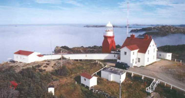
| NL 50 |
Cape St. Mary's
latitude 46° 49' 23.6" N longitude 54° 11' 41.8" W
Located at the extreme point of the cape, south of St. Bride's. Accessible by a single-lane paved road 13 km long. (H 0432) [14] ARLHS # CAN-721
Photo courtesy Jeff Milsteen [Flickr] |
|
| NL 51 |
| Point Verde
latitude 47° 14' 15.1" N longitude 54° 55.1" W
Located on the point at the southern entrance to Placentia Roads from Placentia Bay, about 3 km west of the city of Placentia. (H 0422) [16] ARLHS # CAN-807
Photo courtesy ianturton [Flickr] |
| NL 52 |
Marticot Island
latitude 47° 19' 37.4" N longitude 54° 34' 53.1" W |
Located on an island off the west shore of Placentia Bay about 4 km southwest of Little Paradise. Accessible only by boat. (H 0386) [50] ARLHS # CAN-694 |
| NL 53 |
Long Island
latitude 47° 17' 53.1" N longitude 54° 42' 17.3" W |
Located on the south end of the island, on the west side of Placentia Bay. Accessible only by boat. (H 0380) [52] ARLHS # CAN-692 |
| NL 54 |
Tides Cove Point
latitude 47° 8' 34" N longitude 55° 4' 43.4" W |
Located 2.5 km northeast of Fox Cove on the east side of the Burin Peninsula. (photo) (H 0372) [65] ARLHS # CAN-1341 |
| NL 55 |
Little Burin Island
latitude 46° 58' 51" N longitude 55° 11' 26.9" W |
Located on the east side of the island, near the entrance to Burin Harbour. Accessible only by boat. (H 0364) [71] ARLHS # CAN-691 |
| NL 56 |
Middle Head
latitude 46° 53' 52.9" N longitude 55° 20' 52.6" W |
Located on a promontory about 8 km southeast of St. Lawrence (H 0360) [73] |
| NL 57 |
Green Island
latitude 46° 52' 48.1" N longitude 56° 5' 7.2" W |
This is a staffed Coast Guard station. Located at the summit of the island in Fortune Bay, off the Burin Peninsula. Accessible only by boat. (H 0348) [100] ARLHS # CAN-658 |
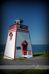
| NL 58 |
Fortune Head
latitude 47° 4' 27.8" N longitude 55° 51' 33.5" W
This is a staffed station which also serves as the visitor center for the Fortune Head Ecological Reserve. Trails exploring the reserve begin at the light station parking lot. Located on a promontory about 1.6 km west of Fortune. reserve (H 0325) [102] ARLHS # CAN-1284
Photo courtesy TinaB Photography [Flickr] |
|
| NL 59 |
| Grand Bank
latitude 47° 6' 4.8" N longitude 55° 44' 58.2" W
Located at the end of the east breakwater in Grand Bank, a town on the west side of the Burin Peninsula. There are good views from the waterfront. (H 0322) [106] ARLHS # CAN-686
Photo courtesy Marc George [Flickr] |
| NL 60 |
Garnish
latitude 47° 14' 10.5" N longitude 55° 21' 30.3" W
Located on the southern breakwater at Garnish, a town on the northwestern shore of the Burin Peninsula. (H 0318) [112] ARLHS # CAN-685
Photo courtesy Geoff Smith [panoramio] |
|
| NL 61 |
Belleoram |
Located on Beach Point, a curving spit that protects the harbor of Belleoram, an isolated town on the west side of Fortune Bay. [117] |
| NL 62 |
St. Jacques Island
latitude 47° 28' 25.3" N longitude 55° 24' 22.7" W |
Located on a small island in Fortune Bay near Belleoram. Accessible only by boat. (H 0304) [118] ARLHS # CAN-669 |
| NL 63 |
English Harbour West |
Located on a promontory on the east side of entrance to English Harbour West, a town on the Connaigre Peninsula on the northwest side of Fortune Bay. (photo) (H 0302) [119] |
| NL 64 |
Rocky Point
latitude 47° 28' 46.6" N longitude 55° 47' 34.8" W |
Located on the south side of the entrance to Harbour Breton. (H 0294) [124] ARLHS # CAN-699 |
| NL 65 |
Dawson's Point |
Located on a headland on Hermitage Bay near Pushthrough. (H 0276) [134] ARLHS # CAN-838 |
| NL 66 |
Salmon Point (Taylor Island)
latitude 47° 37' 3" N longitude 56° 12' 1.7" W |
Taylor Island is a small island on the north side of the entrance to Hermitage Bay. Accessible only by boat. (H 0275) [135] |
| NL 67 |
François Bay
latitude 47° 33' 36.3" N longitude 56° 44' 1.5" W |
Located on a promontory on the west side of the entrance to François Bay. Accessible only by boat. photo (H 0270) [137] ARLHS # CAN-701 |
| NL 68 |
Northwest Head (Ramea)
latitude 47° 30' 45" N longitude 57° 24' 31.5" W
Located on an island about 6 km off the coast near the western entrance to Hermitage Bay. Accessible by road or hiking trail from the town of Ramea, which is reached by car ferry from Burgeo. ferry (H 0264) [141] ARLHS # CAN-695
Photo courtesy Anthony Rose [Flickr] |
|
| NL 69 |
| Rose Blanche
latitude 47° 36' 6.1" N longitude 58° 41' 40.6" W
Located off NF 470 about 25 miles east of Channel-Port aux Basques. (H 0242.5) [150.19] ARLHS # CAN-668
Photo courtesy hanakh1 [webshots] |
| NL 70 |
Colombier Islands |
Located on an island off Burnt Island, midway between Rose Blanche and Channel-Port aux Basques. Accessible only by boat. (H 0238) [156] ARLHS # CAN-837 |
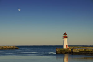
| NL 71 |
Channel Head (Channel-Port-aux-Basques)
latitude 47° 33' 57.3" N longitude 59° 7' 24.8" W
Located on an island in Channel-Port aux Basques harbor. Accessible only by boat, but visible from the Gulf of St. Lawrence ferry steamers as they enter or leave the harbor. (H 0222) [160] ARLHS # CAN-654
Photo courtesy Robert Hall / Steady Brook [Flickr] |
|
West Coast
| NL 72 |
| Cape Ray
latitude 47° 37' 16.3" N longitude 59° 18' 14.2" W
Located at the southwestern tip of Newfoundland about 15 km west of Channel-Port aux Basques. (H 0220) [173] ARLHS # CAN-645
Photo courtesy hanakh1 [webshots] |
| NL 73 |
Cape Anguille
latitude 47° 54' 2.5" N longitude 59° 24' 40" W
Located at the end of NF 407, northwest of Cape Ray near Codroy. (H 0218) [175] ARLHS # CAN-651
Photo courtesy hanakh1 [webshots] |
|
| NL 74 |
Harbour Point (Sandy Point)
latitude 48° 27' 26.1" N longitude 58° 29' 19.7" W |
Located on Sandy Island at the entrance to St. George's Harbour. Accessible only by boat; tours of the historic island are available. photo (H 0208) [178] ARLHS # CAN-690 |
| NL 75 |
Broad Cove Point Range Front Relocated to Fox Island River |
Located on a bluff at Broad Cove Point marking the entrance to Port au Port Harbour. Accessible only by boat. The new location is private property, but the light is visible from the road. (H 0199) [188] ARLHS # CAN-833 |
| NL 76 |
Broad Cove Point Range Rear |
Located about 340 m southeast of the front range tower. Accessible only by boat. May no longer be present. (H 0199.1) [187] ARLHS # CAN-834 |
| NL 77 |
South Head |
Located at the southern entrance to the Bay of Islands, about 3.5 mi north of Lark Harbour. Site open but quite difficult to reach by land. (H 0192) [192] ARLHS # CAN-751 |
| NL 78 |
Woody Point
latitude 49° 30' 17.3" N longitude 57° 54' 45.1" W
Located at the entrance to the south arm of Bonne Bay near the community of Woody Point, an enclave in Gros Morne National Park park (H 0168) [200] ARLHS # CAN-703
Photo courtesy hanakh1 [webshots] |
|
| NL 79 |
| Lobster Cove Head
latitude 49° 36' 10.1" N longitude 57° 57' 21.8" W
Located between Rocky Harbour and Lobster Cove. (H 0164) [201] ARLHS # CAN-646
Photo courtesy hanakh1 [webshots] |
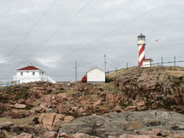
| NL 80 |
Cow Head
Located on a headland near the town of Cow Head; a marked hiking trail leads to the lighthouse. ARLHS # CAN-680
Photo courtesy hanakh1 [webshots] |
|
| NL 80N |
| Cow Head (2003)
Photo courtesy hanakh1 [webshots] |
| NL 81 |
Keppel Island
latitude 50° 37' 59.2" N longitude 57° 19' 19.7" W
Located atop a bluff on an island off Port Saunders, a few miles south of Port au Choix. Accessible only by boat.
There are actually 2 lights here, the 1901 light and the 1992 light. (H 0156) [208] ARLHS # CAN-661
Photo courtesy hanakh1 [webshots] |
|
| NL 82 |
| Pointe Riche (Port au Choix)
latitude 51° 1' 21.3" N longitude 57° 5' 44.5" W
Located at Port au Choix, north of Corner Brook on NF 430. Accessible by a dirt road or by hiking the Phillip's Garden Coastal Trail. (H 0154) [211] ARLHS # CAN-666
Photo courtesy hanakh1 [webshots] |
| NL 83 |
Flowers Cove
latitude 51° 18' 30.2" N longitude 56° 44' 54.6" W
Located on an island in the mouth of Flower's Cove. Accessible only by boat. (H 0144) [213] ARLHS # CAN-657
Photo courtesy hanakh1 [webshots] |
|
| NL 84 |
| Férolle Point
Located at Férolle Point. (H 0148) [220] ARLHS # CAN-655
Photo courtesy hanakh1 [webshots] |
St. Pierre and Miquelon
| NL 85 |
Galantry (Tête de Galantry)
latitude 46° 45' 54.2" N longitude 56° 9' 13.7" W
Located on the southeastern shore of Île Saint-Pierre. The station is accessible by road from the town of Saint-Pierre. (H 0332) ARLHS # SPM-008
Photo courtesy Gerd McKenna [Flickr] |
|
| NL 86 |
Rocher Petit Saint-Pierre
latitude 46° 46' 37.9" N longitude 56° 9' 20.1" W |
The tower formerly carried a conventional lantern room. Located on a tiny waveswept rock off the entrance to the harbor of Saint-Pierre. Accessible only by boat. (H 0338) ARLHS # SPM-007 |
| NL 86N |
Rocher Petit St. Pierre North Pier Head
latitude 46° 47' 10.6" N longitude 56° 9' 47.3" W |
ARLHS # SPM-004 |
| NL 86S |
Rocher Petit St. Pierre South Pier Head
latitude 46° 46' 43.5" N longitude 56° 10' 5.7" W |
ARLHS # SPM-006 |
| NL 87 |
Île aux Marins (Île aux Chiens)
latitude 46° 46' 54" N longitude 56° 9' 16.3" W |
Inhabited until the 1950s, the island is now a historic site. Its name was changed from Île aux Chiens (Dog Island) to Île aux Marins (Sailors Island) in 1931. Located at the southwestern tip of the island, which shelters the harbor of Saint-Pierre. Tours of the island are available in season. view ARLHS # SPM-009 |
| NL 88 |
Pointe aux Canons (Saint-Pierre)
latitude 46° 46' 53" N longitude 56° 9' 58.1" W
The lighthouse was the front light of a range from 1887 to the 1960s, but the rear lighthouse has been demolished. Since the light is now inside the outer breakwaters, its navigational value is somewhat questionable. Located at the end of a stone pier in the harbor at Saint-Pierre. ARLHS # SPM-010
Photo courtesy Robert Smith [RS Photography] |
|
| NL 89 |
Pointe Plate (Île Langlade)
latitude 46° 49' 20.3" N longitude 56° 24' 8.5" W |
Located at the southwestern tip of Île Langlade, which is connected to Miquelon by a narrow, sandy isthmus. photo ARLHS # SPM-001 |
| NL 90 |
Cap Blanc (Miquelon)
latitude 47° 6' 17.5" N longitude 56° 23' 56.3" W |
Located on a headland on the northwestern tip of Miquelon. Accessible by road from the town of Miquelon. closeup ARLHS # SPM-002 |
| NL 91 |
Miquelon Wharf
latitude 47° 6' 10" N longitude 56° 22' 31.4" W |
ARLHS # SPM-003 |
|
|


