|
This page shows the documentation of the Lighthouses of Atlantic facing France. Most of the photos below are set so you can click on the photo of the light to go to it's specific (larger resolution) copy. Each lighthouse name is linked to (in our editorial opinion) the best reference site for that light. I would like to include directions on how to get to these lights. If you know such data, could you eMail me and I'll post it here (with your choice of attribution.) There has been significant improvements in content by comparing my other data with the Lighthouse Directory prepared by Russ Rowlett (UNC). My thanks to him for providing this basis for understanding. lhDirectory |
|
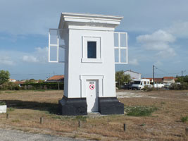
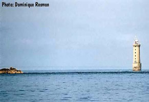
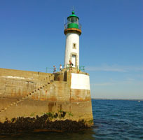
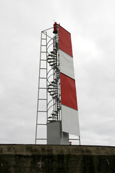
FR 168
[FR89E] |
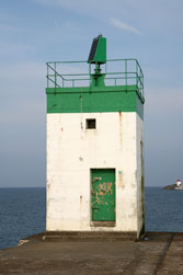
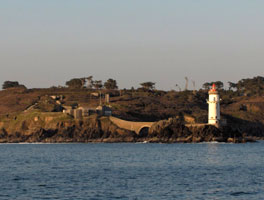
Pointe de Corsen
latitude 48° 24' 52.9" N longitude 4° 47' 37" W
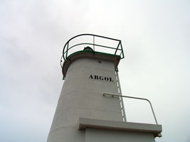
Located on the point, about 1 km southwest of the Trézien lighthouse. As you can see, the house is in ruins. It looks like the actual light was through the break in the wall on the left. (A 1876) ARLHS # FRA-061
Photo courtesy Dominique Resmon [Carceller] |
|
FR 165
[FR89A] |
| Aber Ildut
latitude 48° 28' 16" N longitude 4° 45' 33.8" W
Located on the north side of the Aber Ilbut entrance in Lanildut. (A 1856) ARLHS # FRA-113
Photo courtesy John Cristophe Fichou [PharesFrance] |
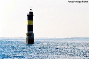
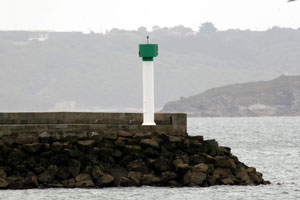
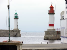
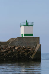
FR 166
[FR89B] |
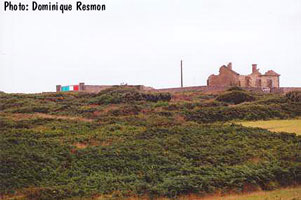
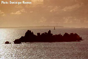
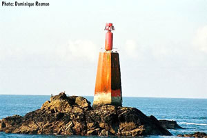
Les Plâtresses
This light was located on a wave swept rock about 6 km offshore from Trézien. Accessible only by boat, there is a distant view from shore. It has been swept away and now is only a post. In this photo you can see Les Plâtresses in the "foreground" and Le Stiff behind it. ARLHS # FRA-400
Photo courtesy Dominique Resmon [Carceller] |
|
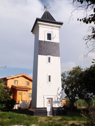
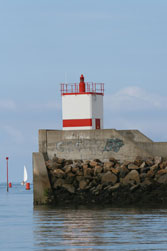
FR 167
[FR89D] |
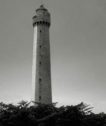
| Trézien (feu postérieur)
latitude 48° 25' 24.6" N longitude 4° 46' 43.9" W
Located about 500 m west of the Pointe de Trézien in the town of Trézien. (A 1873.9) ARLHS # FRA-750
Photo courtesy Ellen [Flickr] |
FR 169
[FR89C] |
[Le] Faix
Located on a reef about 7 km west of the coast at Trézien. Accessible only by boat. (A 1862) ARLHS # FRA-279
Photo courtesy John Cristophe Fichou [PharesFrance] |
![[Le] Faix](CE/FranceW/faix.jpg)
|
FR 170
[FR89F] |
| Les Trois Pierres (Île Molène)
Some of the Île d'Ouessant ferries also stop at Île Molène. ferry
Located on a rock on the northeast side of the island, at the entrance to the harbor. Accessible only by boat, but there is a good view from the ferries. (D 0974) ARLHS # FRA-526
Photo courtesy Dominique Resmon [Carceller] |
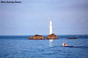
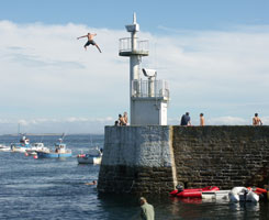
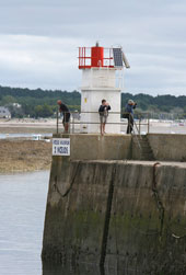
FR 171
[FR89G] |
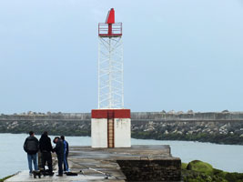
Île Molène Pier
latitude 48° 24' 9.6" N longitude 4° 57' 23.5" W
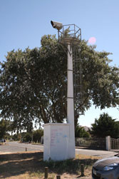
Looks like this light is more valuable as a diving board than as a navigation aid. (A 1871)
Photo courtesy Pierre-Arnaud Gillet [Flickr] |
|
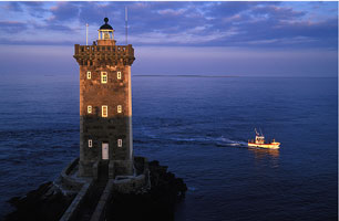
FR 172
[FR92] |
| Kéréon
Located on the usually-submerged Men-Tensel reef about 2 km southeast of the eastern point of the Île d'Ouessant. Accessible only by boat, there is a distant view from the Île d'Ouessant. (A 1850) ARLHS # FRA-324
Photo courtesy Doninque Resmon [Phares] |
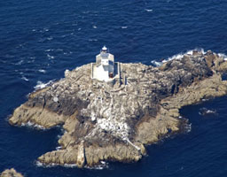
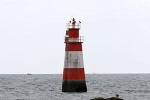
FR 173
[FR92A] |
Men-Korn
latitude 48° 26' 15.1" N longitude 5° 1' 32.9" W
Located about 1 km east of the easternmost point of the Île d'Ouessant. Accessible only by boat, there is a distant view from the Île d'Ouessant. (A 1852) ARLHS # FRA-355
Photo courtesy Dominique Resmon [Carceller] |
|
FR 174
[FR90] |
![[Le] Stiff](CE/FranceW/Stiff.jpg)
| [Le] Stiff
latitude 48° 28' 28.2" N longitude 5° 3' 24.4" W
Located atop a bluff at the northern end of the Île d'Ouessant. (A 1842) ARLHS # FRA-036
Photo courtesy Camille Leroux [Flickr] |
FR 175
[FR91] |
Creac'h
latitude 48° 27' 32.9" N longitude 5° 7' 44.3" W
Located at the northwestern tip of the Île d'Ouessant. (A 1844) ARLHS # FRA-029
Photo courtesy Mr Fenwick [Flickr] |
|
FR 176
[FR93] |
| Nividic
latitude 48° 26' 45.2" N longitude 5° 9' 3.7" W
Located 900 m west of the westernmost point of the Île d'Ouessant. Accessible only by boat in some of the most dangerous seas anywhere. (A 1846) ARLHS # FRA-044
Photo courtesy S. Besnard [Flickr] |
FR 177
[FR97] |
La Jument
Located about 2.2 km southwest of the southern tip of the Île d'Ouessant. Accessible only by boat. (A 1898) ARLHS # FRA-026
Photo courtesy sbesnard [Flickr] |
|
FR 178
[FR97A] |
| La Grande Vinotière
Located about 1.5 km west of the Pointe de Kermorvan, on the north side of the entrance to Le Conquet and at the south end of the Chenal du Four. Accessible only by boat; there is a distant view from the Kermorvan lighthouse. In this photo, Vinotiere is in the foreground, Molène is in the background. (A 1872) ARLHS # FRA-306
Photo courtesy Dominique Resmon [Carceller] |
FR 179
[FR97B] |
Kermorvan (feu antérieur)
latitude 48° 21' 43.9" N longitude 4° 47' 24.1" W
Located at the extreme tip of the Pointe de Kermorvan, which protects the north side of the harbor of Le Conquet. Excellent view from the ferries to the Île d'Ouessant. ARLHS # FRA-024
Photo courtesy Laurent Bénard [Flickr] |
|
FR 180
[FR97C] |
| Lochrist (feu postérieur)
latitude 48° 20' 33" N longitude 4° 45' 48.3" W
Located on a hilltop just south of Le Conquet, about 2.7 km southeast of the Kermorvan light, which serves as the front light of the range. (A 1880) ARLHS # FRA-339
Photo courtesy Dominique Resmon [Carceller] |
FR 181
[FR94] |
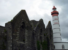
Saint Mathieu
latitude 48° 19' 47.9" N longitude 4° 46' 15.1" W
Located on the Pointe St.-Mathieu about 3 km south of Le Conquet, marking the beginning of the approach to Brest, on a clear day more than a dozen lighthouses can be seen from this location. (A 1875) ARLHS # FRA-056
Photo courtesy pietroizzo [Flickr] |
|
FR 182
[FR94A] |
| Feu des Vieux Moines
latitude 48° 19' 19.9" N longitude 4° 46' 37.4" W
Located just off Pointe St.-Mathieu. Accessible only by boat, but easily seen from shore. (A 1884) ARLHS # FRA-533
Photo courtesy Dominique Resmon [Carceller] |
FR 183
[FR94B] |
[Les] Pierres Noires
Located on a rocky islet about 9 km west of Pointe St.-Mathieu and 8 km southeast of Île Molène. Accessible only by boat, only a very distant view from shore, but there is a closer view from the ferries to the Île d'Ouessant. (A 1886) ARLHS # FRA-050
Photo courtesy Claude Carnot [Flickr] |
![[Les] Pierres Noires](CE/FranceW/PierresNoires.jpg)
|
FR 184
[FR95] |
| Pointe du Petit Minou
latitude 48° 20' 11.9" N longitude 4° 36' 51.3" W
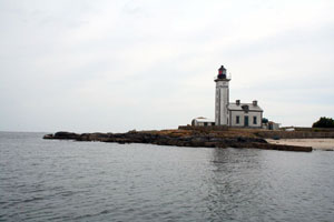
front range for the light below. Located on an islet just offshore, connected to the mainland by an arched stone bridge, at the northern entrance to the Goulet (narrows) de Brest, about 6 km southwest of La Trinité. Site and tower closed (the location is part of a naval base), the best views are from the ferries from Brest to the Île d'Ouessant. This photo is cropped to fit this space. Take a look at her photo on Flickr if you want to see a really beautiful photo. (D 0790) ARLHS # FRA-032
Photo courtesy Ellen [Flickr] |
FR 185
[FR95R] |
La Roche Mengant
latitude 48° 20' 19.7" N longitude 4° 34' 34.1" W
Located on an isolated rock in the middle of Goulet de Brest. ARLHS # FRA-032
Photo courtesy Dominique Resmon [Carceller] |
|
FR 186
[FR96] |
| Portzic
latitude 48° 21' 29.9" N longitude 4° 32' 3.2" W
rear range for Pointe du Petit Minou (see above) (D 0790.1) ARLHS # FRA-034
Photo courtesy Eric Arbras [Flickr] |
FR 187
[FR96A] |
Brest Jetée Est
latitude 48° 22' 9.5" N longitude 4° 29' 13.8" W
Located at the southern end of the east breakwater at Brest, marking the entrance to the main harbor. Accessible only by boat, the breakwater does not connect to the shore. There should be fairly good views from the waterfront. (D 0798) ARLHS # FRA-205
Photo courtesy Alexander Trabas [ListOfLights] |
|
FR 188
[FR96B] |
| Camaret-sur-Mer
latitude 48° 16' 51" N longitude 4° 35' 27.8" W
Located at the end of the old breakwater on the north side of the harbor of Camaret. (D 0816) ARLHS # FRA-208
Photo courtesy C. Mauguier |
FR 190
[FR94C] |
![[La] Parquette](CE/FranceW/Parquette.jpg)
| [La] Parquette
Located about 7 km south southeast of Pointe St.-Mathieu and a similar distance west of the Pointe du Toulinguet. (D 0820) ARLHS # FRA-383
Photo courtesy Gwenn Fichou [PharesFrance] |
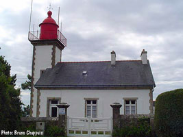
FR 191
[FR96D] |
Pointe de Morgat
latitude 48° 13' 11" N longitude 4° 29' 49.5" W
Located on the south side of the Crozon peninsula, at the southern entrance to the Anse de Morgat, about 1.1 km southeast of the Morgat waterfront. (D 0826) ARLHS # FRA-364
Photo courtesy Bruno Chappuis [Carceller] |
|
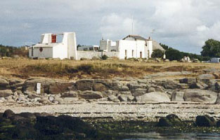
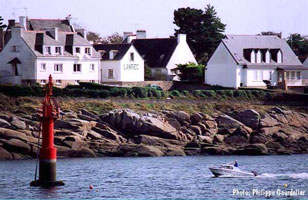
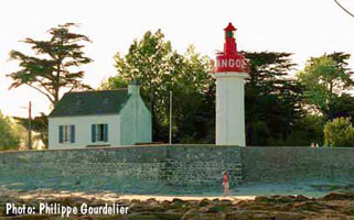
FR 192
[FR96E] |
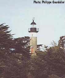
| Île Tristan (Douarnenez)
latitude 48° 6' 9.1" N longitude 4° 20' 18.5" W
Located on an island off the entrance to the harbor of Douarnenez, at the southeastern corner of the Baie de Douarnenez. Accessible only by boat. (D 0830) ARLHS # FRA-063
Photo courtesy Philippe Gourdelier [Carceller] |
FR 193
[FR96F] |
Pointe du Millier
latitude 48° 5' 55.6" N longitude 4° 27' 55.6" W
Located on a headland on the south side of the Baie de Douarnenez, about 5 km northeast of Beuzec-Cap-Sizun. (D 0836) ARLHS # FRA-360
Photo courtesy Jean Marc Cevaër [Flickr] |
|
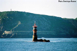
FR 194
[FR101] |
| Tévennec
Located on a small island about 5 km northwest of the Pointe du Raz. Accessible only by boat. (D 0866) ARLHS # FRA-058
Photo courtesy marinas.com [marinas.com] |
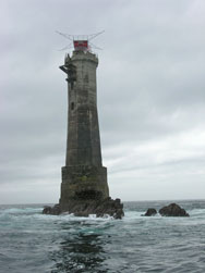
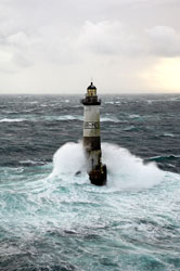
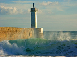
FR 195
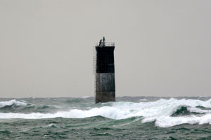
[FR99] |
Ar-Men
The Atlantic crashes relentlessly, and often spectacularly, against this most exposed of lighthouses
Jean Guichard has famous photos of massive waves sweeping around the tower. Located 8 km west of Île de Sein. photos (D 0852) ARLHS # FRA-001
Photo courtesy Boisecq Erwan [panoramio] |
|
FR 196
[FR100] |
| Île de Sein (Men-Brial)
latitude 48° 2' 17.1" N longitude 4° 50' 57.5" W
The island is accessible by passenger ferry from Audierne. Located at the western point of the island, about 1.6 km west of the harbor. ferry (D 0856) ARLHS # FRA-066
Photo courtesy Claude Mauguier [chemineur] |
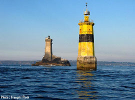
FR 197
[FR102] |
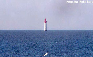
La Vieille
latitude 48° 2' 26.7" N longitude 4° 45' 23.2" W
The lighthouse can be seen from Pointe du Raz. The second light (on the left in the focus of the photo below). (D 0870) ARLHS # FRA-027
Photo courtesy PietroIzzo [Flickr] |
|
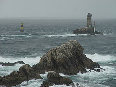
FR 198
[FR102A] |
| Feu de la Plate
latitude 48° 2' 25" N longitude 4° 45' 24.4" W
The light behind is La Vieille, shown above. This light is easily confused with La Plate. FR 67 (D 0872)
Photo courtesy François Floch [Carceller] |
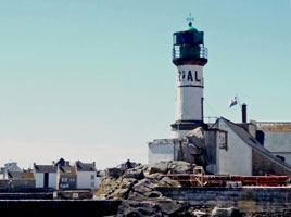
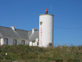
FR 199
[FR101A] |
Pointe de Lervily
latitude 48° 3.1" N longitude 4° 33' 55.7" W
Located on a headland projecting into the Baie d'Audierne about 3 km south of Esquibien. (D 0874) ARLHS # FRA-336
Photo courtesy J.P. Chapalain [Flickr] |
|
FR 200
[FR101D] |
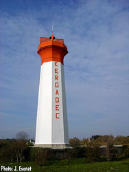
| Kergadec (feu postérieur)
latitude 48° 57.4" N longitude 4° 32' 46.3" W
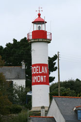
Located on a hill on the southeast side of Audierne. (D 0877.1)
Photo courtesy J. Evenat [Carceller] |
FR 201
[FR101B] |
Trescadec (feu antérieur)
latitude 48° 44.7" N longitude 4° 32' 47.7" W
Located on the coastal road west of the Audierne harbor entrance. ARLHS # FRA-789
Photo courtesy *Christian [Flickr] |
|
FR 202
[FR101C] |
| Raoulic (feu antérieur)
latitude 48° 33.1" N longitude 4° 32' 26.6" W
The Feu de Kergadec (below) is the rear light of this entrance range for Audierne. Located at the end of the Jetée de Raoulic, on the west side of the entrance to the harbor of Audierne. (D 0877) ARLHS # FRA-447
Photo courtesy Mr. Fenwick [Flickr] |
FR 203
[FR101E] |
Pors-Poulhan
latitude 47° 59' 5.6" N longitude 4° 27' 51.1" W
Located on the west side of the entrance to the small harbor of Pors-Poulhan, just off the Rue de l'Océan, about 4 km southeast of Plouhinec. (D 0884) ARLHS # FRA-746
Photo courtesy Yann Lautredou [Flickr] |
|
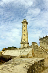
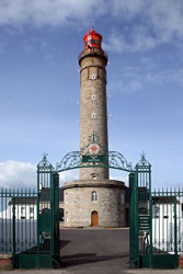
FR 204
[FR103] |
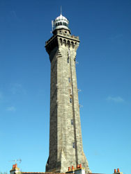
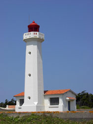
| Eckmühl
latitude 47° 47' 53.4" N longitude 4° 22' 21.1" W
Located in Saint-Pierre, on the point of Penmarc'h, about 3 km southwest of the town of Penmarc'h. (D 0890) ARLHS # FRA-256
Photo courtesy Dirk van der Eecken [Flickr] |
FR 205
[FR103A] |
Men-Hir
latitude 47° 47' 44" N longitude 4° 23' 59.1" W
Located on an exposed rock at the western end of the Penmarc'h reef, about 2 km west of the Pointe de Penmarc'h. (D 0892) ARLHS # FRA-353
Photo courtesy Alexander Trabas [ListOfLights] |
|
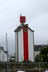
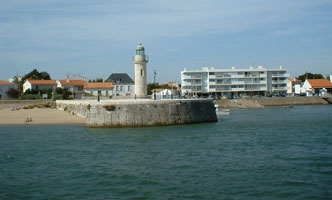
FR 206
[FR103B] |
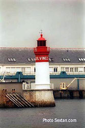
| Môle de Guilvinec
latitude 47° 47' 30.4" N longitude 4° 17' 5.7" W
Guilvinec is a fishing port about 5 km southeast of Penmarc'h. The harbor opens to the west, with the entrance being a narrow opening between two moles. Located at the end of a spur off the north mole (D 0900) ARLHS # FRA-595
Photo courtesy Sextan.com [Carceller] |
FR 207
[FR103C] |
Môle de Léchiagat (Rear)
latitude 47° 47' 26.7" N longitude 4° 17' 11" W
Located at the end of the south breakwater, which extends beyond the end of the entrance moles. Site and tower closed; mole is too narrow and exposed for walking. (D 0896.1) ARLHS # FRA-595
Photo courtesy Alexander Trabas [ListOfLights] |
|
FR 208
[FR103D] |
| Lost-Moan
latitude 47° 47' 0.7" N longitude 4° 16' 45.9" W
Located in the Guilvinec harbor. (D0898)
Photo courtesy Alexander Trabas [ListOfLights] |
FR 210
[FR103G] |
| La Perdrix
latitude 47° 50' 14.8" N longitude 4° 9' 58.3" W
Located on a shoal in the entrance to the Pouldon estuary, between Loctudy and Île Tudy. Accessible only by boat, but easily seen from shore on either side. ARLHS # FRA-588
Photo courtesy Christophe Alary [Flickr] |
FR 211
[FR103H] |
Pointe de Combrit (feu antérieur)
latitude 47° 51' 51.4" N longitude 4° 6' 47.1" W
Located on the coast west of the Pointe de Combrit, on the southwest side of Sainte-Marine. (D 0914.1) ARLHS # FRA-245
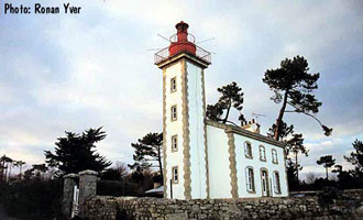
Photo courtesy Ronan Yver [Carceller] |
|
FR 212
[FR103J] |
| Pointe du Coq (feu antérieur)
latitude 47° 52' 18.2" N longitude 4° 6' 42.3" W
Located in Bénodet, on the east side of the entrance to Odet estuary and close to the Fort du Coq (1862). (D 0913.9) ARLHS # FRA-747
Photo courtesy raphodon [Flickr] |
FR 213
[FR103K] |
[La] Pyramide (feu postérieur)
latitude 47° 52' 29.3" N longitude 4° 6' 46.5" W
Located on the Corniche de l'Estuaire in Bénodet, about 350 m northeast of the Pointe du Coq light (visible on the right in this photo).
This is the common rear light for both Pointe de Combrit and La Pyramide (D 0914) ARLHS # FRA-195
Photo courtesy id4x [Flickr] |
![[La] Pyramide](CE/FranceW/Pyramide.jpg)
|
Concarneau thru Lorient
Lights 214 to 264 Concarneau Area
FR 214
[FR104] |
| Île aux Moutons
latitude 47° 46' 28.3" N longitude 4° 1' 40.4" W
Located on a small island about 11 km southeast of Bénodet and a similar distance southwest of Concarneau. Accessible only by boat. (D 0918) ARLHS # FRA-043
Photo courtesy Claude Carnot [Flickr] |
FR 215
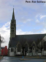
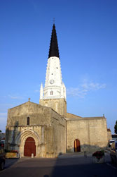
[FR104C] |
Beuzec (2nd feu postérieur)
In the steeple of a church located atop a hill in Beuzec-Conq, about 2.5 km northeast of the Feu de la Croix in Concarneau. (D 0390) ARLHS # FRA-197
Photo courtesy Alain Guichaoua [Carceller] |
|
FR 216
[FR104B] |
| Kériolet (Beuzec) (1st feu postérieur)
This was the original rear light of the La Croix range; it stands 1875 m northeast of the Feu de la Croix. Located on a hillside on the northeastern edge of Concarneau. ARLHS # FRA-792
Photo courtesy Alain Guichaoua [Carceller] |
FR 217
[FR104A] |
La Croix (feu antérieur)
The lighthouse is named for its location, the Place de la Croix, Concarneau. (Note: There is another Feu de la Croix near Trieux in northern Brittany). Located on the west side of the entrance to the harbor of Concarneau from the Baie de la Forêt. FR 105C (D 0928) ARLHS # FRA-025
Photo courtesy Alain Guichaoua [Carceller] |
|
FR 218
[FR104D] |
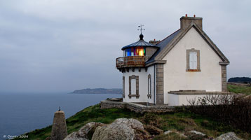
| Lanriec
Located on the east side of the Concarneau harbor entrance in Lanriec. (Note that the named light is in the background, behind the post in the water.) (D 0932) ARLHS # FRA-581
Photo courtesy Philippe Gourdelier [Carceller] |
FR 219
[FR104E] |
Pouldohan
Located on a point of land on the north side of the entrance to the Baie de Pouldohan, at the end of the Route de Grignallou in Trégunc. (D 0940) ARLHS # FRA-793
Photo courtesy John Cristophe Fichou [PharesFrance] |
|
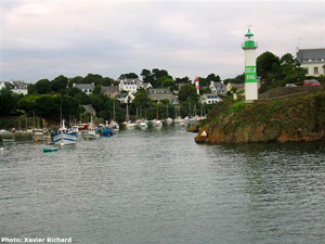
Trévignon-Doëlan Area
FR 220
[FR104F] |
| Pointe de Trévignon
latitude 47° 47' 36" N longitude 3° 51' 18" W
Located on a prominent point at Trévignon, near the yacht harbor. (D 0944) ARLHS # FRA-524
Photo courtesy Anke and Jens [seiten] |
FR 221
[FR106] |
Île Penfret
Located on an island, largest island of the group known as the Archipel des Glénan, about 18 km south southwest of Concarneau and 11 km southwest of Trévignon. ARLHS # FRA-047
Photo courtesy JL Keszler [Flickr] |
|
FR 222
[FR110H] |
| Port Crouesty (feu postérieur)
This plain modern lighthouse guides vessels into the port on the east side of Arzon. Located on the east side of the harbor. (D 1055.1) ARLHS # FRA-417 |
FR 223
[FR104G] |
Port Manec'h
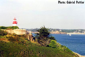
According to Fichou, this was the first directional light (feu à secteur) installed in France. Located on a bluff overlooking the west side of the entrance to the Aven estuary, off the Rue du Port in Port Manec'h. (D 0946) ARLHS # FRA-429
Photo courtesy Gabriel Pottier [Carceller] |
|
FR 224
[FR104H] |
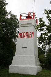
| Merrien
Located on a bluff overlooking the west side of the entrance to the narrow harbor of Merrien about 4 km south of Moëlan-sur-Mer. (D 0952) ARLHS # FRA-358
Photo courtesy Alexander Trabas [ListOfLights] |
Île de Groix
FR 227
[FR105] |
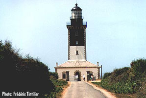
Pen-Men
latitude 47° 38' 51.2" N longitude 3° 30' 34.8" W
Located in a nature reserve at the west end of the Île de Groix island. Ile (D 0962) ARLHS # FRA-387
Photo courtesy Frédéric Tintilier [Carceller] |
|
|
|
FR 228
[FR105A] |
| Port Tudy Môle du Nord
latitude 47° 38' 43.1" N longitude 3° 26' 44.1" W
Located at the end of the north breakwater enclosing the harbor of Port Tudy, on the north side of Île de Groix. Ile (D 0966) ARLHS # FRA-437
Photo courtesy Nomad Photography [Flickr] |
FR 229
[FR105B] |
Port Tudy Môle de l'Est
latitude 47° 38' 40.7" N longitude 3° 26' 46.9" W
Located at the end of the east breakwater enclosing the harbor of Port Tudy, on the north side of Île de Groix. Accessible by walking the mole, there are also excellent views from ferries arriving from Lorient. (D 0964) ARLHS # FRA-436
Photo courtesy Jo Schmaltz [Flickr] |
|
Lorient Area
FR 231
[FR106A] |
| Lomener
Located on the waterfront on the east side of Lomener, a fishing port about 12 km southeast of Lorient. (D 0961) ARLHS # FRA-592
Photo courtesy Alexander Trabas [ListOfLights] |
FR 232
[FR106D] |
Kernével Feu Postérieur
This is the rear light of a downstream range that guides ships outbound from the Rade de Pen-Mané, the main harbor of Lorient. The front light is on a skeletal tower. Located in the east end of Larmor-Plage, 290 m southwest of the front light. (D 0996.1) ARLHS # FRA-327
Photo courtesy Alexander Trabas [ListOfLights] |
|
FR 233
[FR106E] |
| Lorient Feu Postérieur (La Perrière)
The original light, was atop the steeple of the Église de Saint-Louis; this historic church was destroyed in 1944. The modern light is on a 82 ft tower more than 1 km to the south. Located in the Arsenal, adjacent to the inner harbor of Lorient. (D 0971.1) ARLHS # FRA-347
Photo courtesy Alexander Trabas [ListOfLights] |
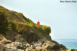
FR 234
[FR105C] |
Pointe de la Croix (Pointe de Surville)
This light was initially established within the walls of the historic Fort de Surville, one of the fortifications guarding the approach to Lorient. Two taller lighthouses, built in 1830 and 1845, had to be removed because they came into the line of fire of the fort's artillery. Finally the light was removed from the fort to eliminate this problem. Located at the eastern point of the island. (Not to be confused with two other lights such as FR 104A (D 0968) ARLHS # FRA-253
Photo courtesy Valentine Verdet [Carceller] |
|
FR 235
[FR106F] |
Kerbel (Poulfanc Feu Postérieur) |
The light was found to be not high enough, so the lighthouse was replaced by a new tower in 1913. ARLHS # FRA-798 |
FR 237
[FR106C] |
| Les Sœurs (Port-Louis Feu Antérieur)
This is the front light of the entrance range for Lorient. The rear lighthouse, in Port-Louis, has been replaced by a skeletal tower (see D0971.1). Located about 500 m southwest of the Port-Louis waterfront. Accessible only by boat. (D 0971) ARLHS # FRA-337
Photo courtesy Alexander Trabas [ListOfLights] |
FR 238
[FR106B] |
Les Trois Pierres
Located in the entrance to the Rade de Lorient, roughly 1.5 km from either side. Accessible only by boat, there should be good views from Gâvres to the east or Larmor-Plage to the north. (Don't confuse with Île Molène.) FR 89F (D 0974) ARLHS # FRA-589
Photo courtesy Gardien [Carceller] |
|
Quiberon Area
FR 239
[FR106H] |
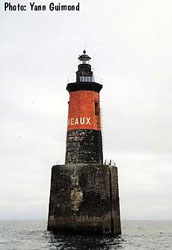
| Les Birvideaux
Located in the open Atlantic about 13 km west of Quiberon. One significant fact about this light is that it took 54 years to construct it (from 1880 to 1934). (D 1014)
Photo courtesy Yann Guimond [Carceller] |
FR 240
[FR106J] |
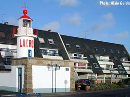
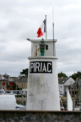
Port Maria (Quiberon)
Located on the waterfront at the foot of the Rue du Phare in Quiberon (D 1016) ARLHS # FRA-432
Photo courtesy tml [Flickr] |
|
FR 241
[FR106K] |
| Port Maria Jetée du Sud
latitude 47° 28' 32.8" N longitude 3° 7' 19.1" W
Located at the end of the breakwater, which encloses the southwest side of Port Maria's harbor. (D 1017) ARLHS # FRA-612 |
FR 242
[FR106L] |
Port Maria Môle Est
latitude 47° 28' 35.4" N longitude 3° 7' 22.5" W
Located at the end of the east mole, directly in front of the Phare de Port Maria (see above.). ARLHS # FRA-613
Photo courtesy Philippe Manguin [Flickr] |

|
FR 243
[FR106N] |
| Port Haliguen Jetée Nord
latitude 47° 29' 20.6" N longitude 3° 6' 1.4" W
Port Haliguen now has 4 lights, the original light (above) and 3 new ones. This photo shows the new lights (including the North Jetee in the middle.) (D 1026.2)
Photo courtesy Phillippe Manguin [Flickr] |
FR 244
[FR106O] |
Old Port Haliguen
latitude 47° 29' 10.2" N longitude 3° 6' 5.8" W
Located on the old breakwater at Port Haliguen on the northeast side of Quiberon. ARLHS # FRA-585
Photo courtesy Guillaumeo [Flickr] |
|
FR 245
[FR106P] |
| Port Haliguen Vieille Jetée
latitude 47° 29' 18.1" N longitude 3° 5' 58.6" W
Located at the original end of the breakwater on the south side of the harbor, this location is now an elbow in the extended breakwater. (D 1026) ARLHS # FRA-422 |
FR 245P
[FR108] |
Pointe des Chats
latitude 47° 37' 18" N longitude 3° 25' 18" W
Located at the southeastern point of the Île de Groix island, about 2 km southeast of the village of Locmaria. (D 0970) ARLHS # FRA-238
Photo courtesy Valentine Verdet [Carceller] |
|
Belle-Île
FR 248
[FR110] |
| Les Grands Cardinaux
This lighthouse guards the southern entrance to the Baie de Quiberon. Located on a rocky shoal about 4 km southeast of Hoëdic. Accessible only by boat. ARLHS # FRA-017
Photo courtesy Eric Guéret [Flickr] |
Southeastern Morbihan
FR 249
[FR110A] |
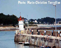
Trinité-sur-Mer
Located on the south wharf in Trinité-sur-Mer, on the west side of the Crac'h estuary at the northern end of the Baie de Quiberon. (D 1052) ARLHS # FRA-525
Photo courtesy Marie-Christine Terraillon [Carceller] |
|
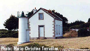
FR 250
[FR110C] |
| Kernevest (Crac'h Entrée Feu Postérieur)
Located beside the road on the east side of the Crac'h estuary, 560 m northwest of the front light. ARLHS # FRA-328
Photo courtesy Xavier Bonneyrat [Flickr] |
FR 251
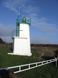
[FR110B] |
Saint-Philibert (Crac'h Entrée Feu Antérieur)
Located at the point of the Saint-Philibert peninsula, marking the east side of the entrance to the Crac'h estuary. ARLHS # FRA-499
Photo courtesy Marie-Christine Terraillon [Carceller] |
|
FR 252
[FR110D] |
Port Navalo (1840) |
Built in 1840, replaced in 1895.Located on Rue du Phare at the eastern entrance to the Golfe du Morbihan in Arzon. ARLHS # FRA-434 |
FR 253
[FR110E] |
Port Navalo (1895)
latitude 47° 32' 53.6" N longitude 2° 55' 4.9" W
Located on Rue du Phare at the eastern entrance to the Golfe du Morbihan in Arzon. (D 1054) ARLHS # FRA-435
Photo courtesy Jerome [Flickr] |
|
FR 255
[FR110F] |
| Crouesty Jetée du Nord
latitude 47° 32' 29" N longitude 2° 54' 7.8" W
Located on the north jetty at the entrance to Crouesty harbor, on the east side of Arzon. (D 1055.4) ARLHS # FRA-662
Photo courtesy Alexander Trabas [ListOfLights] |
FR 256
[FR110G] |
Crouesty Jetée du Sud
latitude 47° 32' 27.1" N longitude 2° 54' 6" W
Located on the south jetty at the entrance to Crouesty harbor, on the east side of Arzon. (D 1055.6) ARLHS # FRA-410
Photo courtesy Alexander Trabas [ListOfLights] |
|
FR 257
[FR110J] |
| Saint-Jacques-en-Sarzeau
Located at the end of the mole in St. Jacques-en-Sarzeau, about 8 km south southwest of Sarzeau on the Presqu'île de Rhuys. (D 1056) ARLHS # FRA-617
Photo courtesy Alexander Trabas [ListOfLights] |
FR 258
[FR111] |
Penlan
latitude 47° 30' 58.7" N longitude 2° 30' 7.2" W
North side of mouth of La Vilaine River. (D 1064) ARLHS # FRA-384
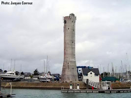
Photo courtesy Jacques Conreux [Carceller] |
|
FR 259
[FR111A] |
| Pointe du Scal (feu antérieur)
Until 1987 this was the front light of the Tréhiguier range. Located 500 m west of the Tréhiguier lighthouse on the south side of the Vilaine estuary. (D 1066) ARLHS # FRA-602
Photo courtesy Alexander Trabas [ListOfLights] |
FR 260
[FR111B] |
Tréhiguier (feu postérieur) |
In 1990 the deactivated lighthouse was conveyed to the commune (township) of Pénestin, which has renovated the building as a museum with exhibits on the mussel fishery of the estuary. Located in the village of Tréhiguier on the south side of the Vilaine estuary. ARLHS # FRA-520 |
FR 261
[FR111C] |
Mesquer (Pointe de Merquel)
Located on the jetty at the Pointe de Merquel, the south side of the entrance to the Marais Salants estuary north of Mesquer. (D 1072) ARLHS # FRA-735
Photo courtesy John Cristophe Fichou [PharesFrance] |
|
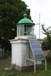
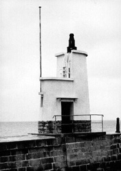
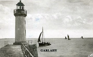
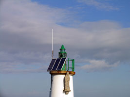
FR 263
[FR111E] |
La Turballe (Jetée de Garlahy)
Located on the breakwater sheltering the harbor of La Turballe. This photo is of the old light. The new light is very modern. (D 1076) ARLHS # FRA-298
Photo courtesy John Cristophe Fichou [PharesFrance] |
|
FR 264
[FR111F] |
![[Le] Croisic](CE/FranceW/Croisic.jpg)
| [Le] Croisic (Jetée de Tréhic)
latitude 47° 18' 30.2" N longitude 2° 31' 26.3" W
Located at the end of the breakwater on the west side of harbor entrance in Le Croisic. (D 1088) ARLHS # FRA-519
Photo courtesy C. Thompson [Flickr] |
FR 265
[FR109C] |
Le Palais Môle du Sud
latitude 47° 20' 49.2" N longitude 3° 9' 5.2" W
Located at the end of the mole enclosing the southeast side of the harbor of Le Palais, the principal town of Belle-Île. Good view from ferries arriving from the mainland (either Quiberon or Lorient). ARLHS # FRA-342
Photo courtesy Fabian [Flickr] |

|
Île d'Houat and Île d'Hoëdic
FR 266
[FR109E] |
| Île d'Houat (Jetée de St. Gildas)
Located at the end of the breakwater mole at the village of Île d'Houat, on the northeast side of the island. Accessible by walking the pier. ARLHS # FRA-627
Photo courtesy Sebastien LaGarde [Flickr] |
FR 267
[FR109B] |
Le Palais Môle du Nord
latitude 47° 20' 51.1" N longitude 3° 9' 3" W (D 1042) ARLHS # FRA-341 |

|
FR 268
[FR109A] |
| Sauzon
Located on the west side of the harbor of Sauzon, a small port on the northwestern coast of Belle-Île. There are also lights on the NW Jetée and the SE Jetée. (D 1044) ARLHS # FRA-469
Photo courtesy Jean-Pierre Robin [Carceller] |
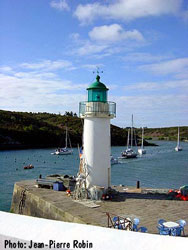
FR 269
[FR109] |
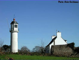
[Les] Poulains
The lighthouse was converted to solar power in 1999. Located on a small islet just off the northwestern point of Belle-Île. Accessible only by boat. (D 1030) ARLHS # FRA-059
Photo courtesy Giulio Marziale [Flickr] |
![[Les] Poulains](CE/FranceW/LesPoulains.jpg)
|
FR 270
[FR112] |
| Goulphar
latitude 47° 18' 39.2" N longitude 3° 13' 37.4" W
Located near Kervilahouen village and Port Goulphar. (D 1032) ARLHS # FRA-301
Photo courtesy Remi Jouan [wikipedia] |
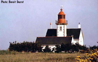
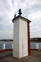
FR 271
[FR109D] |
Pointe de Kerdonis
latitude 47° 18' 31.3" N longitude 3° 3' 27.3" W
Located at the easternmost point of Belle-Île, about 5 km northeast of Locmaria. (D 1036) ARLHS # FRA-323
Photo courtesy Beoit Ducrot [Carceller] |
|
FR 272
[FR109G] |
Hoëdic Jetée |
Located at the end of the west jetty at the harbor of Hoëdic, on the north side of the island. ARLHS # FRA-797 |
Saint-Nazaire
Lights 286 through 307
FR 274
[FR113] |
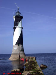
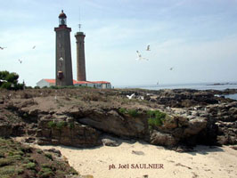
| Plateau du Four
Located on a rocky shelf, submerged at low tide, about 3 km west of the Pointe du Croisic, on the north side of the approach to the Loire. Accessible only by boat. (D 1080) ARLHS # FRA-052
Photo courtesy Joël Saulnier [PharesFrance] |
FR 275
[FR115A] |
Pointe d'Aiguillon
Located on the north bank of the Loire estuary on the east side of Saint-Marc-sur Mer, about 8 km southwest of Saint-Nazaire. (D 1114) ARLHS # FRA-167
Photo courtesy Benoit Ducrot [Carceller] |
|
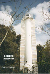
FR 276
[FR115D] |
Kerlédé (Portcé Feu Postérieur)
Located atop the bluff on the southwest side of Saint-Nazaire. (D 1106.1) ARLHS # FRA-510
Photo courtesy John Cristophe Fichou [PharesFrance] |
|
FR 277
[FR115C] |
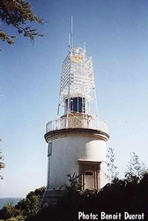
Portcé Feu Intermédiaire |
A 1-story masonry keeper's cottage, the light was shone through a window. Presumably the same keeper was responsible for the front light, which was displayed from a skeletal tower. Located atop the bluff on the southwest side of Saint-Nazaire. ARLHS # FRA-409 |
FR 278
[FR115B] |
Tour du Commerce |
The lighthouse was deactivated in 1897 when changes in the channel required moving the range. Located at Bonne-Anse on the southwest side of Saint-Nazaire. ARLHS # FRA-509 |
FR 279
[FR115E] |
Ville-ès-Martin
Located at the end of an abandoned jetty just off a point of land about 2.5 km southwest of the Port de Saint-Nazaire. Apparently accessible from the riverfront along the Rue Ferdinand Buisson. (D 1116) ARLHS # FRA-535
Photo courtesy Francisco Silva Gonzalez [Flickr] |
|
FR 280
[FR115F] |
![[Les] Morées](CE/FranceW/Morees.jpg)
| [Les] Morées
Located on a rocky shoal, the Banc des Morées, about 1 km east of Ville-ès-Martin. Accessible only by boat. (D 1118) ARLHS # FRA-363
Photo courtesy Alexander Trabas [ListOfLights] |
FR 281
[FR115G] |
Saint-Nazaire Jetée de l'Ouest
latitude 47° 15' 58.4" N longitude 2° 12' 14.9" W
The jetty lights mark the south entrance to the inner harbor, the Port de Saint-Nazaire, which is entered through locks that maintain a constant water level at the wharves. (D 1122) ARLHS # FRA-496
Photo courtesy Alexander Trabas [ListOfLights] |
|
FR 282
[FR115H] |
| Saint-Nazaire Jetée de l'Est
latitude 47° 15' 59.8" N longitude 2° 12' 9" W
Located at the end of the east jetty protecting the south entrance to the Port de Saint-Nazaire. (D 1124) ARLHS # FRA-494
Photo courtesy Nicolas Feuillebois [Flickr] |
FR 283
[FR115J] |
Saint-Nazaire Vieux Môle
latitude 47° 16' 16.7" N longitude 2° 11' 49.1" W
Located at the end of the Vieux (Old) Môle, off the Quai des Marées about 800 m northeast of the Jetée de l'Est lighthouse. (D 1126) ARLHS # FRA-495
Photo courtesy Alexander Trabas [ListOfLights] |
|
FR 284
[FR115K] |
| Paimboeuf
latitude 47° 17' 27.7" N longitude 2° 2' 13.5" W
Located at the end of the breakwater at the western end of the town waterfront, across the park from the Hotel de Ville, or town hall, on the south side of the Loire estuary about 12 km west of Saint-Nazaire. ARLHS # FRA-378
Photo courtesy Angela Bird [vendee] |
FR 285
[FR115] |
Le Grand Charpentier
Located on a rocky shoal about 3 km southwest of Saint-Marc-sur-Mer. Accessible only by boat, but there are good views from shore. (D 1104) ARLHS # FRA-014
Photo courtesy Denis Joly [Carceller] |
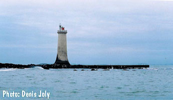
|
FR 286
[FR114] |
![[La] Banche](CE/FranceW/Banche.jpg)
| [La] Banche
Located on a rocky shelf about 8 km south of Le Pouliguen, marking the beginning of the approach to the Loire estuary, Saint-Nazaire, and Nantes. ARLHS # FRA-003
Photo courtesy Denis Joly [Carceller] |
Southern Loire-Atlantique
FR 287
[FR115L] |
Saint-Michel-Chef-Chef (Port de Comberge)
latitude 47° 10' 32.3" N longitude 2° 10' 0.8" W
Located on the south jetty at St.-Michel-Chef-Chef, a town on the south side of the Loire entrance about 7 km north of La Plaine-sur-Mer. (D 1105) ARLHS # FRA-593
Photo courtesy Alexander Trabas [ListOfLights] |
|
FR 288
[FR115N] |
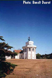
| Pointe Saint-Gildas
latitude 47° 8' 0.5" N longitude 2° 14' 45" W
Located at Pointe Saint-Gildas, marking the south side of the entrance to the Loire estuary, about 4 km west of La Plaine-sur-Mer. (D 1150) ARLHS # FRA-479
Photo courtesy Benoǐt Ducrot [Carceller] |
|
|
FR 289
[FR115P] |
Pornic (Pointe de la Noëveillard)
Located on the west side of entrance to the harbor of Pornic, on the Baie de Bourgneuf about 30 km south of Saint-Nazaire. (D 1156) ARLHS # FRA-372
Photo courtesy Robert [Carceller] |
|
FR 290
[FR115R] |
![[Le] Collet](CE/FranceW/Collet.jpg)
| [Le] Collet (Port de Collet)
latitude 47° 1' 47.7" N longitude 1° 58' 57.9" W
Located at the entrance to the Port de Collet in Moustiers-en-Retz, about 3 km southwest of Bourgneuf-en-Retz. (D 1157) ARLHS # FRA-738
Photo courtesy Alexander Trabas [ListOfLights] |
FR 291
[FR115S] |
Étier des Brochets (Port des Brochets)
Brochets is a small oyster-fishing village on the southwestern shore of the Baie de Bourgneuf. Located about 3 km northwest of Bouin. (D 1160) ARLHS # FRA-541
Photo courtesy Robert [Carceller] |
|
FR 292
[FR115T] |
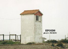
| Port du Bec de l'Époids
latitude 46° 56' 24.9" N longitude 2° 4' 27.7" W
Located on the east side of the harbor entrance at L'Époids, about 3 km northwest of Beauvoir-sur-Mer. (D 1161) ARLHS # FRA-542
Photo courtesy Robert [Carceller] |
Île de Noirmoutier Area
FR 293
[FR115U] |
Noirmoutier-en-l'Île (Jetée Heaux, Jetée des Îlots)
latitude 46° 59' 16.4" N longitude 2° 13' 8.7" W
Located at the end of a 1 km long jetty protecting the harbor of Noirmoutier-en-l'Île. (D 1164) ARLHS # FRA-634
Photo courtesy Alexander Trabas [ListOfLights] |
|
FR 294
[FR115V] |
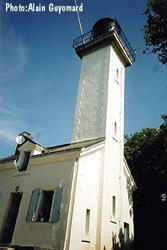
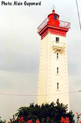
| Pointe des Dames
latitude 47° 52.2" N longitude 2° 13' 21.8" W
Located on the northeastern corner of the island, about 2 km northeast of the Noirmoutier-en-l'Île waterfront. (D 1162) ARLHS # FRA-254
Photo courtesy Alain Guyomard [Carceller] |
FR 298
[FR116B] |
| Goulet de Fromentine Nord (Tourelle du Milieu)
latitude 46° 53' 35.1" N longitude 2° 9' 37.5" W
Located on the southwest coast of the Île de Noirmoutier, about 2 km west of L'Épine. (D 1170) ARLHS # FRA-637
Photo courtesy Alexander Trabas [ListOfLights] |
FR 299
[FR116C] |
Goulet de Fromentine Sud (Tourelle de Bois-Vinet) |
Probably a duplicate entry of the light below (but listed twice by the ARLHS) ARLHS # FRA-802 |
FR 300
[FR116D] |
Pointe Notre-Dame-des-Monts (Fromentine)
latitude 46° 53' 26" N longitude 2° 9' 39.5" W
Les Monts (mountains) is a reference to prominent sand dunes south of the Goulet de Fromentine entrance. Located on the west side of the harbor at La-Barre-des-Monts, on the mainland just inside the Goulet. (D 1172) ARLHS # FRA-374
Photo courtesy Robert [Carceller] |
|
Île d'Yeu
FR 301
[FR116G] |
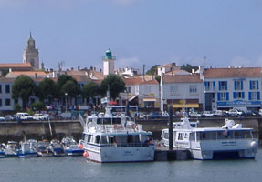
| Port-Joinville Feu Postérieur
Originally this was the rear light of the harbor entrance range. This lighthouse on the Ile d'Yeu stands among the houses in the centre of the island's capital Port-Joinville, fairly near the church. The island is reached from mainland France by ferry all year round from Fromentine. ARLHS # FRA-628
Photo courtesy Angela Bird [vendee] |
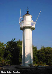
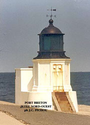
FR 302
[FR116F] |
Port-Joinville (Port-Breton, Quai du Canada) (feu anté
latitude 46° 43' 35.4" N longitude 2° 20' 54.6" W
Originally this was the front light of the harbor entrance range. Located at the head of the quay on the west side of the inner harbor. (D 1184) ARLHS # FRA-567
Photo courtesy John Cristophe Fichou [PharesFrance] |
|
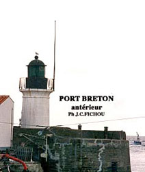
FR 303
[FR116E] |
| Port-Joinville Jetée Nord-Ouest (Port-Breton, Le Tourneau)
latitude 46° 43' 47" N longitude 2° 20' 49.5" W
Port-Joinville, originally called Port-Breton, is the point of arrival for ferries from the mainland. Located on the northwest jetty. (D 1180) ARLHS # FRA-629
Photo courtesy John Cristophe Fichou [PharesFrance] |
FR 304
[FR116H] |
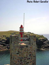
[Les] Chiens-Perrins (Pointe du But)
latitude 46° 44' 7.8" N longitude 2° 23' 41.6" W
Lighthouse located on a rocky ledge about 800 m off the Pointe du But, the northwestern point of the island, the fog signal building is located at the tip of the point. ARLHS # FRA-630
Photo courtesy Alain Guyomard [Carceller] |
![[Les] Chiens-Perrins](CE/FranceW/Perrins.jpg)
|
FR 305
[FR117] |
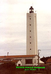
| Île d'Yeu (Grand Phare, Petite Foule)
latitude 46° 43' 3.2" N longitude 2° 22' 55.6" W (D 1176) ARLHS # FRA-536
Photo courtesy John Cristophe Fichou [PharesFrance] |
FR 306
[FR117G] |
Port de la Meule
Not really a lighthouse, but clearly a historic beacon. Located at the tiny small boat harbor of La Meule, on the south coast of the island. (D 1188)
Photo courtesy Robert [Carceller.] |
|
FR 307
[FR118] |
| Pointe des Corbeaux
latitude 46° 41' 36" N longitude 2° 17' 42" W
It was constructed in 1950 to replace an earlier tower destroyed during World War II. Along with the Île d'Yeu lighthouse, it is one of two lighthouses on the island to have been designed by Maurice Durand; construction of both was completed in the same year.
located on the eponymous point on the Île d'Yeu which is at the extreme southwestern end of the island. (D 1186)
Photo courtesy Christophe Boxus [ListOfLights] |
Charente-Maritime
lights 308 through 345 Saint-Gilles-Croix-de-Vie
FR 308
[FR118A] |
Pointe de Grosse-Terre
The lighthouse was built as a landfall light because development along the shoreline had obscured mariners' view of the harbor entrance lights. Located on a point of land just off the D6 coastal highway on the west side of Saint-Gilles-Croix-de-Vie. (D 1189.6) ARLHS # FRA-310
Photo courtesy Alain Guyomard [Carceller] |

|
FR 309
[FR118C] |
| Saint-Gilles (Tour Joséphine)
latitude 46° 42' N longitude 1° 57' W
Located on the jetty not far from the Boisvinet light; the keeper's house is onshore nearby at 9 Rue Jean Cristau. ARLHS # FRA-636
Photo courtesy Hazel Tsoi [Flickr] |
FR 310
[FR118B] |
Saint-Gilles Jetée de Boisvinet
latitude 46° 41' 37.4" N longitude 1° 57' 9.6" W
Located at the end of the jetty on the west side of the entrance to the Rivière de Vie and the inner harbor of Saint-Gilles-Croix-de-Vie. (D 1191) ARLHS # FRA-249
Photo courtesy Alexander Trabas [ListOfLights] |
|
Les Sables d'Olonne
FR 313
[FR118F] |
| Les Barges
Located on a rocky reef called La Grande Barge, about 2.5 km west of the beach on the west side of Les Sables d'Olonne. (D 1198) ARLHS # FRA-010
Photo courtesy Erwan [Flickr] |
FR 314
[FR118G] |
L'Armendèche
latitude 46° 29' 24" N longitude 1° 48' 18" W
Located just behind the beach, off the Route Bleue, the shoreline boulevard on the west side of Les Sables d'Olonne. (D 1196)
Photo courtesy La Roche sur Yon [Flickr] |
|
FR 315
[FR118H] |
| Jetée de Saint-Nicolas
latitude 46° 29' 14.5" N longitude 1° 47' 31.7" W
The Jetée de Saint-Nicolas is the breakwater mole sheltering the west side of the harbor entrance. There is a very nice (if you understand French) explanation for the following series of 5 lights on Carceller's site. carceller (D 1200) ARLHS # FRA-465
Photo courtesy Erwan [Flickr] |
FR 316
[FR118J] |
Tour d'Arundel feu postérieur (Tour de la Chaume)
latitude 46° 29' 37.8" N longitude 1° 47' 44.4" W
The Tour d'Arundel is on the waterfront of La Chaume, on the opposite side of the Les Sables-d'Olonne harbour channel from Les Sables itself. La Chaume is accessible from Les Sables by car via Boulevard de l'Ile Vertime, or by a 2-minute ferry-ride across the harbour from Quai Guiné. (D 1204.1) ARLHS # FRA-174
Photo courtesy Angela Bird [vendee] |
|
FR 317
[FR118K] |
| Jetée des Sables
latitude 46° 29' 26.6" N longitude 1° 47' 30.9" W
Located at the end of the jetty on the east side of the harbor entrance at Les Sables d'Olonne. This photo shows the Jetée de Saint-Nicolas on the right. FR 118H (D 1204) ARLHS # FRA-466
Photo courtesy Yann Guimond [Carceller] |
FR 318
[FR118L] |
L'Estacade (feu antérieur)
Located on the quay at the lower end of the Rue des Deux Phares in Les Sables d'Olonne. (D 1207)
Photo courtesy Anne-Marie Roussel [Carceller] |
|
FR 319
[FR118N] |
![[La] Potence](CE/FranceW/Potence.jpg)
| [La] Potence (feu postérieur)
The Rue des Deux Phares (Street of the Two Lighthouses) joins this lighthouse to the former front light, L'Estacade (see above). (D 1207.1) ARLHS # FRA-442
Photo courtesy Ann-Marie Roussel [Carceller] |
FR 319P
[FR118P] |
Port-Bourgenay Feu Antérieur
Located on the quay at Port-Bourgenay, the small boat harbor of Bourgenay-Querry-Pigeon, about 10 km east southeast of Sables d'Olonne. (D 1211) ARLHS # FRA-540
Photo courtesy Alexander Trabas [ListOfLights] |
|
Île de Ré
FR 320
[FR118S] |
![[La] Flotte](CE/FranceW/Flotte.jpg)
| [La] Flotte
Located at the end of the mole at La Flotte, on the north side of the island. (D 1230) ARLHS # FRA-285
Photo courtesy Caro2000 [Flickr] |
FR 321
[FR118U] |
Église St.-Étienne d'Ars-en-Ré
The tall steeple, a conspicuous landmark on the low western end of the island, has carried this prominent daymark for nearly 200 years. Located in the village of Ars-en-Ré.
Photo courtesy Didier LG [Flickr] |
|
FR 322
[FR118T] |
| Saint-Martin-de-Ré
latitude 46° 12' 26.6" N longitude 1° 21' 52.9" W
The lighthouse stands adjacent to the late seventeenth century Citadelle de St.-Martin-de-Ré, one of the best preserved French fortifications of that era and a popular tourist attraction. Located in St.-Martin-de-Ré about 7 km west of La Flotte on the north side of the island. (D 1226) ARLHS # FRA-489
Photo courtesy Caro2000 [Flickr] |
FR 323
[FR119A] |
Haut Banc du Nord (Les Baleineaux)
Located on a reef about 3 km northwest of the Pointe des Baleines. There is a good but rather distant view from the Phare des Baleines. (D 1216) ARLHS # FRA-002
Photo courtesy Alexander Trabas [ListOfLights] |
|
FR 324
[FR118Y] |
| Les Baleines (1682)
The original light was a fish-oil lamp in a stone lantern. Following bitter complaints from mariners, this apparatus was replaced in 1736 by a stronger lamp in a cast iron lantern. Reflectors were added in 1777 and replaced in 1820. ARLHS # FRA-642
Photo courtesy Sarah East [Flickr] |
FR 325
[FR118V] |
Fier d'Ars Feu Antérieur
The Fier d'Ars is the entrance channel to Ars-en-Ré from the lagoon to the north. Located on the shoreline north of Ars-en-Ré. (D 1223) ARLHS # FRA-801
Photo courtesy Amy Clendenin [Flickr] |
|
FR 326
[FR118X] |
| Fier d'Ars Feu Postérieur
According to Fichou, the light was moved to a metal post, which had to be moved again in 1960 to keep up with the shifting location of the channel. Located on the north side of Ars-en-Ré. (D 1223.1) ARLHS # FRA-283
Photo courtesy Alexander Trabas [ListOfLights] |
FR 327
[FR119B] |
Chanchardon
This lighthouse guides ships into the Pertuis d'Anticoche, the sound between the Île de Ré and the Île d'Oléron. Located about 6 km off the south coast of the Île de Ré, between La-Courard-sur-Mer and Ars-en-Ré. (D 1240) ARLHS # FRA-233
Photo courtesy Alexander Trabas [ListOfLights] |
|
La Pallice and La Rochelle
FR 328
[FR119D] |
La Pallice Môle d'Escale
latitude 46° 9' 44.7" N longitude 1° 14' 19.9" W |
Located on the breakwater mole and wharf enclosing the north side of the extended harbor of La Pallice. ARLHS # FRA-275 |
FR 329
[FR119E] |
La Pallice (Jetée du Nord)
latitude 46° 9' 28" N longitude 1° 13' 53.2" W |
Located at the end of the north mole of La Rochelle's traditional harbor. ARLHS # FRA-112 |
FR 330
[FR119] |
Chef-de-Baie Jetée Ouest
latitude 46° 9' 28.1" N longitude 1° 14' 29.3" W
Located on the west jetty of the Chef-de-Baie fishing harbor just southwest of the main harbor of La Pallice. (D 1248) ARLHS # FRA-136
Photo courtesy Alexander Trabas [ListOfLights] |
|
FR 331
[FR119G] |
| Chef-de-Baie Jetée Sud
latitude 46° 9' 17" N longitude 1° 14' 0.2" W
Located on the south jetty of the Chef-de-Baie fishing harbor just southwest of the main harbor of La Pallice. (D 1248.5) ARLHS # FRA-655
Photo courtesy Alexander Trabas [ListOfLights] |
FR 332
[FR119C] |
Pointe de Chauveau
latitude 46° 8' 2" N longitude 1° 16' 24.6" W
This lighthouse and its neighbor Le Lavardin are two of the first French lighthouses to be built in the open sea, both guard the approach to La Pallice and La Rochelle. Located about 1.2 km off the southeastern point of the Île de Ré. Good views from shore, with good timing it is possible to walk to the lighthouse at low tide. FR 119H (D 1238) ARLHS # FRA-009
Photo courtesy Jean-Michel Penin [Carceller] |
|
FR 333
[FR119H] |
![[Le] Lavardin](CE/FranceW/Lavardin.jpg)
| [Le] Lavardin
This lighthouse and the Pointe de Chauveau lighthouse flank the approach to the harbor of La Pallice. Located about 1.5 km southwest of Chef-de-Baie, La Pallice. FR 119C (D 1243) ARLHS # FRA-646
Photo courtesy Alexander Trabas [ListOfLights] |
FR 334
[FR119I] |
Tourelle Richelieu
latitude 46° 8' 53.8" N longitude 1° 10' 20.5" W
Located off the north side of the harbor about 1.6 km west of the downtown quay. Presumably it is possible to walk across the dam to the lighthouse at low tide. (D 1250) ARLHS # FRA-518
Photo courtesy Alexander Trabas [ListOfLights] |
|
FR 335
[FR119J] |
| La Rochelle Feu Antérieur
This range guides ships into the historic inner harbor of La Rochelle. Located on the Rue de l'Armide on the west side of the inner harbor. (D 1251) ARLHS # FRA-803
Photo courtesy trueblue2 [Flickr] |
FR 336
[FR119K] |
La Rochelle Feu Postérieur
This slender lighthouse rises straight out of the city's historic waterfront. Located on the Quai Vallin, at the east end of the inner harbor. (D 1251.1) ARLHS # FRA-340
Photo courtesy C. Tavernier [Flickr] |
|
FR 337
[FR119L] |
| Port des Minimes Jetée de l'Est (Digue de Bout Blanc)
latitude 46° 8' 50.2" N longitude 1° 10' 2.3" W
Located on the east jetty of the Port des Minimes, a modern facility about 2.5 km southwest of the inner harbor of La Rochelle. (D 1254.1) ARLHS # FRA-574
Photo courtesy Alexander Trabas [ListOfLights] |
FR 338
[FR119M] |
Port des Minimes Jetée de l'Ouest (Digue de Lazaret)
latitude 46° 8' 49.1" N longitude 1° 10' 8.8" W |
Located on the west jetty of the Port des Minimes, off the end of the Quai de Lazaret. ARLHS # FRA-575 |
FR 339
[FR119N] |
Pointe des Minimes Le Phare au Bout du Monde (replica)
latitude 46° 8' 15.9" N longitude 1° 10' 44.8" W
On the south side of the entrance to La Rochelle. (D 1253) ARLHS # FRA-601
Photo courtesy Genki David [Flickr] |
|
Île d'Aix and Charente
FR 340
[FR119O] |
| Île d'Aix
latitude 46° 35.4" N longitude 1° 10' 40.4" W
The island is accessible year-round by passenger ferry from Fouras, in the summer there is also ferry service from La Rochelle and Oléron. The lighthouse is located at the southern tip of the island. (D 1256) ARLHS # FRA-069
Photo courtesy Jacques Froissant [Flickr] |
FR 343
[FR119V] |
Pointe de la Perrotine (Boyardville)
latitude 45° 58' N longitude 1° 4' W
Located at the end of the south jetty at La Perrotine, a small port in the center of the northeast side of the island. (D 1276) ARLHS # FRA-658
Photo courtesy Anne Renard [Flickr] |
|
FR 346
[FR119U] |
| Tourelle Juliar
Located on a reef (exposed at low tide) about 3.25 km northeast of Château d'Oléron. (D 1277) ARLHS # FRA-652
Photo courtesy Alexander Trabas [ListOfLights] |
Southwest Coast
lights 348 to 389 Île d'Oléron
FR 348
[FR119T] |
Château d'Oléron Front
latitude 45° 53' 1.8" N longitude 1° 11' 27.2" W
The front light is on a small drum-shaped enclosure atop a corner of the fortress. (D 1278) ARLHS # FRA-115
Photo courtesy Isa Drilleau and J.C. Fichou [PharesFrance] |
|
FR 349
[FR119Tr] |
| Chateau d'Oléron Rear
latitude 45° 53' 8.1" N longitude 1° 11' 35.4" W
The rear light is located at the eastern point of the island, about 2.5 km north of the bridge from the mainland. (D 1278.1)
Photo courtesy Isa Drilleau and J.C. Fichou [PharesFrance] |
FR 350
[FR119X] |
Saint-Denis-d'Oléron Feu de Guidage
The light guides ships into the harbor of St.-Denis-d'Oléron, the major town at the northwest end of the island. Located just east of the harbor. (D 1274.4)
Photo courtesy Alexander Trabas [ListOfLights] |
|
FR 351
[FR119Y] |
| Saint-Denis-d'Oléron (Jetée de l'Est)
Located on the east jetty in St.-Denis-d'Oléron. (D 1274)
Photo courtesy elbert31 [Webshots] |
FR 352
[FR120J] |
Rocher d'Antioche
latitude 46° 3' 56.1" N longitude 1° 23' 42.5" W
Located on a rocky reef about 2.5 km northeast of the Pointe de Chassiron. Accessible only by boat in dangerous seas. (D 1272) ARLHS # FRA-508
Photo courtesy Alexander Trabas [ListOfLights] |
|
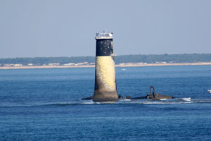
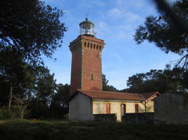
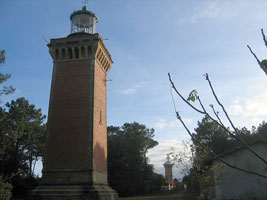
FR 353
[FR120] |
| Chassiron
latitude 46° 2' 4.9" N longitude 1° 24' 29.9" W
The present lighthouse carries a historic hexagonal Fresnel lens, one of the oldest 1° lenses in use. Located at the northwestern tip of the Île d'Oléron, at the end of the D734 highway about 3 km west of St.-Denis-d'Oléron. (D 1270) ARLHS # FRA-234
Photo courtesy Mickaël Davaze [Carceller] |
FR 354
[FR120K] |
La Cotinière
La Cotinière is a port in the center of the southwest side of the island. Located at the elbow of the Grand Jetée on the west side of the harbor. (D 1286) ARLHS # FRA-252
Photo courtesy Armel [Flickr] |
|
FR 356
[FR120N] |
Épi du Colombier
Located at the entrance to the inner harbor at La Cotinière. (D 1287) ARLHS # FRA-244
Photo courtesy Alexander Trabas [ListOfLights] |
|
FR 357
[FR121] |
| La Coubre
latitude 45° 41' 47.6" N longitude 1° 14' 0.5" W
Located off the D25 coastal highway about 4 km west of La Palmyre. (D 1290) ARLHS # FRA-133
Photo courtesy tiseb [Flickr] |
FR 358
[FR121D] |
La Palmyre (feu postérieur)
latitude 45° 39' 42.9" N longitude 1° 7' 14.8" W
The lighthouse is built near the center of the Parc de Loisirs, a large park on the north bank of the Gironde just west of St.-Palais-sur-Mer. Located off the D25 highway about 6.5 km west of La Palmyre and 5 km northwest of Saint-Palais-sur-Mer. (D 1294) ARLHS # FRA-381
Photo courtesy Robert [Carceller] |
|
FR 359
[FR121E] |
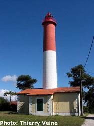
| Terre-Nègre (St.-Palais-sur-Mer) (feu antérieur)
latitude 45° 38' 46.3" N longitude 1° 6' 23.2" W
From 1852 to 1902 this was the rear light of a range, with La Falaise as the front light. Since 1960 it has served as a front light of a range with the rear light on the La Palmyre tower. Located close to the D25 highway on the west side of Saint-Palais-sur-Mer. (D 1294.1) ARLHS # FRA-503
Photo courtesy Thierry Veine [phares] |
FR 360
[FR121F] |
Le Chay (feu antérieur)
latitude 45° 37' 18.6" N longitude 1° 2' 25.9" W
Located on the Rue du Phare du Chay in Royan. (D 1312) ARLHS # FRA-582
Photo courtesy Arno Siering [ListOfLights] |
|
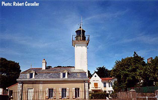
FR 361
[FR121G] |
| Saint-Pierre (feu postérieur)
latitude 45° 38' 2.1" N longitude 1° 1' 32.1" W
Located on a hill on the north side of Royan, 1.8 km northeast of the front lighthouse. (D 1312.1) ARLHS # FRA-804
Photo courtesy Arno Siering [ListOfLights] |
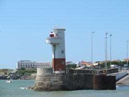
FR 362
[FR121H] |
Royan Jetée du Sud
latitude 45° 37' 7.3" N longitude 1° 1' 32.1" W
Located at the end of the breakwater mole enclosing the harbor of Royan. Excellent view from ferries crossing the Gironde from Royan to Pointe de Grave on the south shore. (D 1304) ARLHS # FRA-464
Photo courtesy Clare Clayton [lighthouseExplorer] |
|
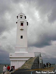
FR 364
[FR121K] |
Suzac (Phare aux Lapins) |
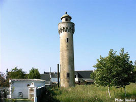
Located on a promontory in the Forêt de Suzac, about 2.5 km southeast of St.-Georges-de-Didonne. ARLHS # FRA-333 |
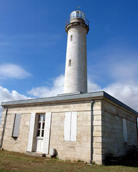
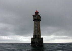
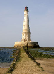
FR 365
[FR122] |
Courdouan
latitude 45° 35' 10.6" N longitude 1° 10' 24.1" W
A high-speed motorboat takes passengers to Cordouan in about 30 minutes. For information call the Office of Tourism of Verdon at 05 56 09 61 78.
Photo courtesy Thibault Grouas [Wikipedia] |
|
FR 366
[FR122B] |
| Pointe de Grave (feu postérieur)
latitude 45° 34' 6.8" N longitude 1° 3' 56.7" W
Located in Verdun-sur-Mer, near the terminal for ferries crossing the Gironde from Royan. (D 1310.5) ARLHS # FRA-155
Photo courtesy Alain Guyomard [Carceller] |
FR 367
[FR122C] |
Port Bloc Estacade Nord
Located on the south mole at Port Bloc in Verdun-sur-Mer, the terminal for ferries arriving from Royan. (D 1314) ARLHS # FRA-277
Photo courtesy Arno Siering [ListOfLights] |
|
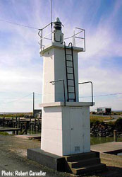
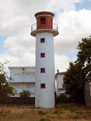
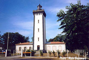
FR 368
[FR122A] |
| Saint-Nicolas (feu antérieur)
latitude 45° 33' 43.8" N longitude 1° 5' 0.9" W
Located just behind the ocean beach, 1550 m southwest of the Pointe de Grave lighthouse in Verdun-sur-Mer. This light looks pretty small out here on the beach. Check carefully the size of the door before making assumptions about size. (D 1310) ARLHS # FRA-497
Photo courtesy Bernard Caunésil [Carceller] |
FR 370
[FR122E] |
Trompeloup (feu antérieur) |
Located in the middle of the Gironde about 3 km southeast of Saint-Estèphe and 2650 m north of the Île de Patiras lighthouse. Accessible only by boat; there should be good views from the riverside D2 highway south of Saint-Estèphe. ARLHS # FRA-745 |
FR 371
[FR122F] |
Île de Patiras (feu postérieur)
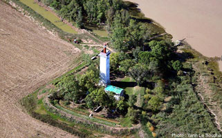
latitude 45° 12' 16.6" N longitude 42' 57.9" W
The Île de Patiras is an island in the middle of the Gironde opposite Pauillac. About 3 km long and 1.5 km wide, the island has been a various times a pirate base, leper colony, and place of exile for Jews from Bordeaux. Today it is the site of a large vineyard producing Bordeaux wine. Accommodations on the island are available. The lighthouse is near the northern tip of the island. The island is accessible only by boat, transportation from Pauillac can be arranged. ARLHS # FRA-812
Photo courtesy Yann Le Souchu [phares] |
|
FR 372
[FR123] |
| Hourtin Nord
latitude 45° 8' 31.5" N longitude 1° 9' 40.6" W
Located on a dune behind the ocean beach about 6 km south of Hourtin-Plage. There are two identical nearly towers (notated Nord and Sud). (D 1372) ARLHS # FRA-105
Photo courtesy Georges Schultz [wikipedia] |
FR 373
[FR123S] |
Hourtin Sud
latitude 45° 8' 24.8" N longitude 1° 9' 41.3" W
Located on a dune behind the ocean beach about 6 km south of Hourtin-Plage. There are two identical nearly towers (notated Nord and Sud). In this photo, Sud is the farther tower.
Photo courtesy Georges Schultz [wikipedia] |
|
FR 374
[FR124] |
| Cap Ferret
latitude 44° 38' 45.7" N longitude 1° 14' 55.4" W
Located at the end of the D106 highway in Cap-Ferret. Not to be confused (like I did) with FR494 which you will notice is spelled Ferrat. FR 494 (D 1378) ARLHS # FRA-226
Photo courtesy Jacques Froissant [Flickr] |
Landes
FR 375
[FR125A] |
Capbreton Jetée Nord
latitude 43° 39' 21.4" N longitude 1° 26' 54" W
The harbor at Capbreton is entered through a narrow cut, this lighthouse marks the north side of the channel. Located at the end of the breakwater mole of Capbreton. (D 1384) ARLHS # FRA-809
Photo courtesy David Sherwood [Flickr] |
|
FR 377
[FR125C] |
| Capbreton Estacade Sud
latitude 43° 39' 19.5" N longitude 1° 26' 50.6" W
Located adjacent to the wooden pier (estacade) on the south side of the entrance to Capbreton. (D 1386) ARLHS # FRA-808
Photo courtesy David Sherwood [Flickr] |
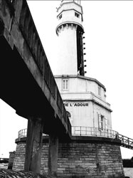
FR 378
[FR125G] |
Boucau Feu Postérieur
latitude 43° 31' 36.3" N longitude 1° 30' 49.5" W
Located on the south bank of L'Adour, 150 m east southeast of the front light, probably visible from the Avenue de l'Adour, which runs close to the bank. (D 1387.21) ARLHS # FRA-807
Photo courtesy ondacaracola [Flickr] |
|
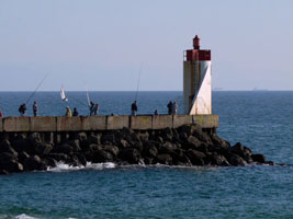
FR 379
[FR125F] |
| Boucau Feu Antérieur
latitude 43° 31' 37.9" N longitude 1° 30' 55.6" W
Located in the estuary, off the south bank; probably visible from the Avenue de l'Adour, which runs close to the bank. (D 1387.8) ARLHS # FRA-088
Photo courtesy ondacaracola [Flickr] |
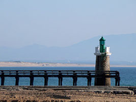
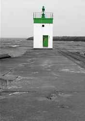
FR 380
[FR125E] |
L'Adour Sémaphore
latitude 43° 31' 40.9" N longitude 1° 31' 17" W |
Located a few feet off the south side of the Rivière de l'Adour just inside the entrance. ARLHS # FRA-813 |
FR 381
[FR125C] |
L'Adour Jetée Nord
latitude 43° 31' 49.3" N longitude 1° 31' 24.5" W
Located at the end of the jetty on the north side of the entrance to the Rivière de l'Adour, which is the boundary between Landes and Pyrénées-Atlantiques, about 3 km west of Boucau. (D 1387.3) ARLHS # FRA-202
Photo courtesy Arno Siering [ListOfLights] |
|
FR 383
[FR126] |
Pointe Saint-Martin (Biarritz)
latitude 43° 29' 37.7" N longitude 1° 33' 13.9" W
Located on the south bank of L'Adour, 150 m east southeast of the front light; probably visible from the Avenue de l'Adour, which runs close to the bank. (D 1410)
Photo courtesy Tony M [Flickr] |
|
FR 384
[FR126A] |
| Guéthary Feu Postérieur
Located atop a bluff at Guéthary, about 8 km southwest of Biarritz. (D 1413.1)
Photo courtesy Alexander Trabas [ListOfLights] |
FR 385
[FR126B] |
Pointe Sainte-Barbe Feu Antérieur
latitude 43° 23' 57.9" N longitude 1° 39' 51.9" W |
Located on the heights of the point, beyond the end of the Boulevard Thiers in Saint-Jean-de-Luz. (D 1414) ARLHS # FRA-473 |
FR 386
[FR126C] |
Pointe Sainte-Barbe Feu Postérieur
latitude 43° 23' 55.8" N longitude 1° 39' 36.8" W
340 m east southeast of the front light. (D 1416) ARLHS # FRA-814
Photo courtesy Benoit Le Goff [phares] |
|
FR 388
[FR126E] |
Saint-Jean-de-Luz Feu Postérieur
latitude 43° 23' 3.9" N longitude 1° 39' 59.1" W
Located on the west side of the inner harbor in Ciboure. (D 1420)
Photo courtesy Robert [Carceller] |
|
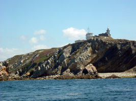
FR 389
[FR127] |
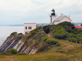
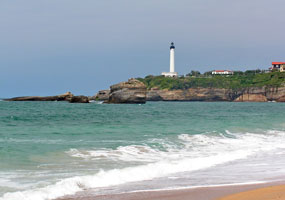
| Phare de Socoa St. Jean de Luz
latitude 43° 23' 42.1" N longitude 1° 41' 11.5" W
Located atop a steep bluff near the point of land at the east end of the bay, about 3 km northwest of Ciboure. (D 1424) ARLHS # FRA-470
Photo courtesy courtecuisse [Webshots] |
|
|
 Northern Spain

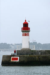
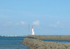
![[La] Teignouse](http://commons.wikimedia.org/wiki/Image:Phare-de-la-Teignouse.jpg)
.jpg)
![[Le] Pouliguen Jetée Sud](CE/FranceW/PouliguenSud.jpg)