|
This page shows the lighthouses of Syria. There aren't many as Syria doesn't have a big coastal area. Lights are numbered North to South. |
|
| SY 1 |
Ra's Al Basit |
Ra's al-Basit is a sharp, mountainous promontory about 15 km southwest of the Turkish border. The south side of the cape shelters a popular beach resort. Located at the tip of the cape. ARLHS # SYR-004 |
| SY 2 |
Ra's Al Fasuri |
Ra's al-Fasuri is a blunt headland about 25 km north of Lattakia. ARLHS # SYR-005 |
| SY 3 |
Al Burj
latitude 35° 35' 9.5" N longitude 35° 43' 2.7" E
Located on the point of Ra's ibn-Hani, about 12 km north of Lattakia. It is likely this is a closed area. ARLHS # SYR-001
Photo courtesy Syria Dept of [Tourism] |
|
|
|
| SY 4 |
Ra's Iban Hani |
ARLHS # SYR-006 |
|
|
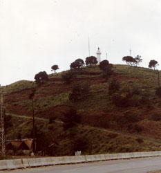
| SY 5 |
Lattakia Range Rear (Latakia)
latitude 35° 31' 40.7" N longitude 35° 46' 25.4" E |
Located near the waterfront in the midst of the commercial harbor of Lattakia. photo |
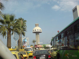
| SY 6 |
Lattakia Beacon (faux)
latitude 35° 31' 45.2" N longitude 35° 46' 31.1" E
This tall concrete tower is described by several photographers as a "lighthouse" or "beacon", but it does not appear to carry a light. More likely it is a harbor control tower. It is a short distance north of the Lattakia Range Rear Light.
Photo courtesy Tarek Miro (لا مانع اخي العزيز) [panoramio] |
|
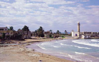
| SY 7 |
| Baniyas
latitude 35° 8' 48.7" N longitude 35° 55' 15.8" E
Located on a hill behind a headland about 5 km south southwest of Baniyas. (E 5923.5) ARLHS # SYR-002
Photo courtesy Alex Trabas [ListOfLights] |
| SY 8 |
Jazirat Arwad |
Arwad (originally known as Arado) is a roughly circular island 3 km southeast of the waterfront of Tartus. The fortress was originally built in the 12th century by crusaders, the Knights Templar, who held it until 1303. Subsequently it was rebuilt by the Ottomans. Passenger ferry service to the island is available photo (N 5924) ARLHS # SYR-003 |
|
|
 Cyprus
 Turkey
