This photo may be purchased from Marinas.com
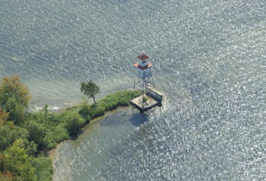
QC 202 Ash Island Front Range (Île Ash, Île aux Têtes)
latitude 45º
3' 34.2" N
longitude 73º 19'
41.4" W
This was a northbound (downstream) range guiding vessels in the northernmost end of Lake Champlain as they approached Ash Island, a large island in the river at Lacolle. Located on the south bank of the island, about ¼ mile south of the Lacolle railroad bridge and 3 miles north of the U.S. border.
|
|
This photo may be purchased from Marinas.com |
| <--back | home | next--> |