latitude 57° 34' 26.4" N
longitude 4° 5' 38.8" W
on the Black Isle.
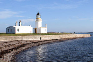
Chanonry Ness is a sharp point at the end of a sandy spit projecting southward into Moray Firth at the beginning of the approach to Inverness. Located 2.5 km southeast of Fortrose, accessible by car. ARLHS # SCO-045 (A 3440)
| home | Scotland lights | map this |
| prev | region page | next |
| UK/Scotland () / Scotland SC78 |