latitude 41° 16' 17.3" N
longitude 72° 20' 35.5" W
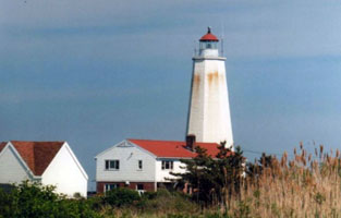
From Interstate 95, take exit 67 and proceed south on Elm Street to Main Street (Highway 154). Turn right onto Main and follow it for 2.5 miles to the Saybrook Point Inn and Marina. At that point, turn right on Bridge Street, crossing over South Cove, and then turn left onto Nibang Avenue. From Nibang, turn right onto Fenwick Avenue, left onto Agawam Avenue, and then left onto Neponset Avenue, where you will get a distant view ARLHS # USA-462 (J 0746)
| home | RICT lights | map this |
| prev | region page | next |
| ECU/RICT () / RICT CT7 |