latitude 44° 28' 2" N
longitude 68° 48' 42.1" W
August 19, 2017
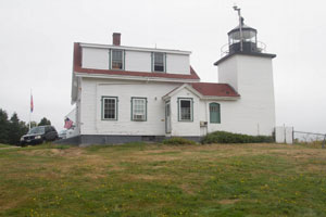
A state historic site located on the west side of the mouth of the Penobscot River in Cape Jellison near Searsport.
From Highway 1 near Stockton Springs, take Main Street into the town and then turn south on Cape Jellison Road. When the road splits after 0.8 miles, take the left fork and continue for 1.6 miles to the park entrance. The road just past the park entrance (Lighthouse Road) will take you directly to the lighthouse ARLHS # USA-296 (J 0086)
| home | Maine lights | map this |
| prev | region page | next |
| ECU/Maine () / Maine ME27 |