latitude 53° 17' 45.3" N
longitude 5° 3' 29.4" E
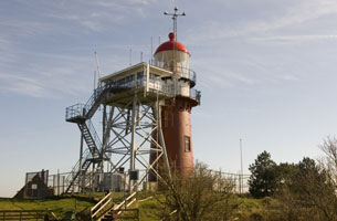
Located on the highest point of Vlieland, just west of the port town of Oost Vlieland. Vlieland is accessible by passenger ferry from Harlingen on the mainland; in the summer there is also ferry service from the northern end of Texel. ferry (B 0894)
| home | Netherlands lights | map this |
| prev | region page | next |
| CE/Netherlands () / Netherlands NL70 |